Chapter 15: Larger Serviced Villages
15.4 Larger Serviced Villages
As outlined in Chapter 2, Larger Serviced Rural Villages include:
- Palatine
- Ballinabrannagh
- Rathtoe
- Fennagh
- Myshall
- Clonegall
- Kildavin1
- Tinryland
These settlements are located throughout the County providing important local services with populations ranging generally over c.200 to 466. Population change between 2011-2016 varied greatly in this settlement category (see Table 15.4.1). Larger serviced villages contain schools, local employment and community facilities supporting the village and the wider rural area.
The Council will encourage and support the provision of local services, local employment opportunities, amenities and facilities within the development boundary of larger serviced villages subject to proper planning and environmental capacity considerations. Development in these villages shall be of an appropriate scale to support the local population and the immediate environs of the village.
|
Village |
Pop 2016 |
% Pop Change 2011-2016 |
Unit Allocation 2022-2028 |
|---|---|---|---|
|
Palatine |
398 |
13% |
25 |
|
Ballinabrannagh |
466 |
20% |
6 |
|
Rathoe |
304 |
0.3% |
18 |
|
Fennagh |
402 |
4.7% |
25 |
|
Myshall |
286 |
-5.3% |
23 |
|
Clonegal |
278 |
13.5% |
9 |
|
Kildavin |
184 |
-5.2% |
16 |
|
Tinryland |
378 |
-9.6% |
9 |
Table 15.4.1: Population Change 2011-2016 and Allocated Units 2022-2028
As outlined in Chapter 2, it is the policy of the Council to promote the serviced villages as an attractive housing option for rural areas of the County through the promotion of quality of life, placemaking and sufficient local service and infrastructure provision (Ref: CSP 10).
The larger serviced villages have been allocated an overall growth figure of 131 units (4%) over the period of the Plan 2022-2028. This will result in the larger serviced villages largely maintaining the % population allocation to this category of settlements as of 2016 Census. The level of growth allocated to Ballinabrannagh, Clonegall and Tinryland under the Core Strategy is impacted due to capacity constraints in wastewater infrastructure. These settlements have been allocated limited residential growth levels acknowledging the potential for individual private wastewater treatment units for one -off dwellings pending future upgrades of the public infrastructure. It is an objective of the Council to work and support Irish Water in progressing the “Small Towns and Villages Growth Programme” which is intended to provide growth capacity at wastewater treatment plants and water treatment plants in smaller settlements which would not otherwise be provided for in the current investment Plan (Ref: PW O2, Chapter 6). The upgrade of any treatment plant on foot of the foregoing scheme or such other scheme that may become available during the life of this plan, may facilitate additional levels of growth in those specified villages. Allocation of additional growth to those settlements following upgrades of the treatment plants must be informed by a monitoring programme on the implementation of the Core Strategy as provided in Chapter 2. Any significant reallocation of growth between the settlement tiers may require a variation of the County Development Plan.
Larger Serviced Village – Strategic Policies
It is the policy of the Council to:
| LSV. P1: | Facilitate development at a sustainable level, addressing vacancy, infill / brownfield development while supporting small scale residential schemes, local services, small scale employment and community facilities. The Council will support high quality designed development on sites within the village boundaries subject to proper planning considerations and the environmental carrying capacity of the area. |
| LSV. P2: | To support the development of a “New Homes in Small Towns and villages” initiative which would augment the delivery of actions by Local Authorities, Irish Water, communities and other stakeholders in the provision of services and serviced sites to create “build your own home” opportunities within the existing footprint of rural settlements to provide new homes to meet housing demand. |
Larger Serviced Villages - Objective
It is an objective of the Council to:
| LSV. O1: | Monitor and review Larger serviced villages in the County, across the lifetime of the Plan, in order to ensure compatibility with the Core Strategy and environmental protection objectives. |
15.4.1 Palatine Village
Overall Objective
To promote Palatine Village as a settlement with a strong village character to be protected and enhanced, while strengthening the existing and proposed services and supporting growth of the local community to sustainable levels in accordance with the provisions of the Core Strategy.
Palatine – Policies
It is the policy of the Council to:
Consolidate Village Form
| PL. P1: | Consolidate the village form and built fabric around existing nodes delineated by a designated village expansion area, that would maximise the existing services and historic investment in the village while creating a sustainable mixed-use village environment |
| PL. P2: | Seek the reuse where possible of brownfield lands, underutilised buildings / out buildings within the village boundary where same would make a positive contribution in maintaining the character of the settlement. |
Village Design
| PL. P3: | Seek to ensure that all development proposals have regard to the character, form and scale of the existing village and comprises of a high-quality design which will make a positive contribution to the character of the area. The proposed design shall be informed by the principles contained in Chapter 12 and shall emerge from careful analysis of the site location, surrounding context and the specific characteristics of the site itself. Specific features that contribute to the character of an area e.g. trees, hedgerows, stone walls, heritage features etc shall be carefully retained and integrated into the proposed design. |
Placemaking
| PL. P4: | Protect and enhance the unique village character of Palatine through strengthening the sense of place / public realm including the potential for improved linkages with Burton Hall demesne and architectural heritage in the village. |
Infill Development and Alternative to One-off Houses
| PL. P5: | Protect and enhance the unique village character of Palatine through strengthening the sense of place / public realm including the potential for improved linkages with Burton Hall demesne and architectural heritage in the village. |
Dual Village functions and services
| PL. P6: | Support the complementary functions of Palatine Village with Urglin / Rutland and Bennekerry/ Johnstown in order that important services and infrastructure are shared where practical and not unnecessarily duplicated e.g. churches, school, GAA club etc. |
Amenities
| PL. P7: | Protect and enhance the high-quality natural amenities present in and surrounding the village which form part of the village setting e.g. the long mile, trees, boundary hedgerows, fields etc. |
| PL. P8: | Promote the retention of hedgerows and trees as the traditional boundary form which is a characteristic of the village. These should be incorporated in future development proposals. |
| PL. P9: | Promote the development of social and recreational infrastructure with appropriately designated areas in the village e.g. village park, play areas, sports field, community facilities etc. |
| PL. P10: | Promote the upkeep and maintenance of the entrances to Palatine village and strengthen the sense of arrival through hard and soft landscaping etc. |
Screening and Woodland Character
| PL. P11: | Require that future village developments are appropriately screened from the surrounding countryside including the Long Mile through provision of adequate landscaping, hedgerows and maintaining the woodland character of the village. |
Built Heritage
| PL. P12: |
Support the retention of buildings with architectural merit, significant architectural features and historic/heritage structures that contribute to the village character and setting such as:
|
Roads and Footpaths
| PL. P13: | Assess the need for improved roads, footpaths and improved permeability in relation to existing and future projected traffic generation in the village and give due consideration to the need to establish a safe and quality village environment and village character. |
| PL. P14: | Seek to ensure that strong linkages to the village core are provided and that new development addresses connectivity to the core of the settlement, community / service facilities with the provision of footpaths/ cycleways, where deemed appropriate. |
Flood Risk Management
| PL. P15: |
Manage flood risk in Palatine in accordance with the following provisions: 1. Development on part of the Village Core residential lands to the east of the L4015 and within Flood Zone A and Flood Zone B shall be:
Any future development should be subject to an FRA which should follow the general guidance provided in Section 6 of the SFRA and must specifically address the following:
2. Development within areas of the existing residential zoning within the Meadowbank Estate within Flood Zone A and Flood Zone B shall be:
Any future development should be subject to an FRA which should follow the general guidance provided in Section 6 of the SFRA and must specifically address the following:
3. Any future expansion of the WWTP should be subject to an FRA which should follow the general guidance provided in Section 6 of the SFRA and must specifically address the following
|
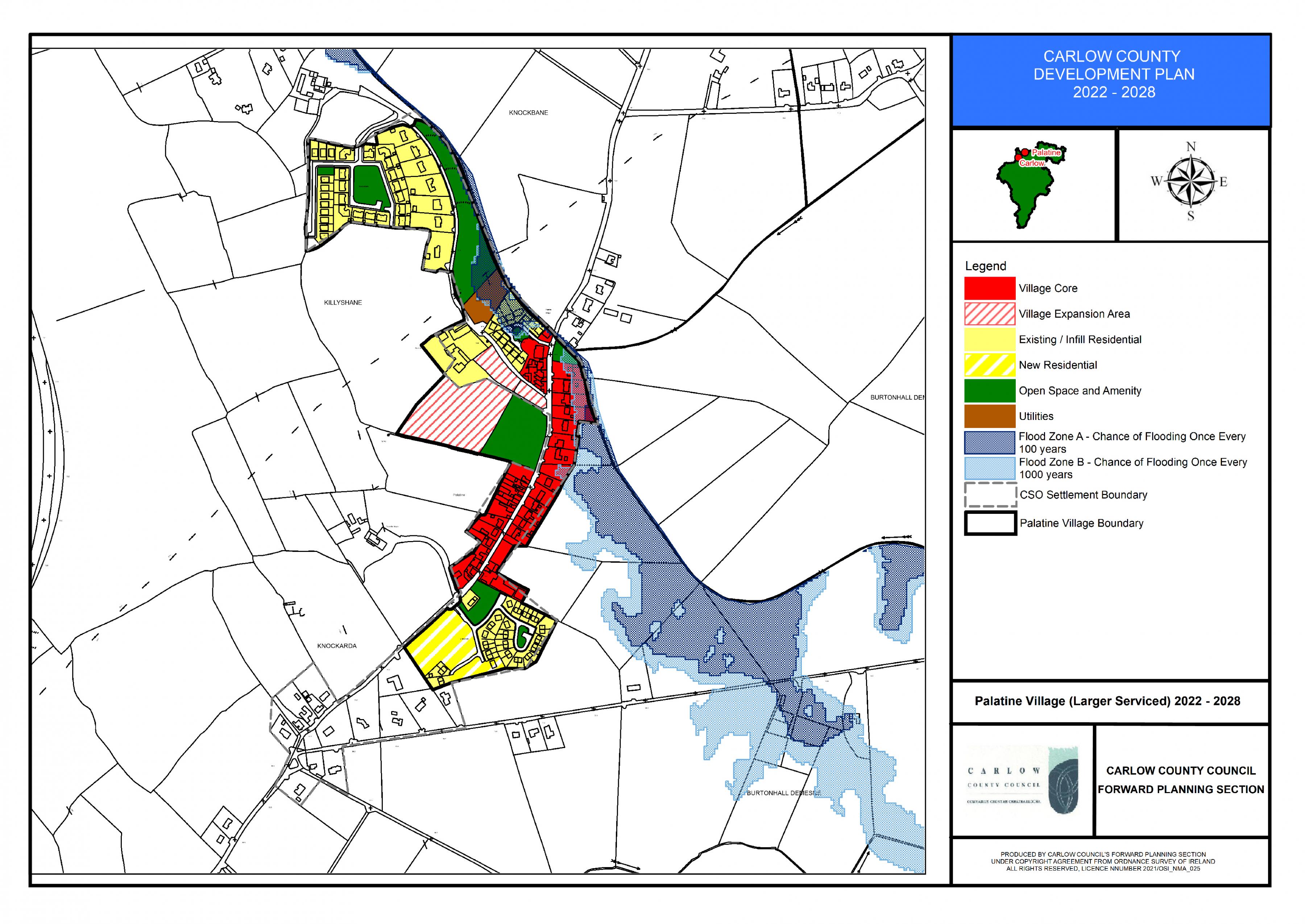
Palatine Land Use Zoning Map
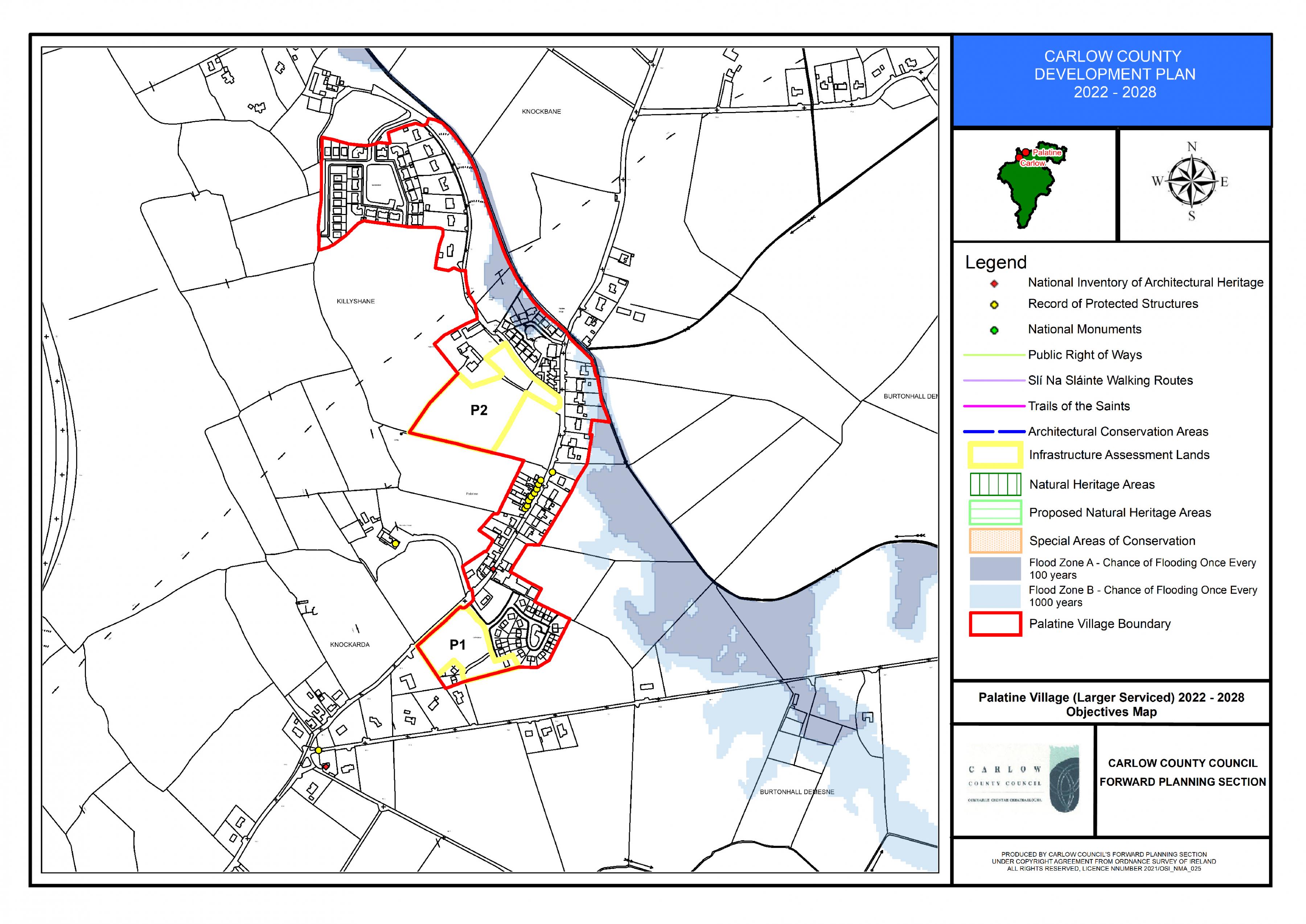
Palatine Objectives Maps
15.4.2 Ballinabrannagh / Raheendoran Village
Overall Objective
To promote Ballinabrannagh / Raheendoran village area as a settlement with a strong village character to be protected and enhanced, while strengthening the existing and proposed services and supporting growth of the local community to sustainable levels subject to environmental capacity constraints.
Ballinabrannagh / Raheendoran– Policies
It is the policy of the Council to:
Physical Infrastructure
| BB. P1: | Ensure that future development will be subject to the availability and adequate provision of the necessary physical infrastructure and specifically be subject to the upgrading of the existing sewage plant to a level that can accommodate future development and population increases. |
Dual village Functions and Services
| BB. P2: | Support the complementary functions of Ballinabrannagh and Raheendoran to share their social and recreational, physical and heritage services and recognise their interdependence and shared responsibility to protect and facilitate sustainable development. |
Consolidate Village Form
| BB. P3: | Consolidate the settlement form, built fabric and overall village area in Ballinabrannagh by the provision of a mixed-use designated village expansion area subject to availability of wastewater infrastructural upgrades that would maximise the existing services and historic investment in the village while creating a sustainable environment. |
| BB P4: | Seek to ensure that all development proposals have regard to the character, form and scale of the existing village and comprises of a high-quality design which will make a positive contribution to the character of the area. The proposed design shall be informed by the principles contained in Chapter 12 and shall emerge from careful analysis of the site location, surrounding context and the specific characteristics of the site itself. Specific features that contribute to the character of the area e.g. trees, hedgerows, stone walls, natural and built heritage etc shall be carefully retained and integrated / referenced as appropriate in the proposed design. |
Placemaking
| BB. P5: | Protect and enhance the village character of Ballinabrannagh /Raheendoran village area through strengthening the sense of place, natural amenity heritage, historic heritage and architectural heritage in the area. |
Entrances and Gateways to Village
| BB. P6: |
Promote the development of defined entrances to Ballinabrannagh and Raheendoran settlements and strengthen the sense of arrival when entering the village i.e. i) The establishment of landscaped pocket parks/amenities. ii) The improvement of the southern, eastern and northern approach roads to provide a sense of arrival in the village e.g. streetscape, landscaped amenity, feature etc. |
Infill Development and Alternative to One-off Houses
| BB. P7: | Encourage infill development within the village area development boundaries, located in proximity to services thus creating sustainable developments and also to provide for developments at low densities as an alternative to one-off houses in the countryside. |
| BB. P8: |
To seek the satisfactory overall completion of Gort na Greine Housing Development and to consider the provision of a maximum of 22 no. residential units on new residential zoned lands, subject to the appropriate phasing of the scheme and high-quality design and siting considerations, which will provide for an integrated development including pedestrian permeability through the site to the existing adjoining development. The scheme shall also provide high-quality landscaping and public open space provision and shall comply all other proper planning and sustainable development considerations as appropriate. |
Social and Community Infrastructure
| BB. P9: | Promote the improvement of existing social and recreational infrastructure within appropriately designated areas in the village. |
Educational Facilities
| BB. P10: | Support the expansion of existing educational facilities within Ballinabrannagh and to promote the provision of adequate childcare facilities to meet local demand. |
Natural Amenities
| BB. P11: | Protect and enhance the high-quality natural amenities present in and surrounding the village which form part of the village setting e.g. forests, trees, open agricultural lands, Barrow River, Killeshin Hills, Milford, Barrow Track etc. The Council will support improved accessibility to amenity uses in the wider rural environment including the River Barrow subject to Habitat Assessment considerations. |
| BB. P12: | Promote the retention of trees and hedgerows as the traditional boundary form and to encourage the preservation of significant trees and groupings of trees within the village in order to retain and encourage the woodland nature and natural screening of the village setting. |
| BB. P13: | Require future village developments to be adequately screened from the surrounding countryside through the provision of adequate landscaping, hedgerows and maintaining the woodland character of the village areas. |
Built Heritage
| BB. P14: | Support the retention of buildings with architectural merit, significant architectural features, historic /heritage structures and archaeological sites that contribute to the village character and setting. |
Roads and Footpaths
| BB. P15: | Minimise the traffic impact from industrial activities in the area through the application of DMURS within the settlement and to assess the need for improved roads, footpaths and improved permeability in relation to existing and future projected traffic generation in the village and give due consideration to the need to establish a safe and quality village environment and village character. |
| BB. P16: | Seek to ensure that strong linkages to the village core are provided and that new development addresses connectivity to the core of the settlement, community / service facilities with the provision of footpaths/ cycleways, where deemed appropriate. |
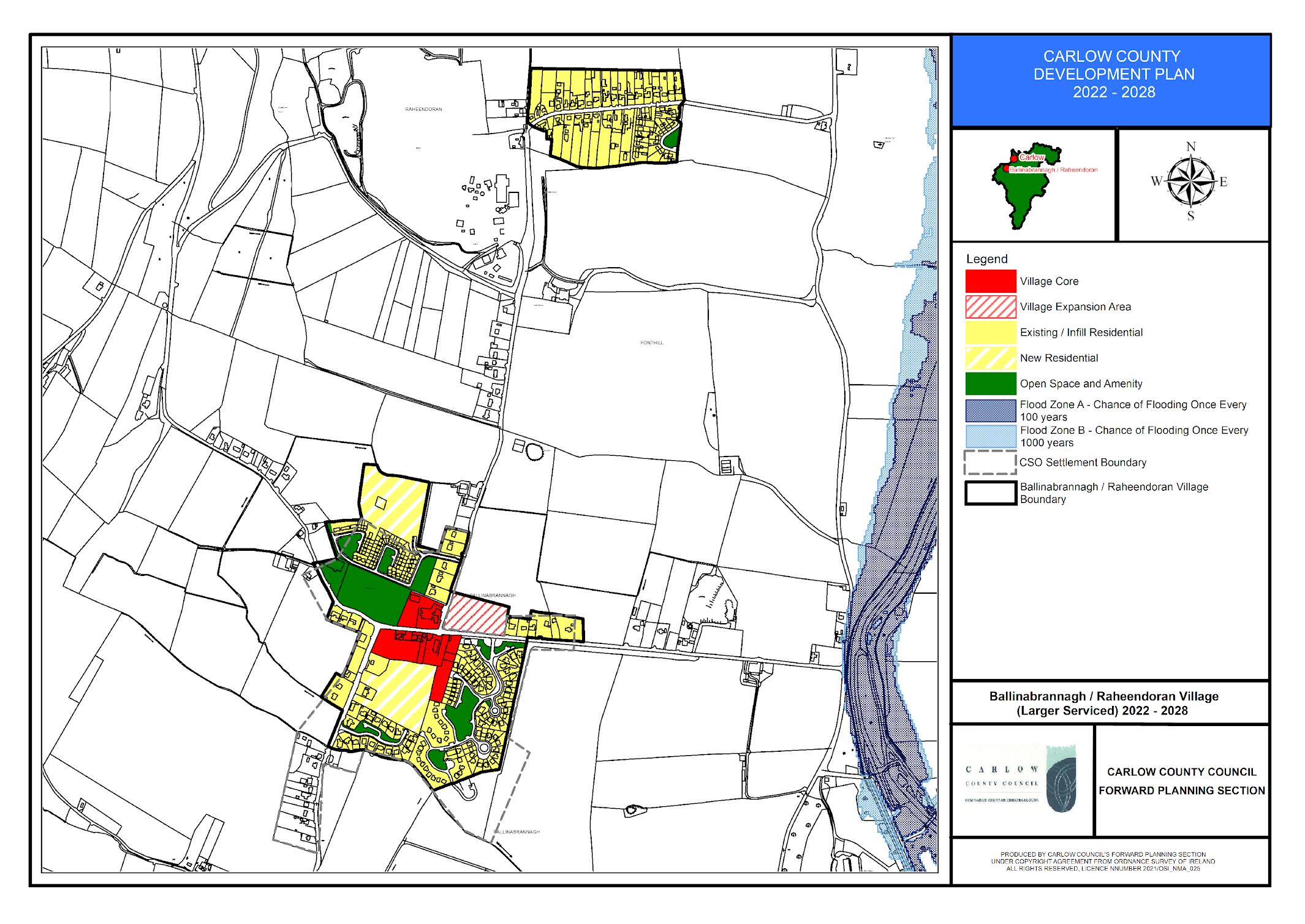
Ballinabrannagh/Raheendoran Land Use Zoning Map
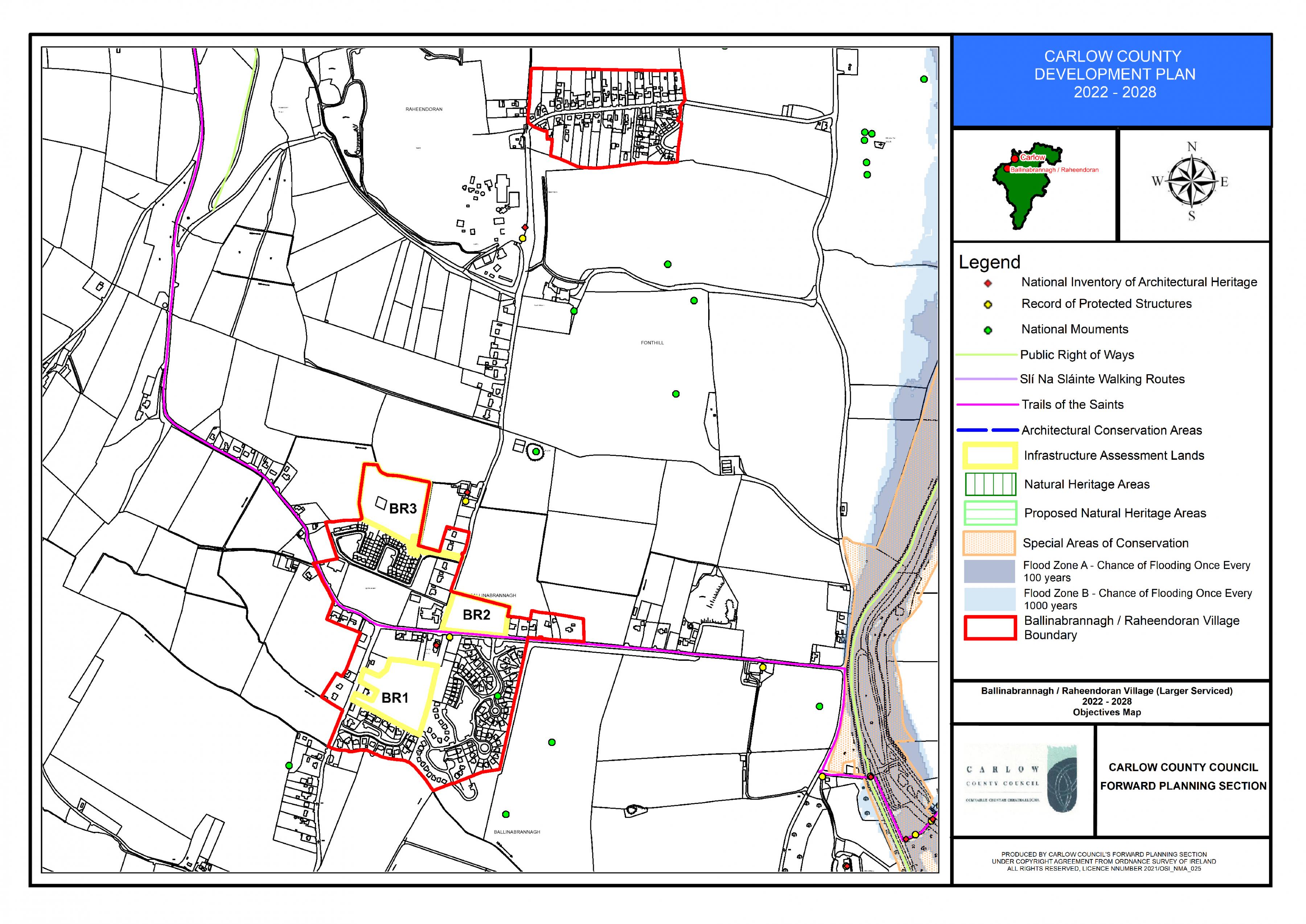
Ballinabrannagh/Raheendoran Objectives Map
15.4.3 Rathtoe Village
Overall Objective
To promote Rathtoe village area as a settlement with a strong village character set within a traditional agricultural countryside. This character should be protected and enhanced, while strengthening the existing and proposed services and supporting growth of the local community to sustainable levels in accordance with the provisions of the Core Strategy.
Rathtoe– Policies
It is the policy of the Council to:
Consolidate Village Form
| RT. P1: | Consolidate and balance the village form, built fabric and development around the village centre that would maximise the existing service and historic investment in the village while creating a sustainable village environment. |
| RT. P2: | Facilitate future village expansion to the west of the existing established village centre, to optimise the potential for mixed use including social and recreational infrastructure in accordance with potential need. The village expansion area shall be subject to a detailed site brief which will address mix of uses, connectivity and integration with the existing adjoining uses. |
| RT. P3: | Encourage and protect the rural country amenity character of the village through linear but converging greenbelts that aspire to strengthen the rural character, enhance the sense of place and provide views toward focus points, buildings of significant architectural merit e.g. church and old school and uninterrupted open views to the surrounding countryside. |
Village Main Entrances
| RT. P4: | Promote the development of a well-defined entrance to Rathtoe Village and strengthen the sense of arrival and the image of the village, through the provision of high quality landscaped entrance and built edge to the village core. |
| RT. P5: | Maintain and enhance the rural amenity character through the continued use of linear open spaces focused on the village centre and providing for interdependent linkage and a linked network of pedestrian pathways/cycle lanes, while maintaining open unobstructed views toward the countryside and visual reference to the church building focal point. |
| RT. P6: | Seek to ensure that all development proposals have regard to the character, form and scale of the existing village and comprises of a high-quality design which will make a positive contribution to the character of the area. The proposed design shall be informed by the principles contained in Chapter 12 and shall emerge from careful analysis of the site location, surrounding context and the specific characteristics of the site itself. Specific features that contribute to the character of an area e.g. trees , hedgerows, stone walls, natural and built heritage etc shall be carefully retained and integrated / referenced as appropriate in the proposed design. |
Placemaking
| RT. P7: | Protect and enhance the village character of Rathtoe through strengthening the sense of place, natural amenity heritage, historic heritage and architectural heritage in the area. |
Infill Development and Alternative to One-off Houses
| RT. P8: | Encourage infill development within the village area development boundaries, located in proximity to services thus creating sustainable developments and also to provide for developments at low densities as an alternative to one-off houses in the countryside. |
Educational Facilities
| RT. P9: | Support the expansion of existing educational facilities within Rathtoe to support the provision of any additional childcare facilities required to meet local demand. |
Built and Natural Heritage
| RT. P10: | Recognise the significant archaeological heritage in the area which dates from prehistoric time and to seek to protect same for future generations. |
| RT. P11: | Promote the retention of hedgerows as the traditional boundary form which is a characteristic of the village. These should be incorporated in future development proposals. |
| RT. P12: | Encourage the preservation of significant trees and groupings of trees within the village in order to retain and encourage the woodland nature and natural screening of the village setting. |
| RT. P13: | Support the retention of buildings with architectural merit, significant architectural features, historic/heritage structures and archaeological sites that contribute to the village character and setting. |
Roads and Footpaths
| RT. P14: | Assess the need for improved roads, footpaths and improved permeability in relation to existing and future projected traffic generation in the village and give due consideration to the need to establish a safe and quality village environment and village character. |
| RT. P15: | Seek to ensure that strong linkages to the village core are provided and that new development addresses connectivity to the core of the settlement, community / service facilities with the provision of footpaths/ cycleways, where deemed appropriate. |
Flood Risk Management
| RT. P16: |
Manage flood risk in Rathtoe in accordance with the following provisions: New highly vulnerable development is only appropriate within Flood Zone C. New less vulnerable development is only appropriate within Flood Zone B/C. Any future development adjacent to the Flood Zones should be subject to an FRA which must follow the general guidance provided in Section 6 of the SFRA and specifically address the following:
Any development shall also be required to be built in accordance with Carlow County Council SuDS Policy.
|
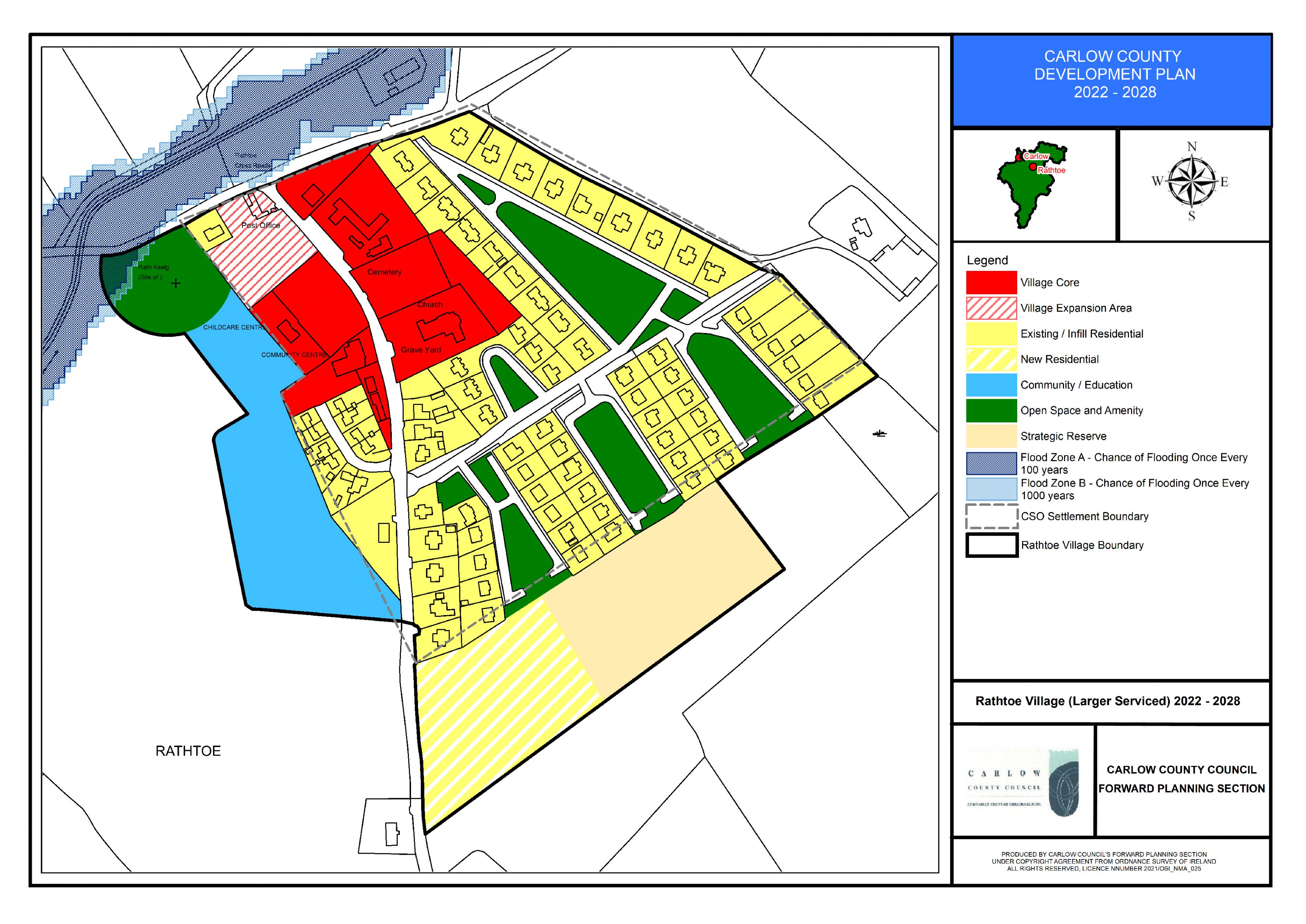
Rathtoe Land Use Zoning Map
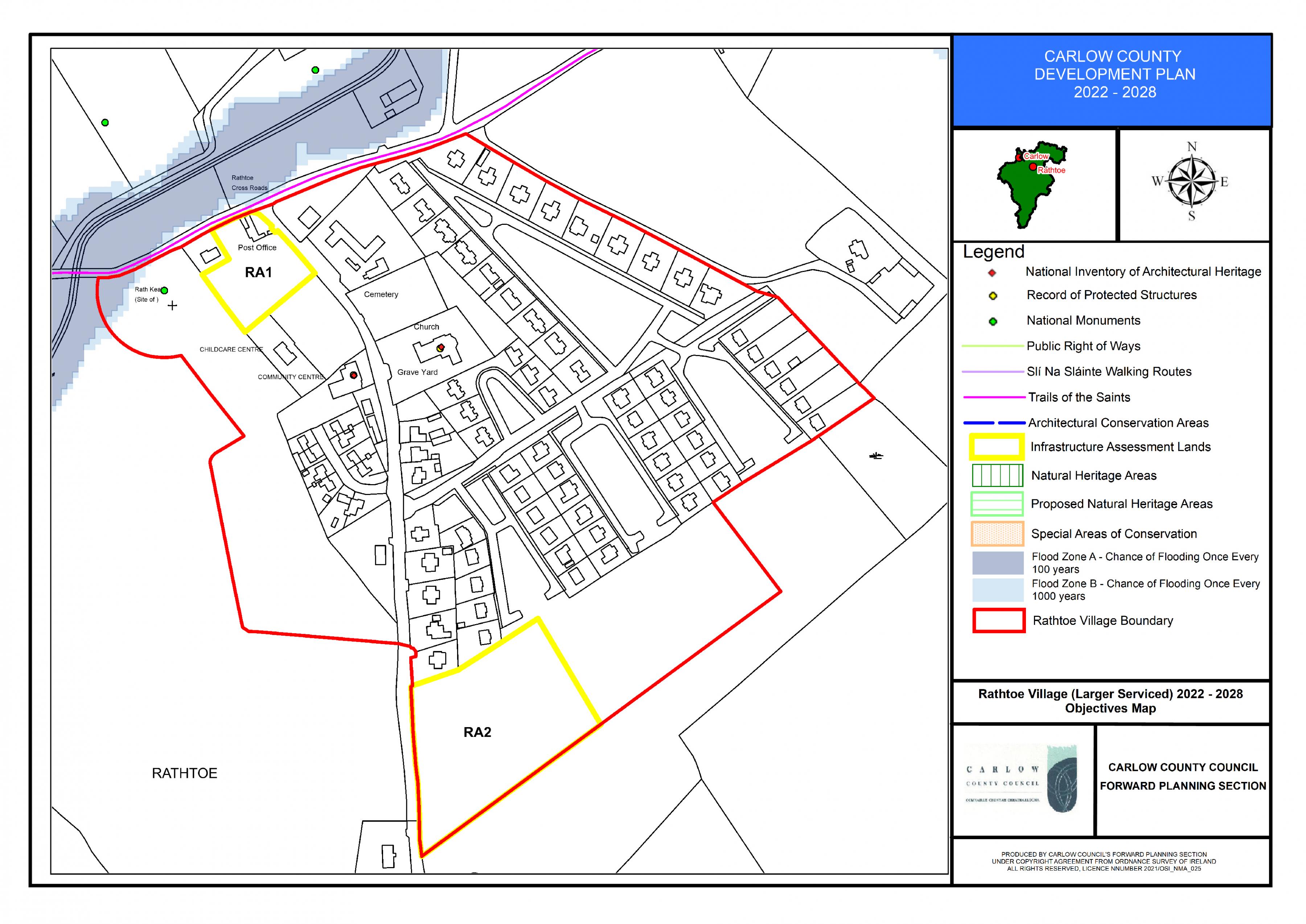
Rathtoe Objectives Map
15.4.4 Fennagh Village
Overall Objective
To promote Fennagh village as a settlement with a strong village character to be protected and enhanced, while strengthening the existing and proposed services and supporting growth of the local community to sustainable levels.
Fennagh – Policies
It is the policy of the Council to:
Consolidate Village Form
| FN. P1: | Consolidate the village form and built fabric within the existing village core and expansion area to include a village green located along the banks of the river, that would maximise the existing services and historic investment in the village while creating a sustainable mixed-use village environment. The village expansion area shall be subject to a detailed site brief which will address mix of uses overlooking a village green associated with the River and integration with adjoining uses. |
| FN. P2: | Seek the reuse where possible of brownfield lands, underutilised buildings / out buildings within the village boundary where same would make a positive contribution in maintaining the character of the settlement. |
| FN. P3: | To support the development of backland areas in the centre of the villages of an appropriate type, scale and character that will contribute to a more compact settlement core and which provide good linkages and connectivity to the village centre / local facilities. |
Village Design
| FN. P4: | Seek to ensure that all development proposals have regard to the character, form and scale of the existing village and comprises of a high-quality design which will make a positive contribution to the character of the area. The proposed design shall be informed by the principles contained in Chapter 12 and shall emerge from careful analysis of the site location, surrounding context and the specific characteristics of the site itself. Specific features that contribute to the character of an area e.g. trees , hedgerows, stone walls, heritage features etc shall be carefully retained and integrated into the proposed design. |
Placemaking
| FN. P5: | Protect and enhance the village character of Fennagh through strengthening the sense of place / public realm improvements, additional landscaping and planting and through the protection of the architectural heritage of granite buildings in the village. |
Entrances and Gateways to Village
| FN. P6: | Promote the upkeep and maintenance of entrances to Fennagh village and strengthen the sense of arrival when entering the village e.g. soft landscaping etc. |
Infill Development and Alternative to One-off Houses
| FN. P7: | Encourage infill development within the village development boundaries, located in proximity to services thus creating sustainable developments. |
| FN. P8: | Seek the completion of the River Court (10 no. units) and Granite Court (8 no. units) unfinished housing estates with an enhanced access and environment for existing residents (road, footpath maintenance, lighting etc.) |
Social and Community Infrastructure
| FN. P9: | Promote the development of social and recreational infrastructure within the village to accommodate future need. |
Built Heritage
| FN. P10: | Support the retention of buildings with architectural merit, archaeological heritage, significant architectural features and historic/heritage structures that contribute to the village character and setting including Fennagh Estate Cottages, Fennagh Milestone and All Saints Chapel. |
Amenities
| FN. P11: | Protect and enhance natural amenities present in and surrounding the village which form part of the village setting e.g. tributary of the River Burren which flows through the village, boundary trees, hedgerows, fields etc. |
| FN. P12: | Promote the retention of hedgerows as the traditional boundary form which is a characteristic of the village. These should be incorporated in future development proposals. |
Screening and Woodland Character
| FN. P13: | Require that future village development is appropriately screened from the surrounding countryside through provision of adequate landscaping, hedgerows and maintaining the woodland character of the village. |
Roads and Footpaths
| FN. P14: | Assess the need for improved roads, footpaths and improved permeability in relation to existing and future projected traffic generation in the village and give due consideration to the need to establish a safe and quality village environment and village character. |
| FN. P15: | Encourage the provision of strong linkages to the village core from established community uses including the Centre of Excellence located outside the village and that new development addresses connectivity to the core of the settlement, community / service facilities with the provision of footpaths/ cycleways, where deemed appropriate. |
Flood Risk Management
| FN. P16: |
Manage flood risk in Fennagh in accordance with the following provisions: 1. For areas zoned existing residential within the Woodglade Estate within Flood Zone A and B, development shall be:
Any future development should be subject to an FRA which should follow the general guidance provided in Section 6 of the SFRA and must specifically address the following:
2. For part of the Village Core lands to the east of the R724 located within Flood Zone A and Flood Zone B. Any future expansion of the WWTP should be subject to an FRA, it would not be appropriate to place residential or other highly vulnerable use in the Village Core lands. Any future FRA should follow the general guidance provided in Section 6 of the SFRA and must specifically address the following:
3. Parts of the Creche and Church site are located within Flood Zone A/B. Any future expansion of the creche should be subject to an FRA which should follow the general guidance provided in Section 6 of the SFRA and must specifically address the following:
|
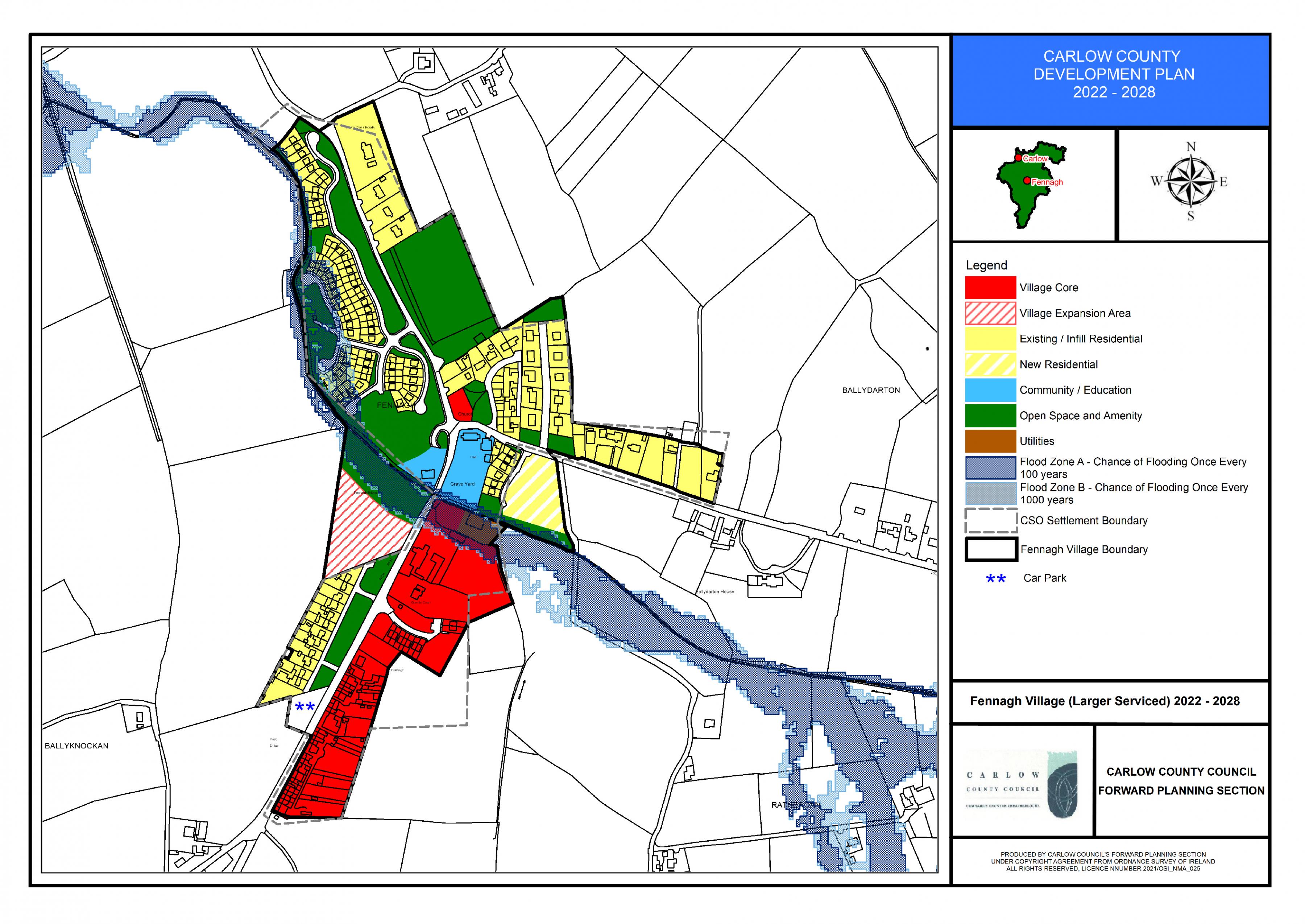
Fennagh Land Use Zoning Map

Fennagh Objectives Map
15.4.5 Myshall Village
Overall Objective
To promote Myshall as a settlement with a strong village character which is rich in natural environmental assets and historical heritage, as a village to be protected and enhanced, while strengthening the existing and proposed services and supporting growth of the local community to sustainable levels.
Myshall – Policies
It is the policy of the Council to:
Consolidate Village Form
| MY. P1: | Consolidate the village form and built fabric within the existing village core area that would maximise the existing services and historic investment in the village while creating a sustainable mixed-use village environment. |
| MY. P2: | Seek the reuse where possible of brownfield lands, vacant/ underutilised buildings / out buildings within the village boundary where same would make a positive contribution in maintaining the character of the settlement. |
| MY. P3: | To support the development of backland areas in the centre of the village of an appropriate type, scale and character that will contribute to a more compact settlement core and which provides good linkages and connectivity to the village centre / local facilities. |
Village Design
| MY. P4: | Seek to ensure that all development proposals have regard to the character, form and scale of the existing village and comprises of a high-quality design which will make a positive contribution to the character of the area. The proposed design shall be informed by the principles contained in Chapter 12 and shall emerge from careful analysis of the site location, surrounding context and the specific characteristics of the site itself. Specific features that contribute to the character of an area e.g. trees , hedgerows, stone walls, heritage features etc shall be carefully retained and integrated into the proposed design. |
Placemaking
| MY. P5: |
Protect and enhance the unique village character of Myshall by strengthening the public realm through the:
|
Tourism Opportunities
| MY. P6: | Advance Myshall as a hub for tourism at an appropriate scale, and to support sustainable growth of tourism related uses by harnessing the built and natural heritage characteristics of the village and the surrounding rural area including, the unique attributes of Mount Leinster. |
Entrances and Gateways to Village
| MY. P7: | Promote the continued enhancement of defined entrances to Myshall village and strengthen the sense of arrival through additional landscaping, planting etc. |
Infill Development and Alternative to One-off Houses
| MY. P8: | Encourage infill development within the village development boundaries, located in proximity to services thus creating sustainable developments. |
| MY. P9: | Seek the upgrade of the Sliabh Ban housing estate with an enhanced access and environment for existing residents (road, footpath maintenance, lighting etc.) |
| MY. P10: | Promote the provision of low density / serviced sites (12 no. sites) on the existing permitted new residentially zoned site as an alternative to one off housing in the rural countryside and to support the sustainable development of the village. |
Social and Community Infrastructure
| MY. P11: | Promote the development of social and recreational infrastructure within the village to accommodate future need. |
Educational Facilities
| MY. P12: | Support the expansion of existing educational facilities within Myshall and to promote the provision of adequate childcare facilities to meet local demand. |
Built Heritage
| MY. P13: | Support the retention of buildings with architectural merit, archaeological heritage, significant architectural features and historic/heritage structures that contribute to the village character and setting including Myshall Catholic Church and the Adelaide Memorial Church a building of National significance which serves as a key visitor attraction for the village. |
Amenities
| MY. P14: | Protect and enhance the high-quality natural amenities present in and surrounding the village which form part of the village setting e.g. Tobar Bhride, Holy Well, the pump, trees, boundary hedgerows, fields etc. |
| MY. P15: | Promote the retention of trees and hedgerows as the traditional boundary form which is a characteristic of the village. These should be incorporated in future development proposals. |
Screening and Woodland Character
| MY. P16: | Require that future village development is appropriately screened from the surrounding countryside through provision of adequate landscaping, hedgerows and maintaining the woodland character of the village. |
Roads and Footpaths
| MY. P17: | Assess the need for improved roads, footpaths and improved permeability in relation to existing and future projected traffic generation in the village and give due consideration to the need to establish a safe and quality village environment and village character. |
| MY. P18: | Seek to ensure that strong linkages to the village core are provided and that new development addresses connectivity to the core of the settlement, community / service facilities with the provision of footpaths/ cycleways, where deemed appropriate. |
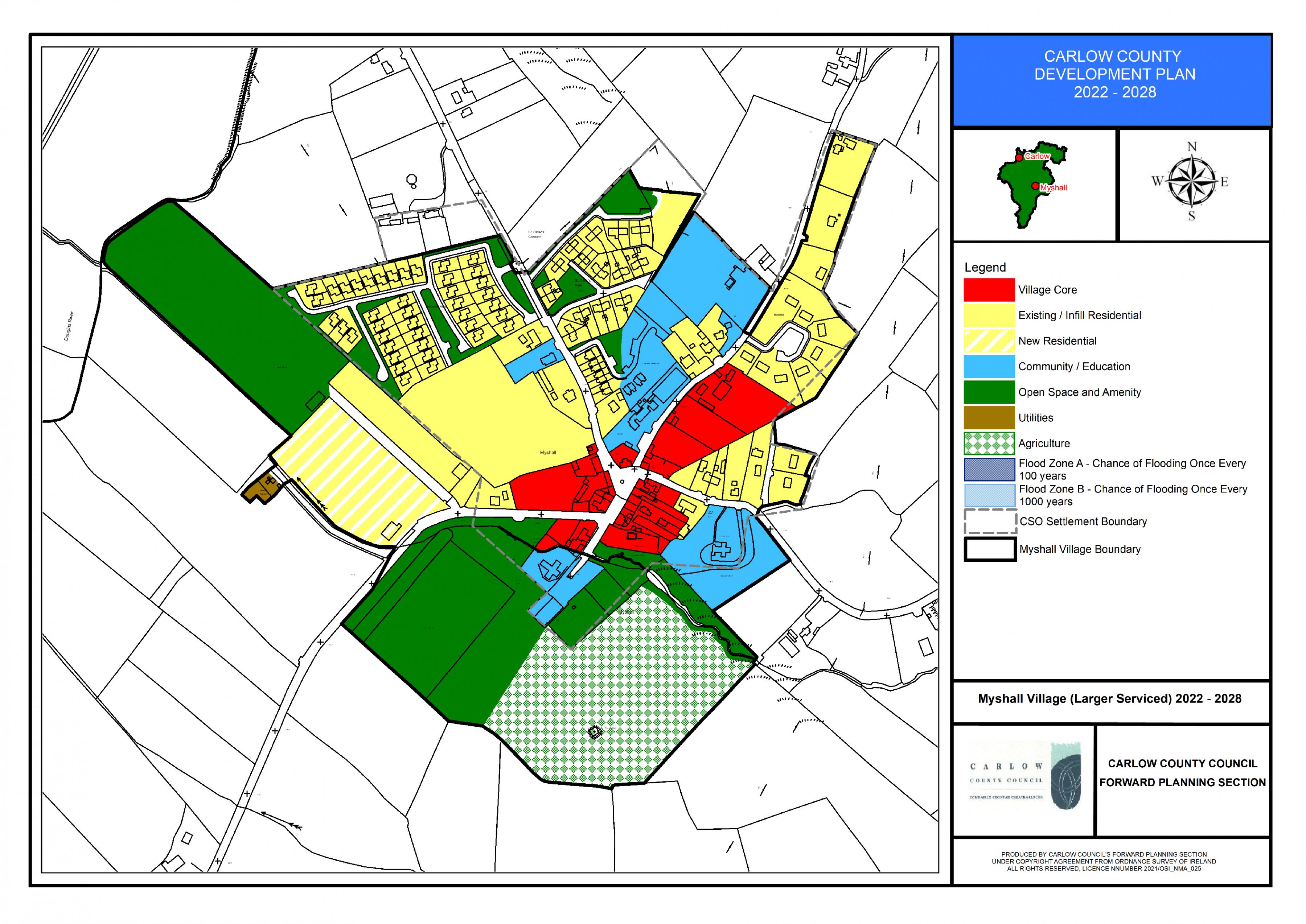 Myshall Land Use Zoning Map
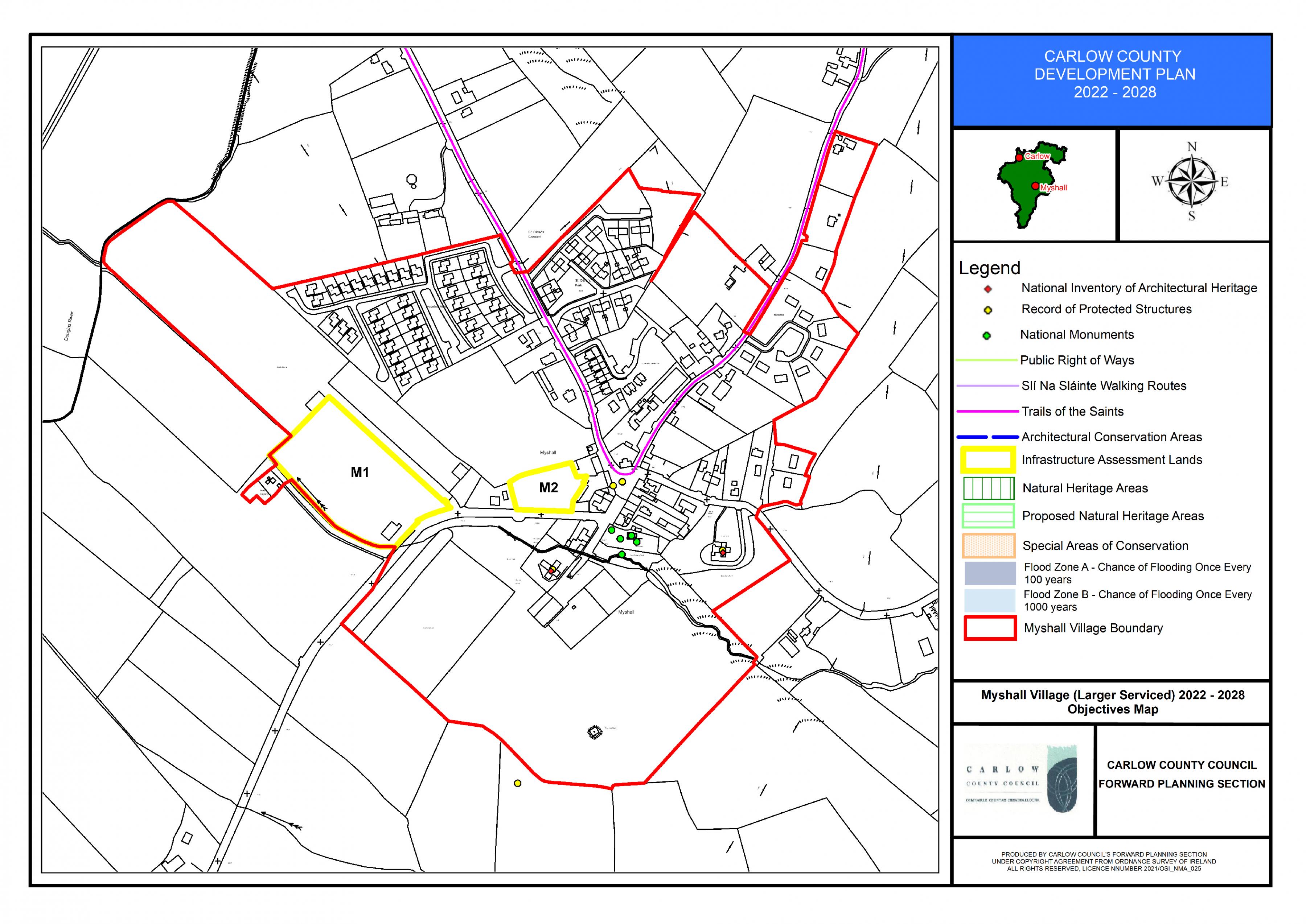
Myshall Objectives Map
15.4.6 Clonegall Village
Overall Objective
To retain, protect and enhance the unique natural and built heritage characteristics of Clonegall which is located in a high-quality attractive rural landscape, while seeking to strengthen the level of services and community facilities to cater for local demand while accommodating growth at a sustainable level.
Clonegall – Policies
It is the policy of the Council to:
Consolidate Village Form
| CG. P1: | Consolidate the village form and built fabric within the existing village core area that would maximise the existing services and historic investment in the village while creating a sustainable mixed-use village environment. |
| CG. P2: | Seek the reuse where possible of brownfield lands, underutilised buildings / out buildings within the village boundary where same would make a positive contribution in maintaining the character of the settlement. |
| CG. P3: | To support the development of backland areas in the centre of the village of an appropriate type, scale and character that will contribute to a more compact settlement core and which provide good linkages and connectivity to the village centre / local facilities. |
Village Design
| CG. P4: | Seek to ensure that all development proposals have regard to the unique architectural character, form and scale of the existing village and comprises of a high-quality design which will make a positive contribution to the character of the area. The proposed design shall be informed by the principles contained in Chapter 12 and shall emerge from careful analysis of the site location, surrounding context and the specific characteristics of the site itself. Specific features that contribute to the character of an area e.g. trees , hedgerows, stone walls, heritage features etc shall be carefully retained and integrated into the proposed design. |
Placemaking
| CG. P5: | Protect and enhance the village character of Clonegall through strengthening the sense of place / public realm improvements, additional landscaping and planting and through the protection of the natural and built heritage of the village. |
Dual Village Functions and Services
| CG. P6: | Support the complementary functions of Clonegall with Watch House Village in Co. Wexford in order that important services and infrastructure are shared where practical. |
Tourism Opportunities
| CG. P7: | Advance Clonegall as a hub for tourism at an appropriate scale, and to support sustainable growth of tourism related uses by harnessing the built and natural heritage characteristics of the village including, the high-quality built environment and natural environment including the nationally significant Huntington Castle and Demesne. |
Infill Development and Alternative to One-off Houses
| CG. P8: | Encourage infill development within the village area development boundaries, located in proximity to services thus creating sustainable developments and also to provide for developments at low densities as an alternative to one-off houses in the countryside. In the absence of available infrastructural capacity in Clonegall limited residential development on individual treatment plants where environmentally acceptable and where the proposed development would complement the character of the village maybe considered on undeveloped lands within the designated development boundary subject to compliance with the core strategy. |
Social and Community Infrastructure
| CG. P9: | Promote the development of social and recreational infrastructure within the village to accommodate future need. |
Educational Facilities
| CG. P10: | Support the expansion of existing educational facilities within Clonegall and to promote the provision of adequate childcare facilities to meet local demand. |
Natural Amenities
| CG. P11: | Protect and enhance the high-quality natural amenities present in and surrounding the village which contribute to the amenity of the village e.g. the River Derry, the Wicklow Way, trees, boundary hedgerows, fields etc. |
| CG. P12: | Maximise recreational opportunities for the village through the proposed connection/link between the Wicklow Way and the South Leinster Way which traverses through Clonegall and seek to ensure that any infrastructure within the village associated with same is of a high quality appropriate to the character of the village. |
| CG. P13: | Promote the retention of trees and hedgerows as the traditional boundary form which is a characteristic of the village. These should be incorporated in future development proposals. |
Screening and Woodland Character
| CG. P14: | Require that future village development is appropriately screened from the surrounding countryside through provision of adequate landscaping, hedgerows and maintaining the woodland character of the village. |
Built Heritage
| CG. P15: | Support the retention of buildings with architectural merit, archaeological heritage, significant architectural features and historic/heritage structures that contribute to the village character and setting including Huntington Castle, St. Brigids Church, St Fiacce’s Church, the Old Rectory , the Watch House Cross, the Stone from O’Connors Forge, The Weavers Cottages and St. Brigid’s Community Hall. |
| CG. P16: | Investigate the designation of an Architectural Conservation Area(s) within Clonegall village in order to protect and enhance the historic character and heritage value of the village. |
Roads and Footpaths
| CG. P17: | Assess the need for improved roads, footpaths and improved permeability in relation to existing and future projected traffic generation in the village and give due consideration to the need to establish a safe and quality village environment and village character. |
| CG. P18: | Seek to ensure that strong linkages to the village core are provided and that new development addresses connectivity to the core of the settlement, community / service facilities with the provision of footpaths/ cycleways, where deemed appropriate. |
Flood Risk Management
| CG. P19: |
Manage flood risk on part of the village core lands to the east of the L2021 within Flood Zone A and B in Clonegal in accordance with the following provisions: Development shall be:
Any future development should be subject to an FRA which should follow the general guidance provided in Section 6 of the SFRA and must specifically address the following:
|
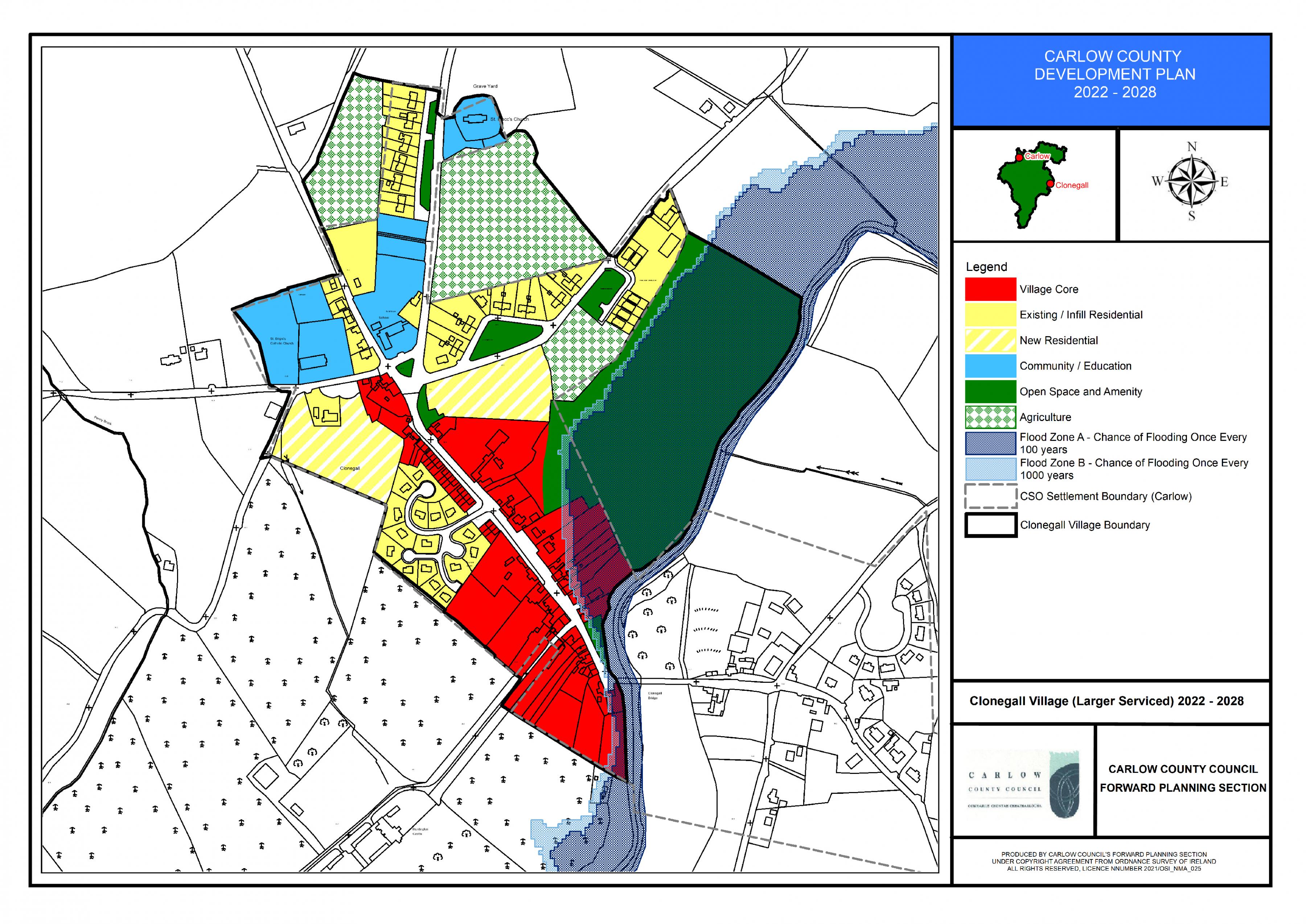
Clonegall Land Use Zoning Map
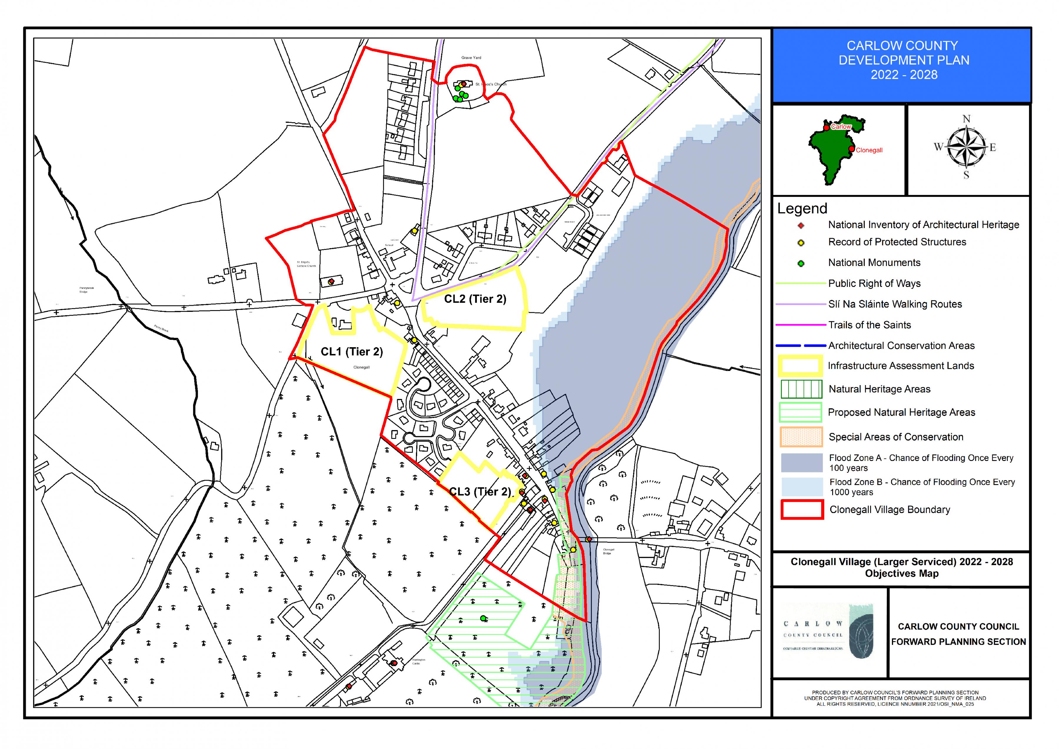
Clonegall Objectives Map
15.4.7 Kildavin Village
Overall Objective
To promote Kildavin village as a settlement with a strong village character, located in an attractive rural environment to be protected and enhanced, while strengthening the existing and proposed services and supporting growth of the local community addressing recent population decline to sustainable growth levels.
Kildavin – Policies
It is the policy of the Council to:
Consolidate Village Form
| KD. P1: | Consolidate the village form and built fabric within the existing village core and expansion area , that would maximise the existing services and historic investment in the village while creating a sustainable mixed-use village environment. The village expansion area shall be subject to a detailed site brief integrating with the existing adjoining uses. |
| KD. P2: | Seek the reinstatement of the built fabric and village frontage along the junction of main street and the R274 which is necessary to maintain the character of the settlement. |
| KD. P3: | Seek the reuse where possible of brownfield lands, underutilised buildings / out buildings within the village boundary where same would make a positive contribution in maintaining the character of the settlement. |
Village Design
| KD. P4: | Seek to ensure that all development proposals have regard to the character, form and scale of the existing village and comprises of a high-quality design which will make a positive contribution to the character of the area. The proposed design shall be informed by the principles contained in Chapter 12 and shall emerge from careful analysis of the site location, surrounding context and the specific characteristics of the site itself. Specific features that contribute to the character of an area e.g. trees , hedgerows, stone walls, heritage features etc shall be carefully retained and integrated into the proposed design. |
Placemaking
| KD. P5: | Protect and enhance the village character of Kildavin through strengthening the sense of place / public realm improvements, additional landscaping and planting and through the protection of the natural and built of the village. |
Entrances and Gateways to Village
| KD. P6: | Promote the enhancement of defined entrances to Kildavin village and strengthen the sense of arrival when entering the village e.g. soft landscaping / planting etc. |
Infill Development and Alternative to One-off Houses
| KD. P7: | Facilitate the provision of additional housing on lands zoned new residential and to encourage infill development on appropriately zoned land within the village development boundaries, located in proximity to services thus creating sustainable developments. |
| KD. P8: |
To facilitate low density residential development (max. no. 15 no. units) on lands located west of the village, south of the R724, subject to high-quality design and siting considerations, which will provide for an integrated development, and which shall also provide high-quality landscaping and public open space provision and shall comply all other proper planning and sustainable development considerations as appropriate. Design and layout considerations shall take account of The Spatial Planning and National Roads Guidelines, including appropriate set back from the N80 slip road, to ensure the strategic function and safety of the national road is safeguarded. |
Social and Community Infrastructure
| KD. P9: | Promote the development of social and recreational infrastructure within the village to accommodate future need. |
Educational Facilities
| KD. P10: | Support the expansion of existing educational facilities within Kildavin and to promote the provision of adequate childcare facilities to meet local demand. |
Built Heritage
| KD. P11: | Support the retention of buildings with architectural merit, archaeological heritage, significant architectural features and historic/heritage structures that contribute to the village character and setting including Saint Lazarians Church and Saint Pauls Church. |
| KD. P12: | Support and encourage the reuse of Kildavin House currently in a state of dereliction which is a protected structure for residential or such other higher order use which will seek to retain and maintain for future generations this important item of heritage significance in the village. |
Amenities
| KD. P13: | Protect and enhance natural amenities present in and surrounding the village which form part of the village setting e.g. tributary of the River Slaney which flows through the village, mature trees, boundary trees, hedgerows, fields etc. |
| KD. P14: | Promote the retention of trees and hedgerows as the traditional boundary form which is a characteristic of the village. These should be incorporated in future development proposals. |
Screening and Woodland Character
| KD. P15: | Require that future village development is appropriately screened from the surrounding countryside through provision of adequate landscaping, hedgerows and maintaining the woodland character of the village. |
Roads and Footpaths
| KD. P16: | Assess the need for improved roads, footpaths and improved permeability in relation to existing and future projected traffic generation in the village and give due consideration to the need to establish a safe and quality village environment and village character. |
| KD. P17: | Seek to ensure that strong linkages to the village core are provided from established community uses including the GAA facilities located outside the village and that new development addresses connectivity to the core of the settlement, community / service facilities with the provision of footpaths/ cycleways, where deemed appropriate. |
Flood Risk Management
| KD. P18: |
Manage flood risk in Kildavin in accordance with the following provisions: 1. Village Core and utilities lands to the East and West of the R724 within Flood Zone A and B shall comply with the following provisions: Any future expansion of the WWTP or Childcare facility Village Core and Utilities Lands should be subject to an FRA which should follow the general guidance provided in Section 6 of the SFRA and must specifically address the following:
2. Areas of the existing residential zoning within the Glasheen Estate within Flood Zone A and Flood Zone B shall comply with the following provisions: Development shall be;
Any future development should be subject to an FRA which should follow the general guidance provided in Section 6 of the SFRA and must specifically address the following:
|
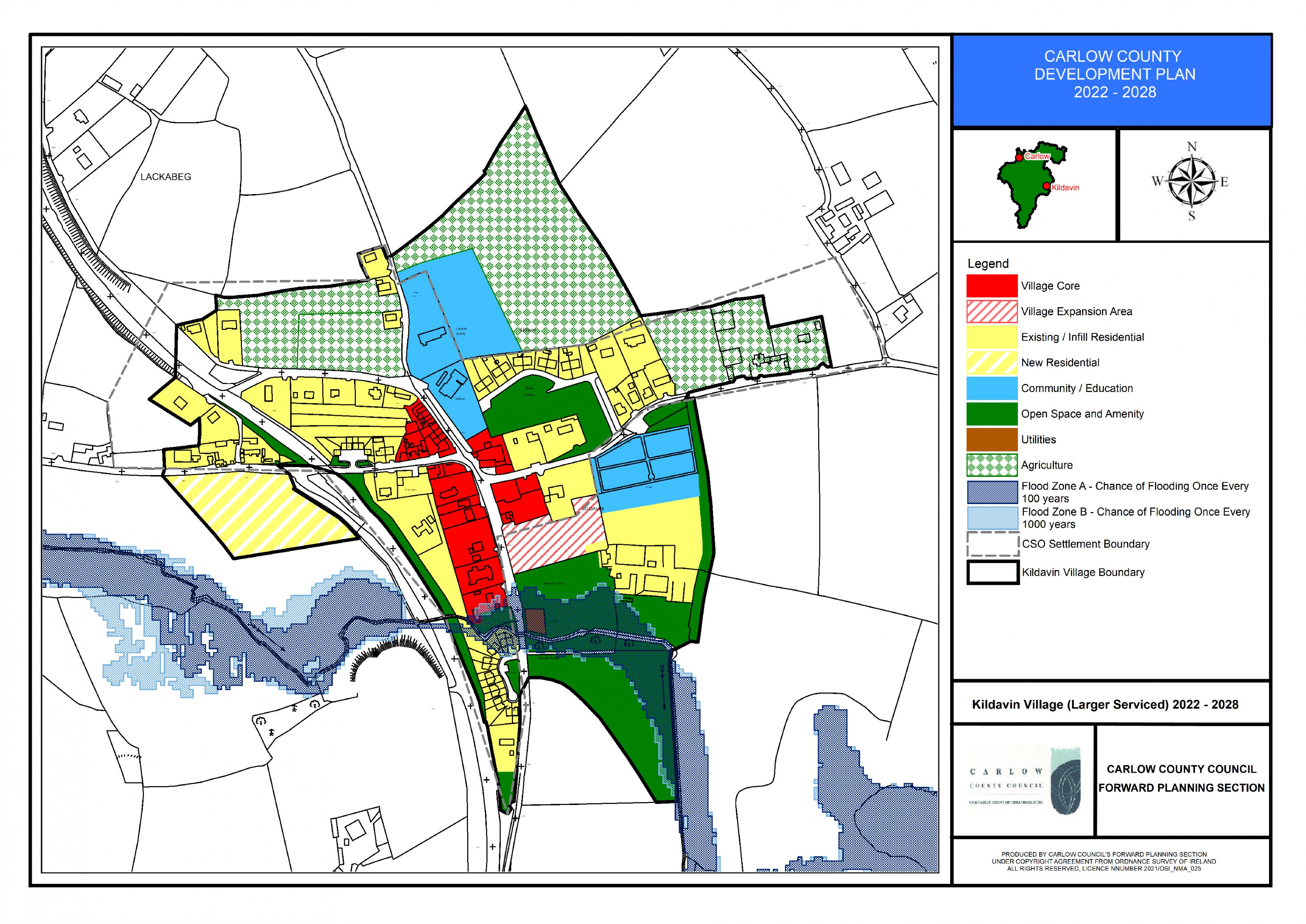
Kildavin Land Use Zoning Map
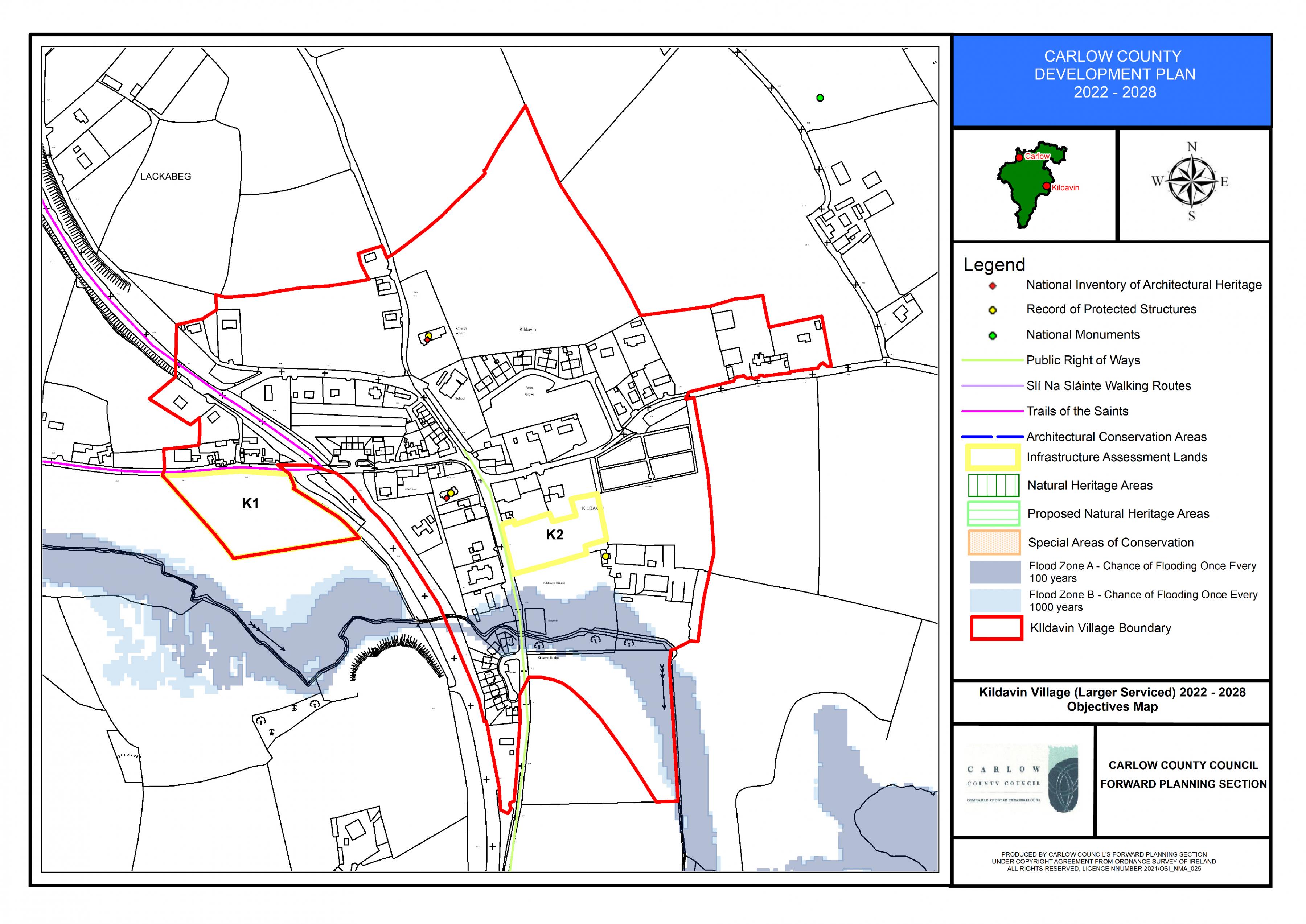
Kildavin Objectives Map
15.4.8 Tinryland Village Plan
Overall Objective
To promote Tinryland Village as a settlement with a strong village character, recreational and social facilities and employment opportunities, to support the improvement of physical infrastructure including wastewater infrastructure and local services and to support growth of the local community to sustainable levels in accordance with the provisions of the Core Strategy and subject to environmental carrying capacity constraints.
Tinryland – Policies
It is the policy of the Council to:
Physical Infrastructure
| TY. P1: | Ensure that future development will be subject to the availability and adequate provision of the necessary physical infrastructure and specifically subject to the upgrading of the existing sewage plant to a level that can accommodate future development and population increases. Detached one-off dwellings on individual effluent treatment systems may be considered in limited circumstances pending upgrade of the effluent treatment plant. |
Consolidate Village Form
| TY. P2: | Consolidate the village form and built fabric in and around the historic village centre and village expansion area , in order to maximise the existing services and historic investment in the village and create a sustainable village environment. |
| TY. P3: | Seek the reuse where possible of brownfield lands, underutilised buildings / out buildings within the village boundary where same would make a positive contribution in maintaining the character of the settlement. |
Village Design
| TY. P4: | Seek to ensure that all development proposals have regard to the character, form and scale of the existing village and comprises of a high-quality design which will make a positive contribution to the character of the area. The proposed design shall be informed by the principles contained in Chapter 12 and shall emerge from careful analysis of the site location, surrounding context and the specific characteristics of the site itself. Specific features that contribute to the character of an area e.g. trees , hedgerows, stone walls etc shall be carefully retained and integrated into the proposed design. |
Placemaking
| TY. P5: | Protect and enhance the unique village character and strengthen the sense of place of the locality by linking and integrating it with future development proposals in design, form and character. |
Infill Development and Alternative to One-off Houses
| TY. P6: | Encourage gap infill development within the village boundaries in order to consolidate the village form. These developments shall act as an alternative to unsustainable ribbon development and one-off house located along approach roads to the village. |
| TY. P7: |
Consider a maximum of 3 number residential units on individual treatment systems on lands zoned new residential immediately to the south of Dun na Ri unless public wastewater infrastructure upgrade is made available during the period of this plan. |
Natural Amenities
| TY. P8: | Protect and enhance the natural/rural amenities and cultural heritage in and surrounding the village. |
| TY. P9: | To promote the retention of hedgerows as the traditional boundary form which is a characteristic of the village. These should be incorporated in future development proposals. |
| TY. P10: | Encourage the preservation of significant trees and groupings of trees within the village in order to retain the natural screening in the village. |
| TY. P11: | Screen future village developments from the surrounding countryside through provision of adequate landscaping, hedgerows and maintaining the rural character of the village. |
Social and Recreational Amenities
| TY. P12: | Promote the improvement and consolidation of existing social and recreational infrastructure within appropriately designated areas in the village. |
Educational Facilities
| TY. P13: | Support the expansion of existing educational facilities within Tinryland and to promote the provision of childcare facilities to meet local demand. |
Built Heritage
| TY. P14: |
Support the retention of buildings with architectural merit, significant architectural features, historic /heritage structures and archaeological sites that contribute to the village character and setting such as:
|
Entrances and Gateways to Village
| TY. P15: | Promote the continued enhancement of defined entrances to Tinryland village and strengthen the sense of arrival when entering the village e.g landscaped pocket parks/amenities. |
Roads and Footpaths
| TY. P16: | Assess the need for improved roads, footpaths and improved permeability in relation to existing and future projected traffic generation in the village and give due consideration to the need to establish a safe and quality village environment and village character. |
| TY. P17: | Seek to ensure that strong linkages to the village core are provided and that new development addresses connectivity to the core of the settlement, community / service facilities with the provision of footpaths/ cycleways, where deemed appropriate. |
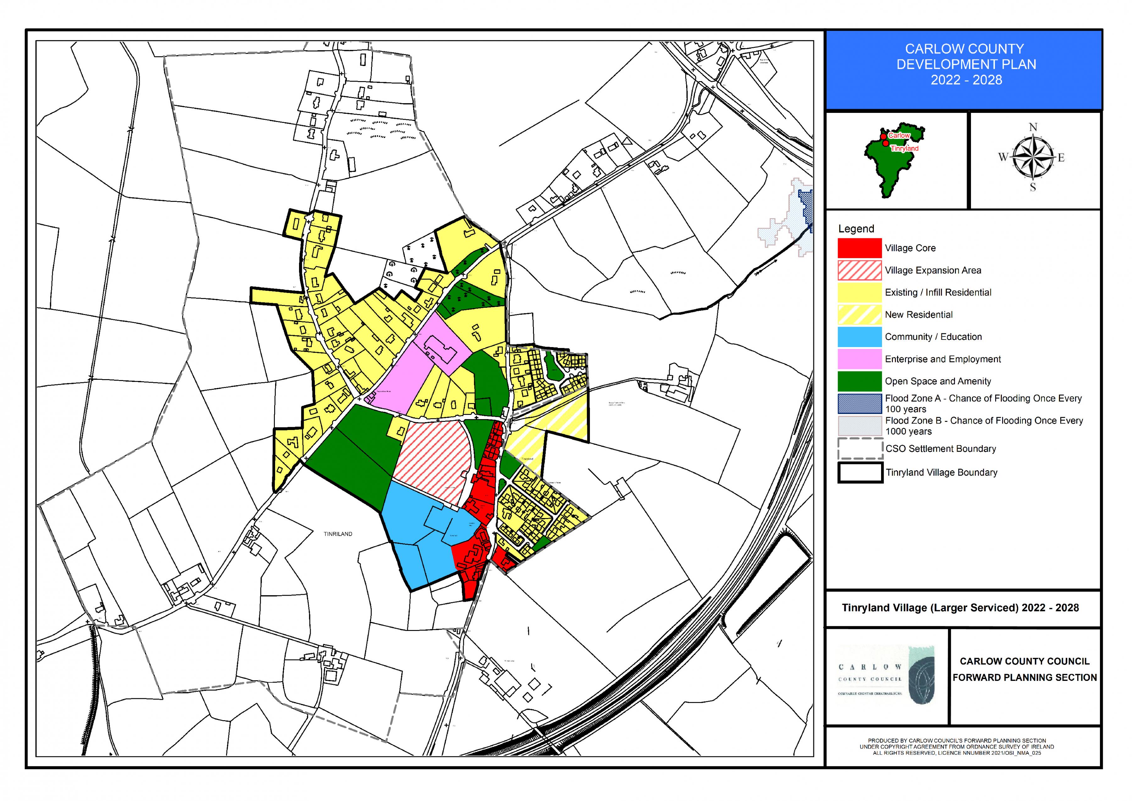
Tinryland Land Use Zoning Map
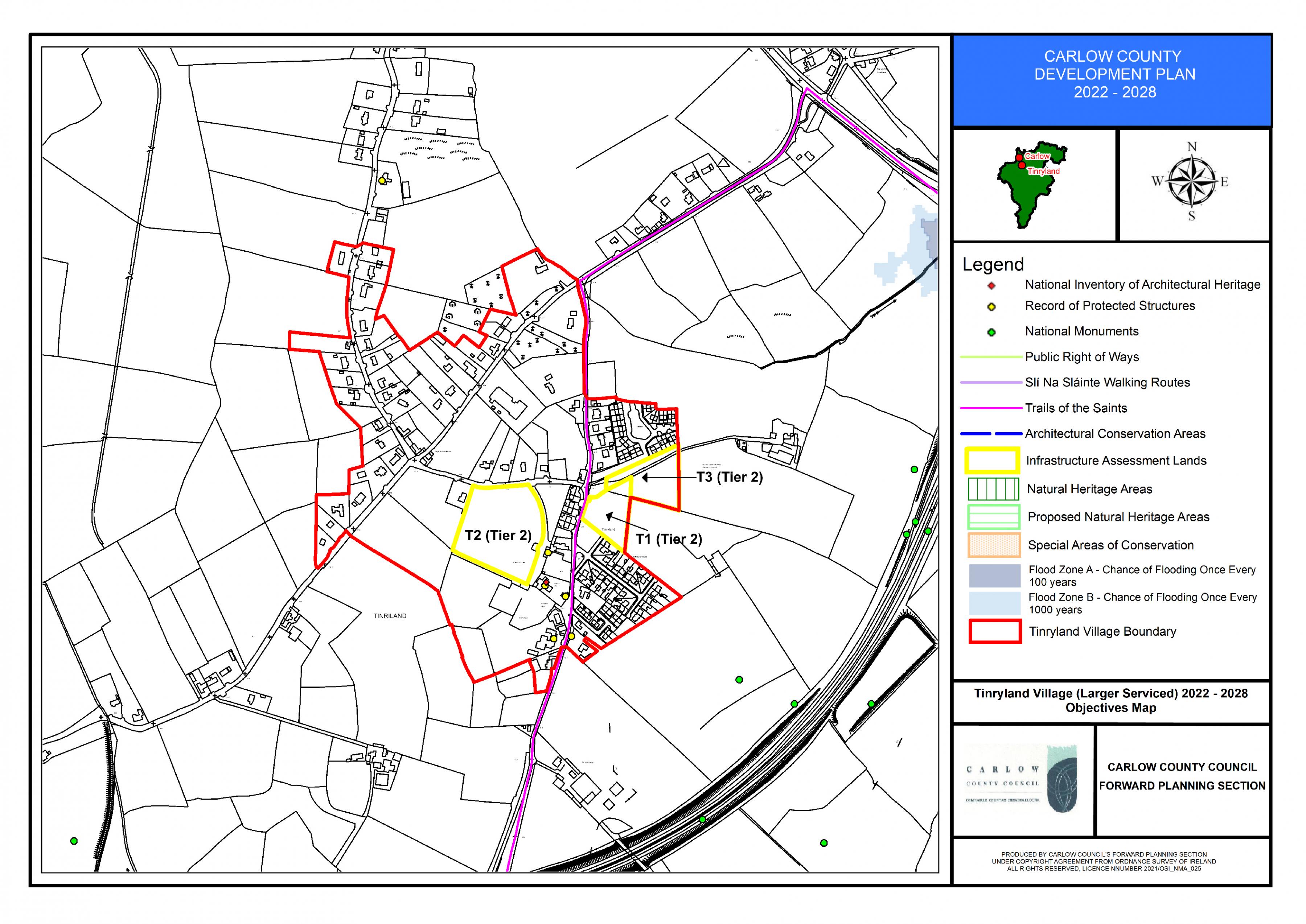
Tinryland Objectives Map
- 1- While Kildavin has a population of 186 in 2016 Census it is considered that the urban structure, level of services and community facilities and level of services provided to a thriving agricultural hinterland are of such a scale that warrant its designation as a larger serviced village.