Chapter 16: Development Management Standards
16.0 Introduction
Development management is the statutory process undertaken in the assessment of planning applications. The purpose of this chapter is to set out the development standards and criteria that will be applied as relevant, in the assessment of planning applications for development in the County.
This chapter should be read in conjunction with other relevant chapters in this Plan and Guidelines issued under Section 28 of the Planning and Development Act, 2000 (as amended).
The fundamental aim is to achieve high standards in design and to build sustainable, healthy communities where people can enjoy a high quality of life. The importance of universal equality of access and inclusive design within all aspects of the built environment is recognised by the Council.
16.1 General Advice for All Developments
16.1.1 Pre-planning Consultations
Pre-planning consultations are facilitated and encouraged by the Planning Authority prior to the making of a formal planning application in accordance with Section 247 of the Planning and Development Act 2000 (as amended). Meetings are facilitated by appointment following receipt of preplanning application form and accompanying details. Following the meeting a minute of the advice provided will be made available to the applicant / agent as appropriate. There is currently no statutory fee for pre-planning meetings (Note: this may change subject to future amendments of relevant planning legislation).
16.2 Environmental Assessments
16.2.1 Appropriate Assessments
Under Article 6 of the Habitats Directive there is a requirement to establish whether, in relation to Plans and Projects, Appropriate Assessment (AA) is required. If, following screening, it is considered that AA is required, then the proponent of the Plan or Project must prepare a Natura Impact Statement. All projects and plans arising from this Plan1 will be screened for the need to undertake Appropriate Assessment under Article 6 of the Habitats Directive. A plan or project will only be authorised after the competent authority has ascertained, based on scientific evidence, Screening for Appropriate Assessment, and subsequent Appropriate Assessment where necessary, that:
- The plan or project will not give rise to significant adverse direct, indirect or secondary effects on the integrity of any European site (either individually or in combination with other plans or projects); or
- The plan or project will have significant adverse effects on the integrity of any European site (that does not host a priority natural habitat type/and or a priority species) but there are no alternative solutions and the plan or project must nevertheless be carried out for imperative reasons of overriding public interest, including those of a social or economic nature. In this case, it will be a requirement to follow procedures set out in legislation and agree and undertake all compensatory measures necessary to ensure the protection of the overall coherence of Natura 2000; or
- The plan or project will have a significant adverse effect on the integrity of any European site (that hosts a natural habitat type and/or a priority species) but there are no alternative solutions and the plan or project must nevertheless be carried out for imperative reasons for overriding public interest, restricted to reasons of human health or public safety, to beneficial consequences of primary importance for the environment or, further to an opinion from the Commission, to other imperative reasons of overriding public interest. In this case, it will be a requirement to follow procedures set out in legislation and agree and undertake all compensatory measures necessary to ensure the protection of the overall coherence of Natura 2000.
Projects giving rise to adverse effects on the integrity of European sites (cumulatively, directly or indirectly) arising from their size or scale, land take, proximity, resource requirements, emissions (disposal to land, water or air), transportation requirements, duration of construction, operation, decommissioning or from any other effects shall not be permitted on the basis of this plan2.
16.2.2 Environmental Impact Assessment (EIA)
Environmental Impact Assessment (EIA) is a key instrument of EU environmental policy. The primary purpose of the EIA Directive (Directive 2011/92/EU as amended by 2014/52/EU) is to ensure that public and private projects, which are likely to have significant effects on the environment are granted permission only after an assessment of the likely significant environmental effects of those projects has been carried out. Annex I and Annex II of the EIA Directive sets out the list of projects for which EIA is required. The Annex I and Annex II projects have been transposed into Section 5 (Parts 1 and 2) of the Planning and Development Regulations 2001 (as amended). Projects listed in Part 1 of the Planning and Development Regulations 2001 (as amended) require EIA if the stated threshold has been met or exceeded or if no thresholds are set. Part 1 sub-threshold developments require screening in cases where the same class of development is not listed in Part 2 with a lower mandatory threshold. Projects listed in Part 2 also require EIA if the stated threshold has been met or exceeded or if no thresholds are set. Sub-threshold developments listed in Part 2 require screening for EIA.
Environmental Impact Assessment is a process to be undertaken in respect of applications for specified classes of development before a decision in respect of development consent is made. The process involves the preparation of an Environmental Impact Assessment Report (EIAR) by the applicant, consultations with the public, relevant prescribed bodies and any other affected Member States, and an examination and analysis of the EIAR and other relevant information leading to a reasoned conclusion by the competent authority, on the likely significant effects of the proposed development on the environment.
Further guidance on EIA is set out in the ‘Guidelines for Planning Authorities and An Bord Pleanála on carrying out Environmental Impact Assessment’. The Environmental Protection Agency (EPA) published ‘Guidelines on the Information to be contained in Environmental Impact Assessment Reports’ in 2017. (Currently in draft stage).
16.2.3 Strategic Environmental Assessment (SEA)
The SEA process is a procedure that ensures that the environmental implications of decisions are considered before such decisions are made. The SEA was integrated into the preparation of this Plan and the SEA Environmental Report is contained as a separate document accompanying the Plan (Appendix I). Lower levels of decision making and environmental assessment should consider the sensitivities identified in the SEA Environmental Report that accompanies the Plan, including the following:
- Special Areas of Conservation and Special Protection Areas;
- Features of the landscape that provide linkages/connectivity to designated sites (e.g. watercourses, areas of semi-natural habitat such as linear woodlands etc);
- Natural Heritage Areas and proposed Natural Heritage Areas;
- Areas likely to contain a habitat listed in Annex 1 of the Habitats Directive;
- Entries to the Record of Monuments;
- Entries to the Record of Protected Structures;
- Architectural Conservation Areas; and
- Landscape/amenity designations.
Lower tier assessments should examine the need for Maintenance Plans informed by environmental considerations to be prepared and implemented.
16.2.4 Ecological Impact Assessment
An Ecological Impact Assessment (EcIA) may be required to be submitted for any development proposal likely to have a significant impact on existing flora, fauna and wildlife habitats, including rare and threatened plant, animal and bird species. The requirement for an ecological impact assessment will be determined on a case by case basis. Reference should be made to “Guidance for Ecological Impact Assessment in the UK and Ireland, Terrestrial, Freshwater and Coastal (CIEEM, 2019) and any Council Guidance document on EcIA approved during the life of this Plan.
16.2.5 Flood Risk Assessment
Where a risk of flooding may be an issue for a development the Planning Authority will require the submission of a Site-Specific Flood Risk Assessment (FRA). The assessment shall be carried out by a suitably qualified and indemnified professional, shall be appropriate to the scale and nature of the risk to the proposed development and shall consider all sources of flooding. The FRA shall be prepared in accordance with the Planning System and Flood Risk Management - Guidelines for Planning Authorities and forthcoming Council Guidance on Flood Risk Assessment (currently in preparation) and shall address climate change, residual risk, avoidance of contamination of water sources and any proposed site-specific flood management measures.
16.3 Universal Access and Design
The importance of universal equality of access and inclusive design within all aspects of the built environment is recognised by the Council. The Council encourages that all new development proposals be designed in accordance with the best practice standards (Refer Section 8.8.4).
16.4 Sustainable Design
Sustainable design elements should be considered at the initial design stage of the process as these will inform appropriate siting, orientation of buildings(s), height, form, materials, density and overall functionality of the development proposed. Buildings / schemes that are designed to adapt to the potential impacts of climate change in addition to improving energy efficiency are encouraged. Such designs will result in a more resilient and adaptable building stock that will support more sustainable communities and lifestyles. Green infrastructure should be identified at the initial design stage, with proposals incorporated into planning applications that deliver natural amenity areas, permeability and linkages to wider open spaces provided.
16.5 Landscaping
16.5.1 Soft Landscaping
Detailed landscaping proposals shall be included with all applications. This includes a schedule of all planting works to be carried out and a timescale for planting. Trees and hedgerows should be retained where possible and these shall be clearly annotated on the drawings. New planting shall be carried out during the first available planting season following commencement of the development. Any planting, which fails during the first season, shall be replaced in the next planting season with a similar species.
Where feasible, any existing mature trees or hedgerows of value shall be retained. New hedging shall consist of native and local species. Common species include Hornbeam, Holly, Common Hawthorn, Privet, Field Maple, Crab Apple, Elder, Spindle and Willow. The soil condition, exposure and local planting patterns will determine the appropriate species for the area.
New hedges integrate better into the wider landscape character if they are also inter-planted with native deciduous trees that are appropriate to that area in terms of soil type, exposure and local planting patterns. Common native trees include Oak, Ash, Hazel, Birch, Scots Pine, Rowan and Willow.
A condition requiring the lodgement of a financial bond may be included in any grant of permission to ensure the satisfactory landscaping of the site. This bond will be returned upon completion of the landscaping to the site.
16.5.2 Hard Landscaping
Hard landscaping, including paving and street furniture is an important element in defining the character of streets and public open spaces. Materials must be appropriate, durable and of good quality. Careful consideration must be given to the design of hard surfaces such as streets, squares, open spaces, paved areas, footpaths and driveways. Hard landscaping shall have regard to the use of Sustainable Urban Drainage Systems. Hard landscaping proposals for public areas shall be assessed with regard to the principles of the Urban Design Manual Best Practice Guide (DEHLG 2009) as appropriate.
Table 16.1 Native Tree and Shrubs
|
Common name |
Height (max) |
Suitable for public open spaces |
Suitable for streets and confined spaces |
Suitable for tubs, containers and raised beds etc. |
|
Alder |
22m |
Yes |
No |
Yes |
|
Alder Buckthorn |
6m |
Yes |
No |
Yes |
|
Ash |
28m |
Yes |
No |
No |
|
Aspen* |
24m |
Yes |
No |
No |
|
Arbutus (strawberry tree) |
8m |
Yes |
No |
Yes |
|
Bramble |
2m |
No |
No |
No |
|
Broom |
2m |
Yes |
No |
Yes |
|
Burnet Rose |
2m |
Yes |
No |
Yes, but vigorous |
|
Common (or European) Gorse |
2.5m |
Yes |
No |
In a rural setting |
|
Crab Apple |
6m |
Yes |
No |
No |
|
Dog Rose |
2m |
Yes |
No |
Yes |
|
Downy Birch |
18m |
Yes |
Yes |
Yes |
|
Elder |
6m |
In hedge |
No |
No |
|
Guelder Rose |
4.5m |
Yes |
No |
No |
|
Hawthorn |
9m |
Yes |
Yes |
Yes |
|
Hazel |
6m |
Yes |
No |
No |
|
Holly |
15m |
Yes |
Yes |
Yes |
|
Honeysuckle |
Climber |
Yes |
On walls |
No |
|
Ivy |
Climber |
Yes |
Yes |
Yes |
|
Juniper |
6m |
Yes |
No |
No |
|
Pedunculate Oak |
30m |
Yes |
No |
No |
|
Rowan or Mountain Ash |
9m |
Yes |
Yes |
Yes |
|
Scots Pine |
24m |
Yes |
No |
No |
|
Sessile Oak |
30m |
Yes |
No |
No |
|
Silver Birch |
18m |
Yes |
Yes |
Yes |
|
Sloe, Blackthorn |
3m |
Yes |
No |
No |
|
Spindle |
7.5m |
Yes |
No |
No |
|
Whitebeam spp. |
12 |
Yes |
Yes |
Yes |
|
Wild Cherry |
15m |
Yes |
Yes |
Yes |
|
Wild Privet |
3m |
Yes |
Yes |
Yes |
|
Willow spp.* |
6m |
Some |
No |
No |
|
Wych Elm |
30m |
Yes |
|
No |
|
Yew |
14m |
Yes |
No |
Yes |
*Not suitable near buildings or services
16.6 Site Coverage
Site coverage standards are intended to avoid the adverse effects of over-development.
Site Coverage comprises the total area of ground covered by buildings divided by total ground area within the site curtilage
The maximum site coverage shall be 50% for residential development, 75% for industrial uses, 60% for other employment uses and 66% for retail and commercial development. Within town centre zones, the maximum site coverage shall in general be 80% for all development.
These particular site coverage standards shall be acceptable only where consistent with other standards such as open space requirements, car parking, plot ratio, building lines and building heights, fire safety and building regulations together with the amenity of adjoining dwellings / properties. In considering applications for redevelopment of existing sites, due regard will be had to the established site coverage.
16.7 Plot Ratio
The purpose of plot ratio standards is to prevent the adverse effects of over-development on the layout and amenity of buildings and also to ensure an adequate sense of enclosure and the efficient and sustainable use of serviced land.
Plot Ratio = Gross building floor area divided by the Gross site area.
The gross floor area is the sum of all floorspace within the external walls of the buildings, excluding plant, tank rooms and car parking areas. The gross site area comprises all land within the curtilage of the site. Plot ratio standards shall be as follows:
|
Plot Ratio Standards |
|
|---|---|
|
Location |
Plot Ratio |
|
Town Centre / Brownfield |
1.0-2.0 |
|
Inner Suburban |
0.5-1.0 |
|
Outer Suburban |
0.35-0.5 |
Table 16.2 Plot Ratio Standards
In considering applications for redevelopment of existing sites, due regard will be had to the established plot ratio.
16.8 Residential Development
This section sets out the standards that will apply to developments relating to residential / mixed use development in towns and villages.
The following guidance documents should be consulted (unless otherwise updated) when designing a residential development:
- The Guidelines on Quality Housing for Sustainable Communities, DEHLG, (2007);
- The Guidelines for Planning Authorities on Sustainable Residential Development in Urban Areas, DEHLG, (2009);
- Urban Design Manual: A Best Practice Guide, DEHLG, (2009);
- Sustainable Urban Housing: Design Standards for New Apartments, DHPLG, (2018);
- Urban Development and Building Height Guidelines, DHPLG, (2018);
- The Design Manual for Urban Roads and Streets, DTTAS and DECLG, (2013 and updated in 2019);
- Permeability Best Practice Guide, NTA, (2015); and
- Recommendations for Site Development Works for Housing Areas.
Chapter 13, Rural Design Guide shall be referenced for one-off rural dwellings, extensions to rural dwellings, restoration and re-use.
16.8.1 Urban Design
Good urban design is fundamental to creating and shaping vibrant urban places. The key principles of good urban design are outlined in Chapter 12 Urban Design and Regeneration.
A detailed design statement shall be submitted with all planning applications for residential development on urban sites in excess of 0.2 hectares or for more than 10 residential units. The design statement shall:
- Describe the design concept;
- Demonstrate compliance with Chapter 12 and design criteria as contained in the ‘Urban Design Manual – A Best Practice Guide’;
- Set out how the development complies with the policies and objectives of the Development Plan, Local Area Plan, Regeneration / Public Realm Strategy etc as maybe appropriate.
- Provide site photographs;
- Include an open space/ landscape / green infrastructure strategy; and
- Set out how energy efficiency measures have been incorporated into the project.
16.8.2 Density
Indicative density levels are set out in Chapter 3 - Section 3.8.
| Town Centre/Village Core | Edge of Centre | |
|---|---|---|
| Carlow Town | >35ha | 25-30*ha |
|
Tullow Muine Bheag |
<30ha | 20-30*ha |
| Smaller Towns | 25-30ha | 20-25ha** |
| Villages | 20-25ha | 10-20ha |
* Densities in excess of 30 units per ha may be considered on appropriate edge of centre sites in Carlow, Tullow and Muine Bheag subject to high quality design and layout.
** Lower density residential development and serviced sites will be facilitated on appropriate sites within smaller towns and villages within the rural area in compliance with the programme for ‘new homes in small towns and villages’ NPO 18(b) .
Local Area Plans will identify density targets for particular sites as appropriate. Higher densities must ensure a balance between reasonable protection of existing residential amenities and the established character of these areas. (See Table 3.3, Chapter 3 for indicative densities).
The Council will support and encourage as part of the pre-planning process the provision of an appropriate level of serviced sites as part of any residential scheme on zoned land in towns and villages throughout the County to attract persons to build their own homes in order to maintain the viability of these settlements and provide an appropriate alternative to one-off housing in the rural countryside.
16.8.3 Buildings of Increased Height
The Planning Authority may consider buildings of increased height in accordance with The Urban Development and Building Heights Guidelines published in 2018 in circumstances where the site / development is:
- Appropriately located in central areas of larger towns close to public transport or on strategic lands proximate to the town centre.
- Comprise high quality design making a positive contribution in the streetscape, strengthening the sense of place while respecting and responding to the character of the area.
- Designed to protect and enhance the existing streetscape and heritage characteristics of an area. Proposals should not disrupt or negatively impact on the historic areas of towns or intrude on important views.
16.8.4 Layout
The layout of new residential development should be designed to achieve the following:
- A strong sense of identity and a sense of place. New developments should take full account of the characteristics of the site, the views and vistas to and from the site and the surrounding areas. Natural boundaries, trees and hedgerows should where possible be incorporated into proposed public or private open space and boundaries.
- Permeable layouts, with multiple connections to adjoining sites / estates for pedestrians and cyclists. Gated developments will generally not be permitted, as they do not promote permeability or integration with the surrounding neighbourhood.
- Priority in the order of pedestrian - cyclist -public transport -car.
- A suitable mix and typology of residential units.
- Delivery of high quality accessible open space, public realm and landscaping.
- Active frontage and supervised spaces including dual frontage dwellings to ensure active and passive surveillance over street frontages, open spaces etc.
- High quality materials and planting.
16.8.5 Residential Amenity
In terms of residential amenity proposed residential schemes shall be designed having regard to the following;
- The need to protect amenities of existing residents in the locality of the subject development.
- A minimum 22m separation between directly opposing first floor habitable rooms in residential properties shall generally be observed.
- A minimum of 2.5m distance between detached and semi-detached dwellings shall generally be provided.
- Adequate provision shall be made for the storage (3 wheelie bins) and collection of waste materials. Terraced / townhouses shall provide appropriately located screened bin storage locations which shall be identified in the planning application. Where communal bin facilities are being provided they shall be conveniently located, screened and well ventilated.
- Minimise overshadowing by applying the recommendations of ‘Site Layout Planning for Daylight and Sunlight: A Guide to Good Practice’ – Second Edition (B.R.E.).
- Car parking for detached and semi-detached housing should be within the house site and not on the public road. Car parking for apartments and terraced housing should be in informal groups overlooked by housing units. The visual impact of large areas of car parking should be reduced by the judicious use of screen planting, low walls and the use of textured or coloured paving for parking bays.
16.8.6 Boundary Treatments
Proposed boundary treatments shall have regard to the following:
- High quality boundary treatments are generally required to enclose private open space. A 1.8m – 2m high wall of solid block, capped and plastered on both sides, is generally acceptable. The Council will consider alternative boundary treatments on their merits. All boundaries shall be of high quality solid construction with no gaps. Timber post and panel fencing is not permitted.
- Concrete post and base with timber infill panel fencing will be considered for the side boundaries between rear gardens, provided a 2m length of 1.8-2m high block wall, capped and plastered, is provided for the initial 2m from the rear building line of the house.
- Two-metre-high screen walls should be provided between all areas of public space and rear garden boundaries. Where screen solid block walls along the edge of public areas are proposed (e.g. open space or footpaths) they should be suitably rendered and capped. Proposals for planting along the public side of the wall shall be included on a landscaping plan. An additional inner grass verge shall be provided at the footpath to facilitate this if necessary.
- Walls or fences where located to the front boundary shall be at least 0.5m high and in keeping with the house design and to a uniform scheme design.
16.8.7 Public Open Space
The provision of accessible open space is a key part of the provision of high-quality green infrastructure for communities. Public open space must be carefully designed as an integral part of the layout of all residential schemes / mixed schemes and should be addressed at the initial design stages.
All applications for residential developments shall;
- Provide public open space on greenfield sites equating to a minimum of 15% of the total site area, a minimum 10% on large infill sites / brownfield sites and 20% on institutional lands. The areas of public open space shall be clearly identified on the site layout/ landscaping plan.
- Include a landscape plan and illustrate how existing green infrastructure and opportunities to create more linkages have informed and been incorporated into the development layout.
- Natural features e.g. trees, hedgerows and wetlands shall be retained, protected and incorporated into public open space areas.
- Public open spaces should be appropriately located, passively overlooked by as many dwellings as possible and easily accessible to all residents, providing for both passive and active uses. Narrow tracts of land (less than 10m) are not acceptable.
- Natural features that promote children’s play shall be incorporated into the design.
- On larger sites, areas should be identified for a hierarchy of uses e.g. casual ‘pocket parks’ for smaller children to play, informal kick about areas, areas for passive amenity etc.
In developments where the standard of open space is of a high quality due to its location, functionality and any additional detailing proposed a reduction in the rate of open space maybe acceptable. Any reduction will be assessed on a case by case basis and is at the discretion of the Planning Authority.
For schemes of <8 dwellings per hectare, a relaxation of the standards may also apply where the provision of space within the curtilages of the dwellings is above the minimum requirements.
16.8.8 Private Open Space
All houses should have an appropriate and useable area of private open space to the rear of the dwelling. The minimum area of private open space to be provided is set out in Table 16.3. Exceptions may be only considered in relation to the redevelopment of inner urban infill where there is a need to protect the established pattern of streets and spaces and the redevelopment of brownfield / regeneration sites where a focus should be on design led and performance-based outcomes rather than specific absolute requirements in all cases. Flexibility will only be permissible in response to well-designed development proposals.
|
House Type |
Minimum Area of Private Open Space Required |
|---|---|
|
One/two bedroom |
55m2 |
|
Three bedrooms |
60m2 |
|
Four bedrooms or more |
75m2 |
Table 16.3: Minimum Private Open Space Standards for Houses
Housing developments which provide private open space at the minimum standard throughout will be discouraged.
16.8.9 Naming of Developments
The naming of new residential development should reflect local heritage and historical context of its siting as far as possible such as local names which reflect the landscape, its features, culture or history of the area in which the development is located. Names shall include the use of the Irish language. The naming of residential developments shall be approved by the Planning Authority prior to the launching of any advertising campaign for a development.
16.8.10 Bonds and Taking in Charge
To ensure the satisfactory completion of development works (roads, footpaths, surface water drainage, car parks, public lighting, open space, landscaping, including the protection of trees) undertaken by private developers a cash deposit or a bond from an insurance company or other financial institution acceptable to the Planning Authority will be required. This bond or cash lodgement may be sequestered in part or in its entirety at the discretion of the Planning Authority where the development has not been satisfactorily completed. The amount of such bond or cash lodgement will be determined by the Planning Authority.
Residential developments completed to a standard that is compliant with the planning permission granted and on receipt of a request will be taken in charge in accordance with Carlow County Council’s Taking in Charge Policy and the provisions of the Planning and Development Act 2000 (as amended) and the Roads Act 1993. The Council encourages the completion of infrastructure at incomplete housing estates in order that such estates may be taken in charge by Carlow County Council
Where management companies are required for apartment schemes, a properly constituted management company shall be established for the purposes of maintaining public lighting, roads, parking areas, services, open spaces and public areas in apartment schemes.
16.8.11 Apartments
The suitability of a specific site for the development of apartments will be considered on a case-by-case basis and will take account of the location, the prevailing pattern of development of the area, the proximity to local amenities and services, and the scale of development proposed.
Apartments shall generally be located in central urban areas within a reasonable walking distance (up to 15 minutes) of town centres and public transport. Outside of the central areas of towns, apartments may form a smaller element of a residential scheme.
Design Standards for New Apartments
The Design Standards for New Apartments (2018) set out the minimum design criteria for apartment developments. All applications for apartments are required to demonstrate at a minimum compliance with these Guidelines and the Specific Planning Policy Requirements (unless otherwise updated). Details of the following design criteria are set out in the Guidelines:
- Location;
- Apartment mix;
- Internal space and floor areas;
- Dual aspect ratios;
- Floor to ceiling height;
- Apartments to stair/lift core ratios;
- Storage spaces;
- Amenity spaces; and
- Car Parking.
Requirements of the Guidelines include:
- Apartment developments may include up to 50% one-bedroom or studio type units (with no more than 20-25% of the total proposed development as studios) and there shall be no minimum requirement for apartments with three or more bedrooms (Ref SPPR 1).
- For all building refurbishment schemes on sites of any size, or urban infill schemes on sites of up to 0.25ha:
- Where up to 9 residential units are proposed, notwithstanding SPPR 1, there shall be no restriction on dwelling mix, provided no more than 50% of the development (i.e. up to 4 units) comprises studio-type units;
- Where between 10 to 49 residential units are proposed, the flexible dwelling mix provision for the first 9 units may be carried forward and the parameters set out in SPPR 1, shall apply from the 10th residential unit to the 49th;
- For schemes of 50 or more units, SPPR 1 shall apply to the entire development. (Ref: SPPR 2).
- Minimum floor areas, private open space and storage provision are outlined in Table 16.4. For apartment schemes of 10 or more units, the majority of apartments must exceed the minimum floor area standard for any combination of the relevant 1, 2 or 3-bedroom unit types, by a minimum of 10%. (Ref: SPPR 3).
- (i) A minimum of 33% of dual aspect units will be required in more central and accessible urban locations, where it is necessary to achieve a quality design in response to the subject site characteristics and ensure good street frontage where appropriate.
(ii) In suburban or intermediate locations it is an objective that there shall generally be a minimum of 50% dual aspect apartments in a single scheme.
(iii) For building refurbishment schemes on sites of any size or urban infill schemes on sites of up to 0.25ha , planning authorities may exercise further discretion to consider dual aspect unit provision at a level lower than the 33% minimum outlined above on a case-by-case basis, but subject to the achievement of overall high design quality in other aspects. (Ref: SPPR 4).
- Ground level apartment floor to ceiling heights shall be a minimum of 2.7m and shall be increased in certain circumstances, particularly where necessary to facilitate a future change of use to a commercial use. For building refurbishment schemes on sites of any size or urban infill schemes on sites of up to 0.25ha, the planning authority may exercise discretion on a case-by-case basis, subject to overall design quality; (Ref: SPPR 5).
- A maximum of 12 apartments per floor per core may be provided in apartment schemes. This maximum provision may be increased for building refurbishment schemes on sites of any size or urban infill schemes on sites of up to 0.25ha, subject to overall design quality and compliance with building regulations; (Ref: SPPR 6).
- Private open space shall primarily be accessible from the main living area in the form of balconies / terraces; and
- Communal amenity space shall be provided to service the entire residential scheme.
|
Apartment Unit Type |
Floor Area |
Storage |
Private Open Space |
|---|---|---|---|
|
Studio |
37m2 |
3m2 |
4m2 |
|
One bedroom |
45m2 |
3m2 |
5m2 |
|
Two bedroom (3 person) |
63m2 |
5m2 |
6m2 |
|
Two bedroom (4 person) |
73m2 |
6m2 |
7m2 |
|
Three bedroom |
90m2 |
9m2 |
9m2 |
Table 16.4 Standards for Apartments
All applications for apartment(s) shall include a schedule that provides the following information:
- The number and type of apartments and associated individual unit floor areas;
- Details of apartment aspect (dual or single) and orientation;
- Principal dimensions of each room as well as the aggregate floor areas;
- Details of internal and external storage space;
- Quantum of proposed private amenity space;
- Communal open space; and
- Storage and collection of waste materials.
16.8.12 Upper Floor / Living over the Shop
Proposals for the residential conversion of upper floors of retail and commercial premises will be favourably considered where such proposals protect the historic fabric (if relevant) and promote the vibrancy and vitality of the town / village centre. In recognising the need to protect the historic fabric of our towns/villages while encouraging people to live in upper floors of retail/ commercial premises, it is acknowledged that it is not always possible or practical to fully achieve current residential standards. In this regard, at the discretion of the Planning Authority and subject to protecting residential amenity, a reduction in open space and car parking standards maybe considered for ‘living over the shop’ accommodation proposals particularly in central locations. Minimum standards in relation to overall floor areas, storage space and natural light must be complied with to protect residential amenity. In the case of residential accommodation over non-residential uses, a separate access should be provided for the upper floor accommodation, proper sound proofing, ventilation and storage must be built into the design of the building.
16.8.13 Extensions to Dwellings
The design and layout of extensions shall
have regard to the character of the existing dwelling, the nature of the surrounding area and the amenities of adjoining properties, particularly as regards sunlight, daylight and privacy. The following basic principles shall be applied:
- The extension should be sensitive to the existing dwelling in its form, scale and appearance and should not adversely distort the scale or mass of the structure or adjoining properties. Contemporary and innovative designs that would make a positive contribution to the local streetscape will be considered on their merits.
- In rural areas, the design of extensions should also have regard to the Key Principles set out in Chapter 13 Rural Design Guide.
- The extension should not provide for new opportunities for overlooking of the private area of an adjacent residence where no such overlooking previously existed.
- In an existing developed area, where a degree of overlooking is already present, the new extension must not significantly increase overlooking possibilities.
- New extensions should not overshadow adjacent dwellings to the degree that there is a significant decrease in daylight or sunlight entering into the house. Daylight and sunlight assessments maybe required. This shall be carried out in accordance with the recommendations of the BRE Guidance ‘Site Layout Planning for Daylight and Sunlight’: A Guide to Good Practice (2011).
- In all cases a minimum private rear garden area must be retained, unless located on a constrained inner urban town centre site, where the development would be appropriate in the context of preserving the historic fabric and maintaining vibrancy of the town centre.
- Ability to provide adequate car parking within the curtilage of the site.
- If the property is serviced by an individual on-site wastewater treatment system this system must have the capacity to accommodate any additional loading in accordance with the EPA Code of Practice for Wastewater Treatment and Disposal Systems Serving Single Houses. This may result in the requirement for existing systems to be upgraded to the current standards.
16.8.14 Family Flats
All applications for family flat development shall comply with the following criteria:
- A bona-fide need is demonstrated for the unit by an immediate family member;
- The flat shall form an integral part of the structure of the main house with provision for direct internal access to the remainder of the house.
- The flat shall be modest in size (not exceeding 50m2).
- There shall be no permanent subdivision of the garden;
- The unit shall not be sold or let as an independent unit and shall remain in the same ownership as the main dwelling on site.
- The design shall ensure that the flat can easily fully revert to being part of the original house when no longer occupied by family member(s).
- If the property is serviced by an individual on-site wastewater treatment system this system must have the capacity to accommodate any additional loading in accordance with he EPA Code of Practice for Wastewater Treatment and Disposal Systems Serving Single Houses 2021. This may result in the requirement for existing systems to be upgraded to the current standards.
16.8.15 Student Accommodation
Applications for purpose-built student housing will require a statement that outlines the proposed terms of occupation (e.g. term-time for students and short let during academic holiday period), details of proposed management structure and the design (dwelling mix, open space provision, car parking provision, etc). The proposal shall demonstrate that the design is suitable to meet the accommodation needs of the intended occupants and would not impact on the amenities of the area. The Planning Authority will exercise flexibility with regard to the application of Development Plan standards where it is demonstrated that the proposal adequately addresses the needs of the intended future occupants.
16.8.16 Amendments to Approved Residential Development
Where an application is made for changes to the design or layout of elements of a residential scheme, the duration of the permission shall be linked by condition to the parent permission. This is to ensure compliance with the Core Strategy and implementation of residential schemes in an orderly and integrated fashion.
16.9 Enterprise and Employment
All employment related developments are required to be developed to a high standard. This will assist in creating an attractive environment for people to work and businesses to invest.
16.9.1 Employment Uses
All planning applications for industrial, commercial and business development shall be of a high design quality and accompanied by the following:
- Details of the nature and scale of the proposed operation, to include opening hours and anticipated traffic levels;
- Availability of adequate services to serve the development;
- Proposals for the safe storage and disposal of waste in a manner which is visually and environmentally acceptable. Storage areas should be screened from public view and generally be confined to the rear of the premises;
- Compatibility of existing adjacent land uses with the proposed development, and mitigation measures to preserve and protect the amenity of the adjacent uses, should this be necessary;
- Availability of adequate sight lines;
- Standards and safe road access for anticipated levels of traffic;
- Adequate parking and circulation areas within the curtilage of the proposed development, unless otherwise agreed with the Planning Authority;
- Advertising signage shall be detailed and shall be sympathetic in size, scale, design, materials and colour with the surrounding landscape / streetscape; and
- Lighting should be unobtrusive and should not adversely affect traffic safety on adjacent roads.
16.9.2 Industrial, Office, Warehousing and Business Parks
In addition to the above, the planning authority in assessing planning applications, will require:
- Conformity with the land use zoning objectives and / or other policy provisions as contained in Chapter 4 Enterprise and Employment and / or Chapter 14 Rural Development.
- A Masterplan for any expansive areas of undeveloped employment lands to facilitate co-ordinated development.
- High Quality Design shall be provided incorporating where appropriate a suitable mix of finishes and architectural treatment. Landmark buildings of notable design will be encouraged at strategic locations in business parks. For all significant employment developments comprising schemes with a gross floor area of 1000 sq.m. and above (or otherwise as required by the Planning Authority), a Design Statement will be required.
- The layout shall be of a high quality that includes design principles including connectivity and permeability with high quality landscaping. Building lines shall generally respect the existing established pattern. Undeveloped areas shall provide a minimum of 15m setback along principal road frontages with appropriate (min. 5m depth) landscaping to the fore of the buildings.
- Retention and enhancement, where possible, of existing natural features such as hedgerows and associated ditches and streams offers the potential to incorporate sustainable drainage measures and retain wildlife corridors. The addition of surface water attenuation ponds, green roofs and living walls offers significant opportunities for wildlife while providing a high-quality environment for employees.
- Proposals to protect residential amenity of any adjoining properties. Reduced heights and / or significant landscaping proposals maybe required together with measures to mitigate noise and lighting emissions.
- Energy efficiency and overall sustainability of the development.
- Workplace Travel Plan will be required for a large-scale employment generating development that gives rise to significant demand in trips.
- Adequate parking, circulation and access arrangements shall be provided using permeable materials. Preparation of an ‘auto-track’ analysis maybe required to demonstrate adequate areas for delivery vehicles.
- Loading and open storage areas shall be visually unobtrusive from public roadways and screened or preferably located behind the building line.
- Multiple unit developments shall implement ordered naming and signage schemes to avoid visual clutter.
16.9.3 Home Based Economic Activity
Proposals for home based economic activities will be considered on a case-by-case basis. These activities shall be ancillary to the primary use of the property as residential accommodation. The nature of the use proposed should not have any adverse impacts on the amenities of neighbouring dwellings. Applications shall be accompanied by the following details:
- Type of business proposed;
- The nature and extent of the work;
- Reason for its location (e.g. justification on why it is not proposed within settlement centre, etc.);
- Anticipated levels of traffic generated by the proposal, accessibility, and car-parking;
- The effects on the amenities of the adjoining occupiers particularly in relation to hours of work, noise and general disturbance;
- Whether the proposal requires delivery/shipment of goods and details of same;
- Storage and collection of waste. (Materials used or goods manufactured, serviced or repaired in the home-based business must be stored within a building).
- No goods manufactured, serviced or repaired should be displayed so that they are visible from outside the site.
A temporary permission may be granted to enable the Planning Authority to monitor the impact of the development in the area.
16.9.4 Retail Development
Retailing has an important role in the economy of County Carlow. Chapter 4 Enterprise and Employment and Appendix V Retail Strategy establishes capacity, a vision, policies and actions for retailing in County Carlow in line with the requirements of the Retail Planning Guidelines, Guidelines for Planning Authorities, 2012. Retail development must be appropriately located in line with the nature and scale of the settlement and be of a high-quality design. It is acknowledged that successful retailing will be heavily reliant on being located in quality urban settings.
In the assessment of retail planning applications, the following considerations will apply:
- High quality design making a positive contribution to the area in which it is located. Design statements may be required for larger scale proposals.
- Landscaping and public realm interventions shall enhance the character of the area.
- Loading / unloading, car parking and cycle parking shall be in accordance with Section 16.10.11.
- Incorporation of measures to mitigate impacts on the residential amenity of adjoining properties, e.g. air quality, excessive noise and lighting.
16.9.5 Service Stations
The role of service stations has expanded from the provision of fuel to also providing convenience goods and services. Proposals for new and extended service stations will be carefully considered and will not generally be encouraged within the core retail area of urban centres or in the open countryside outside of towns, villages and rural nodes. The proposed location should also be compatible with surrounding land uses, where safe access can be achieved and there would be no adverse impact created on the amenities of surrounding properties. Applications for service stations shall comply with the following:
- A high standard of overall design, layout and external finishes to ensure an attractive development that integrates with and complements or enhances its surroundings. The safety aspects of circulation (vehicular, pedestrian and cyclists) and parking within the forecourt shall be fully demonstrated.
- Advertising material should be kept to a minimum (single pole / totem sign) and appropriately designed. No lighting shall be installed so as to cause glare or interference to any user of an adjacent public road. The modification of standard corporate designs may be required by the Council in order to reduce the visual impact of the development in sensitive environments. Placement of signage on footpaths, grass verges or any part of the public roadway will not be permitted.
- The retail floor space of the shop shall not exceed 100 sq.m net; where permission is sought for a floor space in excess of 100 sq.m net, the sequential approach to retail development shall apply in accordance with the Retail Planning Guidelines, DECLG (2012) i.e. the retail element of the proposal shall be assessed by the planning authority in the same way as would an application for retail development (without petrol/diesel filling facilities) in the same location.
- Detailed proposals including method of disposal of wastewater from carwash areas, traffic management, surface water outlet and oil interceptors etc. The development shall be designed and operated to avoid adverse effects on existing road drainage in the area.
- Ancillary services e.g. car wash services etc should be sited so as not to result in queueing onto the public road network or negatively impact on neighbouring residential properties.
- Rapid EV charging point(s) should be provided and clearly demarcated with appropriate signage, in collaboration with ESB networks.
16.9.6 Fast Food/ Take Aways
The proliferation of fast food outlets in any area has the potential to cause noise, littering and can detract from the amenities of the area. Accordingly, proposals for new or extended outlets will be carefully considered, particularly in locations where a proliferation of such uses already exists. The provision of fast food outlets will have regard to the following:
- The number of such facilities in an area and their cumulative impact in association with the proposed development;
- The need to safeguard the vitality and viability of shopping areas in the town centre and to maintain a suitable mix of retail uses;
- The proximity of such uses to other vulnerable uses, e.g. residences, schools, open space;
- The likely impact on general amenity and residential amenity in terms of noise / disturbance, traffic, parking, litter and fumes. Measures to mitigate potential impacts shall be outlined (e.g. noise mitigation, litter management, location of vents and other external services etc);
- Proposed façade design, the type and degree of any advertising / signage and lighting, and the visual appearance of vents / extractors; and
- Proposed opening hours must be specified.
16.9.7 Shopfronts, Advertising and Signage
The Council will encourage the preservation of authentic, traditional shopfronts and the provision of good quality contemporary designs. The design of shopfronts should reflect the scale and proportions of the existing streetscape. The Council will seek to retain the remaining traditional shopfronts of townscape importance. It should be noted that the replacement of an existing shopfront, or the insertion of a new shopfront requires planning permission and is not considered to constitute exempted development.
Applications for new shopfronts or modifications to existing shopfronts shall have regard to the following:
- Detailed plans at a scale of 1:50. Such plans shall include details regarding the design, colour and detailing with regard to signage (including window adhesive signage), advertising and lighting.
- The use of garish colour should be avoided.
- All signage must be compatible with the existing streetscape. Timber, stone, glass and steel are preferred materials.
- Contemporary shopfronts will be encouraged provided they are designed to traditional principles of scale, proportion and detailing.
- The appearance and proportions of the original shopfront shall be retained.
- The twin elements of a fascia board (to carry names and advertising) and pilasters (to frame and delineate the shopfront boundary) shall be provided in all cases.
- The design must be approached in an integrated way (relate to the whole facade), including advertising, lighting and other features.
- Colour schemes should co-ordinate with adjoining buildings and shopfronts and should be chosen to enhance the proportions and detailing of the whole building.
- Vertical emphasis and proportions should be kept, and plot divisions should be expressed externally (even if the shop crosses them internally).
- The removal of service wires associated with existing facades will be actively promoted.
The Council will not permit the following:
- The removal of features or alterations to existing shopfronts where they are considered by the Council to be of historical or architectural interest, or of townscape value;
- The enlargement or remodelling to a horizontal emphasis of existing windows above ground floor level;
- The construction of fascias linking two or more buildings / plots which have different architectural identities;
- Internally illuminated fascias or projecting box signs. The use of large areas of undivided glass or the provision of new display windows with a horizontal emphasis;
- The permanent removal of the shopfront and the creation of an opening through which direct trading onto the pavement is carried out;
- The use of standardised brand names, logos, corporate designs as part of shopfront fascia advertising, where it conflicts with the existing streetscape; and
- The use of external roller shutters and their boxes and projecting brand signs on the exterior of shop-fronts.
16.9.8 Roller / Security Shutters
Where security shutters are considered to be essential, e.g. because of the type of business transacted or goods stored, and where the location so indicates, the Council may permit them provided that they meet the following criteria:
- They must be of the open-grille type or timber panelled shutters painted to match the shop-front colour scheme. This will be more favourably considered in place of roller shutters in order to enhance the streetscape.
- Where roller shutters are proposed they must be internal and located behind the display window.
16.9.9 Canopies / Blinds
Where shading of a window display is required, the use of traditional rectangular sun blinds / awnings of the retractable type may be permitted. The erection of plastic or fabric canopies or the ‘Dutch’ type will be discouraged.
16.9.10 Advertising and Sign Posting
Advertising signs, separately, or more particularly in groups, can often cause injury to visual amenities, and can detract from the appearance of an area or a building; this is especially so when they are out of scale and character with their surroundings. Furthermore, they can also be a distraction to road users and frequently result in traffic hazard. The Planning Authority will strictly control all advertising signs in relation to their location, design, scale, materials and function.
Advertising proposals shall outline a demonstrable need and shall be controlled as follows:
- Signs will not be permitted where they interfere with the safety of pedestrians, the safety and free flow of traffic or if they obscure road signs;
- Signs will not be permitted where they have an adverse impact on the streetscape, or the visual amenity of the local area;
- Signs shall be sympathetic in design and colouring, both to the building on which it will be displayed and its surroundings;
- Signs shall not obscure architectural features or details;
- Signs will not be permitted above eaves or parapet levels;
- Traditional painted sign writing or solid block individual lettering will be encouraged as will traditional or wrought iron hanging signs. The use of neon, plastic, PVC, perspex flashing, reflectorised or glitter type signs on the exterior of buildings or where they are located internally but visible from the outside will be prohibited;
- Projecting signs, banners and flagpoles will be restricted in size and number to prevent clutter;
- Temporary hoardings may be approved where they can be used for the screening of building sites or land, which is unsightly;
- Signs attached to buildings are preferable to those on freestanding hoardings;
- Signs shall not be permitted to project above the roofline of buildings; and
- ‘Bed & Breakfast’ signage will be restricted to 1 sign per premises and no directional finger post signs will be permitted.
16.9.11 Finger Post Signage
The erection of fingerpost signs over or along or above a public road is subject to a sign licence (Section 254) and should comply with the following:
- Directional signs for major tourist attractions and community purposes will be considered but product advertising will not be permitted;
- Only the primary route to the facility shall be signed. The sign should be located within 2km of the facility or relevant junction;
- Signs must have a standard size and colour; and
- Signs which interfere with the Local Authority’s directional signs or which contribute to visual clutter will not be permitted.
16.10 Sustainable Travel and Transport
The following standards shall be read in conjunction with existing national guidance or any updates thereto, which includes the following publications:
- Design Manual for Urban Roads and Streets (DMURS);
- Roads Traffic Act, 1994 (as amended);
- Traffic Signs Manual, Department of Transport, Tourism and Sport;
- Road Traffic Regulations,1997-2012;
- DN-GEO-03030 - Guidance on Minor Improvements to National Roads;
- Traffic Management Guidelines;
- Sustainable Residential Development in Urban Areas: Guidelines for Planning Authorities;
- National Cycle Manual;
- Smarter Travel;
- TII Publications / Design Manual for Roads and Bridges;
- Recommendations for Site Development Works for Housing Areas;
- Spatial Planning and National Roads: Guidelines for Planning Authorities;
- TII Publication PE-DDV-02046 Area Based Transport Assessment (ABTA) Guidance Notes ;
- TII Traffic and Transport Assessment (TTA) Guidelines (2014);
- Road Safety Impact Assessment (RSIA), TII Publication PE-PMG-02001 Road Safety Impact Assessment;
- Road Safety Audit: TII Publications GE-STY-01024 Road Safety Audit ;
- DNGEO-03084 Treatment of Transition Zones to Towns and Villages on Urban Roads;
- Achieving Effective Workplace Travel Plans Guidance for Local Authorities;
- Workplace Travel Plans A Guide for Implementers; and
- Permeability Best Practice Guide.
16.10.1 Road Design – Towns, Villages and Settlements
In towns, villages and settlements the Council will have regard to the Design Manual for Urban Roads and Streets, DTTS and DECLG (2013, updated 2019) (DMURS).
16.10.2 Assessment of Road Traffic Safety
All development with potential impacts on public roads will be assessed on their merits having regard to the following issues:
- The protection and promotion of public safety;
- The avoidance of unnecessary congestion and obstruction on the road network; and
- Safeguarding the function, carrying capacity, structural stability and investment in the roads network.
16.10.3 Traffic and Transport Assessments
Where a new development has significant car trip potential, a detailed assessment of (i) the transportation systems available, and (ii) the impact of the proposed development on the surrounding environment and transportation network should be appraised through the submission of a Traffic and Transport Assessment (TTA). Traffic and Transport Assessment is a methodology used to assess the transport impacts of a proposed development, incorporating any subsequent measures necessary to ensure roads and junctions and other transport infrastructure in the vicinity of the development remains fit for purpose and encourages a shift towards sustainable travel modes. Traffic and transport assessments shall be carried in accordance with the TII Traffic and Transport Assessment Guidelines 2014 and shall be applicable for all categories of road. Sub-threshold developments will be considered on a case by case basis having regard to the relevant criteria contained in the TII Traffic and Transport Assessment Guidelines 2014.
16.10.4 Road Safety Audits / Road Safety Impact Assessment
Road Safety Audits (RSA) involve the evaluation of road schemes during design, construction and early operation to identify potential hazards to all road users. RSA shall be carried out on all new national roads infrastructure projects and on any schemes / proposals which result in a permanent change to the layout of a national road. RSAs shall be carried out in accordance with the requirements of TII Publication Road Safety Audit (GE-STY-01024) or any amendments thereto during the period of this plan.
Road safety impact assessment (RSIA) considers the safety impact of a scheme on the surrounding road network. It involves a strategic comparative analysis of the impact of a new road, or for substantial modifications to an existing road, on the safety performance of the road network. RSIA shall be carried out in accordance with the requirements of TII Publication Road Safety Impact Assessment (PE-PMG-02001) or any amendments thereto during the period of this plan.
16.10.5 Travel Plans
A Workplace Travel Plan is an instrument used to promote and support sustainable travel patterns to work at a site-specific level. It is subject to annual review and includes achievable measures to reduce dependency on the private car. Thresholds and contents of the Travel Plans shall be in accordance with the NTA document “Achieving Effective Workplace Travel Plans Guidance for Local Authorities” (or any updates during the life of this plan).
The Council supports the implementation of the NTA “Toolkit for School Travel” (or any updates during the life of this plan) to achieve more sustainable modes of travel to schools.
16.10.6 Access onto Public Roads
Generally, where the capacity, width, alignment or surface condition of the road is inadequate development will not be permitted. Where new development would adversely impact the road drainage, development will not be permitted unless proposals are agreed which are acceptable to the Planning Authority.
16.10.7 Entrances and Sightlines
Where a new entrance onto a public road is proposed, the Planning Authority must have regard to the design, speed, function, and traffic volumes on the public road in addition to pedestrians, cyclists and vulnerable road users. All new entrances and junctions will require clear and unobstructed sight lines to be provided.
The following Design Manuals are relevant in the design of new entrances and junctions:
- Streets and Roads with a speed limit of 60km/h or less – (The Design Manual for Urban Roads and Streets),
- However, in certain circumstances TII publications DN-GEO-03031 Rural Road Link Design and/or DN-GEO-03084 Treatment of Transition Zones to Towns and Villages on Urban Roads will also apply; and
- All other roads TII Publications (formerly) Design Manual for Roads and Bridges.
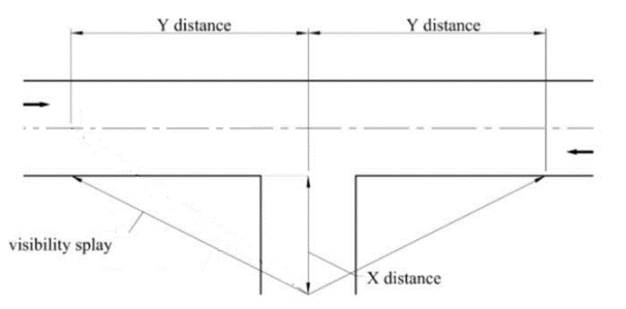
Figure 16.1 – Sightline Visibility Splay
Table 16.5 sets out the minimum visibility standards for new entrances. These are minimum standards and the Authority can request greater standards depending on the characteristic of the road, observed traffic speeds, volume and type of vehicles, etc. For significant and complex developments, suitably competent road designers should be used in the design layout. Within built up areas, sightlines may be reduced at the discretion of the planning authority. Note:- the visibility splay distance shall be measured at the driver’s eye height (taken as 1.05m) and the object height (taken as 0.6m).
|
Road Type |
Speed Limit (km/hr) |
Sight Distance Required “Y” (metres) |
Distance of Sight Line from Edge of Carriageway “X” (meters) |
|---|---|---|---|
|
National Road |
100 / 80 |
210 |
4.5 |
|
Regional Road |
100 |
210 |
4.5 |
|
80 / 60 |
150 |
2.5 |
|
|
Local Road |
80 / 60 |
90 |
2.5 |
Table 16.5 Sight Line Requirements and Distance from Edge of Carriageway
16.10.8 Distance of Entrances from Road Junctions
New rural entrances should not be located within the following distances of junctions:
- National Primary Roads 150 metres
- National Secondary Roads 100 metres
- Regional Roads 100 metres
- Local Primary Roads 40 metres
The development by itself or combined with another or other development shall not give rise to a traffic hazard.
16.10.9 National and Regional Roads
The National and Regional Road network should provide safe and efficient links between the principal towns and villages and thus contribute significantly to the economic prosperity of the County and state as a whole. Chapter 5: Sustainable Travel and Transportation provides specific policies and objectives with regard to development on National and Regional Routes. Development management shall seek to channel traffic from new development onto existing public local roads and in this way use established access points to gain entry onto national roads and shall have regard to the Policy Document, Spatial Planning and National Roads, Guidelines for Planning Authorities, (January 2012) published by the DoECLG.
16.10.10 Local Roads
In general, only the minimum interference with existing roadside boundaries and hedges shall be permitted in relation to visibility splays on Local Roads. Visibility splays to be stipulated at 90 metres unless a safety audit is submitted to justify a reduced sight distance. Any works required to obtain visibility, such as trimming hedging, removing hedging, trees, walls or fencing shall be shown clearly on a site layout plan or other suitable drawings with a planning application. Third party consent letters for works not on an applicant’s land is also required with the planning application. The applicant maybe requested to submit a formal legal agreement together with a map showing the extent of the lands affected outside the site boundary and detailing the works required to comply with the visibility splays. An undertaking maybe required from the landowner’s solicitor that the agreement will be entered as a burden against the title of the land.
If a development is located on a private laneway, details of maintenance and upgrade if required together with legal entitlement to carry out same shall be submitted with the planning application.
16.10.11 Car Parking
Developments shall be required to provide adequate provision within the site for the servicing of the proposal and for the parking and manoeuvring of vehicles associated with it (Refer Tables 16.6 and 16.7). Reduced car parking provision maybe considered for commercial town centre sites in accordance with Section 5.14. National Policy Objective 13 of the NPF advocates that planning standards should be flexibly applied in response to well-designed development proposals that can achieve urban infill and brownfield development objectives in settlements of all sizes. The development management standards regarding car parking provision may be relaxed in urban infill and brownfield sites subject to strict qualitative criteria and provided public safety is not compromised and the environment is suitably protected. In dealing with planning applications for change of use or for replacement buildings, allowance will be made for the former site use in calculating the car parking requirements generated by the new development. Where the provision of on-site parking is not possible, the Council may, in exceptional circumstances, accept a financial contribution in respect of the shortfall in the number of spaces.
Car parking provision shall comply with the following as appropriate;
- Planting and landscaping of all car parks shall be required;
- Parking facilities for mobility impaired drivers shall be appropriately sited and provided at a minimum rate of 5% where there is a requirement for 10 or more spaces;
- Age friendly parking shall be provided where possible;
- Lighting and car park signage as deemed appropriate by the Planning Author
- In all developments of an industrial or commercial nature, developers will be required to provide loading or unloading facilities sufficient to meet the demand of such development;
- Where a specific use is not listed in Table 16.7, the Council will specify its requirements in relation to parking; and
- Dimensions of parking and loadings spaces shall be as follows:
|
Parking space- perpendicular to kerb |
5.0m x 2.5m |
|
Parking Space- Parallel to wall or other obstruction |
5.0m x 2.75m |
|
Parking Space- Parallel to Kerb |
6.0m x 2.5m |
|
Accessible Parking Bays |
5.0m x 2.5m + 1.2m to the sides and rear |
|
Loading Bays |
6.0m x 3.0m |
|
Circulation Areas |
6.0m in width |
Table 16.6: Car Parking and Loading Dimensions
Table 16. Car and Bicycle Parking Standards
|
Land Use – Residential |
Car Spaces (max) |
Cycle Spaces (min) |
|---|---|---|
|
Dwelling House |
2 per unit |
1 per unit |
|
Apartment / Flat |
1.5 per unit |
1 per bedroom/ studio |
|
Hotels, B&B, Guesthouse, Hostel |
1 per bedroom |
1 per 20 beds |
|
Hostel |
1 per bedroom or 1 per 10 bed dormitories |
1 per 10 beds |
|
Student Accommodation |
To be determined by P/A |
1 per 3 beds |
|
Land Use – Commercial |
Car Spaces (max) |
Cycle Spaces (min) |
|
Food Retail |
1 per 20m2 GFA |
1 per 75m2 |
|
Non-Food Retail |
6 per 100m2 GFA |
1 per 100m2 |
|
Retail Warehousing |
1 per 35m2 of net retail floorspace |
1 per 500m2 |
|
Banks and Financial Institutions |
1 per 20m2 GFA |
1 per 50m2 |
|
Conference Centre |
1 per 25m2 |
1 per 20 seats |
|
Cash and Carry |
1 per 100m2 |
1 per 150m2 |
|
Warehousing |
1 per 100m2 |
1 per 500m2 |
|
Bars, Function Rooms, lounges |
1 per 10m2 |
1 per 75m2 |
|
Restaurants |
1 per 20m2 GFA |
1 per 75m2 |
|
Café |
1 per 10m2 dining area |
1 per 50m2 |
|
Takeaway |
1 per 18m2 GFA |
Nil |
|
Garages / Service Stations Retail Areas within Service Stations |
1 per fuel pump plus 1 per 10m2 of net retail floor area |
1 per 50m2 |
|
Car Showrooms |
1 per 50m2 GFA |
Nil |
|
Garden Centres / Factory Outlets |
2 per 100m2 GFA |
1 per 150m2 |
|
Cinema |
1 space per 10 seats |
1 per 20 seats |
|
Land Use – Employment |
Car Spaces (max) |
Cycle Spaces (min) |
|
Offices (Town Centre) |
1 per 25m2 of GFA |
1 per 5 employees |
|
Offices (Bus Park / other) |
1 per 20m2 of GFA |
1 per 10 employees |
|
Industry |
1 per 60m2 of GFA and operational car parking to be determined by the planning Authority |
1 per 500m2 |
|
Land Use – Health and Education |
Car Spaces (max) |
Cycle Spaces (min) |
|
Hospital |
1.5 per bed |
1 per 20 beds |
|
Clinics and Group Medical Practices |
3 spaces per consulting room plus staff |
1 per consulting room |
|
Nursing Homes |
1 per 2 bedrooms plus staff car spaces |
1 per 5 bedrooms |
|
Primary School |
1 per classroom plus staff and visitor parking |
1 per 5 students |
|
Secondary School |
2 per classroom plus staff and visitor parking |
1 per 4 students |
|
Third Level |
0.5 for every 1 student plus visitor and staff spaces |
1 per 3 students |
|
Creche / Childcare |
1 per staff member and 1 space per 4 children |
1 per 5 staff on duty |
|
Church Theatre/ Pubic Halls |
1 per 6 seats |
1 per 10 seats |
|
Land Use – Community Facilities |
Car Spaces (max) |
Cycle Spaces (min) |
|
Leisure Centre |
1 per 50 m2 GFA |
1 per 10m2 |
|
Gym |
1 per 10m2 |
1 per 10m2 |
|
Swimming Pool |
5 per 100m2 |
1 per 10m2 |
|
Community Centre |
1 per 10m2 |
1 per 10m2 |
|
Sports Grounds / Clubs |
20 per pitch / 2 per court |
5 per field/ 1 per court or lane |
|
Library/ Museum/ Gallery |
3 per 100m2 GFA |
1 per 50m2 |
|
Cinema |
1 per 10 seats |
1 per 20 seats |
|
Golf Course |
4 per hole |
Nil |
|
Pitch and Putt |
2 per hole |
Nil |
|
Golf Driving Ranges |
1 per bay / trap plus 3 spaces |
Nil |
|
Allotments |
1 per plot |
Nil |
16.10.12 EV Charging Points
All developments should provide facilities for the charging of battery-operated cars in accordance with the standards in S.I. No. 393/2021 EU (Energy Performance of Buildings) Regulations 2021 or as maybe updated by national legislation and guidance.
16.10.13 Cycling Parking
Cycle parking shall be provided at a minimum in accordance with Table 16.7. It shall be conveniently located, secure, easy to use, adequately lit and well sign posted.
16.11 Infrastructure and Environmental Management
16.11.1 Public Water Supply and Wastewater Collection
All new developments will be required to utilise and connect to the public water and wastewater network, where practicable. Applicants who require a new or modified connection to public water supply or wastewater collection infrastructure must liaise with Irish Water. Where the applicant has concerns about the feasibility of connecting to the public network, they should make a pre-connection enquiry to Irish Water in order to establish the feasibility of a connection in advance of seeking planning permission.
Development will only be permitted in instances where Irish Water confirm sufficient capacity is available or can be made available for appropriate collection, treatment and disposal of wastewater (in compliance with the Water Framework Directive and River Basin Management Plan).
16.11.2 Private Wells
Private bored wells used as a source of water supply to single dwellings are the responsibility of the householder. Such wells are not regulated under the European Communities (Drinking Water) Regulations, 2014. The Council and Irish Water have no regulatory function in this regard.
16.11.3 Domestic and Commercial Wastewater Treatment
For domestic dwellings site assessment and the design of waste water treatment systems and percolation areas shall conform with the Environmental Protection Agency’s ‘Code of Practice for Domestic Waste Water Treatment (2021).
Commercial Wastewater Treatment systems where deemed appropriate (Refer Section 6.4) must comply with the requirements of the Code of Practice Wastewater Treatment Manuals – Treatment Systems for Small Communities, Business, Leisure Centres and Hotels (EPA, 1999).
A detailed site investigation report, to include percolation and water table tests certified by a qualified person, should be provided with the Planning Application.
16.11.4 Sustainable Urban Drainage Systems
All new developments (including amendments / extensions to existing developments) will be required to incorporate ‘Sustainable Urban Drainage Systems’ (SuDS) as part of the development/design proposals. SuDS seeks to manage the water as close as possible to its origin replicating the natural characteristics of rainfall runoff from any site, ensuring water is infiltrated or conveyed more slowly to the drainage system and ultimately to water courses via permeable paving, swales, green roofs, rain water harvesting, detention basins, ponds and wetlands (Refer; Chapter 6, Section 6.5).
16.11.5 Construction and Environmental Management Plans
Construction Environment Management Plans shall be a requirement of any major planning permission for residential, community, employment or infrastructure related development and implemented throughout the construction / operational period as appropriate. The Plan shall be prepared having regard to the EPA Best Practice Guidelines for the preparation of Resource Management Plans for Construction and Demolition Waste Projects. Such plans shall incorporate relevant mitigation measures which have been integrated into the plan / project and where relevant any Environmental Impact Assessment or Appropriate Assessment.
CEMPs typically provide details of intended construction practice for the proposed development, including:
a) location of the sites and materials compound(s) including area(s) identified for the storage of construction refuse;
b) location of areas for construction site offices and staff facilities;
c) details of site security fencing and hoardings;
d) details of on-site car parking facilities for site workers during the course of construction;
e) details of the timing and routing of construction traffic to and from the construction site and associated directional signage;
f) measures to obviate queuing of construction traffic on the adjoining road network;
g) measures to prevent the spillage or deposit of clay, rubble or other debris;
h) alternative arrangements to be put in place for pedestrians and vehicles in the case of the closure of any public right of way during the course of site development works;
i) details of appropriate mitigation measures for noise, dust and vibration, and monitoring of such levels;
j) containment of all construction-related fuel and oil within specially constructed bunds to ensure that fuel spillages are fully contained (such bunds shall be roofed to exclude rainwater);
k) disposal of construction/demolition waste and details of how it is proposed to manage excavated soil, including compliance with the EPA’s ‘Best Practice Guidelines for the Preparation of Resource Management Plans for Construction & Demolition Projects 2021, which supersedes previous 2006 Guidelines published by the Department of the Environment, Heritage and Local Government;
l) a water and sediment management plan, providing for means to ensure that surface water runoff is controlled such that no silt or other pollutants enter local water courses or drains;
m) details of a water quality monitoring and sampling plan;
n) if peat is encountered - a peat storage, handling and reinstatement management plan;
o) measures adopted during construction to prevent the spread of invasive species (such as Japanese Knotweed);
p) appointment of an ecological clerk of works at site investigation, preparation and construction phases; and
q) details of appropriate mitigation measures for lighting specifically designed to minimise impacts to biodiversity, including bats.
16.11.6 Soil Protection, Contamination and Remediation
Where appropriate adequate soil protection measures shall be outlined in planning applications submitted. Adequate and appropriate investigations shall be carried out into the nature and extent of any soil and groundwater contamination and the risks associated with site development work, where brownfield development is proposed.
The EPA’s publication Code of Practice: Environmental Risk Assessment for Unregulated Waste Disposal Sites (2007) shall be taken into account as relevant by proposals for development within or adjacent to old landfill sites.
All undeveloped, contaminated sites shall be remediated to internationally accepted standards prior to redevelopment. All applications shall be accompanied by a report from a qualified, expert consultant on remediation incorporating international best practice and expertise on innovative ecological restoration techniques including specialist planting and green initiatives that create aesthetically improved sites, healthy environments and contribute to the provision of new green open spaces as integral parts of newly created areas.
Treatment/management of any contaminated material shall comply as appropriate with the Waste Management Act 1996 (waste licence, waste facility permit), as amended, and under the EPA Act 1992 (Industrial Emissions licensing, in particular the First Schedule, Class 11 Waste), as amended. These measures will ensure that contaminated material will be managed in a manner that removes any risk to human health and ensures that the end use will be compatible with any risk.
Prior to the grant of approval on contaminated sites, developers will be required to carry out a full contaminated land risk assessment to demonstrate:
- How the proposed land uses will be compatible with the protection of health and safety (including the durability of structures and services) - during both construction and occupation; and
- How any contaminated soil or water encountered will be appropriately dealt with.
16.11.7 Peatlands
Developments sited on peatlands have the potential to increase overall carbon losses, potentially undermining expected carbon savings (in the case of renewable energy developments) and damaging rare habitats of European importance. When developing project proposals for developments on peatlands the following assessments maybe required:
- Peatland stability;
- Carbon emissions balance; and
- Hydrology and Ecology.
Where relevant the Council will support the implementation of recommendations contained in the National Peatlands Strategy 2015.
16.11.8 Waste Management Infrastructure
In assessing development proposals for, or including waste recovery / disposal facilities, the Planning Authority will have regard to the provisions of the Southern Region Waste Management Plan 2015-2021 (or as maybe amended), relevant planning legislation, the objectives in this Plan and other relevant planning documents.
16.11.8.1 Waste Recovery / Disposal
Planning applications for waste related facilities will be assessed having regard to:
- The sensitivity of the site: Facilities impacting upon Special Areas of Conservation (SACs), Special Protection Areas (SPAs), Natural Heritage Areas (NHAs), areas protected for landscape character, visual amenity, geology, heritage or cultural value, or areas at risk of flooding.
- Traffic and Transport: A Traffic and Transportation Assessment will be required to be submitted in most cases. All proposals shall indicate details of road access, sightlines / visibility, vehicle turning manoeuvres, parking areas, pull-in areas, the number and types of vehicles which will frequent the site, the carrying loads of vehicles, and haul routes.
- Surface Water Drainage: A sustainable drainage system will be applied to proposed developments, and proposals shall have regard to the requirements of the EU Water Framework Directive and associated River Basin Management Plans.
- Emissions: Details of potential noise, odours, dust, grit, vibration and lighting, along with controls and monitoring of same, will be required.
- Landscaping and Restoration Proposals: Boundary treatments, screening proposals and remediation measures, including a timeframe for implementation, shall be required.
- Impact on Residential Amenity: The Council will consider the proximity to residences and the impact on same (including through the considerations of traffic, emissions etc. outlined above).
- Requirement for Environmental Impact Assessment: Proposals shall be screened for the requirements of mandatory and sub-threshold Environmental Impact Assessment. An EIAR shall be submitted as required.
- Appropriate Assessment Screening / NIS as maybe required.
16.11.8.2 Bring Banks and Recycling Facilities
Bring bank facilities will generally be required in conjunction with significant new commercial developments or extensions to same and in conjunction with large scale residential and mixed -use developments. The location and design of the recycling facility shall consider accessibility for resident / public and truck access arrangements, together with measures to mitigate any adverse impacts on existing or future residential amenities e.g. noise mitigation, screening/ landscaping, lighting etc.
16.11.9 Development and Overhead Power Lines
Development proposals within the distances specified below should contact the ESB in advance prior to pre-planning stage, so as to ensure that the relevant clearances are maintained from any High Voltage Overhead Electricity (HV OHL) Infrastructure.
- For buildings in proximity to a 110kv overhead line, 20 metres either side of the centreline or 23 metres either side of the centre line of a pylon.
- For buildings in proximity to a 220kv overhead line, 30 metres either side of the centre line or around a pylon.
For buildings in proximity to a 10kv or a 38kv overhead line, no specific distance is specified. However, a site-specific clearance may be required.
16.11.10 Undergrounding Cables
Where undergrounding of cables is being pursued, proposals should demonstrate that environmental impacts including the following are minimised:
- Habitat loss as a result of removal of field boundaries and hedgerows (right of way preparation) followed by topsoil stripping (to ensure machinery does not destroy soil structure and drainage properties);
- Short to medium term impacts on the landscape where, for example, hedgerows are encountered;
- Impacts on underground archaeology;
- Impacts on soil structure and drainage; and
- Impacts on surface waters as a result of sedimentation.
16.11.11 Telecommunications and Supporting Infrastructure
Proposals for telecommunications antennae and support structures will be assessed in accordance with the Telecommunications Antennae and Support Structures – Guidelines for Planning Authorities, DELG, (1996), as revised by Circular Letter PL 07 / 12, and any other publications and material as may be relevant in the circumstances.
Planning applications for new facilities should include:
- A reasoned justification regarding the need for the particular development at the proposed location. This shall detail the significance of the proposed development to the telecommunications network, including a map of the area and existing coverage in the area.
A technical explanation shall be provided of the reasons why coverage cannot be provided by existing antennae.
- Details of efforts (i.e written correspondence) made to share installations or co-locate / cluster with existing structures; this should reference a map showing the location of all existing structures within a minimum 2km radius of the proposed site.
- Evidence of consideration of alternative sites and explanation of their unsuitability.
- Visual impact assessment and mitigation measures (e.g. landscape screening, colour treatment of masts / antennae).
- Any impacts on rights of way and walking.
16.11.12 Major Accidents Directive / Seveso Sites
In the event that any Seveso Sites are proposed / identified within County Carlow during the period of this Plan, the Council will have regard to the technical advice of the Health and Safety Authority in relation to proposed development and proposed land uses.
Developers of Seveso sites and any sites adjacent to such sites are encouraged to consult with the Fire Services of Carlow County Council and the Health and Safety Authority prior to the submission of any planning application16.12 Climate Action and Energy
16.12 Climate Action and Energy
16.12.1 Built Environment - Climate Action
The Council will encourage all new development proposals to incorporate sustainable building practices, sustainable products and incorporate design and layout criteria which minimise energy use, including by passive solar design, energy efficient building design and emission reduction measures.
An Energy Statement should be submitted for all applications of 1000+sqm commercial / business development or applications of 30+ residential units to demonstrate what energy efficiency and carbon reduction design measures are being considered.
Applicants should explore the potential for urban greening in developments including:
- High quality landscaping (including tree planting), that make use of a diverse range of species of plants – consistent with the National Pollinator Plan, site appropriate and irrigated by rainwater.
- Incorporating Nature-Based Solutions (NBS) into the design of buildings and layout – living/green walls, living/green and or blue roofs including in the design of small buildings and shelters, other soft Sustainable Urban Drainage Systems (SUDS) measures such as swales, rain gardens, using trees for urban cooling and the reduction of wind tunnel effect.
16.12.2 Energy Development Projects
Proposals for energy development will be considered in the context of current Government policy on the subject but will take into account other, often competing Council policies on land usage relating to sectors such as agriculture, tourism and outdoor recreational activities, the protection of sensitive landscapes, sensitive ecological sites, and any relevant guidelines issued from time to time by the Department of Housing, Local Government and Heritage.
Proposals should demonstrate that human health has been considered, including those relating to the topics of:
- Noise (including consistency with the World Health Organisation’s 2018 Environmental Noise Guidelines for the European Region);
- Shadow Flicker (for wind turbine developments, including detailed Shadow Flicker Study);
- Ground Conditions/Geology (including landslide and slope stability risk assessment);
- Air Quality; and Water Quality.
Environmental assessments should address reasonable alternatives for the location of new energy developments, and where existing infrastructural assets such as sub-stations, powerlines and roads already exist within proposed development areas, then such assets should be considered for sustainable use by the proposed development where the assets have capacity to absorb the new development.
16.12.3 Wind Energy
The Council acknowledges the role of wind energy as a renewable energy resource. Chapter 10 Climate Action and Energy and Appendix VI Renewable Energy Strategy detail policies and objectives for this sector over the period of this Plan. When assessing planning applications for wind energy developments the Council will have regard to the Wind Energy Development Guidelines for Planning Authorities, DoEHLG, (2006) and any amendments to the Guidelines which may be made and the Interim Guidelines for Planning Authorities on Statutory Plans, Renewable Energy and Climate Change (2017). Applications shall be accompanied by all relevant environmental assessments including impact on collision risk species (birds and bats). Applications will also be required to ensure that development is in accordance with the guidance provided in Chapter 9 Landscape and Green Infrastructure and Appendix VII Landscape Character Areas with regard to compatibility between the land use and the principal Landscape Character Areas of the County and the proximity to Landscape Sensitivity Factors.
16.12.4 Solar Energy
Chapter 10 Climate Action and Energy and Appendix VI Renewable Energy Strategy recognise the potential availability of potential solar resources in the County. The Council will consider solar renewable energy development having regard to the following criteria:
- Any future Section 28 Ministerial Guidance.
- Site suitability.
- Any environmental sensitivities in the landscape.
- Landscape Character Areas of the County.
- Visual impact, zones of influence including cumulative visual impact/zones of influence of existing / permitted solar farms and associated infrastructure such as road access.
- Glint and Glare impacts on roads, dwellings, national monuments, protected structures and other sensitive receptors.
- The need to protect residential amenities of adjoining properties
- Archaeological Impact Assessment and Heritage Impact Assessment.
- Ecological Impact Assessment.
- Landscaping plans to appropriately integrate the development into the landscape.
- Security requirements such as CCTV, security lights, fencing etc.
- Impacts from lighting.
- Construction impacts.
- Impacts on drainage patterns and water tables.
- Suitability of and access to the electricity grid.
- Decommissioning Statement
16.13 Community Development
16.13.1 Childcare Facilities
The Planning Authority will seek to facilitate the provision of childcare facilities in appropriate locations throughout the County in accordance with the provisions of the DEHLG ‘Childcare Facilities Guidelines for Planning Authorities’ (2001) and Circular Letter PL3 – 2016 or any superseding guideline, together with the Child Care (Pre-School Services) (No.2) Regulations (2006) and Child Care (Pre-School Services) (No. 2) (Amendments), Regulations (2006) (Dept. of Health and Children.
In addition to the foregoing in the assessment of individual planning applications for childcare facilities, the Planning Authority will have regard to the following criteria:
- Suitability of the site / development for the type and size of facility proposed.
- Accessibility to the facility including pedestrian, cycle and public transport provision.
- Provision of adequate set-down and pick up areas.
- On site car parking for staff and visitors.
- Local traffic conditions.
- Impacts on the amenities of adjoining residential properties where proposed in existing established residential areas. The complete conversion of existing semi-detached and terraced dwellings within housing estates is generally discouraged. The childcare use should remain secondary to the primary residential use of the premises.
- Purpose built facilities in new residential areas are most appropriately located at or near the front of the estate.
Applicants are recommended to seek the advice of the Carlow County Childcare Committee, and the HSE in the design of childcare facilities prior to the submission of a planning application.
16.13.2 Educational Facilities
The Planning Authority will consider school developments having regard to specific requirements of the Department of Education and guidance set out in ‘The Provision of Schools and the Planning System. A Code of Practice for Planning Authorities’ (2008) or any amendment thereof together with the requirements of Technical guidance document TGD 025 (or any such updated document) in respect of primary schools and Technical guidance document TGD 027 (or any such updated document) in respect of post primary schools.
In assessing individual planning applications for new schools and/or redevelopment /extensions of existing schools, the Council will have regard to the following:
- Site location, proximity of school to catchment area, size of site relative to outdoor space requirements and the future needs of the school (i.e. sufficient space provided for future expansion);
- Traffic and transport impact on the surrounding road network;
- Good, safe accessible pedestrian and cyclist routes to and from the school from nearby residential and commercial areas;
- Safe access and adequate car parking layout to facilitate drop off/pick up;
- Adequate signage, lighting and boundary treatments; and
- Impact on local amenities and out of school hour’s uses/dual functioning of school facilities.
Extensions to schools will generally be accepted subject to scale, high quality design and satisfactory integration with the existing structure. Dual function of sports facilities and halls will be encouraged where the use is of benefit to the wider community and has due regard to the residential amenities of adjoining properties. Temporary school structures will generally be accepted on a temporary basis subject to the development not impacting unduly on on-site car parking/ cycle parking provision.
16.13.3 Residential Care Facilities
The Planning Authority promotes the location of residential care facilities within appropriately zoned lands or within the development boundary of existing settlements. The provision of such facilities should comprise a high-quality design and finish and be appropriately sited with sufficient capacity in the local road network and adequate car parking provision. Only in circumstances as outlined in Policy OP 1 will residential care homes and nursing homes be facilitated in the rural countryside.
In considering applications for these developments, the Planning Authority will have regard to the following:
- The existing social facilities and demand within the area. In locations where there is a grouping of a particular user group, applications should include an assessment of the impact on local services.
- The impact on the physical character of the area such as car parking levels and private amenity space.
- The impact on noise and disturbance from additional traffic in the area.
- A high level of residential amenity (including well designed open space) shall be provided for residents of nursing homes.
- Whether the size and scale is appropriate to the area.
- Creation of an alternative living environment with views from all bedrooms to landscaped/ planted areas.
- Impact on amenities of adjoining properties.
16.13.4 Medical Centres/ Health Centres / Veterinary Surgeries
Medical centres / surgeries, local health centres and veterinary surgeries which meet the needs of and are easily accessible to local service users will be favourably considered on appropriately zoned land, including district and neighbourhood centres subject to proper planning and environmental considerations.
In assessing proposals for part conversion of detached residential units in established residential areas, Carlow County Council will consider conversion of part of a dwelling to a medical, veterinary or related consultancy provided the dwelling remains as the main residence of the operating practitioner and where a local need has been demonstrated, the amenity of adjoining residential properties is protected and adequate off- street parking facilities are provided.
16.13.5 Places of Worship
Development proposals for the use of a building as a place of public worship or religious instruction will be considered in the context of the land use zoning, the compatibility of the use with surrounding established uses, the potential capacity of the building, the traffic and parking requirements, and the potential impact on residential amenity of adjoining properties.
Planning applications for places of worship should be accompanied by details of:
- The capacity of the facility (e.g. seating capacity);
- A traffic assessment (including details of the proposed parking provision); and
- Intended hours of operation.
Extensions to existing places of worship will be considered where they do not create unacceptable traffic congestion or car parking difficulties or cause a nuisance to existing residents or businesses.
16.14 Natural and Built Heritage
16.14.1 Natural Heritage
The overall policies and objectives relating to natural heritage are set out in Chapter 10 of this Plan and all planning applications will be assessed having regard to same. Development proposals should consider potential ecological impacts on the natural heritage and green infrastructure present within or adjacent to the site and the following:
- Special Areas of Conservation and Special Protection Areas (including candidate areas);
- Salmonid Waters and Freshwater Pearl Mussel catchments;
- Green infrastructure including features of the landscape that provide linkages / connectivity to designated sites (e.g. watercourses, areas of seminatural habitat such as linear woodlands, etc.);
- Proposed Natural Heritage Areas; and
- Areas likely to contain a habitat listed in Annex I of the Habitats Directive.
Refer to Section 16.2.1 regarding Appropriate Assessment requirements.
A plan may only proceed if it can be concluded on the basis of Appropriate Assessment that there will be no adverse effects on the integrity of a Natura 2000 site. If adverse effects are likely, or in cases of doubt, then derogation under article 6 (4) shall apply, but only in cases of imperative reasons of overriding public interest.
16.14.2 Protected Habitats, Plants, Animals and Birds
There are a number of habitats, plant, animal and bird species within County Carlow which are protected under National and EU legislation. In the event of a proposed development impacting on a site known, or likely, to be a breeding or resting site of a species listed in the Habitats Regulations a derogation license, as per Article 16 of the Habitats Directive issued by the NPWS, will be required in advance of permission. The Wildlife Act 1976 is the principal national legislation providing for the protection of wildlife and the control of some activities that may adversely affect wildlife. Licenses are issued by the NPWS for species listed in the Act.
A precautionary approach should be taken to all proposals in environmentally sensitive areas and/or to sites that may be in use by, or contain, protected species. In order to comply with European and National legalisation on nature conservation, and to ensure that areas of biodiversity value are adequately protected, an ecological impact assessment will be carried out for development proposals which have potential to impact on species and habitats protected. (See also Section 16.2.4).
In the event of lighting being proposed along river corridors an Ecological Impact Assessment (and where necessary an Appropriate Assessment) - including bat and otter surveys - shall be conducted by specialist consultants. The recommendations of the specialist studies shall be implemented. No lighting will be installed without prior consultation with the NPWS and shall be in line with:
- Advances in knowledge into the impact of lighting on bats and other species and
- Reflect advances in technology in the lighting industry.
16.14.3 Archaeology
Any development in the vicinity of a site included in the Record of Monuments and Places (RMP) or within a Zone of Notification will require archaeological investigations to be carried out in accordance with the ‘Framework and Principles for the Protection of the Archaeological Heritage’ published by the Department of Arts, Heritage, Gaeltacht, and the Islands in 1999.
- Applications for development that may have potential impact on archaeology shall be accompanied by an Archaeological Impact Assessment and Method Statement, prepared by a licensed archaeologist. To ensure the long-term preservation of recorded monuments and their setting, a Conservation Plan may be required, depending on the nature of the development and the relationship of the development with the monument(s).
- All planning applications and other development proposals which are in, or might affect, sites and features of historical and archaeological interest, shall be referred to the Minister through the Department of Housing Local Government and Heritage. In considering such planning applications, the Planning Authority will have regard to the views and recommendations of the National Monuments Service, Department of Housing Local Government and Heritage and other interested bodies.
Carlow County Museum should be informed of archaeological objects found as part of authorised excavations, so they and the National Museum of Ireland can give consideration to the long-term repository for these archaeological finds.
16.14.4 Architectural Heritage
Appendix VIII contains the list of the Record of Protected Structures (RPS) within County Carlow. The designation includes the exterior and interior of the structure, the land lying within its curtilage (boundary), any other structures and their exterior and interiors lying within that curtilage, plus all fixtures and features which form part of the interior and exterior of any of these structures.
Any works which materially affect the character of a Protected Structure requires planning permission. Owners or occupiers proposing to carry out any works to a Protected Structure can seek a declaration (Section 57) from the Planning Authority as to the type of works that would or would not materially affect the character of the Protected Structure or any element of the structure which contributes to its special interest.
All planning applications for works to a Protected Structure must include an Architectural Heritage Impact Assessment in accordance with Appendix B of the DAHG ‘Architectural Heritage Protection Guidelines for Planning Authorities’, to assist in the assessment of proposals. This report should be prepared by an appropriately accredited conservation architect. The report should:
- Outline the significance of the building(s).
- Include a detailed survey of the building identifying all surviving original/early features and associated photographic survey.
- Include a method statement and specification of works.
- Details of proposed works should be clearly identified on the accompanying survey drawings by way of colour coding and/or annotated notes to distinguish clearly between the existing structure and the proposed work.
The detail required to be submitted will be dependent on the significance of the building and the nature and extent of works proposed. All works to protected structures shall be carried out in accordance with best conservation practice.
16.14.5 Change of Use – Protected Structures
A change of use of a Protected Structure can, in some cases assist in supporting the long-term conservation of the structure. In such cases regard should be had to the compatibility of such use, in terms of its impact on the character and special interest of the structure. Whilst a degree of flexibility in design standards may be considered, any extensions, new openings, or modifications shall be carefully considered to ensure the works do not detract from the historic fabric or value of the structure.
16.14.6 Development within the Curtilage of a Protected Structures
Proposed development which might have an adverse impact on the setting of a protected structure, including its curtilage and attendant grounds, will not be encouraged.
Proposed development within view of protected structures, including their curtilage, demesne lands and attendant grounds shall have regard to the following:
- Development shall not be permitted where it adversely affects or would adversely interfere with the setting of protected structures;
- Where relevant, outward and inward views from the protected structure and key points within the curtilage, demesne lands and attendant grounds are to be protected;
- Development proposals must demonstrate that they are part of an overall strategy for the conservation of the entire built heritage complex and contribute positively to that aim; and
- The likely impact of any proposed development on the protected structure and its setting, including its curtilage and attendant grounds, in terms of design, scale, massing, height, plot, width, roof treatment, materials, landscaping, mix and intensity of use proposed should be addressed in any planning proposal. The design of the proposed development should relate to and complement the special character of the protected structure. High quality design will be a foremost consideration when assessing proposals for development within the curtilage of a protected structure.
16.14.7 Architectural Conservation Areas
The guiding principle of ACAs is to protect the special external expression of the buildings and the unique qualities of the area to ensure future development is carried out in a manner sympathetic to its distinctive character. Owners, occupiers or developers proposing to carry out works within an ACA should be aware that the normal exemptions from seeking planning permission will no longer apply if the Planning Authority considers the works will materially affect the character of the ACA.
In Architectural Conservation Areas the Council will have regard to the following:
- The effect of the proposed development on buildings and the surrounding environment, both natural and man-made.
- The impact of development on the immediate streetscape in terms of design, scale, height, plot, width, roof treatment, materials, landscaping, mix and intensity of use proposed.
- New alterations and extensions should complement existing buildings / structures in terms of design, external finishes, colour, texture, windows / doors / roof / chimney / design and other details.
- In dealing with advertisements in Architectural Conservation Areas, the overriding consideration will be the enhancement and protection of the essential visual qualities of the area.
16.15 Tourism and Recreation
16.15.1 Tourism Development
Any proposal for a tourism related activity or development shall include a supporting business and design statement outlining the following:
- Justification for proposal by reference to anticipated demand of the public for the local environmental attractions;
- An overview of the proposal setting out how the concept for the project was initiated and why it is suited for the location chosen;
- How the design and scale which should be simple in form and function will integrate into the landscape so as not to interfere with the visual setting of sensitive visual attractions;
- How the proposal would complement the natural and cultural heritage of the area while respecting local biodiversity;
- The potential impacts of the proposal on local infrastructure in particular roads and water services;
- Anticipated modes of transport to the facility;
- Promotion of accessible tourism and provision of inclusive access;
- Provision of inclusive access
- Any signage / interpretative panels required; and
- How the development would complement established tourism complexes and facilities in the County.
In terms of sustainable forms of niche tourism and recreation, facilities should be located within existing structures, or in buildings of character requiring renovation or in traditional vernacular buildings where possible. Where new buildings are proposed, they should be modest in scale, sensitively located and designed having regard to existing buildings, topography and landscape.
16.15.2 Bed and Breakfast, Guest House, Hotel, Hostel
In determining planning applications for both new and a change of use to bed and breakfast, guest house, hotel or hostel in residential areas, the Planning Authority will have regard to the following:
- Size and nature of facility;
- Compatibility with adjoining land uses;
- The standard of accommodation for the intended occupiers of the premises;
- The availability of adequate, safe and convenient arrangements for car parking and servicing;
- The type of advertising proposed
- The effect on protected structures and / or conservation areas; and
- The number of existing such facilities in the area.
16.15.3 Caravan, Camping and Glamping Sites
Caravan, camping / glamping sites shall generally be located within the development boundary of established towns, village and settlements. Consideration however will be given to small scale facilities in appropriate locations outside of towns, villages and settlements subject to a demand and need for the facility being demonstrated to the satisfaction of the Planning Authority. This will require the preparation of a Business and Design Statement outlining, why the chosen location is the most appropriate for the facility. The development shall be appropriate in scale, layout and design to the existing character of the area. Planning applications shall demonstrate compliance with all other planning and environmental criteria including suitability of the location, design, scale, integration into the landscape, acceptable access and service arrangements, protection of residential amenities, in addition to maintaining natural heritage and the local environment.
16.15.4 Tourism Activities / Developments Based on Natural Features
There are a range of recreational activities based on natural resources. In many cases these are generally based in rural areas.
- All planning applications for these adventure / recreational activities involving special natural features should be accompanied by a management plan indicating projected numbers of users, hours of operation, seasons of operation, and an undertaking to protect the natural environment in the form of a risk assessment with proposed amelioration measures in respect of flora, fauna, hydrology, geology and soils.
- Proposals should seek to manage any increase in visitor numbers in order to avoid significant effects including loss of habitat and disturbance, including ensuring that any new projects are a suitable distance from ecological sensitivities. Where relevant, the Council and those receiving permission for development under the Plan shall seek to manage any increase in visitor numbers and/or any change in visitor behaviour in order to avoid significant effects, including loss of habitat and disturbance. Management measures may include ensuring that new projects and activities are a suitable distance from ecological sensitivities. Visitor/Habitat Management Plans will be required for proposed projects as relevant and appropriate.
- All proposals should be accessible insofar as possible by sustainable means of transport including public transport and by modes other than the car.
- Where the traffic generated is likely to exceed the capacity of the local road network or require changes to the road network that would adversely affect the character of the area, these will not be permitted.
- Where the activity is likely to be noise generating, a noise assessment will be required in connection with the application, measuring likely noise levels at the nearest noise sensitive recipients. Measures to mitigate any adverse impacts shall be identified.
16.15.5 Sports and Recreational Facilities
Planning applications for community facilities such as sports grounds, golf courses, playing fields and community halls / centres will be considered based on:
- The need for the development and its role in the development of local facilities.
- The appropriateness of the site in terms of location, traffic, accessibility and the impact on amenities of properties in the vicinity.
- The potential for multi-use by other groups/members of the community.
16.15.6 External Floodlighting-Sport Facilities
The provision of external floodlighting will be carefully considered by the Council in order to protect residential amenity, nature and traffic safety. Floodlights shall have fully-shielded light fixtures with cowl accessories to ensure that upward light levels are low. Planning applications shall include:
- Details of horizontal and vertical luminance levels (lux levels) of the lights; (note - reference should be made to BS EN 12193:2007 Light and Lighting – Sports Lighting); and
- Proposed hours of use.
16.16 Rural Development
16.16.1 Agricultural Buildings and Structures
The design, scale, siting and layout of agricultural buildings should respect, and where possible enhance the rural environment. In the construction and layout of agricultural buildings, the Council will require;
- That buildings are sited appropriately in order to minimise obtrusion on the landscape. The Council will generally seek to cluster agricultural buildings and structures together to assimilate effectively into the landscape and will encourage the reuse of any redundant farm buildings where viable.
- Use of dark coloured cladding (dark browns, greys, greens and reds)
- Satisfactory treatment of effluents, including yard run-off within the confines of the site;
- Compliance with the European Union (Good Agricultural Practice for Protection of Waters) (Amendment) Regulations 2014.
- Traffic safety considerations.
In the case of new farm enterprises, a clear evidence base must be provided which demonstrates the need for the proposal and details of how any buildings proposed form part of a comprehensive business plan for the farm holding supported by Teagasc.
16.16.2 Intensive Agriculture/ Pig and Poultry Farming
In addition to the requirements of Section 14.4 intensive agricultural developments shall be accompanied by the following:
a) An Environmental Impact Assessment (EIA) and/or Appropriate Assessment depending on the size and use of the unit, and its likely impact on the environment.
b) Details of the scale and intensity of the proposed development and existing operations in the vicinity of the site, including the cumulative impact of similar type developments within proximity of the site.
c) Methods for waste management including frequency and location of disposal relative to the proposed unit.
d) Details which will confirm compliance with the European Union (Good Agricultural Practice for Protection of Waters) Regulations 2017, as amended.
e) Details of air pollution arising from the units and effluent storage, transportation and spreading.
f) Proximity of development to aquifers and water courses and its impact on them.
g) The potential impact of the proposal on the residential amenity of adjoining occupiers must be considered.
h) Details of associated activities such as cleaning, ventilation and heating.
i) A comprehensive landscaping plan.
j) A statement outlining why a location on the landholding was deemed more appropriate to alternative options. If the Planning Authority, consider a more appropriate location is available on the landholding the application may not receive favourable consideration.
k) Traffic management plans and traffic assessment associated with the proposed development may be required for large proposals.
16.16.3 Extractive Industries
The development, continuation of use or diversification of activities relating to the extractive industry will be assessed having regard to the Quarrying and Ancillary Activities (DEHLG 2004) (or any superseding national policy document, Guidelines for Environmental Management in the Extractive Industry (EPA, 2006), Guidance on Biodiversity in the Extractive Industry (NPWS), GSI’s Geological Heritage Guidelines for the Extractive Industry (2008), the Archaeological Code of Practice (2009) and the Irish Concrete Federation Environmental Code (2005) and any other relevant superseding policy guidance.
Applicants should submit the following information at application stage:
- Map showing total site area, area to be excavated, and any ancillary proposed development, nearest dwellings or any other development (within 1 km of the site), including any established rights of way through the site;
- Description of the aggregate(s) to be extracted, method of extraction, any ancillary processes (such as crushing, concrete manufacture, etc.), equipment to be used, stockpiles, storage of soil and overburden, storage of waste materials, settling ponds;
- Total and annual tonnage of extracted aggregates, expected life of the extraction, maximum extent and depth of working, phasing programme;
- Description of development works (buildings, fixed and mobile plant, roads, fuel tanks, water supply and drainage, earth mounds, etc.);
- Description of water courses and water table depth, natural and cultural heritage, traffic impact and waste management;
- Description of cumulative impact when taken together with other quarries in the vicinity;
- Likely environmental effects including EIA where relevant;
- Proposed mitigation measures;
- Phased restoration and after-care proposals; and
- Proposals for surface water management and flood risk minimisation.
The Council may require the submission of an EIAR for sub-threshold development where it is considered that the development would be likely to have significant effects on the environment.
The restoration of disused pits and quarries to productive agricultural use will be encouraged where appropriate having regard to all appropriate environmental considerations. Other possible post closure uses may be considered such as recreational facilities and natural habitat areas.
A condition requiring the lodgement of a financial bond will be included in any grant of permission to ensure the satisfactory reinstatement of the site following the completion of extraction.
A Special Contribution in accordance with Section 48 of the Planning and Development Act, 2000 (as amended), may be imposed for the upgrade or maintenance of the local road network to facilitate the proposed development.
16.16.4 Land Reclamation
The Council recognises in certain circumstances the need for land reclamation for the improvement of agricultural purposes. Any proposal for land reclamation developments will be required to include the following information:
- A rationale and justification for the improvement of agricultural land;
- Quantities of materials in tonnes having regard to Mandatory EIA Thresholds;
- The relationship of the site with any European Sites and sites of ecological importance. The development shall not create any adverse effect on the integrity of the conservation objectives of any European Sites or protected species;
- Potential impact on species protected under EU or national legislation, outside of protected sites;
- Details of potential impacts on groundwater and surface waters;
- Visual impact – cross-sections of existing and proposed ground levels. The development shall not interfere with the character of the surrounding landscape;
- Details of the type and quantity of material to be imported. Only clean, inert material will be allowed;
- A traffic management plan including haulage routes and daily/weekly truck movements;
- Details of how noise, dust and emissions will be managed;
- Residential amenity – an assessment shall be carried out on the potential impact of the development on any residential properties in the vicinity of the lands; and
- A phasing programme for the duration of the works.
Any development will be required to have the requisite waste authorisation in place in accordance with the stipulations of the Waste Management Act 1996 or any subsequent updated guidance or legislation.
16.17 Development Contributions
16.17.1 Development Contributions
Section 48 of the Planning and Development Act 2000 (as amended) allows the Planning Authority when granting planning permission to include conditions requiring the payment of a financial contribution in respect of public infrastructure and facilities benefitting development in the area of the planning authority and that is provided, or that it is intended will be provided, by or on behalf of a local authority. The current Carlow County Development Contributions Scheme 2017 – 2021 sets out the contributions applicable to development, the scheme or an updated scheme adopted should be consulted in advance of the making of a planning application. There are three types of development contributions; General, Special and Supplementary.
16.17.2 General Development Contributions
These contributions apply in respect of public infrastructure and facilities provided by or on behalf of the Planning Authority that benefit development in its functional area, as noted above. Section 48 (1) of the Act outlines that a Planning Authority when making a grant of permission, may include a condition requiring the payment of a contribution in respect of public infrastructure and facilities such as open spaces, community and recreational facilities and amenities and landscaping works; infrastructure to facilitate public transport, cycle and pedestrian facilities; refurbishment, upgrading, enlargement or replacement of roads and surface water drainage infrastructure.
16.17.3 Special Development Contributions
In circumstances where additional specific infrastructure for an area is required, the Council may attach a special contribution.
Developers may also be required to carry out works at their own expense to facilitate their development and this would be specified as a condition of the planning permission.
16.17.4 Supplementary Development Contributions
Under Section 49 of the Act, a Planning Authority may, when granting permission include conditions requiring the payment of a contribution in respect of any public infrastructure service or project specified in a “Supplementary Development Contribution Scheme” that will benefit the development to which the planning permission relates. Supplementary Development Contribution Schemes maybe adopted over the period of the Plan.
16.18 Land Use Zoning
16.18.1 Introduction
This section sets out the general land use and zoning objectives for the town and village plans contained in Chapter 15 of this Plan. Guidance on each of the land use zoning categories is provided, as well as the objectives that apply to them.
The primary purpose of land use zoning is to promote the orderly development of settlements within the County. It is based on a zoning strategy that seeks to:
- Ensure that sufficient lands are zoned to allow the aims of the core strategy to be realised.
- Promote particular classes of use in appropriate locations and to assist and provide certainty to the public and communities in accessing the most appropriate locations for new development.
- Only consider lands for zoning if there is a likelihood that these lands can be accessed and serviced within the life of the Plan.
- Consolidate development in established settlements, by identifying opportunities for the redevelopment of under-utilised brownfield and infill lands and existing sites and buildings, in order to add vitality to these settlements and to ensure the efficient use of urban lands.
- Support compact growth by following the sequential approach in the identification of lands for development.
- Support the intensification of development in urban areas in the upper tiers of the county’s settlement hierarchy, which are adjacent or close to public transport nodes and corridors and which contribute to the minimisation of trip generation and distribution.
- Support climate action, including the policies, objectives, and related provisions in Chapter 7.
- Protect and promote rural areas and rural nodes for a range of appropriate uses, acknowledging the character of the rural landscape and built and natural heritage.
- Promote and support economic development and employment generation in suitable locations.
The land use zoning categories and objectives should be read in conjunction with the relevant Land Use Zoning Maps contained in Chapter 15 of this Plan.
16.18.2 Land Use Acceptability
This section provides general guidance on the uses that are considered ‘Permitted in Principle’ or ‘Open for Consideration’ within each of the land use zoning categories. It also provides clarity for uses that are not listed, for existing non-conforming uses, and for the transitional areas between different land use zoning categories.
The guidance provided is not intended to replace the normal planning process. Therefore, an indication that a use would be ‘Permitted in Principle’ in a particular zoning category should in no way be taken to imply a grant of permission, or that a planning application may necessarily be successful.
Individual planning applications are a matter for the Council to decide upon, taking into consideration the wider policies and objectives that pertain to statutory land use planning, including Development Plan standards, ministerial guidelines, and the merits of individual proposals. In this regard, factors such as making the most efficient use of land, density, height, massing, traffic generation, public health regulations, design criteria, visual amenity, environmental considerations, flooding, and potential nuisance by way of noise, odour or air pollution are also of importance in establishing whether or not a development proposal conforms to the proper planning and sustainable development of an area.
16.18.3 Permitted in Principle Uses
Uses that are listed as ‘Permitted in Principle’ are considered to be generally acceptable in the relevant zoning category, subject to normal planning considerations (e.g. design, scale, density, layout, noise, odour, residential amenity, traffic generation, and service arrangements), compliance with the relevant policy objectives and standards set out under this Plan, and any relevant ministerial guidelines.
16.18.4 Open for Consideration Uses
Uses that are listed as ‘Open for Consideration’ are uses that are not considered acceptable in principle in all parts of the relevant use zone. However, such uses may be acceptable in circumstances where the Council is satisfied that a proposed use would not conflict with the general objectives for the zone and permitted or existing uses as well as being in the interests of the proper planning and sustainable development of the area.
16.18.5 Uses Not Listed
Whilst an extensive list of potential land uses in the ‘Permitted in Principle’ and ‘Open for Consideration’ categories has been provided for each of the land use zones, it is recognised that there may be scenarios where there are proposals for uses that are not listed. Where this arises such proposals will be considered on their individual merits, with reference to the most appropriate use of a similar nature that is listed, and taking account of surrounding land uses, the compatibility of the use/development in the area in which it is proposed to locate, compliance with the relevant policy, objectives, standards and requirements as set out in this Plan, and the proper planning and sustainable development of the area.
16.18.6 Non-Conforming Uses
‘Non-conforming uses’ are established uses that do not conform to the zoning objectives of the Plan. Generally, the Council will consider reasonable intensification of extensions to and improvement of premises that accommodate non-conforming uses, provided that it would not be injurious to the amenities of the area and would not prejudice the proper planning and sustainable development of the area.
16.18.7 Transitional Areas
Abrupt transitions in scale and use should generally be avoided adjacent to the boundary of land use zones. Development proposals in transition areas should seek to avoid development that would be detrimental to the amenities of the contiguous zone.
In zones abutting residential areas, particular attention will be paid to the uses, scale, density and appearance of development proposals and to landscaping and screening proposals in order to protect the amenities of residential properties. Development abutting amenity and open space will generally facilitate the passive supervision of that space, where possible by fronting onto it.
16.8.8 Material Contravention
The Council has a statutory obligation to take such steps as may be necessary to secure the objectives of the Development Plan. In appropriate circumstances the Council may permit a material contravention of the Development Plan. The granting of a planning permission that materially contravenes the Development Plan is a reserved function of the Elected Members of the Council, exercisable following a public consultation process.
16.8.9 Land Use Zoning Categories
The following sections detail the objectives and requirements for each of the land use zoning categories. Each of the land use zoning categories has an objective and an explanation which sets the context for the consideration of future development and indicates what land uses would be permitted in principle or open for consideration. The land use classes listed for each zoning category are intended as general guidance and are not exhaustive. There are 16 categories in total as listed in Table 16.8. Table 16.9 details the objective and purpose for each land use zoning category, as well as ‘Permitted in Principle Land Uses’ and ‘Open for Consideration Land Uses’.
|
REF. |
LAND USE ZONING CATEGORY |
|---|---|
|
A |
Town/Village Centre / Village Expansion Area |
|
B |
Existing/Infill Residential |
|
C |
New Residential |
|
D |
Commercial/Residential |
|
E |
Neighbourhood Facilities/Centre |
|
F |
Community/Educational |
|
G |
Retail Warehousing |
|
H |
Enterprise and Employment |
|
I |
Business and Innovation |
|
J |
Tourism and Leisure |
|
K |
Open Space and Amenity |
|
L |
Agriculture |
|
M |
Transport and Utilities |
|
N |
Strategic Reserve |
Table 16.8: Land Use Zoning Categories
Table 16.9: Land Use Zoning Categories, Objectives and Land Use Acceptability
|
REF. |
LAND USE ZONING CATEGORY |
OBJECTIVE AND PURPOSE |
PERMITTED IN PRINCIPLE USES |
OPEN FOR CONSIDERATION USES |
|---|---|---|---|---|
|
A |
Town/Village Centre, or Village Expansion Area. |
Objective: To protect, provide for and/or improve town and village centre facilities and uses. The purpose of this zoning is to protect and enhance the character and vibrancy of existing town and village centres and to provide for and strengthen as appropriate retailing, residential, commercial, cultural, tourist and other appropriate uses. It will promote compact growth through the consolidation of development on town and village centre lands, allowing for a broad range of compatible and complementary uses, which will be encouraged to locate in this area in order to create an attractive environment to reside, shop, work, visit and in which to invest. The appropriate reuse, adaptation, and regeneration of buildings, infill sites, backlands, vacant, derelict and underutilised lands, including residential development, will be encouraged. The full use of upper floors in retail and commercial premises in town and villages centres for residential use will also be encouraged. Primacy of existing Core Retail Areas will be retained and prioritised for any new retail development to enhance its vitality and viability. Retail proposals shall have regard to relevant policies and objectives in the Retail Strategy (Appendix 5) and Chapter 4 of this Plan and the Retail Planning Guidelines 2012. Town centre development proposals will be required to be of a high architectural quality, which contributes to a distinct sense of place and public realm, promotes sustainable modes of travel and be appropriate to its location. New commercial and retail uses will be accommodated in town and village centres. The size and scale of any such commercial or retail development shall be reflective of the role and function of the town or village in the settlement hierarchy. |
Dwelling, Guest House/Hotel/Hostel, Restaurant, Public House, Shop (convenience), Shop (comparison), Coffee Shop/Tea Room, Bank/Financial Institution, School, Medical and Related Consultant, Health Centre/Health Care Facility, Nursing Home, Doctor/Dentist etc., Community Facility, Recreational Facility, Civic Use, Cultural Uses, Library, Offices, Live/Work Unit, Car Parks, Cinema, Dancehall, Disco, Place of Worship, Park/Playground, Tourist related facilities, Utility Structures, Funeral Home, Childcare Facilities, Education Facility (Primary, Secondary or Third Level or Training Centre), Neighbourhood Centre, Public Transport Infrastructure. |
Amusement Arcade, Car servicing/maintenance garage, Workshop, Petrol Service Station, Car Sales Outlet, Builders Provider, Plant and Tool Hire, Warehouse/Store/Depot, Industry (light), Playing Fields, Takeaway/Fast Food Outlet, Third Level Student Accommodation. |
|
B |
Existing/Infill Residential |
Objective: To protect and improve existing residential amenity; to provide for appropriate infill residential development; to provide for new and improved ancillary services. The purpose of this zoning is to conserve and enhance the quality and character of established residential communities and protect their amenities. Infill developments, extensions, and the refurbishment of existing dwellings will be considered where they are appropriate to the character and pattern of development in the area and do not significantly affect the amenities of surrounding properties. The strengthening of community facilities and local services will be facilitated subject to the design, scale, and use of the building or development being appropriate for its location. |
Dwelling, Community Facilities, Allotments, Retirement Village, Sheltered Accommodation, E- Charging Facility, Park/Playground, Recreational/Amenity Open Space. |
B&B/Guest House, Restaurant, Shop (convenience), Coffee Shop/Tea Room, School, Medical and Related Consultant, Health Centre, Nursing Home, Recreational Facilities, Playing Fields, Place of Worship, Cultural Uses, Library, Home Based Economic Activities, Tourist related facilities, Childcare Facilities, Adult Education/Literacy/ Basic Education/Youth Reach Facility, Utility Structures. |
|
C |
New Residential |
Objective: To provide for new residential development, supporting community facilities and other facilities and services incidental to residential development. This is the primary location for new residential neighbourhoods. Any development shall have a high-quality design and layout with an appropriate mix of housing and associated sustainable transport links including walking, cycling, and public transport to local services and facilities. The density of the development shall be reflective of the location of the lands, with consideration for higher densities where appropriate on more centrally located areas close to employment or services, or in strategic locations along public transport networks. In addition to residential development, consideration will also be given to community facilities, retail services and uses that would support the creation of a sustainable neighbourhood; provided such development or uses are appropriate in scale and do not unduly interfere with the predominant residential land use. |
Dwelling, Community Facilities, Allotments, Childcare Facilities, E- Charging Facility, Park/Playground, Recreational/Amenity Open Space.
|
B&B/Guest House, Restaurant, Shop (convenience), Coffee Shop/Tea Room, School, Medical and Related Consultant, Health Centre, Nursing Home, Recreational Facilities, Playing Fields, Place of Worship, Cultural Uses, Home Based Economic Activities, Tourist related facilities, Childcare Facilities, Adult Education/Literacy/ Basic Education/Youth Reach Facility, Utility Structures. |
|
D |
Commercial/Residential |
Objective: To protect and improve existing commercial uses within residential areas and provide for additional compatible uses. The purpose of this zoning is to reflect the established mix of commercial uses within residential areas which have developed historically in areas outside of town centre lands in Carlow Town. Any new development in this zone must not prejudice the viability of established land uses within the zone. Extensions or the redevelopment of existing commercial uses must not impact negatively on neighbouring residential amenity and must be sympathetic to existing surrounding built environment and pattern of development in layout, design, and use of materials and finishes. |
Shop (convenience), Car Park, Dwelling, Childcare Facilities, Petrol Service Station, Restaurant. |
Takeaway/Fast-Food Outlet, Medical and Related Consultancy, Offices, Park/Playground, Public House, Recreational Facilities, Community Hall and Sports Hall, Utility Structures, Workshop, Education Facility (Primary, Secondary or Third Level or Training Centre). |
|
E |
Neighbourhood Facilities/Centre
|
Objective: To provide for and improve local neighbourhood centres and facilities. It is intended that land zoned for ’Neighbourhood Centre’ or ‘Neighbourhood Facilities’ will be developed to provide an appropriate range of local services including commercial, office, retail and community uses, to support the local community. Neighbourhood centres may where appropriate, include an element of residential development, subject to achieving the protection of residential amenities and compliance with development management standards, residential, particularly above ground floor level will be encouraged. Neighbourhood centres or facilities are intended to serve the immediate needs of a localised catchment i.e. the local working and residential population and complement, rather than compete with similar retail uses within the established town or village centres. Medical clinics, professional offices, childcare facilities (crèche), small convenience stores, local shops and cafes are envisaged for these particular areas. The threshold or floor area proposed for each neighbourhood centre will be assessed in relation to the nature and extent of retail provision in accordance with the current retail strategy, the intended catchment area for the neighbourhood centre and the impact that the proposal may have on the vitality and viability of the established town centre. No single shop unit shall be greater than 1,200sqm net floor area. New neighbourhood centres and facilities shall be of high-quality design in accordance with the development management standards set out in Chapter 16 of this Plan |
Shop (convenience ≤ 1,200sq.m. net), Café/Tea Room, Restaurant, Dwelling, Health Centre/Clinic, Medical and related Consultancy, Park/Playground, Childcare Facilities, Bring Banks, Digital Innovation Hub/Co-working Space. |
Car Park, Community Facility, Cultural Uses, Library, B&B/Guesthouse, Fast-food Takeaway Outlet, Offices, Recreational Facility, Community Hall, Sports Hall and Utility Structures. |
|
F |
Community/Educational |
Objective: To protect and provide for community and educational facilities. The purpose of this zoning is to provide for and safeguard community, educational and civic facilities and uses which contribute to the creation of viable and sustainable communities, including health care, childcare, schools, places of worship, community facilities, recreational facilities, and ancillary neighbourhood uses and services.
|
Education Facility (Primary, Secondary or Third Level or Training Centre), Childcare/Creche/Playschool, Cultural Uses, Library, Health Centre/Health Care Facility, Cemetery, Medical and related Consultancy, Nursing Home, Park/Playground, Place of Worship, Playing Fields, Recreational Facilities, Community Hall and Sports Hall.
|
Car Park, Offices, Restaurant, Café/Tea Room, Shop (convenience), Cinema, Dancehall, Disco, Warehouse/Store/Depot, Workshop, Utility Structures, Funeral Home, Residential Institution, Utility Structures. |
|
G |
Retail Warehousing |
Objective: To consolidate retail park and retail warehousing development. These areas are dedicated to the sale of bulky goods requiring extensive showroom space and with common car parking areas. A retail warehouse can comprise a large single-level store specialising in the sale of bulky household goods such as carpets, furniture and electrical goods, and bulky DIY items, catering mainly for car-borne customers. These areas are provided for outside of the town centre because of their size, access, and parking requirements. Units measuring less than 700sq.m. are not suitable within areas zoned for retail warehousing as these may be more suitable for town centre locations. |
Retail Warehouse, Sale of Bulky Goods, Car Park, Car Sales Outlet, Factory Outlet Stores, Garden Centre, Utility Structures. |
Cash and Carry/Wholesale Warehousing, Takeaway/Fast Food Outlet, Restaurant, Drive Thru Restaurant, Café/Tea Room, Childcare Facilities. |
|
H |
Enterprise and Employment |
Objective: To promote and provide for the development of enterprise and employment generating uses. This zoning provides for the creation of enterprise and employment uses apart from traditional commercial functions that should locate within a town or village core area. Lands zoned for ‘Enterprise and Employment’ include the use and development of land for high-end research and development, business, science and technology-based industry, financial services, call centres/telemarketing, software development, enterprise and incubator units, small/medium manufacturing, corporate offices in high quality campus/park type development. This zoning also provides for ‘walk to’ support facilities such as canteen, restaurant or crèche services which are integrated into employment units and are of a nature and scale to serve the needs of employees on the campus. This zoning does not include general retail, retail park outlets and heavy industrial undertakings. It is intended that such developments will have high quality architectural design and landscaping, and associated transportation infrastructure such as car and bicycle parking may also be required as part of any development proposal. |
High-end research and development, business, science and technology-based industry, financial services, call centres/telemarketing, software development, enterprise and incubator units, small/medium manufacturing, corporate offices, office based enterprise.
|
Restaurant, Public House, Shop (convenience), School, Adult Education/literacy/basic education/youth reach facility Community Facility, Childcare Facilities, Recreational Facilities, Community Hall and Sports Hall, Cultural Uses, Library, Medical and Related Consultant, Health Centre/Health Care Facility, Petrol Service Station, Car Sales, Car servicing /maintenance garage, Cinema, Funeral Home, Heavy Commercial Vehicle Parks, Warehouse, Store, Depot, Industry, Industry (light), Workshops, Playing Fields, Place of Worship, Park/Playground, Tourist Related Facilities, Utility Structures. |
|
I |
Business and Innovation |
Objective: Provide for high-technology related office-based industry. The main purpose of this zoning objective is to promote and encourage the provision of high technology industry, office-based industry, and start-up business units, in which research, innovation and development play a significant part and which lead to and accommodate the commercial production of a high technology output. High technology industries include software development, information technology, telemarketing commercial research and development, data processing, publishing and media recording and media associated activities. General Offices where each office unit is in excess of 200sq m will also be acceptable in principle on sites zoned for Business and Innovation. The layout of new employment sites will have to have regard for alternative sustainable modes of transport and mobility management. Site layout should emphasise the necessary connections to the wider local and strategic public transport, walking and cycling networks. A high standard of landscaping will be required in association with the development of these lands. |
Offices, Office-Based Enterprise, Science/Technology Based Enterprise, Training Centre, Wet Laboratories, Call Centre, Car Park, Laboratory Research. |
Childcare Facilities, Playground, Conference Centre, Enterprise Incubator Units, Industry (light), Recreational Facility, Community Hall and Sports Hall, Playing Fields, Restaurant, Café, Shop (local convenience), Utility Structures. |
| I* | Industry |
Objective: To provide for industrial development and ancillary office use. This zoning provides for general and specialised industrial uses, associated with high inputs of energy, water and materials and the management of environmental emissions including noise, dust, and odour. Other uses ancillary or similar to industrial uses will be considered in this zone on their merits. |
Industry, industry (light), manufacturing, science and technology-based industry, ancillary office, car park, workshops, garages/panel beating/car repairs, plant storage. |
Agri. Business, research and development, bring banks/civic amenity, science and technology enterprise, training centre, warehouse, store, depot, utility structures and facilities, petrol service station, heavy commercial vehicle parks. |
|
J |
Tourism / Tourism and Leisure |
Objective: To provide for and enhance tourism and leisure facilities. This zoning provides for the use of land for the provision of tourism and leisure facilities and uses. This includes tourist attractions, cultural facilities, tourist amenities, services, and accommodation. Development that contributes to the enjoyment of recreation or leisure activity will also be considered. |
Agri-Tourism, B&B/Guest House, Hotel/Hostel, Tourist Accommodation, Coffee Shop/Tea Room, Conference/Event Centre, Craft Centre /Shop, Cycleway/Walkway trails, Hotel/Hostel/Aparthotel, Recreational/Amenity Open Space, Recreational Facility, Community Hall and Sports Hall, Restaurant, Tourist Facility, Cultural Use, Park/Playground, Childcare Facilities, Adult Education/literacy/ basic education/youth reach facility.
|
Dwelling, Public House, Shop (comparison), Community Facility, Offices, Car park, Cinema, Dancehall, Disco, Industry (light), Workshops, Takeaway/Fast Food Outlet, Utility Structures. |
|
K |
Open Space and Amenity |
Objective: To protect, provide for and enhance open space, amenity facilities, and recreational uses. The areas included in this zoning objective cover both private and public open space and are dispersed throughout towns and villages, as well as riparian zones and environmental buffers. The aims of this land use-zoning objective include;
The Council will not normally permit development that would result in a loss of open space within town and villages except where compensatory open space is provided to service the community affected in an appropriate location. Existing agricultural uses in open space areas will continue to be permitted, and reasonable development proposals in relation to this use will be considered on their merits.
|
Park/Playground, Playing Fields, Walkway/Cycleway Trails, Recreational Open Space and Amenity. |
School, Childcare Facility, Community Facility, Recreational Facility, Community Hall and Sports Hall, Cultural Uses, Car Park, Tourist related Facility, Utility Structures. |
|
L |
Agriculture |
Objective: To retain and protect agricultural uses. The purpose of this zoning is to ensure the retention of agricultural uses and protect them from urban sprawl and ribbon development. Uses which are directly associated with agriculture or which would not interfere with this use are open for consideration. This includes limited housing for persons who can demonstrate compliance with the rural housing criteria in Chapter 3, tourism related projects such as tourist caravan parks or campsites and amenity uses such as playing fields, or parks. |
Park/Playground, Playing Fields, Cattle shed/Slatted Unit, Broiler House, Stable Yard, Utility Structures, Agri-Tourism, Cemetery. |
Dwelling, Recreational Facilities, Community Hall and Sports Hall, Tourist related Facilities, Tourist Camping Site, Caravan Park, Guesthouse, Childcare / Creche/Playschool.
|
|
M |
Transport and Utilities |
Objective: To provide for transport infrastructure and public utilities. This zoning identifies lands associated with the provision of transport infrastructure and public utilities such as rail, electricity, gas, telecommunications, broadband, and water, wastewater infrastructure etc. The nature of these facilities is such that the use of the lands is dedicated to the provision and maintenance of such uses. Car parks and commercial development associated with the provision of public transport services are considered appropriate in this zoning. This zoning also provides for and preserves land in the ownership of the Council or other bodies charged with the provision of services such as electricity, telecommunications, water, wastewater etc. |
Car Park, Park and Ride Facilities, Public Transport Infrastructure (Rail/Bus), Utility Structures and Facilities. |
Industry (light), Warehouse/Store/Depot. |
|
N |
Strategic Reserve |
Objective: To provide a land reserve for the orderly development and future expansion of the towns and villages into the future. Regarding lands included in the ‘Strategic Reserve’ land bank, it is important to highlight that the inclusion of such lands will not in any way infer a prior commitment on the part of the Council regarding their future zoning in a subsequent development plan. Such a decision will be considered within the framework of national and regional population targets applicable at that time and proper planning and sustainable development.
|
Agriculture, Park/Playground, Playing Fields, Utility Structures, Walkway/Cycleway Trails, Recreational Open Space and Amenity. |
|
16.8.10 Definition of Use Classes
|
Agriculture Use of land or buildings for the purposes set out in Section 2 (1) "agriculture" of the Planning and Development Act 2000 (as amended) Bed and Breakfast A dwelling house of which part of the bedroom accommodation is available for overnight rental by members of the public and breakfast may be provided as part of the service but not other meals. Carpark A building or part thereof or land (not being part of a public road) used for the parking of mechanically propelled vehicles, excluding heavy commercial vehicles. Cemetery Land used as a burial ground. Cash and Carry A building or part thereof or land used for the sale of goods in bulk to traders on a cash-and-carry basis. Childcare “Childcare” is taken to mean full day care and sessional facilities and services for pre-school and school-going children out of school hours. It includes services involving care, education, and socialisation opportunities for children. Thus services such as pre-schools, day care services, crèches, playgroups, childminding and after school groups are included, but schools (primary, secondary and special) and residential centres for children are excluded. Place of Worship Any structure habitually used as a place of public worship or for religious instruction. Where a building or part of a building, on the same site as a place of public worship or on an adjoining site, is used in connection with that place of public worship, such a use shall be deemed to be a related use. Community Facility A building or part thereof used for (community) activities organised primarily by the local community and to which the public may be admitted on payment of a charge or free of charge. Crèche or Playschool Use of a building or part of a building for the provision of day care facilites for the minding and training of children below primary school entry age. Sessional: The provision of a service which offers a planned programme to pre-school children for between 2 and 3.5 hours per day on two or more occasions per week by trained personnel. Sessional services include playschools and Montessori schools. Full Day Care: The provision of a structured day care service for children for more than 3.5 hours per day, supervised by trained personnel. This would include playschools, Montessori schools, crèche nurses and after school care. Cultural Use Use of a building or part thereof or land for cultural purposes to which the public may be admitted on payment of a charge or free of charge. Dancehall/Disco A building or part thereof where the primary function is the provision of dancing facilities. Education The use of a building or part thereof or land as a school, college, technical institute, academy, lecture hall or other educational centre. Where a building or part of a building on the same site as an educational building or on an adjoining site is designed for use or used as a residence for the staff or the pupils of that educational building such a use shall be deemed to be educational. Funeral Home A building or part of a building used for the storage, preparation and laying of human remains, the holding of burial services and the assembling of funerals. Garden Centre The use of land, including buildings, for the cultivation, storage and/or the display and sale of horticultural products and the display and sale of related goods and equipment. Guest House A building or part thereof where sleeping accommodation and meal services are generally available to residents only. Health Centre A building or part thereof or land used for the provision of local medical or social assistance services for the local community and including group practices and clinics. Home Based Economic Activity Service type activities carried on for profit by the occupier of a dwelling, such use being subordinate to the use of the dwelling as a residence. Industry (light) The use of a building or part thereof or land for industry (not being a special industry) in which the processes carried on or the machinery installed are such as could be carried on or installed in any residential area without detriment to the amenity of that area by reason of noise, vibration, smell, fumes, smoke, soot, ash, dust or grit and may include a service garage but not a petrol station. Office A building in which the sole or principal use is the undertaking of professional, administrative, financial, marketing or clerical work, including services provided principally to visiting members of the public. Open Space Any land, whether enclosed or not, on which there are no buildings or of which not more than one-twentieth is covered with buildings and the whole of the remainder of which is laid out as a garden or is used for purposes of recreation or lies waste and unoccupied. Petrol Service Station A structure or land used for the purpose of the selling by retail of petrol, fuel oils, lubricating oils and liquefied petroleum gas generally for use in motor vehicles. It does not include a service garage or motor sales outlet. Petrol service stations can provide a wide range of retail goods in an associated shop. In general, these shops should remain secondary to the use as a petrol filling station. Public House A building or part thereof or land licensed for the sale of intoxicating liquor to the public for consumption on the premises. Recreational Facility A building or part of a building which may be available to the public on payment of a charge or free of charge in the use of which no excessive noise is produced and which may contain a theatre, a cinema, an art gallery or exhibition hall (other than for trading purposes), an assembly hall, a social centre, a community centre, a swimming pool, a bowling alley or a squash centre but may or shall exclude dance halls, band halls, discotheques or similar uses. It may also include facilities for other physical activities in the form of structured games or play for the purpose of recreation or amusement. Restaurant A building or part thereof where the primary function is the sale of meals and refreshments for consumption on the premises. Retail Parks A single development of at least three retail warehouses with associated car parking. Retail Warehouse A large single-level store specialising in bulky household goods such as carpets, furniture, electrical goods, and bulky DIY items, catering mainly for car-borne customers. Shop (convenience) Goods based retail classification for shop selling convenience goods, examples of which include food, alcoholic and non-alcoholic beverages, tobacco and non-durable household goods. Shop (comparison) Goods based retail classification for shop selling comparison goods, examples of which include clothing and footwear, furniture, furnishings and household equipment (excluding non-durable household goods), medical and pharmaceutical products, therapeutic appliances and equipment, educational and recreation equipment and accessories. Warehouse/Store/Depot A building or part thereof where goods are stored prior to distribution and sale elsewhere. Wholesale Outlet A building or part thereof or land used for the sale of goods by wholesale to traders only. Processing and manufacturing of such goods is excluded. Workshop A building in which goods are manufactured or repaired. |
16.19 Implementation and Monitoring
16.19.1 Introduction
Carlow County Council is committed to the continuous process of implementing and monitoring the policies and objectives contained in the Carlow County Development Plan 2022-2028 and will occupy a leadership role in progressing same.
Many policies and objectives in the Plan relate to development management processes, which can be implemented through established internal procedures in the Council. The intention of other policies and objectives in the Plan can be wide-ranging, and for this reason their successful implementation can necessitate a collaborative approach with a range of agencies and stakeholders, including local communities, governmental and non-governmental bodies and agencies, and adjoining local authorities.
It should also be noted that there are policies and objectives aimed at supporting an intended outcome, rather than being the direct means of delivering the outcome. In this regard, the implementation of policies and objectives in the Plan, including the desired planning outcomes, can be subject to external factors such as the availability of resources, political support, and economic circumstances in terms of Council funding and the availability of capital from other sources.
The Council’s Planning Department is primarily responsible for implementing and monitoring the Plan through its forward planning and development management functions. However, the cross-functional content of the Plan is such that it also coordinates the policies and objectives of the Council’s other internal departments, such as the Transportation Department, Environment and Water Services Departments, Housing Department, Community Department, and Local Enterprise Office. In addition, the scope of certain objectives in the Plan can be such that external bodies such as Irish Water, the Environmental Protection Agency, the OPW, or Transport Infrastructure Ireland, can be responsible for their implementation.
In the preparation and drafting of this Plan every effort has been made, as far as is practicable, to formulate policies and objectives that are specific, measurable, achievable, and realistic. The policies and objectives in the Plan have all also been formulated with the aim of fulfilling the Vision for County Carlow, including the cross-cutting themes which underpin the Plan and the Strategic Objectives, as set out in Chapter 1 (See Table 16.10 below). The Strategic Objectives in the Plan are themselves broadly aligned with the National Strategic Outcomes of the NPF, the Regional Strategic Outcomes of the RSES, and the United Nations Sustainable Development Goals.
Table 16.10 Strategic Objectives
|
Strategic Objectives |
||
|
S. O1 |
Compact Growth, Consolidation, Regeneration. |
Direct new development in accordance with the Core and Settlement Strategies which will provide for the sustainable development of the County for the period 2022-2028 in accordance with the principles of compact growth, consolidation and regeneration.
|
|
S. O2 |
Carlow Town |
Support and promote the role of Carlow Town as a Regional and Inter-regional economic growth driver and to fulfil its role as a Key Town, focussed on regeneration, implementation of Project Carlow 2040 A Vision for Regeneration, sustainable development, quality of life and economic investment. |
|
S. O3 |
IT Carlow & Technological University of the South East |
Support and facilitate the development and further expansion of IT Carlow, its links with industry and its transition with IT Waterford to the Technological University of the South East which is critical for the optimum social and economic development of the region.
|
|
S. O4 |
Role of District Towns |
Promote consolidation and growth in the District Towns of Tullow and Muine Bheag along with targeted investment to improve local employment, services and sustainable transport options, building on existing assets. |
|
S. O5 |
Economic Development |
Maintain and promote a broad economic and employment base in the County which seeks to maximise the economic assets of the County, including third level institutes, the strategic location of Carlow proximate to Dublin and Waterford Cities along the M9 and the Midlands along the N80.
|
|
S. O6 |
Rural Areas |
Support the role of rural areas with an increased emphasis on the renewal of smaller towns and villages and to seek to sustain the livelihood of rural communities by promoting the development of the wider rural economy while recognising the need to sustainably manage land and resources.
|
|
S. O7 |
Quality of life, healthy placemaking & good design |
Protect and enhance the unique character and identity of Carlow’s towns and villages and improve quality of life and well-being through regeneration, healthy placemaking, good quality design with the creation of attractive public spaces that are vibrant, distinctive, safe and accessible and which promote and facilitate positive social interaction.
|
|
S. O8 |
Climate adaptation & mitigation |
Transition to a low carbon and climate resilient County by developing renewable indigenous energy resources, by supporting energy efficiency, reducing energy demand, and by implementing mitigation and adaptation responses to climate change.
|
|
S. O9 |
Protection of natural & built heritage |
Afford suitable protection to the environment, built, cultural and natural heritage assets of Carlow, to ensure their survival for future generations and to ensure they contribute to the future sustainable development of the County.
|
|
S. O10 |
Green infrastructure & eco-systems services |
Conserve and enhance the County’s Green Infrastructure and ecosystem services supporting the sustainable management of natural assets and the biodiversity of the County’s protected habitats and species to provide a wide range of environmental, social and economic benefits to communities. |
|
S. O11 |
Infrastructure & environmental services. |
Promote the provision and maintenance of high-quality infrastructure and infrastructural networks and environmental services which seek to complement the overall economic and settlement strategy and contribute to the sustainable development of the area.
|
|
S. O12 |
Transportation & land use planning |
Ensure the proper integration of transportation and land use planning through the increased use of sustainable transport modes and the minimisation of travel demand to achieve a sustainable, integrated and low carbon transport system.
|
|
S. O13 |
Sustainable communities |
Promote, develop and maintain sustainable communities in the County, through the provision of a range of facilities and services to meet the diverse and expanding needs of all residents including the needs of younger persons, thereby supporting community participation and social inclusion, and improving the quality of life for everyone. |
|
S. O14 |
Tourism |
Support and promote tourism in the county as a key economic driver in a sustainable manner that is compatible with the sensitivity of rural areas, the existing quality of life, and the protection and enhancement of the county’s natural environment. |
16.19.2 Legislative Context
16.19.2.1 Office of the Planning Regulator
The legal basis for the Office of the Planning Regulations (OPR), including its role and functions, was established under the Planning and Development (Amendment) Act 2018. The OPR operates an independent monitoring role in relation to the assessment of all local authority forward planning programmes and advises Government on the implementation of local authority statutory planning processes.
16.19.2.2 Two Year Progress Reports
In accordance with the provisions of Section 15 of the Planning and Development Act 2000 (as amended), the Council has a statutory obligation to:
- Secure the implementation of the objectives in this Plan; and,
- Prepare a report on achieving the objectives not more than 2 years after the making of this Plan.
The Council also has a statutory obligation to prepare and submit a report to the Southern Regional Assembly every 2 years, which must outline the progress made in supporting relevant objectives in the Regional Spatial and Economic Strategy (RSES). The requirements of Section 22A(2) of the Planning and Development Act 2000 (as amended) refer in this regard.
16.19.3 Implementation
The implementation of the Plan will be achieved in a number of different ways, including:
- The application of the policies, objectives, standards, and related provisions in the assessment of planning applications for permissions, including local authority development. In view of the cross-cutting and multi-faceted scope of many of the policies and objectives in the Plan, they will contribute to the achievement of multiple Strategic Objectives in the Plan, which are themselves interconnected.
- The integration of the strategies, policies, and objectives of the Plan with lower order plans including the Local Area Plans for Carlow Town and Environs, Tullow, and Muinebheag, and with the Small-Town Plans for Rathvilly, Leighlinbridge, Ballon, Borris, Hacketstown, and Carrickduff.
- Investment in infrastructure and environmental services that underpin the policies and objectives of the Plan. The Strategic Objectives in the Plan, and the Core Strategy, establish the priorities for the provision and improvement of infrastructure and environmental services by the Council and by other agencies, subject to the availability of funding.
- The ongoing monitoring of the strategies, policies, and objectives in the Plan as appropriate.
- Identifying the need for any adjustments to strategies, policies, and objectives over the lifetime of the Plan, as appropriate, and in future reviews.
16.19.4 Funding
The fulfilment of policies and objectives in the Plan, including strategies or projects, will be dependent on capital funding from the Government and other state agencies. The Council’s own funds are allocated under the annual budget that is adopted each year by the Elected Members.
16.19.4.1 Development Contributions
Development contributions for the provision of infrastructure and services such as roads, footpaths, surface water drainage, amenity and open space provision, will be applied as appropriate to development proposals granted permission. The details and basis for the determination of the contributions are set out in the Council’s Development Contributions Scheme, which is adopted in accordance with Section 48 of the Planning and Development Act 2000 (as amended).
16.19.4.2 Other Sources of Funding
Other sources of funding that will assist in the implementation of policies and objectives in the Plan include:
- Rural and Urban Regeneration Funds (RRDF and URDF): These funds arise from the National Development Plan in support of the National Planning Framework (NPF) and other national strategies and are available to support the implementation of local authority developments plans and local economic and community plan objectives. The types of projects eligible for funding include measures to address building vacancy and refurbishment, public realm improvements, enabling infrastructure, and sustainable mobility.
- Climate Action Fund: This aims to support initiatives that contribute to the achievement of Ireland’s climate and energy targets.
- Smarter Travel and Active Travel Funding: Funding allocated by the National Transport Agency NTA) to support area-based transport assessments, local transport plans, and sustainable transport projects.
- Irish Water Capital Investment Funding: Funding for new and upgraded water and waste water infrastructure e.g. wastewater treatment plants.
- Small Towns and Villages Growth Programme: Funding to support growth in small towns and villages through upgrades to wastewater treatment plants.
- National Biodiversity Funding and Grant: Funding to support local authority biodiversity plans and projects.
- Public Private Partnership: Involves a partnership agreement between the public and private sector for the delivery of specific projects relating to public services and infrastructure. Such approaches ensure a commitment to funding due to interlinked public and private assistance and aims at ensuring the most economically efficient manner of development.
16.19.5 Environmental Monitoring
Article 10 of the SEA Directive requires monitoring of the significant environmental effects of the implementation of this Plan in order to identify, at an early stage, unforeseen adverse effects and to enable appropriate remedial action to be undertaken. While the ongoing implementation of the policies and objectives of the Plan and the monitoring processes detailed above incorporates some monitoring of environment related objectives, the full and comprehensive monitoring and evaluation assessment, required to be undertaken under Article 10 of the SEA Directive, is set out in the Strategic Environmental Assessment included in Appendix I.
- 1- Such projects include but are not limited to those relating to: agriculture; amenity and recreation; contaminated sites; electricity transmission; flood alleviation and prevention; forestry; mineral extraction; renewable energy projects; roads; telecommunications; tourism; wastewater and discharges; and water supply and abstraction.
- 2- Except as provided for in Article 6(4) of the Habitats Directive, viz. There must be: a) no alternative solution available, b) imperative reasons of overriding public interest for the project to proceed; and c) Adequate compensatory measures in place.
- 3- May also be referred to as a granny flat./li>