Chapter 15: Ballon Plan
Vision
To maintain and support the vitality and vibrancy of Ballon by consolidation of the town centre with an appropriate mix of uses, to promote regeneration and healthy placemaking while accommodating population growth, promoting employment opportunities within the town, and pursuing a continued pattern of high quality development that respects the inherent characteristics of the town’s natural and built environment.
15.3.3 Ballon Plan
15.3.3.1 Location and Context
Ballon is located in the central area of the County, where it is strategically positioned on the national road network, with the N80 traversing the town centre. The settlement is 18 kilometres from Carlow Town and 6 kilometres from the interchange of the M9 and N80 at Rathcrogue. Ballon due to its strategic location, coupled with an availability of a range of local services, maintains a local significance for its resident population and the surrounding rural hinterland.
|
Ballon |
|
|---|---|
|
Position in Settlement Hierarchy |
Small Town |
|
2016 Population |
712 |
|
2011 Population |
684 |
|
% Change 2011-2016 |
4% |
|
Households |
232 |
|
Committed Units not yet Built |
26 |
|
Core Strategy Housing Allocation |
62 10 |
|
Population Projection 2028 |
853 |
|
Architectural Conservation Areas |
None |
|
Protected Structures |
7 no. |
|
Zone of Archaeological Potential |
None |
|
Record of Monuments and Places (RMP) |
11 no. sites |
|
Natura 2000 Sites |
River Slaney is c. 3km east of the settlement and is a designated Special Area of Conservation (SAC) |
|
Water Services Infrastructure / Capacity |
Sufficient capacity exists in Water and Wastewater Infrastructure to accommodate development |
15.3.3.2 Settlement Form and Function
Ballon is based on the Sraid Bhaile (street-town) concept. Main Street is located on the N80 route from Rosslare to Carlow Town and the Midlands. The settlement form of the town was historically focused on Main Street and Church Street, the latter rising westwards and leading to the elevated focal point of Ballon Hill. The location of the town relative to Ballon Hill contributes to the character and setting of the settlement. The built fabric of the town is predominantly 2-storey in height.
Development in the more recent past, particularly in the residential areas of Forge Meadows and Mullaunmore, have extended the settlement northwards along the N80 and westwards along Ballykealy Lane/Fenagh Road.
The main function of the town is as a local service centre for the resident population and surrounding rural hinterland, with convenience shops, a post office, a church, two pubs, a national school, a café, two takeaways etc. Ballon is also a commuter settlement for workers, who utilise the links to Carlow Town, and the southeast, midlands, and Dublin regions, via the N80 and M9.
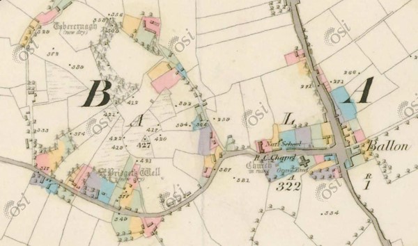
Historic Map 6 Inch Colour (1837-1842) showing Ballon and Ballon Hill (Source: www.osi.ie)
15.3.3.3 Population and Socio-Economic Profile
Population, Demographic and Nationality
The 2016 Census recorded a population of 712 in Ballon. This represents a small increase of 4% from 2011. The previous intercensal period between 2006 and 2011 recorded an increase of 14.77% with the most significant period of growth occurring between 2002 and 2006 (+110%).
Ballon has a young age profile, with 41% of its population recorded in the 0-24 age group in 2016, which is greater than the national figure of 33%. From the 2016 Census it is also apparent the town has a higher proportion than the national average of infants (0-4 years) 9.8% and children (5-12 years) 18%. The 65+ age group represented 8% of the population of the town in 2016 (below the national average of 13.4%).
Non-Irish nationals accounted for 7.6% of Ballon’s population in 2016, which is below the share for the State (11.4%) and the County (10.5%).
Economic Profile
The 2016 Census identified that there were 319 persons in the labour force i.e. aged 15 years and over who were able to work; excluding students, retired, those looking after family or unable to work due to illness or disability. Of this labour force 87.8% were in employment (280 persons).
At 24.6%, professional services were the biggest sector of employment, followed by commerce and trade (23.2%), and manufacturing industries (16.1%). The building and construction sector is also a significant employer for Ballon (9.6%).
The unemployment rate for Ballon in 2016 stood at 12.2%, which was comparable to the figure for the state of 12.9%. Persons not in the labour force comprised of 8.5% retired, 13%, students (aged 15yrs and over), with 5% unable to work due to permanent sickness or disability, and 9% were categorised as looking after home/family.
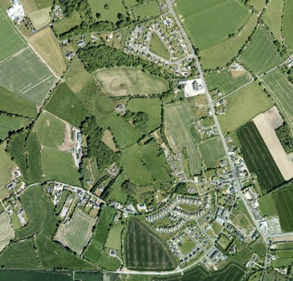
Aerial imagery of Ballon captured between 2013-2018 (Source: www.osi.ie)
15.3.3.4 Housing
A total of 232 households were recorded in Ballon in the 2016 Census, 70% of which were owner occupied. Of this number, one and two-person households comprised 43% of all households, which was below the national figure of 52%. Over half of the town’s housing stock (59.7%) was constructed from 2001 to 2010.
The housing target for Ballon identified in the Core Strategy in Chapter 2 is 62 new residential units over the Plan period from 2022-2028. It is the policy of the Council to encourage the provision of additional housing within Ballon including the completion of Laraghbeg an unfinished housing estate in the town. The Plan will also promote a policy of consolidation focused on localised growth through the development of infill / brownfield lands and mixed use on town centre expansion lands . All development shall respect the character and setting of the town and make a positive contribution to its built environment.
15.3.3.5 Social Infrastructure
Active community-based groups have contributed significantly to the social, community and cultural development of the town. A variety of services and local facilities are provided and include:
- Ballon Community Centre which provides a range of social, cultural, educational and care services.
- Ballon Business and Training Service (old school building) providing training courses as well as room hire for meetings, classes, fitness, hobbies etc.
- Sports facilities include Ballon GFC and Burrin Celtic Football Club located outside and to the west of the settlement, off the Fenagh Road.
- Ballon National School which serves the town and its surrounding catchment, accommodating 280 pupils. The town is also serviced by a Community Childcare Facility.
- Riverdale Nursing Home to the west of the settlement and off the N80.
- A new post office which opened in 2019.
- A community Shop - Siopa Glás on Main Street.
- St. Peter and Pauls Church is located within the town with the cemetery located at the southern end of the town.
15.3.3.6 Economic Development
Ballon is designated a level 3 Small Town under the Retail Hierarchy for the County. It has a more limited retail role and function than higher order settlements, with provision typically restricted to services and convenience shopping.
There are two public houses, a convenience store/grocer, two take-aways, in the town, as well as a café, a hardware store, and a hair salon. There are two service stations on either end of the town to the north and south. In addition to serving passing traffic on the N80, the service stations also have an important function as local convenience stores, with one accommodating the town’s post office. A commercial premise providing stonecutting services also operates from Main Street.
In order to consolidate and strengthen the Level 3 status of the town, commercial and retail development should be located within Ballon’s town centre area, which is focused along Main Street and Church Street.
15.3.3.7 Vacant / Derelict Units and Sites
Vacancy, dereliction, and unfinished sites can have an adverse effect on the visual amenity of a town. In 2016, 4% of residential properties were recorded as vacant in Ballon. Commercial vacancy is evident in the town on Main Street and on the Fenagh Road but is not extensive.
15.3.3.8 Regeneration/Redevelopment Opportunities
The Council promotes and supports the use of previously developed brownfield and infill sites within the established built footprint of Ballon, as well as the redevelopment of existing sites and buildings. This will contribute to:
- Securing more compact and sustainable growth.
- Enhancing the public realm and overall character and appearance of the town.
- Retaining and increasing vibrancy and vitality in the town centre, including viability for local services, shops, and public transport.
- Increased opportunities for sustainable travel such as walking and cycling.
New development proposals on brownfield and infill sites must be accompanied by a Site Brief. The Site Brief must demonstrate how a proposal incorporates principles of good urban design and placemaking as contained in Chapter 12, as well as compliance with national policy and guidance on the achievement of compact growth.
15.3.3.9 Intervention Area - Laragh Beg Site
This site occupies a prominent position within the existing built environment of the town, with dual frontage onto Main Street (N80) to the east and onto Ballykealey Lane (L2035-0) to the west. It has an area of c. 1.2ha with permission for 21 no. residential units and comprises part of an unfinished residential development of 13 no. completed and occupied houses. The site is vacant, underutilised, fenced off to prevent access, and detracts from the character and appearance of the area. It is an objective of the Council to seek completion of this site which has potential to deliver new residential development that will harness the opportunity of a prime location next to the town centre, the local primary school and community centre.
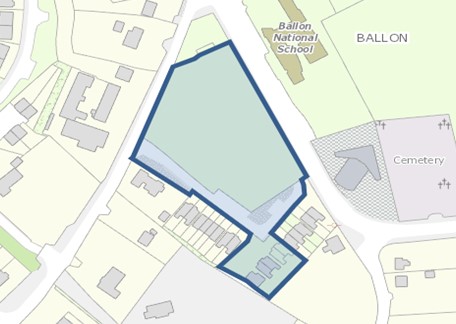
Map 15.3.3.1: Intervention Area – Laragh Beg Site
15.3.3.10 Movement and Transport
The N80 traverses the town and is a busy commuter route, providing direct access to the southeast region (Rosslare Port). The interchange for the N80 and M9 is 6km to the northwest of the town at Rathcrogue. The N80 also functions as an important route in the County for traffic driving between Ballon and Carlow Town.
The town’s location on the N80 and proximity to the motorway interchange, combined with more recent development and growth in the settlement, have resulted in high traffic volumes through Ballon.
As a result of Brexit and with an associated increase in freight through Rosslare Port, there is potential for traffic volumes to increase through Ballon beyond normal growth patterns. The provision of a future N80 bypass, to facilitate local traffic safety and providing a higher standard of access between Rosslare and the M9 interchange, is required for Ballon to ensure sustainable long-term development.
Car parking in Ballon is predominantly provided on-street and along Main Street. This services residential, commercial properties and the National School. A pedestrian (zebra) crossing is located on Main Street beside the National School.
In terms of public transport, the Bus Eireann service along Route 132 between Wexford and Dublin, serves Ballon. This bus route also links Ballon with other towns in the County, namely Tullow and Rathvilly. Wexford Bus also provides regular scheduled bus services, and Ballon is a stop on their Wexford Town to Carlow Town Route 376.
15.3.3.11 Water and Environmental Services
From 2020 Irish Water data, the existing design capacity of the Ballon Wastewater Treatment Plan is 1,200 PE and has an available spare capacity of 483 PE.
Ballon is serviced by the Central Regional Water Scheme.
Domestic, commercial and industrial waste are collected and disposed from Ballon by private operators. Ballon Recycling Bring Bank is located off the Fenagh Road and caters for the collection of beverage cans and glass bottles/jars. The Council encourages recycling and the minimisation of waste through its environmental education programme and the Green-Schools programme.
15.3.3.12 Flood Risk Management
The flood risk mitigation measures and justification tests for Ballon are detailed in Section 7.7 and Section A.1 of the Strategic Flood Risk Assessment (SFRA) prepared as part of this County Development Plan (See Appendix III). General guidance on development management and flood risk is set out in Section 6 of the SFRA.
15.3.3.13 Public Realm
The visual appearance and general attractiveness of the environment of Ballon has in large part been due to significant community effort and initiatives within the town.
The Council in co-operation with local communities, businesses and other relevant stakeholders are seeking to continually improve the physical presentation and appeal of many towns in the county such as Ballon, both through the planning process, initiatives such as Pride of Place, County Tidy Towns, and through funding from the Town and Village Renewal Scheme. In 2017 Ballon was one of a number of project areas in the county awarded funding under the Town and Village Renewal Scheme.
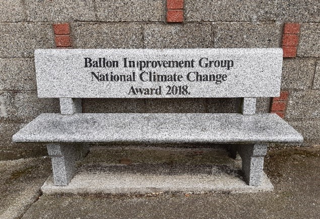
Ballon also received a Tidy Towns Community Climate Action Award in 2018, a competition sponsored by the Department of Communications, Climate Action and Environment. The award recognises the positive contribution the local community in Ballon are making in addressing climate change through their Tidy Town's Activities.
This Plan will support any funding applications under the Town and Village Renewal or similar schemes that would enhance the public realm, built environment, and environmental quality of Ballon.
15.3.3.14 Natural Heritage
There are no SACs or pNHAs within the development boundary of Ballon. The River Slaney is c. 3km east of the settlement and is a designated Special Area of Conservation (Slaney River Valley SAC, Site Code 000781) and a proposed Natural Heritage Area (pNHA). A tributary of the River Slaney flows around the western and northern sides of Ballon Hill and crosses the northern end of the town at Ballykealy Bridge on the N80.
15.3.3.15 Architectural Heritage
Ballon is an historic settlement, having originally formed part of the (former) Ballykealy estate. The original 300-acre estate of Ballykealy was the seat of the Lecky Family from 1649, when Cromwell granted lands at Ballykealy along with lands at Kilnock, Carlow. The estate remained in the Lecky Family until 1953 and was then sold to the Land Commission.
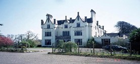
Ballykealey House (Source: NIAH www.buildingsofireland.ie)
Ballon contains a number of structures and features which are recorded in the Record of Protected Structures, and by the NIAH (See Table 15.3.3.1). Chapter 10 of this Plan outlines policies and objectives for protecting architectural heritage within the county.
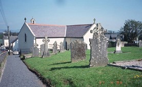
St. Peter and Pauls Catholic Church (Source: NIAH www.buildingsofireland.ie )
|
RPS |
NIAH Ref |
Description |
Address |
|---|---|---|---|
|
CW4
|
10301309
|
Detached Catholic church, c. 1820.
|
St. Peter & Paul’s Catholic Church, Ballon |
|
CW9 |
10301306 |
A tudor-gothic revival house designed by Thomas Cobden about 1830. |
Ballykealy House |
|
CW109 |
10301308 |
A four-bay, two-storey, gable-ended house dating from circa 1850, |
Joe Doyle’s Lounge, Main Street, Ballon |
|
CW110 |
|
A nine-bay, single-storey, national school of circa 1890 |
Old National School, Ballon |
|
CW136 |
10301307 |
Ballon Garda Station was built about 1835 and is a five-bay, two storey building. |
Garda Station, Ballon |
|
CW137 |
|
A walled garden with a fine, granite wall. The garden is situated to the South-East of Ballykealey House close to Ballykealy bridge. |
Walled Garden, Ballykealy, Ballon |
|
CW138 |
|
The burial ground of the Lecky family of Ballykealy. It consists of a high wall with a pointed entrance surmounted by a Celtic cross. |
Ballykealy Burial Ground |
Table 15.3.3.1: Protected Structures and NIAH Listings for Ballon
15.3.3.16 Archaeology
Recorded monuments in Ballon are outlined in Table 15.3.3.2. There is a strong archaeological presence in the area, with Ballon Hill being recognised as one of the most important burial sites during the Bronze Age period in Ireland.
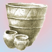
Image of urns found on Ballon Hill (Source: www.ballonvillage.com)
From 2200 BC Ballon Hill was a focal point for burial in the south east of the county and is one of the only known barrow cemeteries in the region. At 130 metres above sea level, the hill provides extensive views of the surrounding countryside. Refer to Chapter 10 of this Plan which outlines policies and objectives for protecting archaeology within the county.
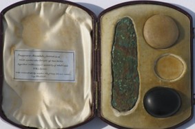
Razor-knife and 2 of 3 polished pebbles (supposed amulets) in bespoke 19th century display case found in cist on Ballon Hill (Source: Carlow County Museum)
|
Ref. No |
Address |
Item |
|---|---|---|
|
CW013-065 |
Ballon |
Flat Cemetery |
|
CW013-066 |
Ballon |
Ritual Site Holy - Well |
|
CW013-067 |
Ballon |
Enclosure |
|
CW013-068 |
Ballon |
Enclosure |
|
CW013-069 |
Ballon |
Ritual site - holy well |
|
CW013-070001 |
Ballon |
Church |
|
CW013-070002 |
Ballon |
Graveyard |
|
CW013-071001 |
Ballon |
Barrow - Ring Barrow |
|
CW013-071002 |
Ballon |
Children’s Burial Ground |
|
CW013-116 |
Laragh |
Ring Ditch |
|
CW013-124 |
Ballon |
Hilltop Enclosure |
Table 15.3.3.2: Recorded Monuments in Ballon
15.3.3.17 Land Use Zoning
Lands within the development boundary of Ballon are zoned for various uses. Zoning objectives are contained in Chapter 16 Development Management Standards.
15.3.3.18 Ballon - Policies
The policies set out in this section for Ballon are in addition to policies and objectives included in all other chapters of this Plan, and therefore should be read in conjunction with same, including the Development Management Standards in Chapter 16.
Settlement Form and Function
It is the policy of the Council to:
| BA. P1: | Support the role of Ballon by facilitating development that will contribute to the character and service function of the town and complement and enhance the quality of its built and natural environment. |
| BA. P2: | Encourage and promote development within the town which is of a high standard of design, has an appropriate mix of uses, enhances the built environment and character of the town and delivers a high-quality built environment. |
Regeneration/Redevelopment Opportunities
It is the policy of the Council to:
| BA. P3: | Promote and support the use of previously developed brownfield, infill and backland sites in Ballon and to continue to identify regeneration opportunities in the town during the lifetime of this Plan. |
| BA. P4: | Encourage the redevelopment and regeneration of the Laragh Beg Site (See Map 15.3.3.1) with appropriate residential development that capitalises on its central location in the town and makes positive contribution to the character and appearance of the area, integrating with completed housing and utilising high-quality urban design and placemaking. |
Economic Development
It is the policy of the Council to:
| BA. P5: | Encourage the provision of retail and services in the town centre to consolidate and strengthen the role of Ballon in meeting the needs of its population and its rural hinterland. |
| BA. P6: | Facilitate and encourage the expansion of established enterprises operating in Ballon, to promote additional enterprise and employment opportunities on appropriately zoned land and to ensure that future development is compatible with the character, scale and function of the town. |
| BA. P7: | Support the provision of co-working spaces within the town centre facilitating the establishment of new businesses and remote working opportunities for residents of the town. |
| BA. P8: | Encourage and support the development of sustainable tourism in the town, including the provision of heritage trails. |
Movement and Transport
It is the policy of the Council to:
| BA. P9: | Maintain and improve where appropriate the local road network (street) and to improve the quality, aesthetics and width, where appropriate, of all footpaths in the town, to promote active travel measures and to improve access for mobility impaired. |
| BA. P10: | Promote and facilitate the development of walkways and cycleways at appropriate locations throughout the town to encourage sustainable transport. |
| BA. P11: | Enhance Ballon road network as necessary and to seek to reserve land for the provision of a new orbital / relief road in accordance with the requirements of Section 5.5.9 and Policy IIP1. |
Housing
It is the policy of the Council to:
| BA. P12: | Seek to encourage and facilitate the re-use and regeneration of Laragh beg (unfinished estate) for residential purposes as indicated on Map 15.3.3.1. |
| BA. P13: |
To facilitate low-density residential development (max no. 10 units) on new residential zoned lands adjoining The Oaks, subject to the appropriate phasing of the scheme and high-quality design and siting considerations. The scheme shall also provide high-quality landscaping and public open space provision and shall comply with all other proper planning and sustainable development considerations as appropriate. |
| BA. P14: | Support and encourage residential / mixed use development on under-utilised and/or vacant lands including ‘infill’ and ‘brownfield’ sites, subject to a high standard of design and layout being achieved, and compliance with proper planning and environmental considerations. |
| BA. P15: | Ensure that future growth is balanced and sustainable and is appropriate to the scale, size and character of the existing town. |
Social Infrastructure
It is the policy of the Council to:
| BA. P16: | Seek to enhance and provide recreational and community amenity facilities in Ballon to meet the needs of the residential population and surrounding rural hinterland. |
| BA. P17: | Support the development of zoned open space and amenity lands for the provision of appropriate amenity facilities for the local community. |
Water and Environmental Services
It is the policy of the Council to:
| BA. P18: | Liaise with and support Irish Water to ensure adequate water services are in place to meet the development needs of Ballon within the Plan period. |
Flood Risk Management
It is the policy of the Council to:
| BA. P19: |
Manage flood risk in Ballon in accordance with the following provisions: 1. Development of areas zoned existing residential within Flood Zone A and B shall be:
Any future development should be subject to an FRA which should follow the general guidance provided in Section 6 of the SFRA and must specifically address the following:
2. Developments within areas of the institutional zoning (WWTP) within Flood Zone A and Flood Zone B shall be in accordance with the following provisions: Any future expansion of the WWTP should be subject to an FRA which should follow the general guidance provided in Section 6 of the SFRA and must specifically address the following:
3. Development at Ballon Garda Station within area zoned Community/Education and within Flood Zone A and B shall be in accordance with the following provisions: Any future development should be subject to an FRA which should follow the general guidance provided in Section 6 of the SFRA and must specifically address the following:
|
Public Realm
It is the policy of the Council to:
| BA. P20: | Continue to support public realm improvements in the town and the work of local community groups, including where appropriate, the provision of appropriate signage, public seating, open space, hard and soft landscaping, and improvements to the public road and footpath network. |
| BA. P21: | Promote and support the utilisation of available funding and the implementation of projects or schemes for which funding has been received that would contribute towards the maintenance and improvement of the public realm of the town. |
Built and Natural Heritage
It is the policy of the Council to:
| BA. P22: | Support the retention of buildings with architectural merit, significant architectural features, historic /heritage structures and archaeological sites that contribute to the towns character and setting. |
| BA. P23: | Protect individual trees, groups of trees, hedgerows and stone walls in so far as possible on all approach roads and within the town which contribute significantly to the character and visual amenity of the town. |
| BA. P24: | Require development proposals to outline how they integrate / respond to green infrastructure and contribute to the development and protection of green infrastructural assets in the town and wider area. |
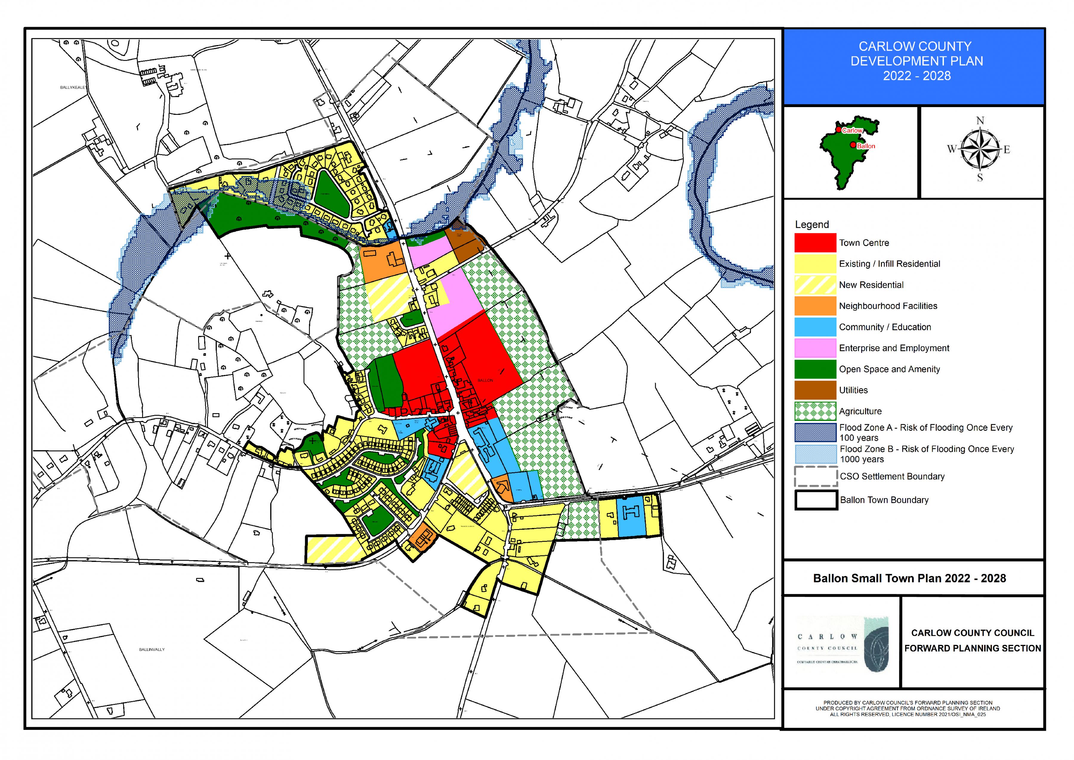
Ballon Land Use Zoning Map
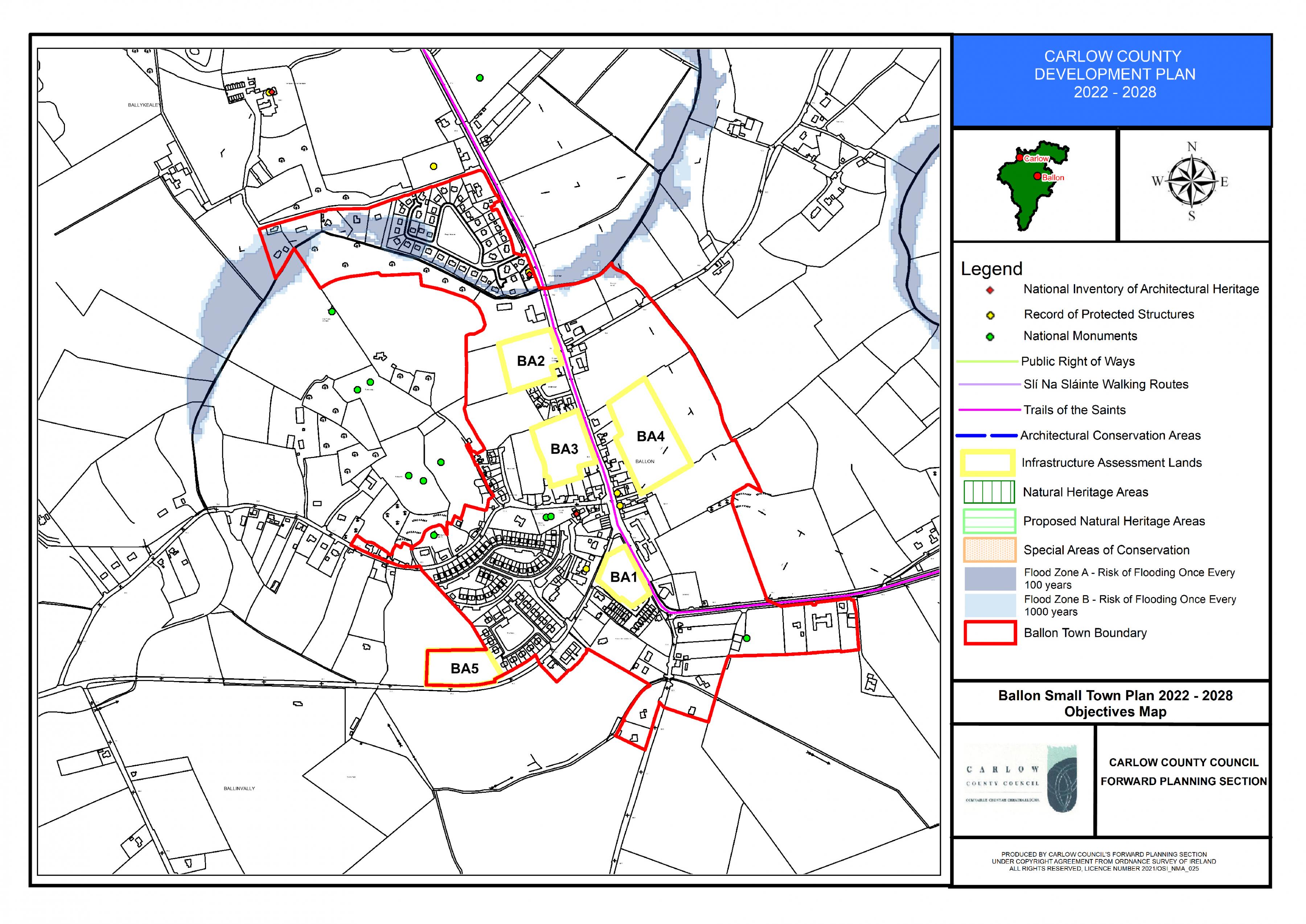
Ballon Objectives Map