Chapter 15: Hacketstown Plan
Vision
To seek and promote economic and physical renewal and regeneration in Hacketstown, facilitating healthy placemaking while accommodating population growth, promoting employment opportunities within the town, addressing vacancy and dereliction thereby improving quality of life, whilst pursuing a continued pattern of high quality development that respects the inherent characteristics of the natural and built environment.
15.3.5 Hacketstown Plan
15.3.5.1 Location
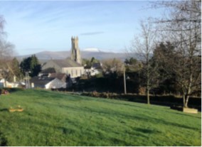
Hacketstown is located in the north east of County Carlow, on the border with County Wicklow. The town is located in a scenic area, with Eagle Hill a dominant feature to the south of the town and views of the Wicklow Mountains in the backdrop. Hacketstown is located on the main regional roads (R747 and R727) from the East Coast to the Midlands and is proximate to Tullow, Baltinglass and Tinahely. Hacketstown is the southern gateway to the major tourist attractions of County Wicklow. The town is located c.27 kilometres from Carlow Town.
|
Hacketstown |
|
|---|---|
|
Position in Settlement Hierarchy |
Small Town |
|
2016 Population |
597 |
|
2011 Population |
600 |
|
% Change 2011-2016 |
-0.4% |
|
Households |
228 |
|
Committed Units not yet Built |
4 |
|
Core Strategy Housing Allocation |
56 |
|
Population Projection 2028 |
724 |
|
Education Facilities |
Primary and Secondary Schools including Childcare / Pre School Facilities |
|
Community Facilities |
Community Centre, GAA Facilities located outside the town |
|
Architectural Conservation Areas |
None |
|
Protected Structures |
7 no. |
|
Zone of Archaeological Potential / NMR |
2 no. Sites |
|
Natura 2000 Sites |
River Dereen located on northern boundary is a tributary of the River Slaney (SAC -Site Code 000781) |
|
Strategic Flood Risk Assessment |
Lands located within Flood Zones Open Space and Amenity |
|
Water Services Infrastructure / Capacity |
Sufficient Capacity exists in Water and Wastewater Infrastructure to accommodate development |
15.3.5.2 Settlement Form and Function
Hacketstown main street reflects the character of a traditional small Irish town that developed as a crossroads town between the R747 and the R727. It operates primarily as a goods and services centre and provides a restaurant, post office, credit union, fire station, pharmacy, primary and secondary schools and a community centre. The town centre also contains several public houses and fast-food stores. To the north of the town centre are significant underutilised industrial lands which detract from the appearance of the town. To the west, south and east of the town centre the majority of development comprises of housing areas.
SuperValu is the main convenience anchor retailer in the town, located on Main Street Upper at the junction with Mill Street. There is also a smaller convenience store (Londis) located in the petrol station on Moffetts Lane. Main Street also accommodates a pharmacy, butchers, barbers and hairdressers, with a large hardware shop.
Along secondary streets, there is a high rate of vacant buildings, this is particularly evident along Water Street/ Moffett’s Lane. Large derelict and vacant sites are located close to the junction of Main Street and Mill Street and impact significantly on the vitality, viability and character of this road including the former Perry Oil Company on Mill Street. Mill Street located just off the Main Street comprises a mix of commercial and residential premises.
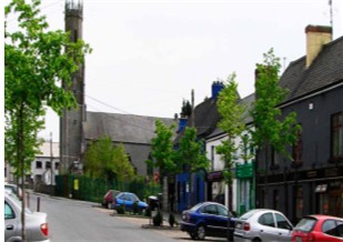
Main Street Hacketstown
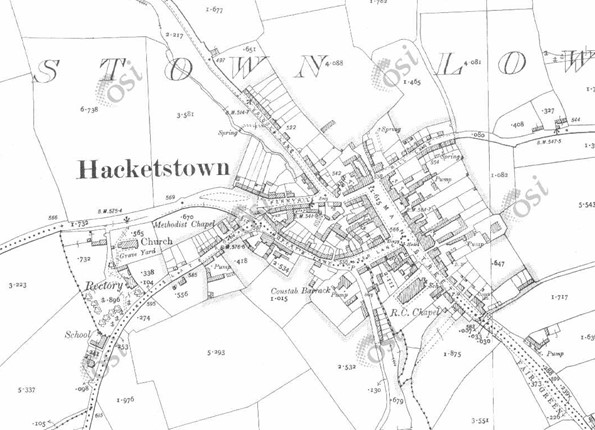
Historic Map 25 Inch (1888-1913) of Hacketstown (Source: www.osi.ie)
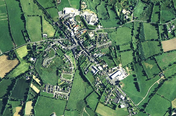
Aerial imagery of Hacketstown captured between 2013-2018 (Source: www.osi.ie)
15.3.5.3 Population and Socio – Economic Profile
According, to the 2016 data, Hacketstown has a population of 597 representing an decrease of -0.4% from 2011 (600). Population levels have been consistently decreasing in the town with an overall population decline of 16% (110 persons) since 1991.
Population Demographic / Nationality
The 0-24 age group represents 35% of the population which is in excess of the national average of 33%. 12% of the population were in excess of 65 years of age which is similar to the national average. 53% of the population were aged between 25-64 years of age.
Approximately 7% of the population comprise non-Irish nationals, a figure substantially below the National (11%) and County (11%) average.
Economic Profile
2016 CSO data indicates that there were 292 persons in the labour force (aged 15 years and over who were able to work; excluding students, retired, those looking after family or unable to work due to illness or disability). Of those in the labour force 66% were in employment (193 persons). The biggest sectors of employment were in commerce and trade (25%), followed by manufacturing industries (16%) and professional services (15%). Less than 600 jobs were recorded in the Hacketstown ED in 2016 (POWCAR data).
Hacketstown had an unemployment rate of 34% (2016 data), which was more than two and a half times the national average (13%). Of persons not in the labour force, 38% were retired, 25% were students (aged 15 years and over) and 12% are unable to work due illness or disability. A further 25% were categorised as looking after home/family.
Within the Hacketstown ED the Pobal HB Deprivation Index identifies over 50% of the population residing in the ED as disadvantaged or very disadvantaged.
15.3.5.4 Housing
There were 228 households recorded in the 2016 Census. One and two person households made up 57% of all households. 57% of the units were also classified as owner occupied. 20% of all housing units were completed between 2001-2010.
The Core Strategy, as described in Chapter 2 of this Plan gives a target of 56 new residential units in the town between 2022-2028. Permission currently exists for a small infill scheme of 4 units on Penny Lane. Two no. residential units remain to be completed in Fairgreen off the Main Street.
The priority objective of the Council over the period of this Plan is to facilitate regeneration of the town core area, building on existing opportunities to reduce vacancy and dereliction on the Main Street, improving the public realm and upgrading pedestrian linkages. A significant proportion of new residential opportunities in Hacketstown will therefore be encouraged within the existing town centre zoned area including intervention areas no.2 and 3, together with infill opportunities in existing residentially zoned areas. Slate Row new residential zoning will accommodate a maximum of 20 no. units over the period of this Plan and will be subject to a detailed masterplan providing for the appropriate phasing of development and provision of supporting community / open space facilities. A max of 13 number units will considered on lands zoned new residential off Eagle Hill Road.
15.3.5.5 Services and Facilities
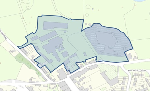
Primary education needs are catered for by St. Joseph’s National School. The town is also served by the Coláiste Eoin secondary school. The town has a Montessori pre-school at Church Hill. Adult learners may avail of adult education in Coláiste Eoin. Hacketstown Health Centre provides healthcare services in the town. A playground has been permitted within the town at Mountain View, while GAA facilities are located outside the town boundary.
15.3.5.6 Economic Development
Hacketstown is currently an unemployment blackspot and apart from local services and community facilities there are few other significant employment industries located within the town. The Retail Hierarchy of Carlow County designates Hacketstown as a level 3 small town. A level 3 town generally has a more limited retail role and function than other towns in the area. Retail is often limited to the provision of services and convenience shopping. Retail and commercial development should generally be located within the town centre area of Hacketstown in order to consolidate and strengthen the role of retail. Retail and commercial development in the town of Hacketstown should take the planned population growth into consideration.
As a smaller town it is to perform important local level retail, residential, social, leisure, service and amenity functions. Targeted sectors in the area should include engineering, hospitality, local retailing services, agriculture/agri-foods, tourism, manufacturing, small-scale commercial enterprises, indigenous industry and micro enterprise.
15.3.5.7 Vacant / Derelict Units and Regeneration Sites
Vacancy and dereliction have an adverse effect on the visual amenity of the town. In 2016, 15% of residential properties were recorded as vacant. Commercial vacancy is also evident within the town centre. There is a visibly high rate of vacant and derelict commercial and residential units on Main Street particularly along the east side of the street , with many of the frontages dilapidated, impacting negatively upon the character and vitality of the town.
15.3.5.8 Regeneration/Redevelopment Opportunities
The Council promotes and supports the use of previously developed brownfield and infill opportunity sites within the established built footprint of Hacketstown, as well as the redevelopment of existing sites and buildings. This will contribute to:
- Securing more compact and sustainable growth.
- Enhancing the public realm and overall character and appearance of the town.
- Retaining and increasing vibrancy and vitality in the town centre, including viability for local services, shops, and public transport.
- Increased opportunities for sustainable travel such as walking and cycling.
Development proposals on brownfield, infill, and backland sites must be accompanied by a Site Brief. The Site Brief must demonstrate how a proposal incorporates principles of good urban design and placemaking as contained in Chapter 12, as well as compliance with national policy and guidance on the achievement of compact growth.
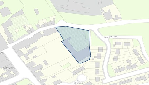
15.3.5.9 Intervention Area 1 – Factory Sites
This intervention area at the northern end of the town encompasses a number of vacant and underutilised factory buildings, structures and lands, with previous occupants including Duffy Meats, Kerry Co.Op. Creameries Ltd., and Kepak. The vitality and vibrancy of the town was significantly affected by the closure of factories on the sites, which had shaped its industrial core and determined its residential pattern. The decline of industrial uses at this location had serious implications for employment opportunities in the town, a reduced demand for local services, and reduced investment in commercial activity and private housing.
Extending to c. 4.9ha, the intervention area is sizeable and highly visible brownfield land that detracts from the local built environment. Its factory buildings, structures and vacant and underutilised appearance presents a poor-quality streetscape to Bridge Street, Main Street and Mill Street, at what is an important northern gateway into the town.
The intervention area represents a significant redevelopment opportunity for the town that could:
- Capitalise on a centrally located and accessible area in the town.
- Deliver a range of higher end employment uses;
- Rejuvenate the town by bringing back much needed vitality and vibrancy, including social and economic viability.
- Significantly enhance the overall character and public realm of the town.
Map 15.3.5.1: Intervention Area 1 – Factory Sites
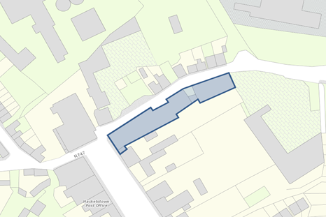
15.3.5.10 Intervention Area 2 – Former Duffy Steel Site
The Former Duffy Steel Site (c. 0.4ha), now occupied by Steel and Spares Ltd., is situated just east of the town centre and is accessed from Mill Street. It adjoins the Mountain View residential development to the east, and the rear of properties fronting Main Street to the west. It includes workshop and storage buildings at its southern end, and an open yard area at its northern end fronting Mill Street. The industrial character and use of the site detract from the built environment and local streetscape, and is not compatible with adjoining residential development.
The site has potential to take advantage of a prime and accessible location in relation to the established built form of the town. It represents a redevelopment opportunity that could:
- Deliver more compatible mixed / town centre uses for the area;
- Make a more positive contribution to the local built environment;
- Enhance the vitality and vibrancy of the town; and,
- Facilitate the creation of potential connections to adjoining residential development and to town centre backlands.
Map 15.3.5.2: Intervention Area 2 – Former Duffy Steel Site
15.3.5.11 Intervention Area 3 – Main Street / Mill Street Junction Site.
Situated at the junction of Main Street and Mill Street, this visible corner site includes vacant and derelict 2-storey commercial buildings that detract from the public realm of the town. The northern elevation facing Mill Street directly adjoins the street and includes blocked up windows and doors. The Main Street elevation to the west includes a vacant ground floor retail unit. The site has an area of c. 0.1ha.
The existing vacant and derelict buildings on this prominent corner site present a redevelopment opportunity in a central town centre location. There is potential to take advantage of the location with a town centre/mixed use scheme that could contribute to:
- Rejuvenating the appearance of the public realm and streetscape; and,
- Reintroduce some vitality and vibrancy to the town centre with new residential and/or commercial uses.
Map 15.3.5.3: Intervention Area 3 – Main Street / Mill Street Junction Site
15.3.5.12 Movement and Transport
Hacketstown is located at the crossroads of two regional roads, the R747 from the east coast to the midlands, the R727 which serves Carlow and three local roads (Slate Row, Mill Street and L6007). Within the town centre car parking is generally provided on street. The road network and associated car parking affects the visual and landscape character of the town by increasing the traffic and carriageway elements while reducing the prevalence of softer elements. Introduction of traffic calming measures, localised road improvements and the introduction of public realm enhancements including improved upgrading and maintenance of public footpaths would enhance the visual amenity and character of the town.
JJ Kananagh and Sons provide a bus service from Hacketstown to Carlow via Baltinglass, Rathvilly and Tullow. This service runs twice a day. Bus Eireann also provides a limited service in the town, route 132, which connects Rosslare to Dublin.
15.3.5.13 Water, Drainage and Environmental Services
From 2020 Irish Water data, the existing design capacity for the Hacketstown Wastewater Treatment Plan is 2000 PE, and has an available spare capacity of 1,219 PE.
Hacketsown is supplied by the Carlow North Regional Water Scheme. Sufficient capacity exists in the Hacketstown Water Supply network to accommodate likely future demand.
Domestic, commercial and industrial waste are collected from Hacketstown by private operators. There is also a Bring Bank located at Hacketstown Community Hall which accepts beverage cans and glass bottles and jars. The Council encourages recycling and the minimisation of waste through its environmental education programme and the Green-Schools programme.
15.3.5.14 Flood Risk Management
The flood risk mitigation measures and justification tests for Hacketstown are detailed in Section 7.19 and Section A.7 of the Strategic Flood Risk Assessment (SFRA) prepared as part of this County Development Plan (See Appendix III). General guidance on development management and flood risk is set out in Section 6 of the SFRA.
15.3.5.15 Public Realm
The main street area reflects a traditional small Irish Town with two storey buildings overlooking the Main street. Key built heritage features include St. Brigid’s Church and St. John the Baptist Church. The architecture of the town is mainly in a vernacular style and most buildings date from the 19th century onwards. While there have been some improvements to the town centre including tree planting and high-quality street furniture, the public realm is significantly impacted by a high level of vacancy and dereliction with dilapidated frontages detracting significantly from the towns vitality and vibrancy. Improvements to the centre of the town could be achieved through the introduction of a building improvement scheme, occupancy and upgrading of vacant and derelict units, attractive window displays, an improved signage programme to reduce clutter and high-quality finishes to the public realm including footpaths, seating, hard and soft landscaping.
The Council in co-operation with local communities, businesses and other relevant stakeholders are seeking to continually improve the physical presentation and appeal of many towns in the County such as Hacketstown, both through the planning process, initiatives such as County Tidy Towns, and through funding from the Town and Village Renewal Scheme.
15.3.5.16 Natural Heritage
The town is situated within an attractive natural setting surrounded by woodland and mountains to the east. These surroundings contribute significantly to its overall attraction and environmental quality. Landscaping measures within the Town also contribute to the vitality of the Town Centre. The River Derreen is located on the northern boundary of the town centre and offers significant potential as an attractive walking route. This is a tributary of the River Slaney which is a Special Area of Conservation. The River Derry rises to the south of the town with Eagle Hill rising as a dominant feature on the landscape to the south of the town.
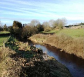
River Derreen Hacketstown
15.3.5.17 Architectural Heritage
The Town Centre is defined by its traditional market square and wide streetscape.
There are a number of buildings of heritage value within the Town which are contained on the Record of Protected Structures (See Table 15.3.5.1). Structures in this record are of special architectural, historical, archaeological, artistic, cultural, scientific, social, technical interest or value. The list includes the Catholic Church of St Bridget, which was built in the early part of the 19th century which houses a penal-time cross and part of a conventional Hay Rick stand at the front. There is also a memorial devoted to those who died during the uprising of 1798, while a 1916 monument has been erected in the green area. Saint John the Baptist Church of Ireland dates from the late 1700s while Hacketstown Bridge dates back to 1825.
|
RPS |
NIAH |
Description |
Address |
|---|---|---|---|
|
CW294 |
10400202
|
A detached, three-bay, single-cell First Fruits church thought to have been built about 1780 with the tower added about 1820. |
St John the Baptist Church of Ireland Church, Hacketstown |
|
CW295
|
10400203
|
A simple, three-bay hall.
|
Methodist Church, |
|
CW296 |
10400205 |
A four-bay, single-cell church of circa 1820. |
St Brigid’s Catholic Church, |
|
CW511 |
10300415 |
An early-19th century bridge. |
Saulsford Bridge, |
Table 15.3.5.1 Protected Structures and NIAH Listings for Hacketstown
St Brigid’s Church Hacketstown
15.3.5.18 Archaeological Heritage
Archaeological sites and monuments are recorded in the Record of Monuments and Places. Hacketstown has just two sites of archaeological significance within the town but the battlefield is of great historic significance. There are a number of significant archaeological sites within the environs of the town including hut and metal working sites at Eagle Hill, Enclosures etc.
|
Ref. No |
Address |
Item |
|---|---|---|
|
CW004-064 |
Hacketstown Lower |
Battlefield |
|
CW005-002 |
Hacketstown Lower |
Earthwork |
Table 15.3.5.2 Recorded Monuments in Hacketstown
15.3.1.19 Land Use Zoning
Lands within the development boundary of Hacketstown are zoned for various uses. Zoning objectives are contained in Chapter 16 Development Management Standards.
15.3.1.20 Hacketstown - Policies
The policies outlined hereunder for Hacketstown are in addition to policies and objectives included in all other chapters of this Plan, and therefore should be read in conjunction with same, including the Development Management Standards in Chapter 16.
Settlement Form and Function
It is the policy of the Council to:
| HT. P1: | Support the role of Hacketstown by facilitating development that will contribute to the character and services function of the town while complementing and enhancing the quality of its attractive built and natural environment by delivering a high-quality standard of design. |
| HT. P2: | Preserve the character of the town by requiring that the height, scale, design and materials of any proposed development respects the vernacular character and distinctive built heritage of the town and does not diminish its sense of place. |
| HT. P3: | To enhance the coherence and integrity of the townscape by reflecting the local vernacular architecture in new buildings and refurbishments of the town centre. |
Regeneration/Redevelopment
It is the policy of the Council to:
| HT. P4: | Promote and support the use of previously developed brownfield, infill, derelict and backland sites in Hacketstown, including the redevelopment of existing sites and buildings, and to continue to identify regeneration opportunities in the town during the lifetime of this Plan. |
| HT. P5: | Encourage the redevelopment of the identified sites (See Maps 15.3.5.1 -15.3.5.3) with appropriate development that delivers higher end employment uses and more compatible town centre for the area and makes a positive contribution to the vitality and vibrancy of the town and its built environment and streetscapes. |
Economic Development
It is the policy of the Council to:
| HT. P6: | Encourage the provision of retail and services to consolidate and strengthen the role of Hacketstown in meeting the needs of its population and its rural hinterland. |
| HT. P7: | Facilitate and encourage the expansion of employment opportunities and enterprises in Hacketstown and to ensure that future development is compatible with the character, scale and function of the town. |
| HT. P8: | Support tourism related uses, activities and amenities that complement the natural and built heritage assets of the area including the River Derreen subject to environmental assessments. |
| HT. P9: | Support the provision of co-working spaces within the town centre facilitating the establishment of new businesses and remote working opportunities for residents of the town. |
Movement and Transport
It is the policy of the Council to:
| HT. P10: | Maintain and improve where appropriate the local road network /streets and to improve traffic safety through localised improvement works including the quality, aesthetics and width, where appropriate, of footpaths in the town, to promote active travel measures and to improve access for mobility impaired. |
| HT. P11: | Promote and facilitate the development of walkways and cycleways at appropriate locations throughout the town to encourage sustainable transport. |
Housing
It is the policy of the Council to:
| HT. P12: | Seek to encourage and facilitate where appropriate the re-use and regeneration of derelict, vacant and underutilised property in the town centre for residential purposes. |
| HT. P13: | Support and encourage residential development on new residential and infill sites subject to a high standard of design and layout being achieved, and compliance with proper planning and environmental considerations. |
| HT. P14: |
Require the submission of a detailed masterplan for new residential development at Slate Row which shall be informed by the preparation of a social infrastructure assessment establishing the need for community facilities to support the proposed and existing residential community. The masterplan shall provide for:
|
| HT. P15: |
To facilitate subject to compliance with proper planning and sustainable development a max. of 13 no. units on lands zoned new residential (1.3ha) off Eagle Hill Road. |
| HT. P16: | Ensure that future growth is balanced and sustainable and is appropriate to the scale, size and character of the existing town. |
Social Infrastructure
It is the policy of the Council to:
| HT. P17: | Seek to enhance and provide recreational and community amenity facilities in Hacketstown. |
| HT. P18: | Support the development of zoned open space and amenity lands for the provision of appropriate amenity facilities for the local community subject to environmental assessments. |
Water and Environmental Services
It is the policy of the Council to:
| HT. P19: | Liaise with and support Irish Water to ensure adequate water services are in place to meet the development needs of Hacketstown within the Plan period and beyond. |
Flood Risk Management
It is the policy of the Council to:
| HT. P20: |
Manage flood risk in Hacketstown in accordance with the following provisions: Development within the existing residential zoning along the steep unnamed stream flowing in culvert through the residential lands shall be:
Any future development should be subject to an FRA which should follow the general guidance provided in Section 6 of the SFRA and must specifically address the following:
|
Public Realm
It is the policy of the Council to:
| HT. P21: | Encourage public realm enhancements to the centre of the town and to facilitate mixed town centre uses to ensure the continued vitality and vibrancy of the town centre. |
| HT. P22: | Continue to support public realm improvements in the town, including where appropriate, the provision of appropriate signage, public seating, open space, hard and soft landscaping and improvements to the public road and footpath network. |
| HT. P23: | Promote and support the utilisation of available funding and the implementation of any projects or schemes for which funding has been received that would contribute towards the maintenance and improvement of the public realm of the town. |
Built and Natural Heritage
It is the policy of the Council to:
| HT. P24: | Support the retention of buildings with architectural merit, significant architectural features, historic /heritage structures and archaeological sites that contribute to the towns character and setting. |
| HT. P25: | Protect individual trees, groups of trees, hedgerows and stone walls in so far as possible within the settlement and on all approach roads which contribute to the character and visual amenity of the town. |
| HT. P26: | Require development proposals to outline how they integrate / respond to green infrastructure and contribute to the development and protection of green infrastructural assets in the town and wider area. |
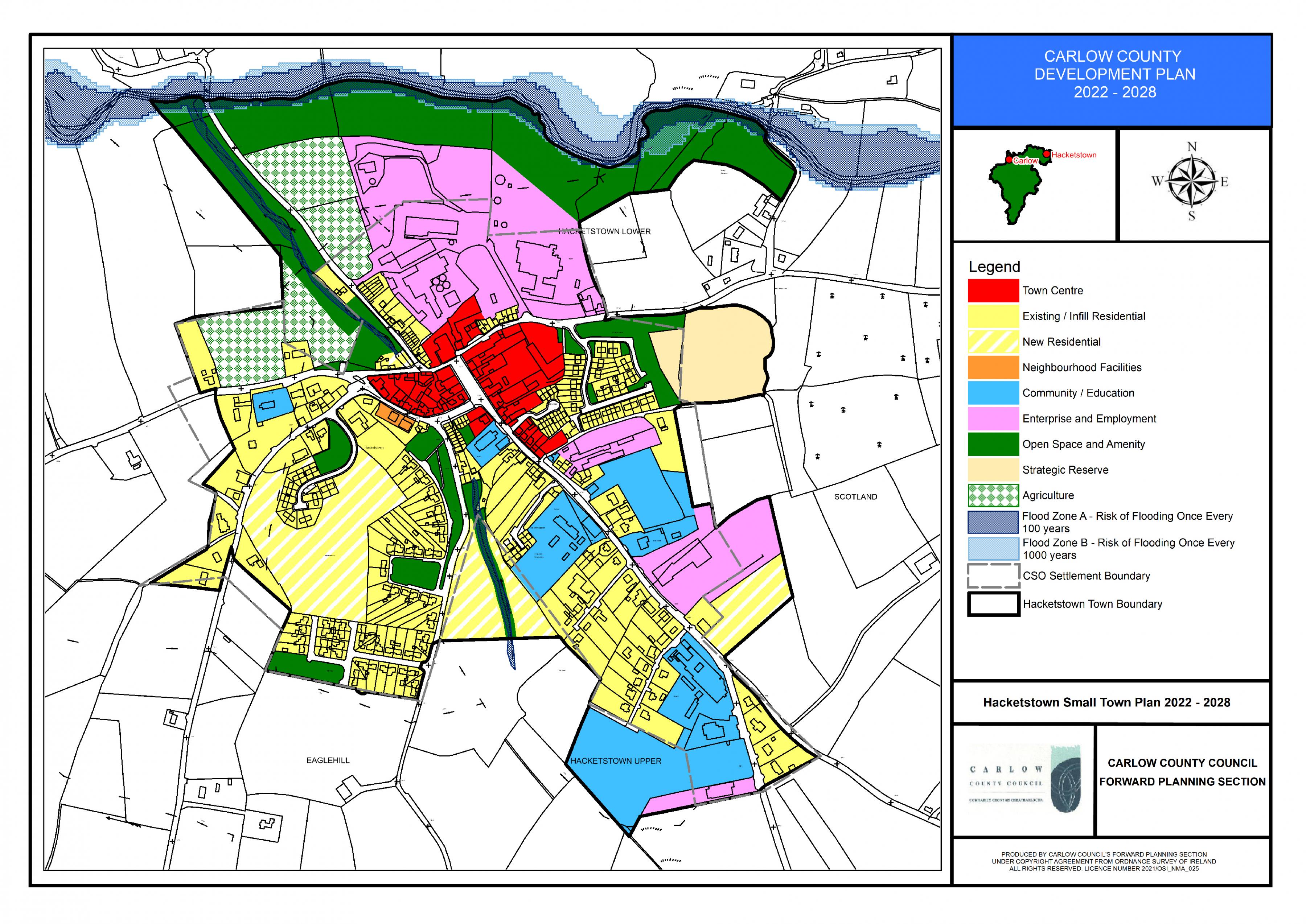
Hacketstown Land Use Zoning Map
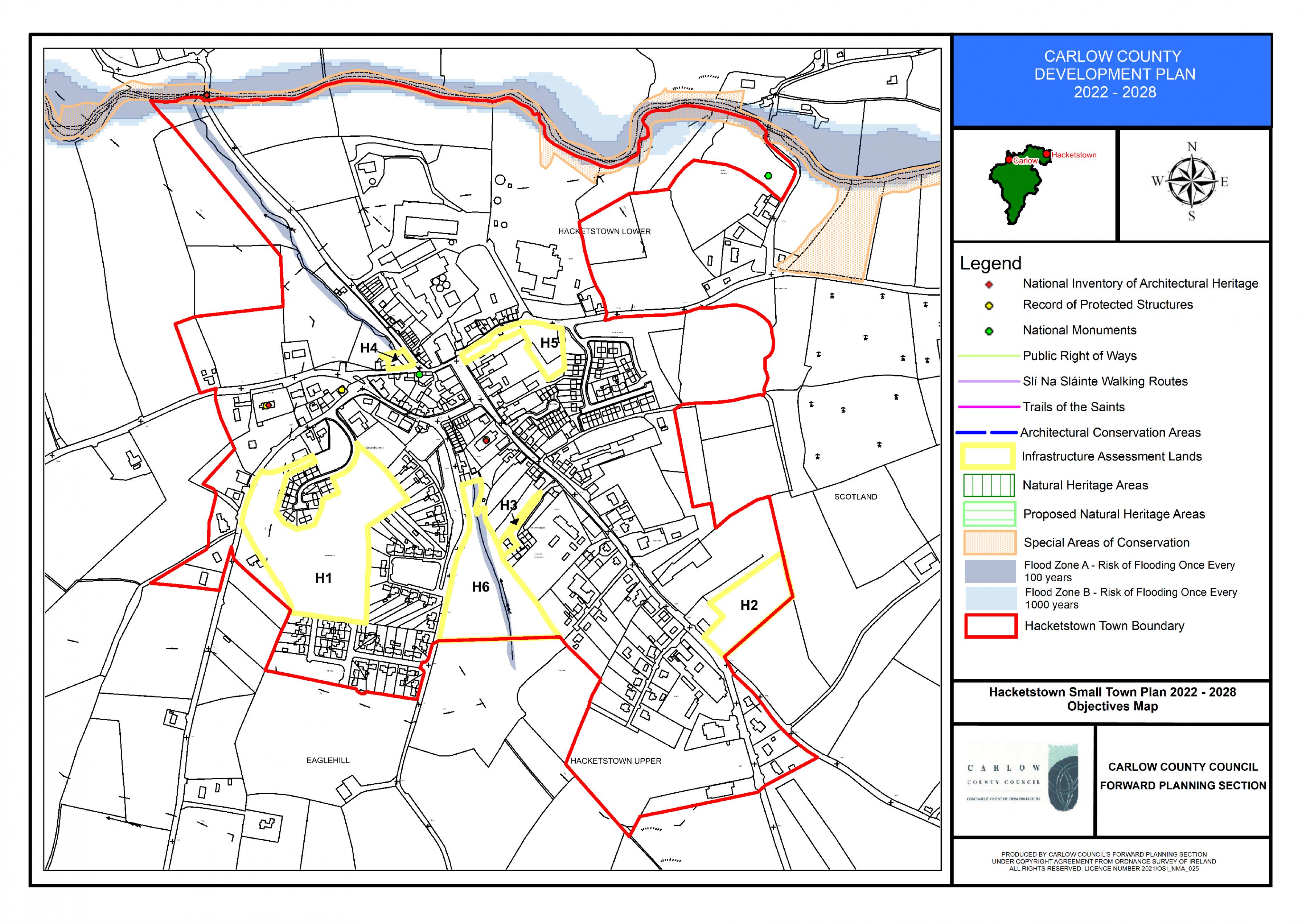
Hacketstown Objectives Map