2. Transport and Movement
The proposed Transport & Movement Strategy will help to strengthen Carlow’s position as a first-class regional town, through investment in sustainable transport measures which provide existing and future residents with a range of healthy, safe and low carbon travel choices.
A well performing transport network underpins the economic, spatial, social and environmental success of Carlow and facilitates the transition to a low carbon and climate resilient local economy. Failure to deliver an efficient transport network that supports sustainable travel acts as a barrier to economic growth, reduces quality of life and has a negative impact on the environment.
Building on Carlow’s strategic location and existing assets, the prioritisation of integrated transport and land use, supported by investment in public transport, active travel networks and shared, low carbon mobility options will improve people’s travel choices and support safe, sustainable and healthy lifestyles.
Transport and Movement – supporting the vision for Carlow Town
The Transport and Movement Strategy has been developed to support the overall vision for Carlow Town Centre where ‘residents, workers and visitors alike will be encouraged, through enhanced connections and improvements in the public realm, to access everything the Town Centre has to offer…. will significantly improve the health and wellbeing of its people, support local business, facilitate tourism and encourage people to live within the Town Centre’.
Our approach is based on developing transport infrastructure, services and behavioural change support that prioritises healthy, active and low carbon travel options for Carlow residents, workers and visitors alike – while reducing car dependency and encouraging opportunities for community interaction through liveable, vibrant and welcoming streets and places. It is grounded in the key principles of the Vision, in particular:
- Principle 3 – Realise the full potential of infrastructure (road, air, rail and water)
- Principle 4 – Promote a high quality of life and wellbeing
- Principle 5 – A Town perceived as an exciting and safe place to live, work and visit
- Principle 7 – Increased Town Centre Footfall
-
Principle 9 – Deliver high quality and person-centred buildings and public realm
Existing Transport Characteristics of Carlow An evaluation of Census 2016 data on the morning commuting (work and education) travel patterns to and from Carlow Town (including Carlow Urban, Carlow Rural, Graiguecullen Urban and Graiguecullen Rural) are summarised as follows: • Over half (62%) of all work and education trips associated with Carlow Town stay within the town’s Urban and Rural Electoral Divisions (EDs), including Graiguecullen. This is due to the combination of commercial activity within Carlow’s both urban and rural areas and the high concentration of schools within Carlow Town Centre. • 8% of trips are to other areas of Carlow County. • 20% of trips are external to County Carlow: 5% to County Kildare; 4% of trips are to County Laois, 3% to Dublin City; 3% to Dublin County; 3% to Kilkenny; and 2% to Wicklow County.
![]()
Figure 1: Trip Destinations from Carlow Town – Graiguecullen Area
The mode share for commuting and education trips for Carlow Town compared to Carlow County and the rest of Ireland, is shown in the following table.
|
Mode |
Carlow Town |
Carlow County |
State |
|---|---|---|---|
|
On Foot |
22% |
15% |
15% |
|
Bicycle |
2% |
1% |
3% |
|
Bus |
2% |
6% |
11% |
|
Train |
1% |
1% |
3% |
|
Car |
72% |
76% |
68% |
Table: Carlow Modal Split, CSO 2016
- A considerable percentage of people (22%) walk as a means of transport in Carlow Town, which is higher than the rest of the county and the state. This reflects the substantial level of local trip made within the town and its environs.
- 2% of trips are made by bicycle, which is comparable to County Carlow and the State average but below national targets of 10% commuting by bike by 2020. High volumes of traffic and limited cycle provision in the Town Centre means cycling within the town is not currently an attractive option. Cycle facilities are provided on many of the wider roads surrounding the Town Centre core, however the cycle lane provision is discontinuous in sections with priority given to vehicular traffic.
- There are low levels of bus and train usage within Carlow. This is typical of a regional town where the private car affords flexibility for making trips and public transport route and frequency options are often limited. The absence of a Town-bus service in Carlow connecting residential areas to the Town Centre, places of employment, education, retail and other services results in the private car being the only viable mode of transport for many people.
- A high number of people in Carlow rely on car usage for commuting and education trips (72%). It is similar to the rest of County Carlow (76%) and the State average (68%) – however this is a higher car mode share compared to the national target of 45% for car commuting trips.
To reduce car mode share from 72% to 45% will require investment in public transport, active travel and shared mobility as viable alternative travel options.
An Integrated Approach to Land Use & Transport Planning – the 10 Minute Town concept
Land use policies which support development within realistic walking/cycling distances from employment, education residential and shopping/entertainment/leisure areas are a key mechanism to support the development of sustainable, healthy and low carbon towns. The 10-minute neighbourhood is a term popular in North America though applied informally in Europe too. It is about creating connected communities – understanding how neighbourhoods work and designing/retrofitting more compact and permeable urban areas to ensure a vibrant, mixed use place, where most trips to school, shops, work, recreation and to public transport are within walking or cycling distance for the majority of residents. This has numerous benefits including reducing the need to travel (which therefore reduces car dependency, emissions, air pollution and congestion) but also promoting physical activity and opportunities for community interaction – creating socially connected neighbourhoods and improving the overall quality of life for residents and visitors. Arup has been commissioned by the Southern Regional Assembly (SRA) to undertake a “10 Minute Town” concept.
which will form part of the Regional Action Plan for Interreg Europe MATCH-UP project. The main constraints and opportunities that have been established during the 10 Minute Town analysis can be summarised as below:
- There is generally a lack of direct access from residential estates to main roads.
- The need to improve existing footpaths, not only for safety reasons, but also to encourage the residents and visitors to walk within their 10-minute catchment rather than rely on cars.
- There is potential to promoting cycling as a means of transport by providing adequate cycling facilities, including parking. • There is potential for new local bus routes and/or increases in frequency for existing routes.
- Carlow Town RVIS is taking into consideration these recommendations, which are included in our Transport Strategy.
Safer Streets for all – 30kph speed limit
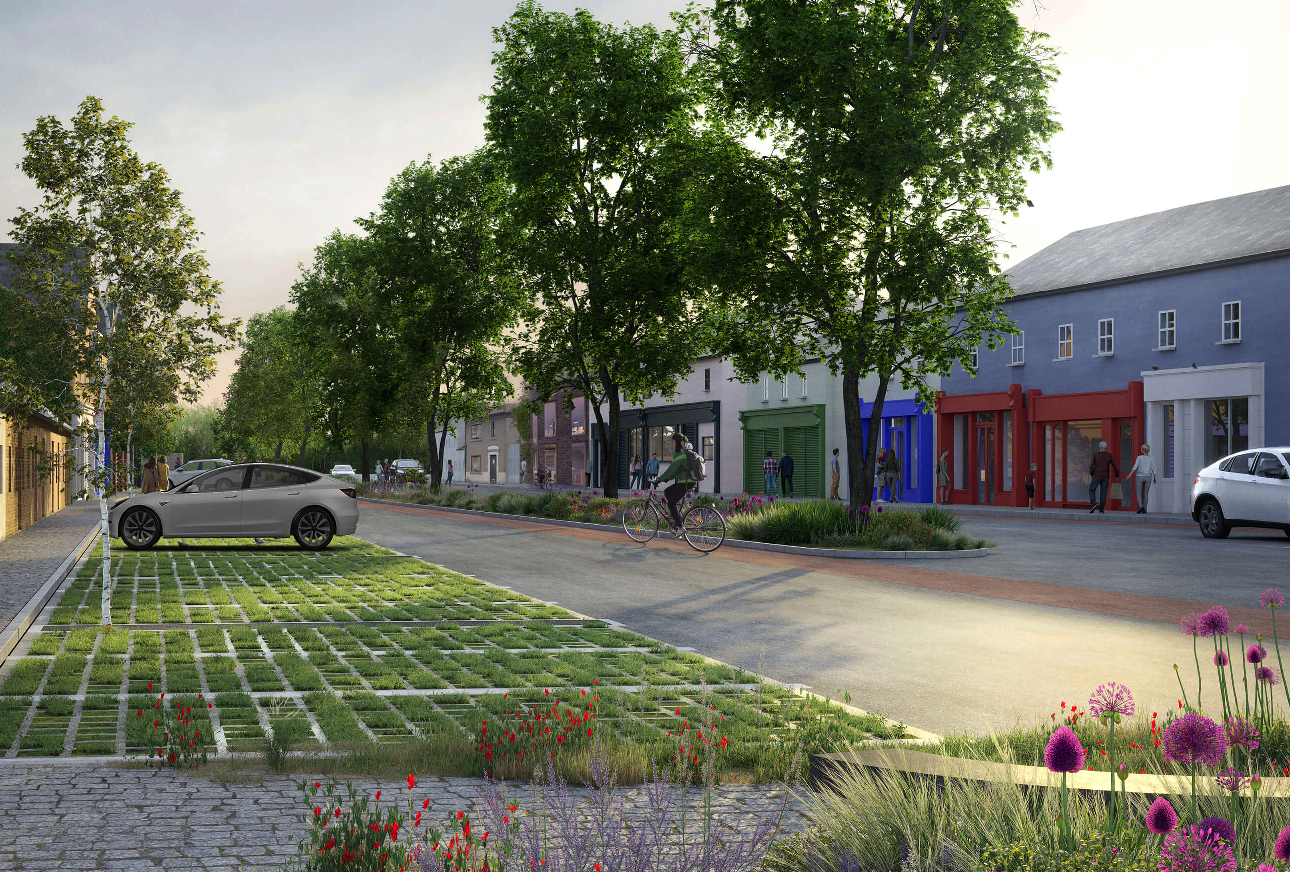
Roads in Carlow Town where a 30km/hr special speed limit presently apply include: Lower Tullow Street, Dublin Street, Brown Street, Charlotte Street, College Street, Castle Street, Potato Market and Upper Tullow Street. In order to support the delivery of a comprehensive walking and cycling network, where cycling on road alongside vehicular traffic is safe for cyclists, it is proposed to extend the 30kph limit to the following roads: Kennedy Street, Kennedy Avenue, Burrin Street up to Pembroke, Barrack Street, St. Josephs Road, Green Lane and Railway Road. This extended 30kph area includes access to main Town Centre destinations such as the railway station, the Bus Coach Park, the Carlow College, schools, the Civic Area, etc. The implementation of a wider 30km/hr zone will result in a safer, calmer and more pleasant urban environment for pedestrians, cyclists and motorists, fostering opportunities for active travel and protecting vulnerable road users.
Walking and Cycling
The creation of a comprehensive walking and cycling network will help create a resilient, low carbon transport network in the town that prioritises safe, friendly and healthy streetscapes, while reducing car dependency and improving air quality – enhancing travel choices for all and improving connectivity to employment, education, retail and leisure opportunities.
The walking strategy contains a number of new pedestrian routes within Carlow, linking residential areas to key attractions, with a focus on removing severances and improving connectivity. This strategy also includes recommendations to improve the width and condition of existing footpaths, the implementation of safe crossings that reflect pedestrian desire lines and proposals to upgrade junction arrangements to reduce delays to pedestrians. The provision of street furniture such as benches, and the delivery of the 30km/hr zone will enhance the experience, safety and comfort of pedestrians living in, studying, working and visiting Carlow Town.
Similarly, the cycling strategy has been prepared to address existing gaps and facilities in the network. This has focussed on creating a series of safe and continuous segregated cycle routes along the radial road corridors, linking residential communities to places of employment, education, recreation and the Town Centre. In addition, the plan seeks to create an ambient environment in the Town Centre favourable to cycling on street (through reduced traffic speeds and volumes).
The cycling strategy also looks to build upon Carlow’s wealth of natural assets and rich biodiversity, particularly along the River Barrow and River Burren, through the delivery of a series of green routes within the town.
Existing Walking and Cycling Facilities
Footpaths within the core of the town are generally of adequate condition and width. In certain locations, on-street parking, bollards and street furniture reduces the area available to pedestrians – leading to a sense that these streets are dominated by vehicular traffic. There is also a lack of pedestrian priority and crossing points on several key pedestrian desire lines (for example between the train station and the Town Centre).
Investment in cycling has taken place in Carlow in recent years, with the provision of cycling lanes along the N80- bypass and some of the regional roads. In the Town Centre cycle lanes have been provided along Barrack Street, Bridge Street and Hanover Road.
Cycling routes throughout Carlow are often discontinuous and there is scope for improvements to cycle lane widths, cycle parking and cycle priority at junctions. The prevalence of large roundabouts at major intersections within the town also create safety issues for cyclists.
Existing key assets in the town are the walking and cycling Barrow Way, which is a major tourist and leisure attraction, running along the towpath of the river. The River Burrin Linear Park also has a recreational route along the east of the river, which extends from Burrin Road / Hanover Road junction to The Laurels.
Walking and Cycling Strategy
A key objective of the Strategy is the development of more sustainable communities within Carlow, with an emphasis on encouraging active travel to reduce car dependency. This will be achieved through investment in active travel infrastructure and adopting consistent approaches to local area planning which prioritises development opportunities that support sustainable travel. In this regard, the Strategy recommends the following initiatives for implementation. This section can be read in conjunction with the Walking and Cycling Links maps enclosed in Appendix I.
Walking Provision
- Improve permeability in the Town Centre and Carlow College to the Train Station as described within the Intervention Areas Transport Proposals below.
- Provide accessibility connections to improve the permeability from Residential Areas, as identified within the 10 Minute Town report and maps enclosed in Appendix I.
- Enhance the walking network through additional crossings along pedestrian desire lines, e.g. Kilkenny Street, St. Joseph’s Road/Green Lane junction, Hanover Street/Burrin Street junction and Railway Road / Old Dublin Road junction.
- Increase the width of footpaths where appropriate (based on pedestrian activity levels) and feasible, in accordance with the guidance within the Design Manual for Urban Roads and Streets.
- Provide a pedestrian and cyclist footbridge to connect Carlow IT with the River Barrow Way, extending the link to the newly-developed estates along Leighlin Road (Graiguecullen) to improve recreational amenity opportunities and sustainable transport choices of residents.
Cycling Provision
- Primary network: Provide high quality cycle routes along the N80 bypass and the radial road corridors linking residential communities to places of employment, education, recreation and the Town Centre. The routes will cater for the highest levels of cycling demand and should therefore, be designed to facilitate a high Level of Service (A or B) as established in the National Transport Authority’s (NTA) ‘National Cycle Manual’.
- Secondary / Feeder Routes: Implement a secondary network of cycle routes that connects the primary network to residential areas and places of employment. Depending on the volume and speeds of traffic, secondary or feeder routes may be segregated or can share the carriageway with motorists on traffic calmed routes.
- Roundabout Improvements: Where feasible, upgrade existing roundabouts along the primary and secondary routes to cycle friendly roundabouts as per the NTA’s National Cycle Manual.
- Green Routes: Promote the existing Barrow Way and River Burrin Linear Park and take into account the outcome of the proposed Barrow Way cycle route feasibility study currently being carried out by Waterways Ireland.
- Gaps in the cycle network: to complement the existing cycle network, provide continuous cycle facilities along the main roads.
- Cycle Wayfinding: The development of a user- friendly active travel way finding signage plan, guiding cyclists to key destinations and/or attractive recreational routes, will complement the investment in the town’s cycle network, raising awareness of the network and support confidence levels for new users in their journey planning.
- Secure cycle parking: The strategy also includes provision for enhanced, secure cycle parking, which is located at strategic sites around the Town reflecting demand from key attractors. Key destinations include the rail and bus stations, schools, shopping areas and places of work.
Public Transport
Central to Carlow’s future success will be the creation of a high-quality public transport network connecting people to key destinations within the Town in a reasonable travel time. By providing residents with a choice of travel options, this will help reduce the dependency on private car travel and support healthier lifestyles. This in turn will help create a vibrant Town and strong local economy, attractive to young professionals and families.
The Public Transport Strategy includes a set of recommendations to improve accessibility for public transport in Carlow, in particular improved accessibility to Carlow Coach Park, Carlow Railway Station and Taxis.
The Public Transport Strategy also includes recommendations for the integration of Public Transport with other modes (through the development of Mobility Hub facilities at the Railway Station and Coach Park). The Strategy also supports the provision of a Carlow Town Bus Service as proposed by the National Transport Authority (NTA).
Existing and Planned Public Transport
Carlow is situated on the Dublin to Waterford rail line, with the train station located on Railway Road, approximately 1km from the Town Centre. Services from Carlow are infrequent, with an hourly frequency at peak times and gaps of up to three hours between services during the day. Improvements to frequency and timetabling would improve Carlow’s rail connectivity with the wider Eastern Region.
The train station is within a 5-10-minute walking catchment of the Town Centre; however, the majority of the town is outside of this catchment area. Adding additional pedestrian links and connections will improve the accessibility of the railway station for residents and visitors. JJ Kavanagh operate on the Dublin-Waterford route, with 13 daily services from Carlow IT and Carlow Coach Park to the Dublin Airport. Bus Eireann – Expressway routes 4 and 4X link Carlow with Dublin Airport as well. Other services to regional destinations such as Wexford, Portlaoise, Tullamore, Athlone, and Naas, are less frequent. Local Link runs a number of demand-responsive services that connect Carlow with towns and villages in its hinterland. The Carlow County Development Plan 2015 – 2021 sets out relevant policy goals for Carlow Town at a local level. It is the policy of the County to ‘Play a positive role in promoting sustainable transport to reduce levels of car dependency, and maintain an efficient and safe road and public transport network’. There are a number of actions within the Development Plan which can be utilised to support the delivery of an improved public transport network for Carlow Town, including:
- Encourage better integration of transport services in the County where possible with the aim of reducing car trips and to encourage improved consultation and co-operation between both public and private providers of transport services operating in the County and in the South East Region, including all providers of bus and rail services.
- In this regard, the Council shall be open to supporting, where practicable, initiatives to facilitate discourse and co-operation between transport service providers with a view to facilitating better integration of public transport services.
- Work with the relevant organisations to develop and maintain bus stops, waiting areas, and up to date travel information for the local population and tourists alike. The availability of such services should be promoted.
- Encourage the provision of shared bus stop facilities in appropriate locations in urban centres such as Train Stations to facilitate public and private operators, as designated in the County Settlement hierarchy.
- Work with transport providers to develop an urban public bus service for the Greater Carlow and Graiguecullen Urban Area.
The NTA in conjunction with Carlow County Council have developed two potential town routes in Carlow to connect the majority of residential areas within the town to the main employment, retail, health and education destinations. The map below shows the proposed routes and the indicative location of the bus stops. It is anticipated that the frequency will be every 30 minutes.
The proposed routes are as follows:
- CW1- Tyndall College to MSD: Connecting Tyndall College and IT College to the Town Centre via Green Road and Hanover Road before heading northwards along Barrack Street and Green Lane following the R448 up to MSD Carlow.
- CW2 – Sleaty Road to Wall’s Forge: connecting The Dome (in Graiguecullen), Carlow Town Park and Maryborough Street with the Town Centre, along Bridge Street, Castle Hill, Kennedy Avenue and Barrack Street. Then heading east along Accommodation Road, St. Patrick’s Avenue, Pollerton Road, N80 southwards and Tullow Road.
A catchment analysis for walking and cycling has been undertaken and are shown in Appendix I. The 5-10min catchment analysis for cycling shows that all proposed bus stops in Carlow are within a 10-minute cycle catchment area.
There are residential areas in Carlow that are not located within a 10-minute walking catchment to the proposed bus stops, particularly the eastern, western and southern suburbs of the town. Adding new direct pedestrian/ cyclist paths to the bus stops from the residential areas will shorten the distance, therefore it will improve the accessibility for residents living in these areas to the town bus network, thereby supporting the development of the ‘10-minute town’ concept.
The indicative location of the bus stops is shown on the figure below. Improvement works in the Town Centre, such as the Barrack Street project, should accommodate these bus stops in accordance with required standards, providing a safe and comfortable waiting area for passengers. The provision of Real Time Passenger Information for the new services will help to raise awareness among residents and visitors and build confidence in service reliability.
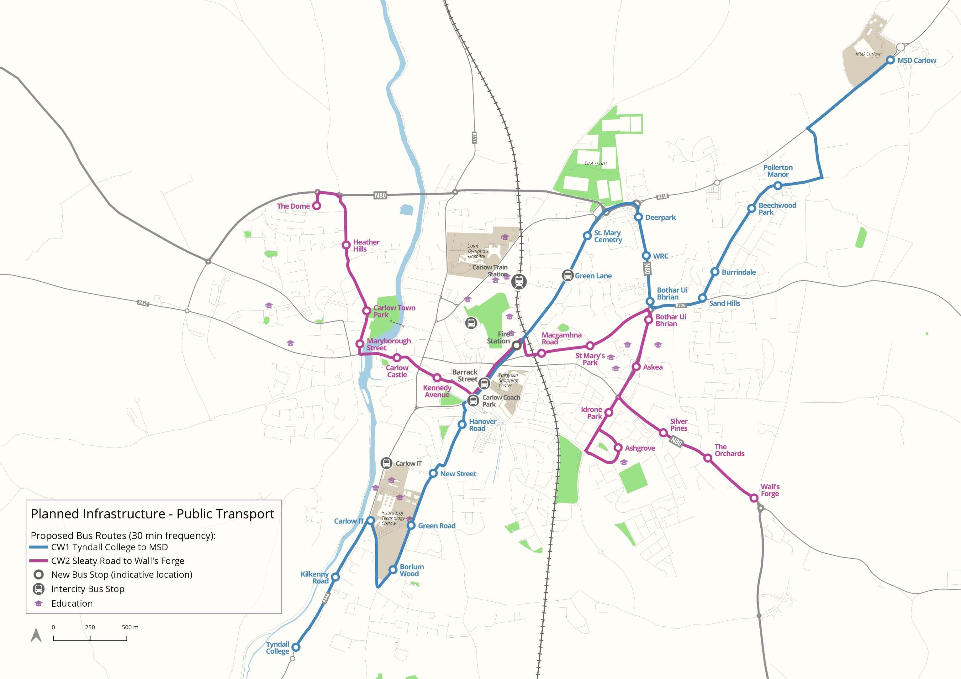
Figure 2: Planned public transport
Recommended Measures to improve accessibility to Public Transport
Recommended measures to improve accessibility to existing and proposed public transport in Carlow are as follows:
|
Location |
Opportunity to Improve Accessibility |
|---|---|
|
Railway Station |
|
|
Carlow Coach Park |
|
|
Taxis |
|
|
NTA Proposed Town Bus Service |
|
Connecting to Public Transport Links
Carlow Town will have a new bus network which will include an increased number of bus stops and improved services. This updated Cross-Town Bus Network, led alongside the National Transport Authority, will significantly improve local and regional services in the Town. The new bus service will link with the Bus Park located at the bottom of Barrack Street. The Interventions proposed to be undertaken as part of this Regeneration Strategy for Barrack Street will significantly assist in connecting the Town Centre with the public transport services along Barrack Street. The new pedestrian link form Potato Market to Barrack Street (currently being applied for under the URDF) will enable quicker and more convenient access for pedestrians to bus services, as well as connections through to the Rail Station, encouraging public transport use.
Existing and Planned Road Network
Carlow is strategically well placed on the national road network, located directly adjacent to the M9 Motorway, thereby providing excellent connectivity to Dublin (through the M7/N7) to the north, as well as Kilkenny and Waterford to the south. The M7 and M8 Motorways are approximately 40km away which provide connectivity with Limerick and Cork. The N80 National Road connects Carlow to the regional centres of Portlaoise, Enniscorthy and Wexford.
In addition, the N80 forms an orbital route around the north of Carlow, providing an additional bridge crossing over the River Barrow. The internal road network within Carlow is radial in nature, with four regional roads converging on the Town Centre. This radial network results in traffic movements through the Town Centre.
Carlow County Development Plan 2015-2021 and the Regional Spatial & Economic Strategy for the Southern Region consider the delivery of the Carlow Southern Relief Road N80-R448 a transport infrastructure priority. The completion of the Southern Relief Road and new bridging point over the River Barrow is considered important to the connectivity between the Midlands Region and South-East Region and to the local economy of the Greater Carlow Graiguecullen Urban Area. The indicative alignment of the road is illustrated in Map 1 on Appendix I.
Parking Strategy
Parking spaces are a valuable resource that needs careful management to protect the economic viability of the commercial core of the Town. A well-functioning Town Centre car parking system contributes to the local economy, helps enhance the public realm and improves accessibility for all transport modes. Parking capacity and pricing is also an effective tool that can be used to manage travel demand which helps encourage modal shift and reduces the impact of congestion on the network.
Given its large rural hinterland and the absence of high frequency public transport alternatives, there is presently a high demand for parking within Carlow Town. Whilst some areas can become oversubscribed during peak periods, there is generally a sufficient level of parking in Carlow to meet the needs of the town.
As previously noted, it is an objective of the Transport Strategy to deliver an efficient transport network that provides residents and visitors with a range of travel choices, through investment in walking, cycling and public transport infrastructure. The increase in population and employment forecast for Carlow will result in an increase in travel demand in the town, however it is the aim of the strategy that much of the future demand for travel will be met by these sustainable modes and therefore additional public parking will not be required.
Car Parking Provision & Pricing
In addition, future parking tariff rates for both short and long stay users will need to be reviewed in tandem with the fare prices for the urban bus service, to ensure the parking pricing structure does not undermine the significant investment in public transport.
Should a demand arise for additional parking, for example through the redevelopment of existing Town Centre parking sites, then this should be provided for on the periphery of the Town Centre. This will provide motorists with efficient access to parking areas without the need to traverse the Town Centre’s narrow streets.
With regard to areas benefitting from public realm enhancement plans, a reduction in on-street car parking provision is recommended in order to accommodate pedestrian/cyclist facilities and public spaces.
Adequate quantum of on-street disabled parking and parent and child parking will need to be provided (supported by enforcement to discourage inconsiderate parking), as well as set down, taxi and loading bay parking. Given government Climate Action Plan targets and current incentives to increase the take-up of electric vehicles (EV), it will also be important for the Town to provide sufficient electric vehicle charging infrastructure facilities to meet future demand. In support of this transition to low carbon transport provision, this element of the Parking Strategy will include Development Plan Parking Standards in relation to EV and the provision of on-street and off-street EV recharging facilities with an appropriate mix of rapid charging facilities. The role of EV charging facilities for the taxi fleet is also important from an Air Quality perspective within the Town.
Cycle Parking
A substantial increase in secure on-street cycle parking will also be required within the Town Centre to support
cycling trips. In addition, the role of Cycle Parking Standards (including parking, showers and changing room facilities) within the County Development Plan will play an important role in facilitating a culture of cycling through the provision of additional cycle parking provision at new developments within the town, both residential and commercial.
Car Clubs – shared mobility
Car Clubs are becoming increasingly more popular across Europe and Ireland. On average, the majority of cars in Europe are inactively parked (before or after trips are made) for approximately 16 hours a day, actively parked (during trip) for nearly 7 hours and driven less than 1 hour each day. Cars also typically cost in the region of €6,500 to own and run annually. This, combined with fact the average car requires 150m2 of urban land to park results in a considerable waste of land resources. In the past number of years, more drivers are opting to use shared car club vehicles rather than purchase their own car and there are now shared car companies in many European towns and cities.
GoCar is the largest car club company in Ireland with over 50,000 members and 700 cars and vans available nationwide, although the majority are currently within or close to Dublin. Research from other European schemes has found that each car can replace the need for up to 16 privately owned vehicles. This research also found that while 40% of users didn’t own a car prior to joining a car club, a further 22-32% gave up their car as a result of the availability of the car club.
In order to support reduced car dependency and sustainable travel, while still enabling car use for individuals when required, the provision of a Car Club facility for the Town Centre is also recommended. These shared mobility services can be provided in residential areas, within the Town Centre and at key destinations such as the Railway Station and the Colleges. Increasingly, car clubs provide hybrid or electric vehicles, which will also support the Town’s low carbon transition.
Supporting Measures – Smarter Travel
In order to lock in the benefits of the investment in active travel and public transport, a Smarter Travel behavioural change programme is recommended as part of Carlow Town’s Transport and Movement. This offers the benefits of ensuring potential users are aware of the new infrastructure, and supported and incentivised to use it – therefore maximising return on investment and encouraging more people to use sustainable, low carbon and healthy travel options.
Behavioural Change Campaigns
For example, the delivery of new cycling infrastructure can be supported by a focused promotional campaign including Town Cycle Network maps, a community based led cycle ride, cycle training, Dr Bike maintenance sessions and the promotion of local bike shops. Similarly, taster tickets could be provided for the proposed new Town Centre bus services, while new walking infrastructure could be promoted via led walks and themed heritage trail maps.
Mobility Management
Mobility Management, or travel planning, is a concept to promote sustainable transport and manage the demand for car use by changing travellers’ attitudes and behaviour. The aim of mobility management is to reduce demand for and use of private cars by increasing and promoting the attractiveness and practicality of other modes of transport. Mobility Management Plans (MMPs) in workplaces, education establishments and residential developments can have a significant impact on the travel choices of employees, students and residents. Mobility Management Plans are management tools which bring together mobility measures and actions in a co-ordinated framework allowing organisations and developments to implement measures against an agreed plan to reduce private car use.
The NTA’s Smarter Travel Workplace & Campus Programme has delivered an average reduction in car commuting of 18% where workplaces effectively engage with the Programme. Carlow Institute of Technology is a partner in the NTA scheme, and other large trip generators within the Town can be encouraged to join this programme and implement MMPs at their own sites, In the longer term, there is potential for a Town Centre MMP Forum to be established, where sites can meet, share best practice and work in partnership to promote new sustainable transport infrastructure.
The use of Residential MMPs are increasingly used now as part of Planning approvals, and could be utilised by Carlow County Council as part of Development Control to support reduced car dependency at new residential developments and support an uptake of sustainable travel options.
In Ireland, the percentage of primary schools’ students being driven to school has increased from 24% in 1986 to 59% in 2016. An Taisce’s Green Schools Programme aims to reverse this trend. As part of the Green Schools Travel Theme, schools create an Action Plan with travel targets. The aim of the plan is to increase the number of students using sustainable modes and to reduce use of the private car. They Action Plans emphasise, the health and fitness benefits of sustainable travel for children as well as the external benefits of decreased car use in improved air quality and reduced GHG emissions. As with workplace MMPs, more local schools in Carlow Town can be encouraged to join the Green Schools Programme and support healthy, low carbon travel options for pupils, parents and staff.
Upgraded Barrack Street
Intervention Areas – Transport Proposals
The Carlow Town RVIS focuses on six Intervention Areas (as shown on the series of maps in Section 6 Urban Design and Implementation), containing Public Realm projects and development opportunities in and around Carlow Town Centre. The Intervention Areas consist of: Town Centre, Cultural Quarter, The Barrack Track/Civic Spine, The Pembroke District, The Burren Riverfront and Link Streets (e.g. Dublin Street and Tullow Street).
This section identifies the proposed transport interventions required to support the development of the Intervention Areas, including junction improvements, road realignment, traffic management, walking and cycling links, and public realm enhancement works as outlined below.
Town Centre – Potato Market and Barrack Street
- Upgrade the existing roundabout junction at Potato Market / Kennedy Avenue to a traffic signalised junction, including the access to the southern car park. This will facilitate the safe passage of pedestrians and cyclist at this location, whilst maintaining vehicular movements.
- The creation of a pedestrian only link from Barrack Street to Potato Market as part of a high-quality public realm scheme.
- Improved access to public transport services including new proposed bus services on Barrack Street and Carlow Train Station.
- Realignment of access to the Carlow Shopping Centre Car Park from Kennedy Avenue East. This access will serve the existing car park spaces at the rear of AIB Bank and also used for delivery services. It is proposed that delivery vehicles using this route will be managed and limited to early morning hours to avoid conflicts with pedestrian and cyclists along the proposed link.
- The existing service yard within the Shopping Centre will be accessible from Tullow Street and Barrack Street, as indicated in the figure below.
- Access to Exchequer House car park will be provided from Potato Market, with the inclusion of bollards recommended alongside this access point in order to delineate the vehicular route and safeguard vulnerable road users.
- Repositioning of the taxi rank on Kennedy Avenue to gain additional public space and enable the provision of cycle lanes on Kennedy Avenue.
- Barrack Street improvements including the upgrade of the Shamrock Square junction to a cycle friendly junction (including the provision of continuous cycle lanes, advance stacking space for cyclist and pedestrian crossings on all arms of the junction). The approach to the junction from Tullow Street will be narrowed to increase the footpath width and provide a new crossing, improving the pedestrian experience.
- Upgrade of the roundabout junction at Barrack Street / Kennedy Avenue to a traffic signalised junction in order to provide improved cycle facilities (in accordance with the NTA’s National Cycle Manual) and improve the pedestrian facilities by increasing the footpaths width and facilitating controlled pedestrian crossings on all arms. This junction will be a 4-arm junction including vehicular access to the Carlow Coach Park.
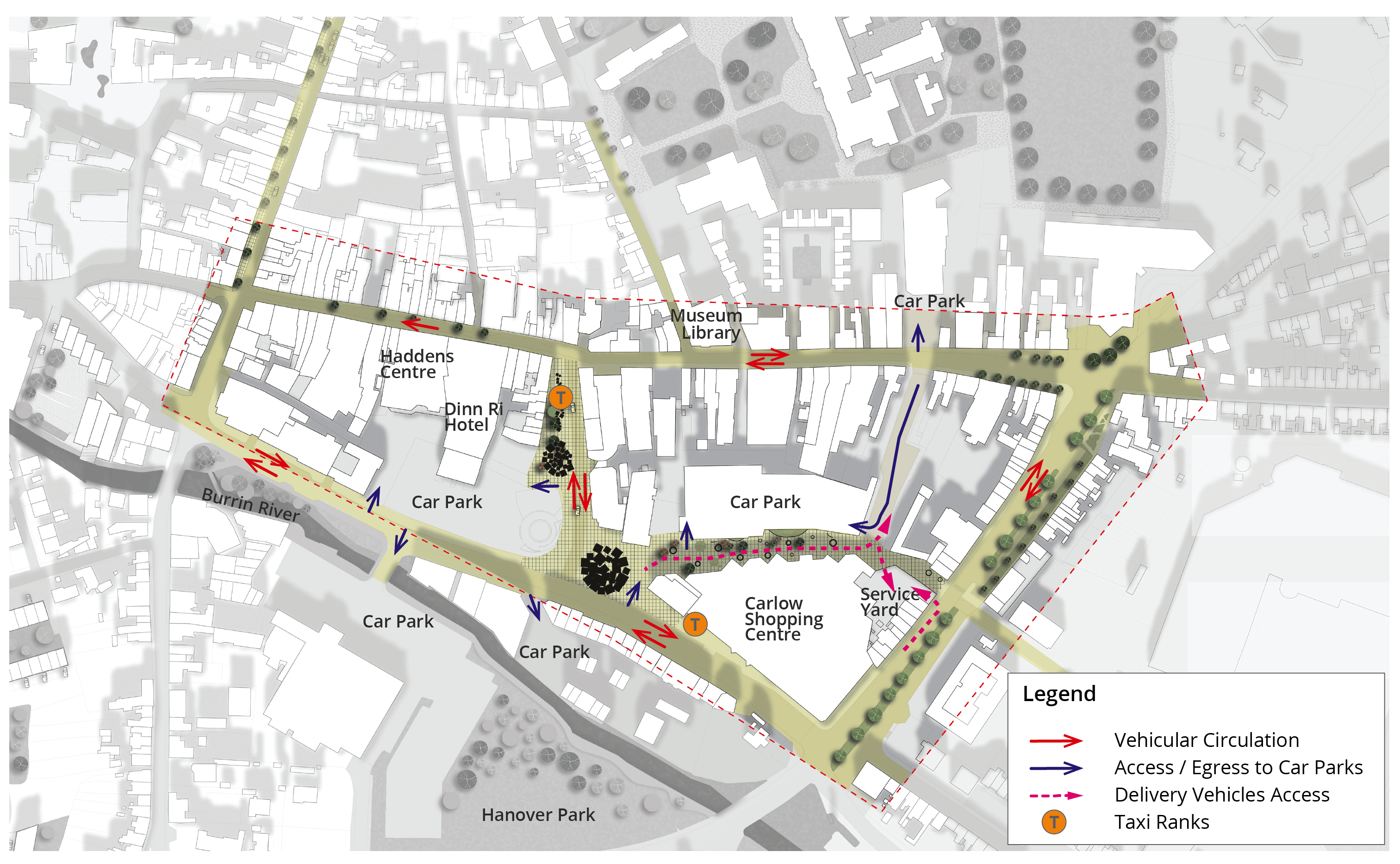
Figure 3: Carlow Town Centre Circulation
Cultural Quarter
- Provision of a new key link from Carlow College to the Railway Station, “Railway Link”, to facilitate user connectivity between Railway Station and Carlow College. This link will be complemented by a formal pedestrian crossing in St. Josephs Road.
- Upgrade College Street Upper to improve the existing footpaths and provide formal pedestrian crossings along desire lines.
- Provide new pedestrian and cyclist links from Green Lane via the Plaza Public Car Park, and a pedestrian and cyclist link from Tullow Street via the existing Car Park.
The Barrack Track / Civic Spine
- Provision of promenade access to the proposed Hotel and Mixed-Use Development on this site from Andy Murphy Road.
- The proposed Civic Spine serving the site will be a shared pedestrian and vehicular route.
- Additional pedestrian and cyclist accessibility provided from Cox Lane and Barrow Track.
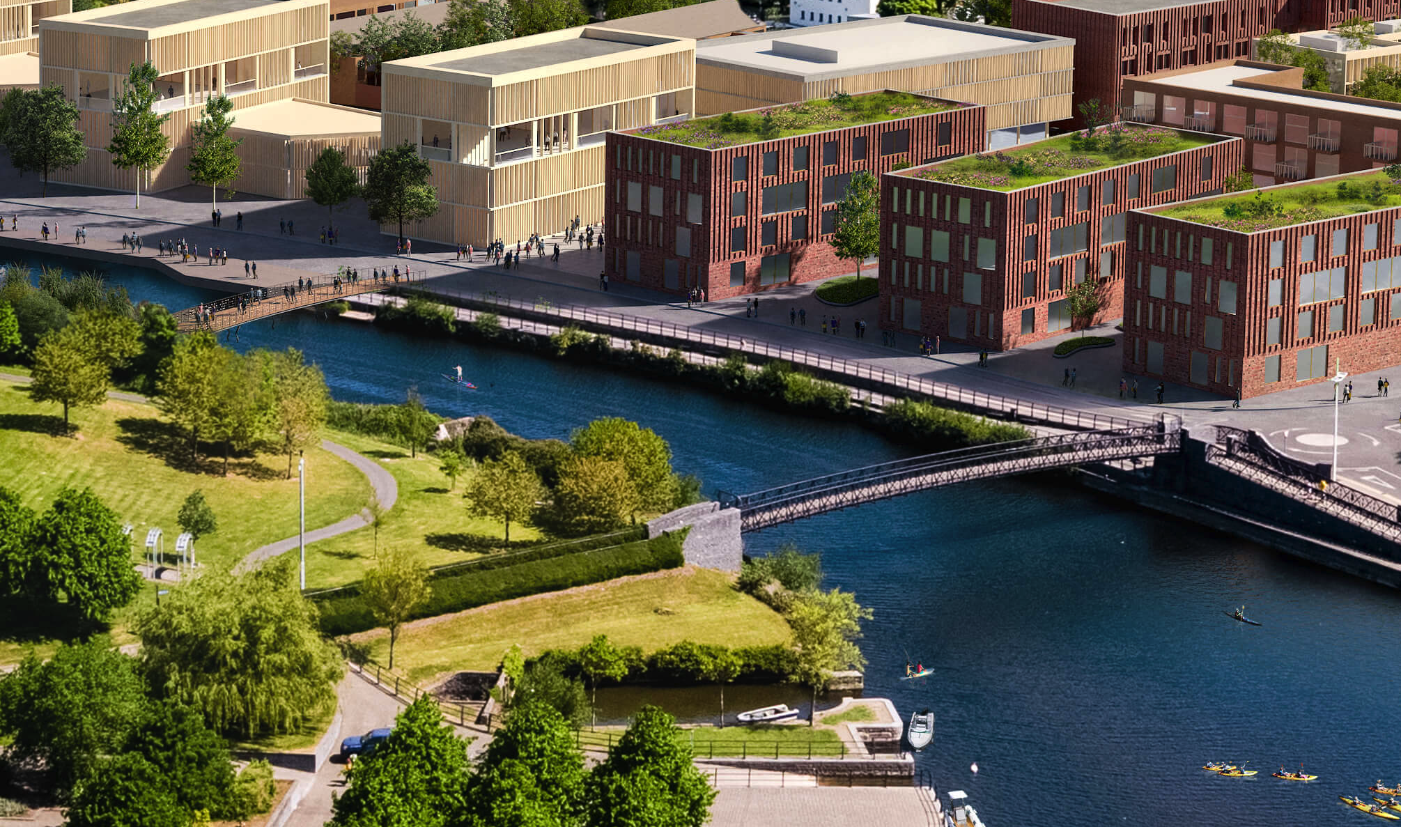
- Provision of a n new footbridge over the River Barrow to connect the area with Carlow Town Park.
The Pembroke District
- It is proposed to provide a vehicular access from Castle Hill along the continuation of Governey Square with the provision of a road bridge over the River Burrin. This bridge should include footpaths to facilitate pedestrian connections and accessibility.
- Provision of a pedestrian/cyclist bridge to link the Riverfront connection.
- Implementation of remedial works (in the form of kerb realignment) at the existing Pembroke / Burrin Street Junction, in order to improve the visibility at the junction and enhance pedestrian facilities.
The Burren Riverfront
- Provision of a walkway along the River Burrin from Burrin Street up to the Castle. This link will connect to the pedestrian link along the River Barrow.
- On the eastern side of Burrin Street, it is proposed that this link continues along the riverbank walk up to Hanover Park, thereby creating an attractive east-west link for pedestrians and cyclists.
Link Streets (e.g. Dublin Street and Tullow Street)
- Dublin Street is a key spine connecting north and south of the town. Improved pedestrian facilities on this street are recommended, while maintaining 2-way traffic. This can be achieved by narrowing the carriageway and widening the footpaths where feasible, along with the creation of additional pedestrian crossing opportunities and enhancements to street furniture and seating.
- Dublin Street is an important link for cyclists. While the carriageway width doesn’t allow to provide cycle lanes, the 30kph zone and the proposed public realm works will create a low traffic environment for cyclists sharing the road with vehicular traffic.
- Upgraded pavement solutions provided along Tullow Street (with seating) and extended up to Shamrock Square to enhance the pedestrian experience.
Upgraded Potato Market
Pedestrian and Cyclist Links at Barrow Track
Outcomes and Actions
A set of Outcomes have been derived and formulated in relation to the Transport and Movement Core Theme. An associated Action accompanies each that provides a clear direction for the delivery of the Outcome.
|
1 |
Support the development of more sustainable communities within Carlow, with an emphasis on encouraging active travel and low carbon shared mobility. |
|---|---|
|
|
|
|
|
* The creation of a comprehensive walking and cycling network. |
|
* Enhancements to public transport |
|
|
* Meeting the rapidly changing travel needs of society in a sustainable manner. |
|
|
* Contribute to Carlow’s transition to a low carbon economy. |
|
|
* Mobility Management to support smarter travel choices. |
|
|
* Parking strategy to support a low carbon safe and vibrant Town Centre. |
|
2 |
Provide a number of new pedestrian routes within Carlow Town through each of the 6 Intervention Areas, linking residential areas to key attractions, with a focus on removing barriers to movement and improving connectivity. |
|---|---|
|
|
|
|
|
* Increase in pedestrian-friendly activity. |
|
* Improved pedestrian safety. |
|
|
* Promotion of and support for active modes of travel. |
|
|
* Support enhanced retail activity in the Town Centre. |
|
3 |
Deliver a high-quality public transport network that is highly accessible on foot or by bicycle and that connects people to key destinations within the Town in a reasonable travel time. |
|---|---|
|
|
|
|
|
* Provide residents with a choice of travel options. |
| * Help reduce the dependency on private car travel and support healthier lifestyles. | |
| * Improve multi-modal transport options and interchange opportunities. | |
| * Create a vibrant Town and strong local economy, attractive to young professionals and families. | |
| * Quality public transport offering enhances attractiveness of 3rd level institutions, supporting student recruitment and retention. | |
| * Facilitate improved pedestrian and cycle links to Carlow Bus Park and Carlow Train Station. | |
| * Quality public transport offering improves access and transport choices for tourists. |
|
4 |
Implement the cycling strategy that has been prepared to address existing gaps in the network and focuses on creating a series of safe and continuous segregated cycle routes along the radial road corridors, linking residential communities to places of employment, education, recreation and the Town Centre. |
|---|---|
|
|
|
|
|
* Provide residents with a choice of travel options. |
| * Help reduce the dependency on private car travel and support healthier lifestyles. | |
| * Improve multi-modal transport options and interchange opportunities. | |
| * Create a vibrant Town and strong local economy, attractive to young professionals and families. | |
| * Quality public transport offering enhances attractiveness of 3rd level institutions, supporting student recruitment and retention. | |
| * Quality public transport offering improves access and transport choices for tourists. |
|
5 |
Build upon Carlow’s wealth of natural assets and rich biodiversity, particularly along the River Barrow and River Burren, through the delivery of a series of green routes within the Town. |
|---|---|
|
|
|
|
|
* Creation of usable public spaces. |
|
* Provision of new pedestrian/cyclist routes to key locations in the Town Centre. |
|
|
* Supports biodiversity initiatives in the Town Centre. |
|
|
* Creation of a quality public realm that improves the attractiveness of Carlow for tourists. |