The conservation of the flora and fauna along the banks of the barrow is extremely important as has previously been ruled. Also the objections to a blue way have already been strongly...
Chapter 9: Landscape and Green Infrastructure
Dúnta21 Iúil, 2021, 09:00 - 1 D.F., 2021, 17:00
Aim: To protect, conserve and enhance the character, quality, and value of the County’s landscape, in conjunction with recognition and support for the role of green infrastructure as a natural resource in the landscape, capable of delivering a wide range of environmental and quality of life benefits, including climate change adaptation.
9.0 Introduction
Despite being the second smallest county in Ireland, Carlow contains significant areas of landscape importance, ranging from mountains, hills, rolling farmland, river valleys, and woodlands. These areas not only have an intrinsic value as places of natural and scenic beauty, but also as a real asset for residents and visitors alike, affording quality of life and economic benefits, with opportunities for outdoor recreation, tourism, and other uses. The County’s landscape is a significant part of peoples’ lives, contributing to a sense of place and identity, and is the backdrop to which all change takes place.
The interconnected network of land and water contained within the landscape of the County, including (inter alia) its open spaces, farmland, rivers, woodlands, wetlands, wildlife habitats and protected areas, can also be considered as a form of infrastructure, which can provide natural solutions for the achievement of economic, social, educational and ecological benefits. This infrastructure is a vital component in understanding the advantages that the landscape and natural environment of the County can offer, including the protection of biodiversity, drainage/flood management, far reaching benefits such as reducing the effects of climate change.
9.1 Policy Context
The key legislative and policy context for landscape and green infrastructure that informed this chapter of the Plan includes (inter alia):
- National Landscape Strategy for Ireland 2015-2025, Department of Arts, Heritage and the Gaeltacht
- Draft Landscape and Landscape Assessment Guidelines for Planning Authorities 2000, Department of the Environment and Local Government
- Planning and Development Act 2000 (as amended)
- Historic Landscape Characterisation in Ireland, Best Practice Guidance, The Heritage Council 2013
- Guidelines for Landscape and Visual Impact Assessment, Third Edition, UK, Routledge Landscape Institute, LI, and Institute of Environmental Management and Assessment, IEMA, (2013).
- EU Biodiversity Strategy for 2030
- Building a Green Infrastructure for Europe, European Commission, 2013
- Creating Green Infrastructure for Ireland, Enhancing Natural Capital for Human Wellbeing, Comhar Sustainable Development Council, 2010
- Integrating Ecosystem Approaches, Green Infrastructure and Spatial Planning, EPA, 2012
- National Biodiversity Action Plan 2017-2021
- Green Infrastructure: A ‘How To’ Guide for Disseminating and Integrating the Concept into Spatial Planning Practice, Report No. 182, EPA, 2016.
9.2 Landscape
In 2000 the Department of the Environment Heritage and Local Government published ‘Draft Landscape and Landscape Assessment Guidelines for Planning Authorities’. The Guidelines aimed “to heighten awareness of the importance of landscape in all aspects of physical planning, to provide guidance to planners and to others as to how landscape considerations should be dealt with and to indicate specific requirements for Development Plans and for development control”.
Ireland subsequently signed and ratified the Council of Europe’s European Landscape Convention (ELC) in 2002, also known as the Florence Convention. The ELC came into force in 2004 and promotes the protection, management and planning of European landscapes, and organises European co-operation on landscape issues. For the ELC landscape means “an area, as perceived by people, whose character is the result of the action and interaction of natural and/or human factor”.
In 2013, the Heritage Council, in recognition of landscape as a cornerstone of our history and heritage, published ‘Best Practice Guidance for Historic Landscape Characterisation in Ireland’. The purpose of the guidance is to inform the development of landscape policy in terms of identifying the contribution of the past to the landscape, and therefore it’s historical value as a social resource and record of human history. The importance of history and of heritage is reflected in the definition of landscape in the Heritage Act 1995, which states that it includes “areas, sites, vistas and features of significant scenic, archaeological, geological, historical, ecological or other scientific interest”.
A National Landscape Strategy for Ireland 2015-2025 was published by the Department of Arts, Heritage and the Gaeltacht. A key function of the Strategy has been to ensure compliance with the ELC, and to establish principles for protecting and enhancing landscape while positively managing its change.
The importance of landscape and visual amenity at a national level, and the role of planning in its protection, is also recognised in the Planning and Development Act 2000 (as amended). The ELC definition of landscape has been included in the Planning and Development Act 2000 (as amended). The Act requires that development plans contain particular objectives relating to landscape, including ‘relevant policies or objectives…relating to providing a framework for identification, assessment, protection, management and planning of landscapes having regard to the European Landscape Convention’.
9.3 Landscape Character Assessment
An important tool for understanding and articulating the character of a landscape is Landscape Character Assessment (LCA). LCA assists in identifying features in both urban and rural environments that give localities a sense of place, and in pinpointing what makes them different from neighbouring areas so as to appropriately guide and manage change. The existing LCA for the County, which was included with the previous County Development Plan, has been carried through to this Plan (See Appendix VII), but with some minor amendments made to its format and layout for ease of reference. The LCA is an important resource for the Council, and an extremely useful tool that should be used by agents/applicants when preparing planning applications. It gives guidance and advice on key characteristics of the County’s landscape and how sensitive it is to change, addressing issues such as land cover, topography, geology, soils, settlements, and historical landscapes.
9.4 County Landscape Character Areas and Landscape Types
The Landscape Character Assessment for Carlow groups and maps the landscapes of the County into four major Landscape Character Areas, and includes detailed recommendations for their management, protection and conservation. The Landscape Character Areas include:
- Blackstairs and Mount Leinster Uplands
- Central Lowlands
- River Slaney/East Rolling Farmland
- Killeshin Hills
The Landscape Character Areas were subject to a more detailed analysis to give recognition to specific landscape features. It is these specific features that often contain more significant and sensitive landscapes that are highly valued for scenery and amenity. Identified as Landscape Types, these features, numbering seven in total, include:
- Broad River Valley
- Narrow River Valley
- Built Up Areas
- Farmed Lowland
- Farmed Ridges
- Rolling Rough Grazing
- Uplands
The four Landscape Character Areas, including the Landscape Types they contain, are shown on Map 9.1 and 9.2. The LCAs are summarised as follows:
Blackstairs and Mount Leinster Uplands
The Mount Leinster/ Blackstairs Landscape Character Area is situated on the eastern side of the County along the border with County Wexford. It is dominated by the uplands of the Blackstairs Mountains and Mount Leinster, which extend as a distinct ridgeline for c. 25km northwards from the border with Wexford. Mount Leinster is largely located in Wexford; however, the western slopes are in County Carlow. The slopes of the mountain descend westwards on to an undulating landscape, which converges with the landscape of the Central Lowlands landscape character area.
In terms of natural attributes and scenery, this character area is the most important in the County and is as such highly sensitive to change. This particularly applies to the uplands/mountains whereas the farmed ridges and rolling rough grazing types would be moderately sensitive.
The Blackstairs and Mount Leinster Uplands contains the following Landscape Types: uplands/mountains, rolling rough grazing, farmed ridges, narrow river valley.
Central Lowlands
The central lowlands landscape character area occupies a substantial portion of the County and includes the County’s major settlements. The landscape is primarily rural, with medium to quite large fields defined by well maintained and generally low hedges and occasional to frequent hedgerow trees. Since the 1950s, field enlargement has been taken place to accommodate larger farm machinery and has involved the removal of hedges and trees. A dense network of local roads traverses the area, as well as the M9 and the N80.
The Central lowlands has capacity to absorb most types of development subject to the implementation of appropriate mitigation measures. The area encompasses river valleys and ridges that are, however, more sensitive to development than other locations within the area. These include the Barrow, Slaney and Douglas River Valleys.
The Central Lowlands contain the following Landscape Types: broad and narrow river valleys, farmed lowlands and farmed ridges.
River Slaney – East Rolling Farmland
The Slaney - East Rolling Farmland Character Area is located in the northeast corner of the County to the east of the River Slaney Valley.
While there is no definite demarcation line between the central plain and the River Slaney character area, there is a gradual alteration in landscape character. The lands ascend to a somewhat higher altitude on the approach to Hacketstown and on to the border with County Wicklow to the north and east, and County Wexford to the south. These lands are in a 150-260m OD elevation band. The presence of the Wicklow Mountains is a dominating backdrop to the area with quite high mountains to the immediate east.
Much of the landscape character is relatively intact and is representative of a well-managed agricultural landscape. There is potential for the disturbance of landscape character through the construction of inappropriately sited and designed one-off housing in the countryside and through inappropriate or poorly planned suburban expansion in the vicinity of Hacketstown and the villages in the area.
The River Slaney – East Rolling Farmland contains the following Landscape Types: rolling rough grazing, farmed ridges, farmed lowland, and narrow river valleys.
Killeshin Hills
This character area lies on the western side of the County on the border with Counties Kilkenny and Laois and a short segment of County Kildare. The area is bounded to the east by the river Barrow Valley with the R448 skirting along the east side of the valley. The lands adjoining the river valley are gently undulating hills which ascend steeply to uplands adjoining County Kilkenny: the Castlecomer Plateau. There are extensive panoramic views of the entire County to be had from the eastern slopes.
The area is almost entirely a rural agricultural landscape with a moderate level of sensitivity and moderate potential capacity to absorb different types of development. Due to its upland character and relative exposure, it has a low potential capacity to absorb rural housing or industrial development.
The Killeshin Hills contains the following Landscape Types: uplands, farmed ridges, farmed lowlands and broad river valley.
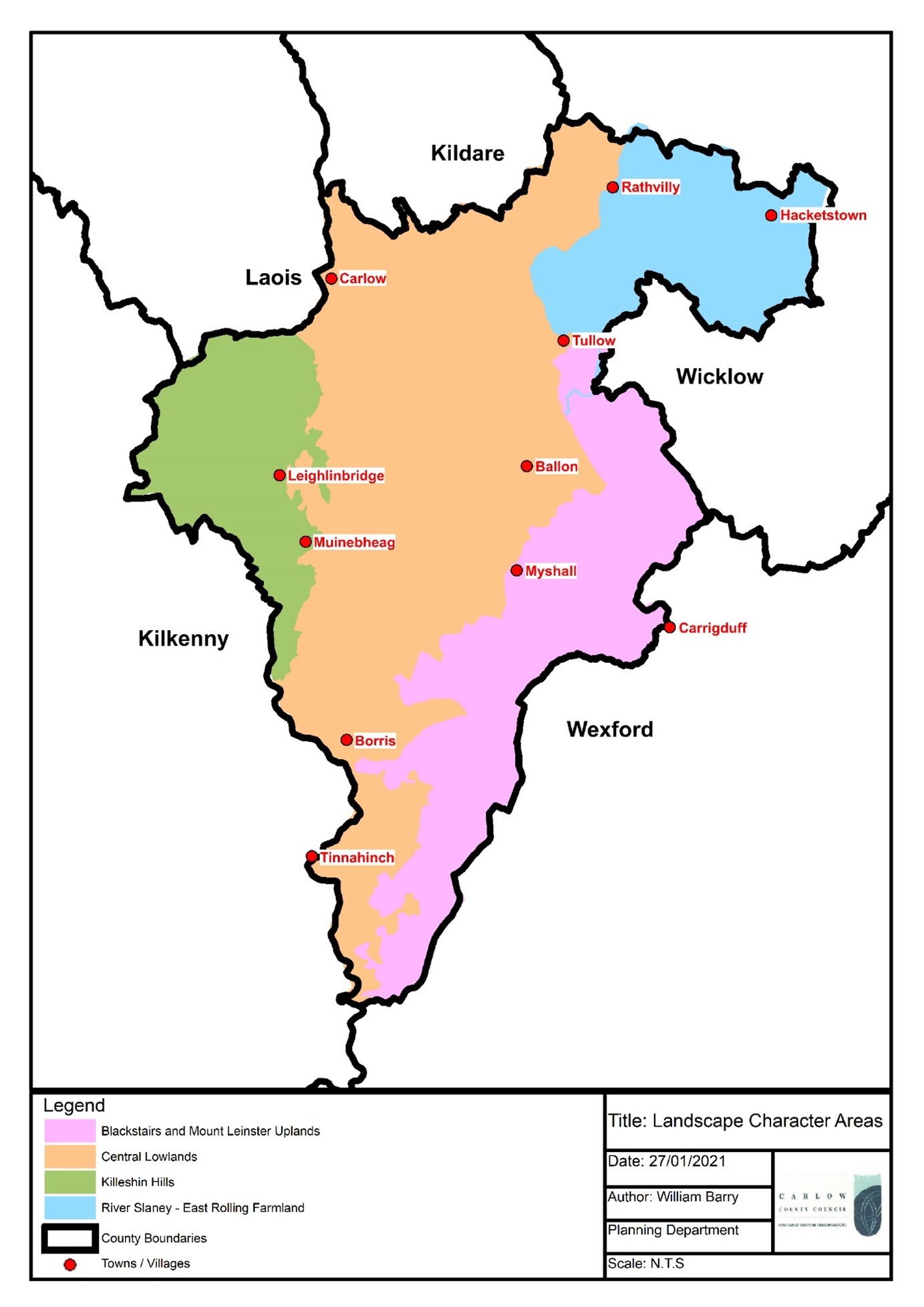 Map 9.1 Landscape Character Areas
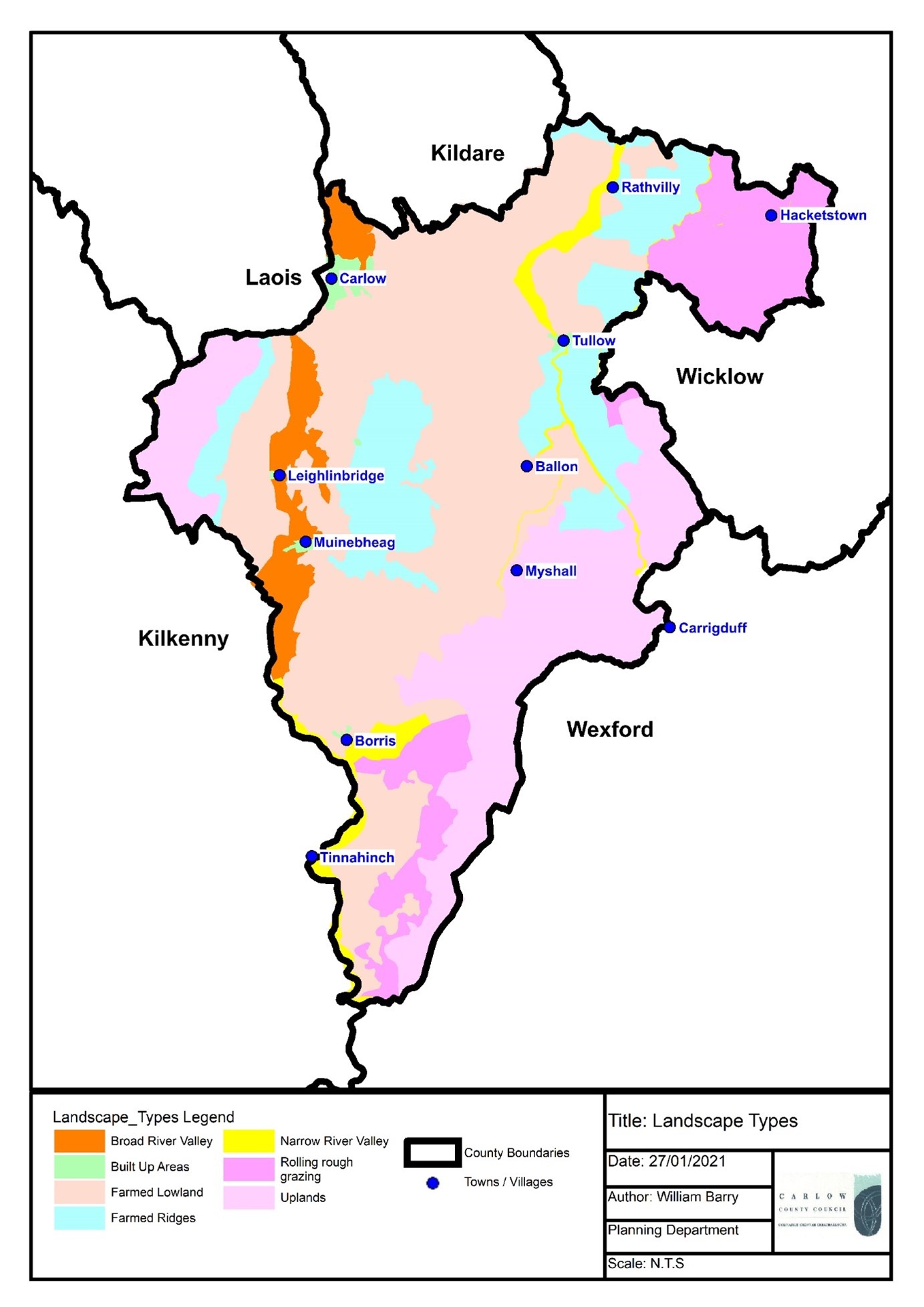 Map 9.2 Landscape Types
9.5 County Landscape Sensitivity and Capacity
To ensure that there is a comprehensive and easily understood framework to guide development in the landscape, a landscape sensitivity map and sensitivity rating was prepared for the County Landscape Character Assessment. Landscape sensitivity is a way of measuring the ability of the landscape to accommodate change or intervention without suffering unacceptable loss of character or value. The landscape sensitivity map and rating system for the County was informed by the Landscape Character Areas, Landscape Types, and the views, prospects and scenic routes discussed in Section 9.7. Landscape sensitivity is rated from 1 to 5, with 1 being least sensitive and 5 being most sensitive.
In a broad sense, in instances where a wide range of developments would sit comfortably in a particular landscape and not interfere with a character or interfere with or eliminate a value, such a landscape can be deemed to be of low sensitivity. On the other hand, where any development proposal would seriously damage a character or eliminate or seriously damage an irreplaceable value, such a landscape would be considered to be highly sensitive.
In County Carlow, as evident from the Landscape Sensitivity Map (Map 9.3) and Table 9.1, areas that may be less sensitive to change correspond to the built-up areas and farmed lowlands, while areas that may be most sensitive to change are uplands, river valleys and farmed ridges.
In addition to landscape sensitivity mapping and ratings, the County LCA also incorporates a land use capacity matrix. The matrix, included in this Chapter as Table 9.2, provides a breakdown of the capacity of the four main Landscape Character Areas to accommodate different land uses e.g. rural housing, wind farms, agriculture, urban development etc.
The capacity of the County’s landscape to visually absorb certain land uses, development, or physical change, without affecting its visual character or quality, can be influenced by one (or a combination) of the following three factors:
- Topography: development that is in elevated, exposed or upland areas will usually be visible over a wide area, whereas development in more low lying and enclosed areas usually will not.
- Vegetation: there is greater opportunity for development to be screened from view in areas which support (or have the potential to support) woodland, trees or tall hedges.
- Development: New development is less likely to be conspicuous in the context of existing development/built up areas in the landscape.
In assessing visual impacts on the landscape consideration must also be given to the nature or type of impacts. Potential visual impacts on the landscape can:
- be individual, or cumulative with existing or planned developments.
- result in a gradual erosion of the landscape value of an area, individually, or cumulatively over time.
- be due to where a development is sited in the landscape.
- arise because of the scale or design of a development.
- be because a development is incongruous or alien to its landscape setting.
- be significant for a small area (or local landscape setting) or for a larger more extensive area.
In order to minimise visual impacts from development proposals, the selection of appropriate sites within the landscape in the first instance is critical, together with careful consideration of details of layout, design, height, scale, bulk, use of materials etc. There will be a presumption against development proposals located on elevated and visually exposed sites.
9.6 Landscape and Visual Impact Assessment
The evaluation of potential landscape and visual impacts from development proposals is a key component of the Council’s assessment of planning applications. Landscape and Visual Impact Assessment (LVIA) is a tool that can assist in identifying and assessing the significance of, and the effects of, change from development on the landscape, and on people’s views and visual amenity.
LVIA should be carried out for significant development proposals e.g. wind turbine or solar array developments, quarries, telecommunications infrastructure, etc. However, there may also be a requirement, determined on a case-by-case basis, to carry out LVIA for smaller developments, taking account of the landscape sensitivity of an area and/or concerns regarding potential negative landscape or visual impacts. The level of detail that would be proportionate in an LVIA, by reason of the significance, scale or complexity of potential impacts from a development proposal, can be agreed through pre-planning discussions.
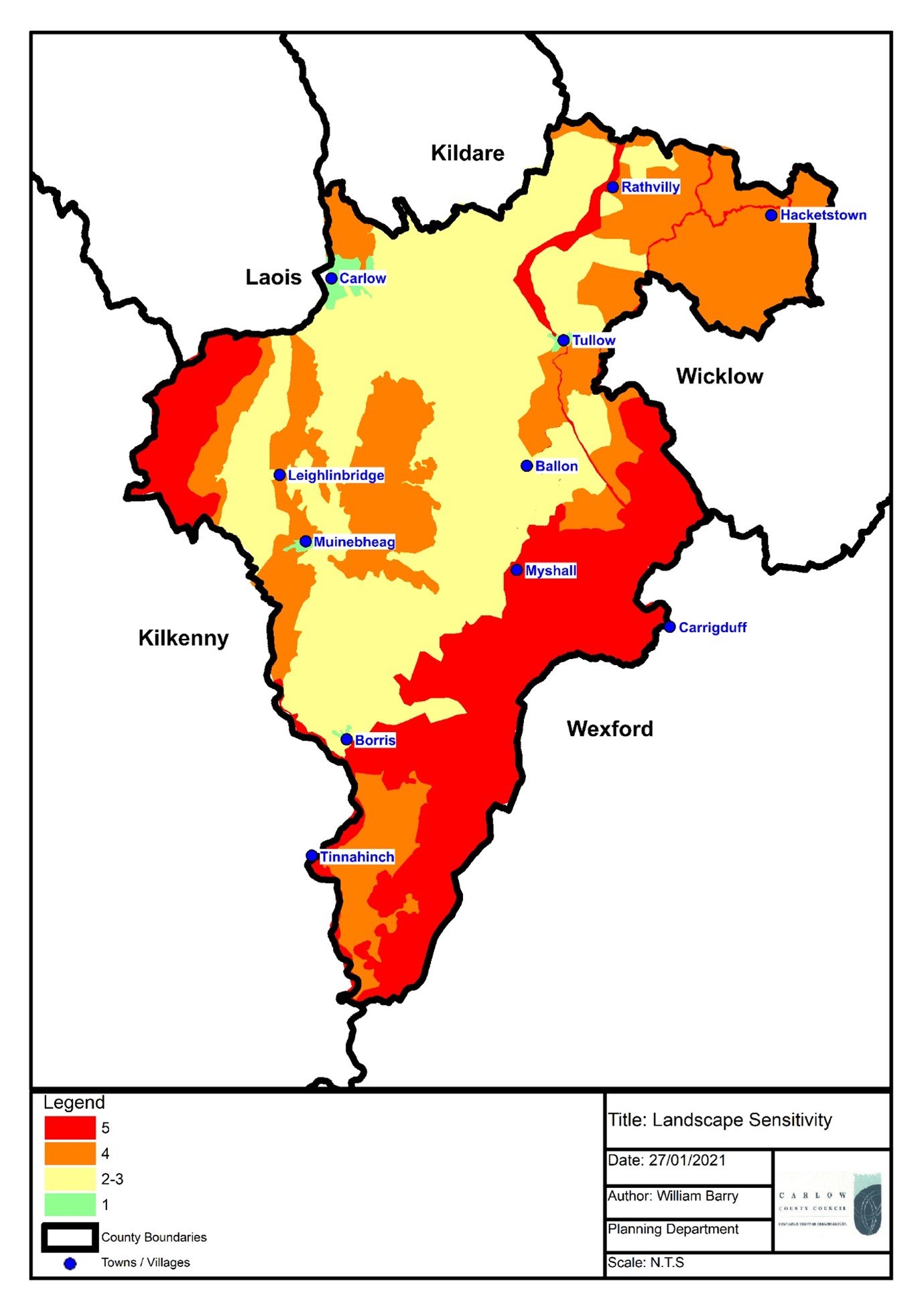 Map 9.3 Landscape Sensitivity
|
|
SENSITIVITY |
||||
|
|
1 |
2 |
3 |
4 |
5 |
|
|
Least |
Decreasing |
Moderate |
Increasing |
Most |
|
Built up areas |
|
|
|
|
|
|
Farmed Lowland |
|
|
|
* |
|
|
Broad River Valley |
|
|
|
|
|
|
Farmed Ridges |
|
|
|
|
|
|
Narrow River Valley |
|
|
|
|
|
|
Rolling Rough Grazing |
|
|
|
|
|
|
Uplands |
|
|
|
|
|
Table 9.1: Landscape Sensitivity
|
Land Use type |
Mount Leinster - Blackstairs |
Central lowlands |
River Slaney - East Rolling Farmland |
Killeshin Hills |
|
Agriculture |
Low |
High |
High |
High |
|
Rural housing |
Low |
Moderate |
Low |
Low |
|
Urban development/expansion |
Low |
Moderate |
Moderate |
Low |
|
Forestry Plantation |
Moderate |
Moderate |
Moderate |
Moderate |
|
Tourism related activity* |
High |
High |
High |
High |
|
Industrial development |
Low |
Low |
Low |
Low |
|
Extractive industry |
Low |
Moderate |
Moderate |
Moderate |
|
Wind farming |
Low |
Moderate |
Moderate |
Moderate |
Table 9.2: Land Use Capacity Matrix
9.7 Views, Prospects and Scenic Routes
County Carlow has a number of valuable views, prospects and scenic routes, many of which offer vistas with extensive views across the County. The Landscape Character Assessment of the County lists and maps the views, prospects and scenic routes which merit protection because of their inherent quality, including scenic and aesthetic attributes. These include views to and from upland areas, views of heritage features, and views along river corridors. (See Table 9.3 and Table 9.4). Maps 9.4 and 9.5 included in this chapter provide further clarity to those included in the Landscape Character Assessment (See Appendix VII), by collating and consolidating all views, prospects and scenic routes into two separate maps.
The identification of these views, prospects and scenic routes provides a tool for making development decisions that acknowledges the importance of protecting such assets and thus maintaining the overall integrity of the County’s landscape. However, it is also acknowledged that in certain circumstances some development may be necessary, and in such cases appropriate location, siting and design criteria should strictly apply.
Table 9.3 Schedule of Views and Prospects |
|||||
|
No. |
Description |
Location |
|||
|
1 |
View southwest, of valley of River Slaney, Route of South Leinster Way |
Kildavin |
|||
|
2 |
View south, of Derry River |
Clonegall Bridge |
|||
|
3 |
Vista south, of typical rolling farmland |
Knocknatubbrid |
|||
|
4 |
Vista east, of typical rolling farmland |
South of Tullow |
|||
|
5 |
Vista 260-320º, panoramic view of Killeshin Hills |
Killerrig Cross |
|||
|
6 |
Vista 80-140º, panorama across Central Plain to Blackstairs |
Kill Cross |
|||
|
7 |
Vista east, of River Slaney-East Rolling Farmlands |
Lisnevagh |
|||
|
8 |
Vista east, of rolling farmlands and distant hills |
Lisnevagh Gardens |
|||
|
9 |
Vista southeast |
North side of Constable Hill |
|||
|
10 |
View south, of Constable and Eagle Hills |
Sualsford Bridge |
|||
|
11 |
View east, of Eagle Hill |
Eagle Hill |
|||
|
12 |
Vista 170-260º, panorama of River Slaney-East Rolling Hills and Blackstairs |
Between Constable/Eagle Hills |
|||
|
13 |
Vista east, panoramic view towards Wicklow Hills |
Minvaud East |
|||
|
14 |
View north, of Eagle and Constable Hills |
West of Clonmore at Blackhill |
|||
|
15 |
Vista southeast, of south end of River Slaney-East Rolling landscape/Blackstairs |
West of Clonmore at Blackhill |
|||
|
16 |
View east, of Eagle Hill |
On Constable Hill |
|||
|
17 |
Vista 180-300º, of south end of River Slaney-East Rolling landscape/Blackstairs |
On Constable Hill |
|||
|
18 |
Vista south, Panorama over Hacketstown with Constable, Eagle and Wicklow Hills |
Porchavodda |
|||
|
19 |
View southeast, of heritage site |
Duckett’s Grove |
|||
|
20 |
Vista northeast, of spreading central plain and forest in distance |
Duckett’s Grove |
|||
|
21 |
View on approach from west, of heritage site |
Duckett’s Grove |
|||
|
22 |
Vista 90-140º, of central plain and avenue to Duckett’s Grove |
Palatine |
|||
|
23 |
Vista 280-320º, panorama over central plain to Killeshin Hills |
Palatine |
|||
|
24 |
Vista 280-320º, of Burren River Valley |
Moyle |
|||
|
25 |
View southeast, of tree ridge and church |
Kellistown East |
|||
|
26 |
Vista southeast, panorama of central plain to Blackstairs |
Killyballyhue |
|||
|
27 |
View 280-340º, of hill with forest at Newtown/Bradley’s Cross |
South of Nurney |
|||
|
28 |
Vista west, of Killeshin Hills |
Newtown |
|||
|
29 |
View south, of River Barrow |
Leighlinbridge |
|||
|
30 |
View north, of River Barrow and Black Church |
Leighlinbridge |
|||
|
31 |
Vista east, panorama across central plain to Blackstairs |
Ridge Cross |
|||
|
32 |
Vista east, panorama from Killeshin Hills across central plain to Blackstairs |
Tuolcreen Cross |
|||
|
33 |
View east and north, of River Barrow |
Milford |
|||
|
34 |
View south, of town from point to north of entrance along River Barrow |
Muine Bheag |
|||
|
35 |
View south, of heritage site |
Ballymoon Castle |
|||
|
36 |
Vista east, panorama across central plain to Blackstairs |
Swing Cross |
|||
|
37 |
Vista east, panorama from Killeshin Hills across central plain |
Immediate west of Ullard Bridge |
|||
|
38 |
View east, panorama with Killeshin Hills across central plain |
Immediate north of Shangarry Cross |
|||
|
39 |
View from entrance, of Adelaide Memorial Church |
Myshall |
|||
|
40 |
Vista east, of valley (River Slaney) |
Ballypierce |
|||
|
41 |
Vista west, panorama across central plain
|
South of Carrol’s Cross |
|||
|
42 |
Vista west, panorama from car park across central plain |
The Nine Stones |
|||
|
43 |
View north of Myshall, of Adelaide Memorial Church |
Tinnamogney |
|||
|
44 |
Vista east, panoramic view of Blackstairs |
Crannagh |
|||
|
45 |
Vista east, panoramic view of Blackstairs |
Cournellan |
|||
|
46 |
View of River Barrow |
Clashganny Locks |
|||
|
47 |
Vista east, of south end of Blackstairs |
Carriglead |
|||
|
48 |
View southwest towards Brandon Hill |
Glynn/St. Mullins Road |
|||
|
49 |
View south, approach to village |
St. Mullins |
|||
|
50 |
View southeast, of curved Main Street and Blackstairs |
Borris |
|||
|
51 |
View northwest of town |
Borris |
|||
|
52 |
Vista, green area beside mound and parish church |
St. Mullins |
|||
|
53 |
View southwest, across Heritage Centre |
St. Mullins |
|||
|
54 |
View southwest, of River Barrow |
St. Mullins |
|||
|
55 |
View south and east, across St. Mullins Heritage Centre |
Templebaboe |
|||
|
56 |
View southwest, of Brandon Hill |
Newtown |
|||
|
57 |
View northeast to southwest of entire Blackstairs and Barrow Valley from Mt. Leinster to Brandon Hill. Currane, Mt. Leinster to Brandon Hill. Views towards Slievebawn. |
High ground just north of Ballinkillen on the Ballinkillen to Lorum road |
|||
|
58 |
View northeast to southwest of entire Blackstairs and Barrow Valley from Mt. Leinster to Brandon Hill. Currane, Mt. Leinster to Brandon Hill Views towards Slievebawn. |
High ground just north of Ballinkillen on the Ballinkillen to Lorum road |
|||
|
59 |
Intermittent views northeast to south of entire Blackstairs from Currane and Mt. Leinster to Blackstairs. |
On R705 from point north of the Ballyphenan T-junction |
|||
|
60 |
Panoramic view southwest, looking towards Borris Viaduct and Ballycoppigan |
Spahill Cross Roads |
|||
|
61 |
Panoramic view southwest, from Cashel Cross looking towards Borris ACA, Borris House Demesne and Ballycoppigan |
Cashel Cross and Doyle’s Cross Roads |
|||
|
62 |
Panoramic views southwest, looking towards Brandon Hill |
Ballybrack |
|||
|
63 |
Panoramic views southwest, looking towards Brandon Hill |
Ballybrack |
|||
|
64 |
Panoramic view northeast to south, on R703 from high point at Tinnecarrig. View of entire Mt. Leinster and Blackstairs range |
Tinnecarrig |
|||
Table 9.4 Schedule of Scenic Routes |
|||||
|
No. |
Route |
Description |
Location |
||
|
1 |
L2021-97 |
Valley to Wexford Uplands |
North Clonegal |
||
|
2 |
L2003-23 |
View of mountains to east |
Lisnavagh-Lisnavagh Gardens |
||
|
3 |
N81-82 |
Mixed landscape low level to west |
South of Rathvilly |
||
|
4 |
R725-17 |
Central Plain |
Grangford Road |
||
|
5 |
L3052-42 |
Mixed landscape low level to west |
Ballyryan |
||
|
6 |
L7123-0 |
Central Plain |
Ridge Cross Roads |
||
|
7 |
L3037-11 |
Panorama across central plain |
Road to the Butts |
||
|
8 |
L7130-26 |
Panorama to southeast |
Tomard Wood |
||
|
9 |
L3041-19 |
Panorama across central plain |
Tomard Lower |
||
|
10 |
L2026 |
Blackstairs |
Mt. Leinster Drive |
||
|
11 |
L3011 |
Panorama Blackstairs and plain |
Slievebawn |
||
|
12 |
L3011 |
Blackstairs |
|
||
|
13 |
L3001-134 |
Blackstairs |
Scullogue Gap |
||
|
14 |
L7061 |
Blackstairs |
Carriglead/Glynn |
||
|
15 |
L3008 |
Barrow Valley and Kilkenny hills to west |
South from Graiguenamanagh |
||
|
16 |
L3005 |
Scenic views in all directions of uplands |
South Leinster Way |
||
|
17 |
R729 |
Scenic views in all directions of uplands |
Cournellan Cross Roads |
||
|
18 |
R729 |
Panoramic views to south and west of Brandon and Blackstairs |
Coolnamara |
||
|
19 |
L3007-49 & L7004 |
Scenic views across undulating lands to Blackstairs |
Marley or Knockduff |
||
|
20 |
L3010 |
Scenic views to south |
Glynn to St. Mullins |
||
|
21 |
L3008-64 |
Scenic views of Brandon northwest and Blackstairs east |
Approach to St. Mullins from south |
||
|
22 |
From St. Mullins to Glynn along river valley |
Intermittent views to Blackstairs and Brandon east and west |
St. Mullins |
||
|
23 |
From Rathanna to Borris via Rosdellig, Ballybrack, Kyle, Tinnacarrig, Baroughan Little, Ballycoppigan and Kilcoltrim
|
Panoramic view on R703 from high point at Tinnecarrig View northeast to south of entire Mt Leinster and Blackstairs range Panoramic views from Ballybrack looking southwest towards Brandon Hill and Blackstairs Views North West to Borris ACA, views to south of entire Blackstairs range and southwest to Brandon Hill |
Southeast of Borris |
||
|
24 |
R705 Borris to Ballyfeanan, just south of Kilcumney junction |
Views northeast to south of entire Blackstairs from Currane and Mt. Leinster to Blackstairs |
Northwest of Borris |
||
|
25 |
Ballinree Cross Roads to Kilgraney with loop between Ballinkillin and Lorum)
|
Views northeast to southwest of entire Blackstairs and Barrow Valley from Mt Leinster to Brandon Hill. Currane, Mt Leinster to Brandon Hill. Views southeast towards Slievebawn. Views and vista from Lorum Old Rectory View of the mountain range is on the unnumbered road leading off the R705, opposite the entrance to Kilgraney House (behind the old Kilgreaney School House) over the Ballinkillen village. Corries Cross looking east and south towards Mt Leinster |
Ballinkillin/Lorum Environs |
||
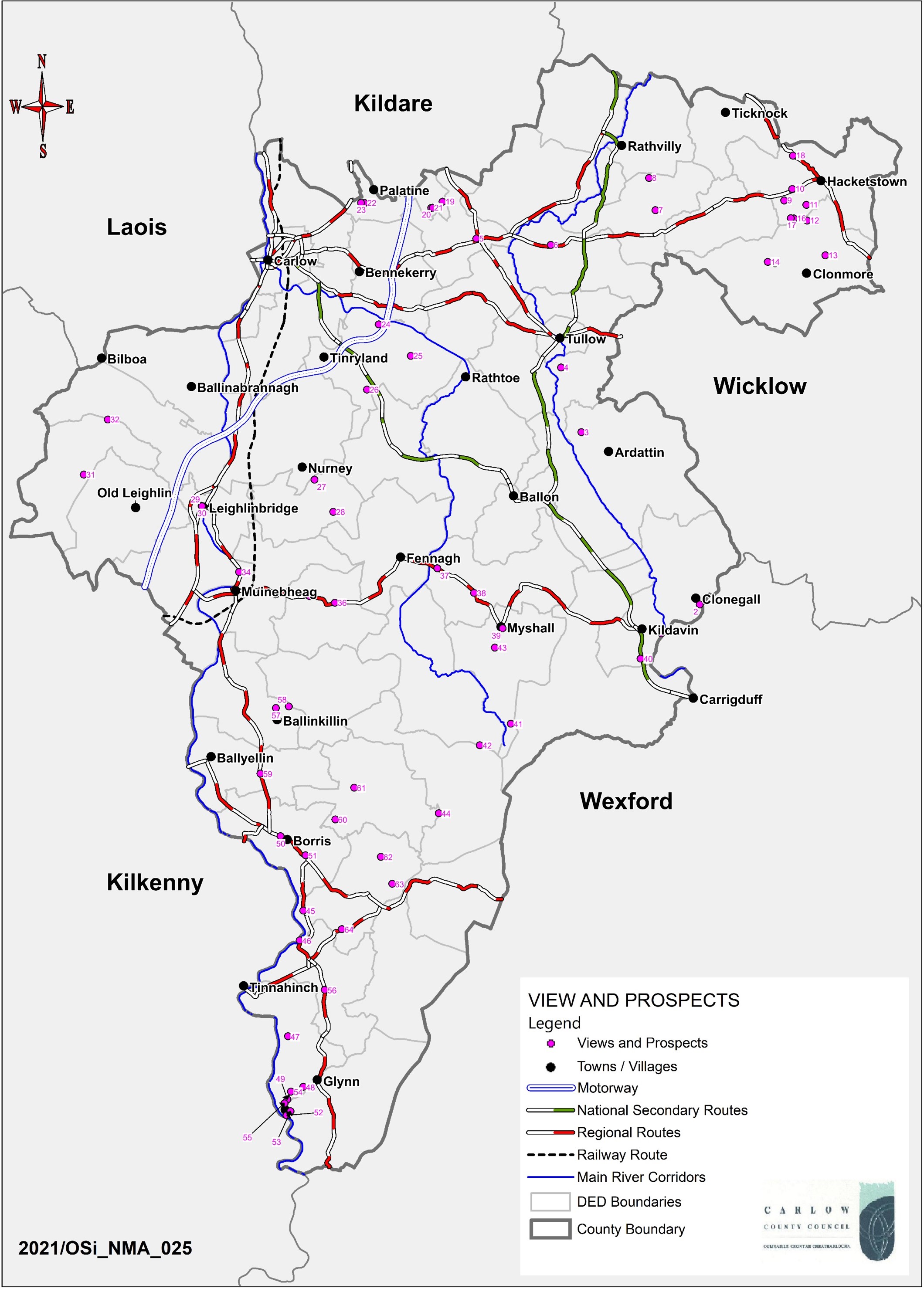 Map 9.4 Views and Prospects
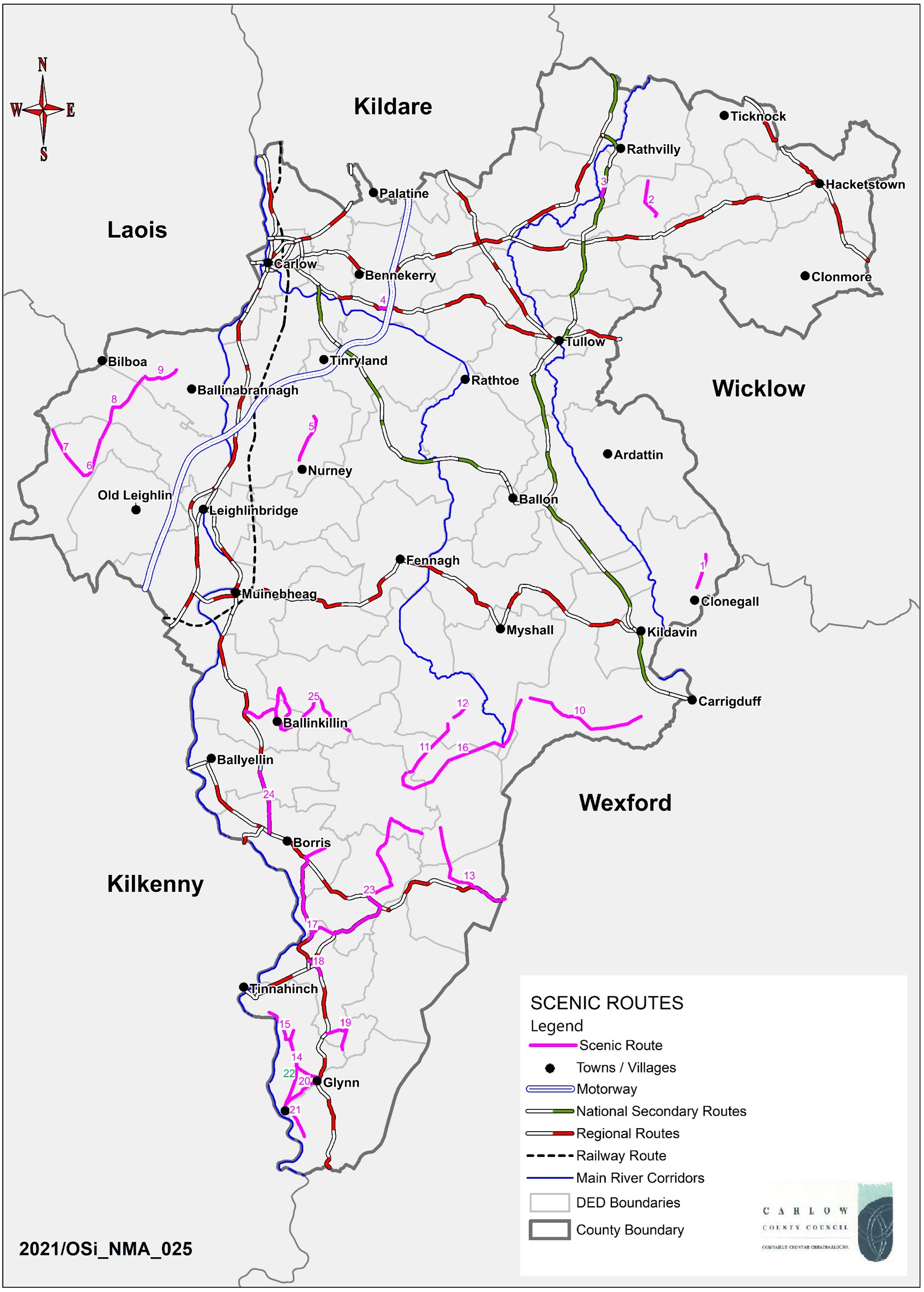 Map 9.5 Scenic Routes
9.8 Landscape - Policies
It is the policy of the Council to:
| LA. P1: | Protect and maintain the overall integrity of the County’s landscape, by recognising its capacity to sustainably integrate and absorb development, and by ensuring that development protects, retains and, where necessary, enhances the appearance and character of the landscape, and does not unduly damage or detract from those features which contribute to its value, character, distinctiveness and sensitivity e.g. landform, habitats, scenic quality, settlement pattern, historic heritage, amenity, land use and tranquillity. |
| LA. P2: | Ensure that development will not have a disproportionate landscape or visual impact in sensitive upland areas of the County (due to siting, layout, design or excessive scale and bulk) and will not significantly interfere with or detract from scenic upland vistas, when viewed from the surrounding environment, including nearby areas, scenic views and routes, and from settlements. |
| LA. P3: | Adopt a presumption against developments which are located on elevated or visually exposed sites or areas with open exposed vistas, and where the landscape cannot accommodate such development with appropriate mitigation. |
| LA. P4: | Ensure that developments on steep slopes or ridges will not be conspicuous or have disproportionate landscape or visual impacts when viewed from the surrounding environment, including from nearby areas, scenic views and routes, and from settlements. |
| LA. P5: | Protect and maintain the landscape quality and visual integrity of river valleys and river corridors, and to ensure development in these sensitive landscape areas does not adversely affect or detract from scenic views, including views from bridges, or from distinct linear sections such as open floodplains. |
| LA. P6: | Require all developments, having regard to their landscape setting, to be appropriate in siting, layout, design and scale, in order to ensure any potential adverse or landscape and visual impacts are minimised and/or removed where necessary, and that natural site features and characteristics are retained and maintained. |
| LA. P7: | Facilitate, where appropriate, developments that have a functional and locational requirement to be situated on steep or elevated sites (e.g. reservoir, telecommunication masts or wind energy structures) where residual adverse visual impacts are minimised or mitigated. |
| LA. P8: | Require, where appropriate, Landscape/Visual Impact Assessments to be prepared by suitably qualified professionals, for development proposals which may have significant landscape or visual impacts, and/or which are located within or adjacent to sensitive landscapes. |
| LA. P9: | Have regard to the potential for screening vegetation when evaluating proposals for development within the uplands. |
| LA. P10: | Ensure that features which contribute to local landscape character, including historic features and buildings, trees, hedgerows, shelter belts and stone walls, are retained, protected, and enhanced where appropriate, so as to preserve the appearance and local landscape character of an area, whilst supporting sustainable landscape change and development. Development proposals necessitating the removal of such features will be discouraged. |
| LA. P11: | Protect and preserve the established appearance and aesthetic attributes of views and prospects that contribute to the inherent quality of the County’s landscape, including views, prospects and scenic routes listed in Tables 9.3 and 9.4 , and particularly views to and from mountains, hills, river valleys and river corridors, and views of historical or cultural value (including buildings and townscapes) and views of natural beauty. |
Landscape - Objectives
It is an objective of the Council to:
| LA. O1: | Ensure that the management and assessment of development throughout the County takes account of the recommendations and assigned Landscape Character Areas, Landscape Types, and Landscape Sensitivity, and the Schedule of Views, Prospects and Scenic Routes, as contained in this Plan, and in accordance with Government Guidance on Landscape Character Assessment and the National Landscape Strategy. |
| LA. O2: | Ensure landscape/visual impact assessment will be a key consideration in the assessment of development proposals within the County. |
9.9 Green Infrastructure
The European Commission’s (EC) 2013 publication entitled ‘Building a Green Infrastructure Landscape’, details that “Green Infrastructure can be broadly defined as a strategically planned network of high quality natural and semi-natural areas with other environmental features, which is designed and managed to deliver a wide range of ecosystem services and protect biodiversity in both rural and urban settings”. The term green infrastructure gives greater recognition to the natural environment as an asset that provides a range of benefits from nature to people, including the provision of clean water, better health and human wellbeing, flood alleviation and improved habitats for wildlife. Potential green infrastructure can include:
- Areas of high biodiversity e.g. protected sites under the Natura 2000 Network and
- Healthy functioning ecosystems outside of protected sites;
- Natural and semi-natural area e.g. rivers, woodlands, wetlands, floodplains, scrub and grassland;
- Green corridors e.g. riverbanks, hedgerows, green roadside verges, and cycling and walking routes;
- Amenity spaces e.g. play areas, playing fields, and public open spaces in housing estates;
- Parks and gardens e.g. town parks and formal country demesnes;
- Domestic gardens, street trees and civic spaces in urban areas.
To qualify as green infrastructure environmental features must be of high quality and must also be capable of delivering more than simply green spaces. For example, a town park that contains areas of uniform grass and no other environmental features is unlikely to qualify as green infrastructure. However, a park that acts as a cool air corridor, that absorbs excess surface water run-off, and which functions as a space for recreation and wildlife, may be considered as green infrastructure.
Natura 2000 sites in the County, as well as proposed Natural Heritage Areas, can lie at the core of green infrastructure, and provide a strategic focus for improving the natural environment and enhancing quality of life. However, it is important to note that there are substantial areas of land that occur outside of protected sites and which include high biodiversity areas and healthy functioning ecosystems that can equally form part of the County’s green infrastructure network.
The European Commission’s recently published EU Biodiversity Strategy for 2030 emphasises the importance of biodiversity, on which “we are fully dependent on and which gives us the food we eat, filters the water we drink, and supplies the air we breathe. Nature is as important for our mental and physical wellbeing as it is for our society’s ability to cope with global change, health threats and disasters”. The strategy refers to the link between our own health and the health of ecosystems, and places significant importance on the role of green infrastructure and nature-based solutions in the protection and restoration of biodiversity. The strategy advises that green infrastructure and nature-based solutions should be systematically integrated into urban planning, including in public spaces, infrastructure, and the design of buildings and their surroundings.
At a national level in 2010, Comhar Sustainable Development Council published their study entitled ‘Creating Green Infrastructure for Ireland, Enhancing Natural Capital for Human Wellbeing’. The study proposed an approach and set of principles that should be followed in green infrastructure planning and set out how green infrastructure might be identified and mapped.
Green infrastructure planning is the subject of policy objectives in Project Ireland 2040 - National Planning Framework, and in the Regional Economic and Spatial Strategy (RSES) for the Southern Region. Both documents give recognition to the environment as an asset, which if planned for in the same way as other forms of infrastructure, can provide long term benefits. There is therefore an emphasis on protecting and valuing important and vulnerable habitats, landscapes, natural heritage and green spaces.
The incorporation of Green Infrastructure (GI) in spatial planning is also one of the ways in which the National Biodiversity Action Plan 2017-2021 seeks to address the main drivers of biodiversity loss in Ireland. This is particularly noteworthy for County Carlow, which is predominantly a rural county, and in which there is a need to ensure development avoids the fragmentation of landscape features, including ecological corridors which allow for the mobility of plant and animal species.
The Council’s Climate Change Adaptation Strategy 2019-2024 identifies a number of adaptation objectives and actions for which green infrastructure and nature-based solutions are to play a key role. This includes the incorporation of green infrastructure, including urban greening, into the design, planning and construction of roads, community and public realm projects, and as a mechanism to promote biodiversity, reduce habitat fragmentation, and for carbon offset. Within County Carlow there are opportunities to expand and strengthen the green infrastructure network and to further explore its integration into both public and private developments in the future.
9.10 Benefits of Green Infrastructure
Green infrastructure aims to protect and enhance nature’s ability to deliver on benefits which the EC (2013) broadly categorises as follows:
- Foster a better quality of life and human well-being, for instance by providing a high-quality environment in which to live and work.
- Improve biodiversity, for instance by reconnecting isolated nature areas and increasing the mobility of wildlife across the wider landscape.
- Protect us against climate change and other environmental disasters, for instance by alleviating floods and storing carbon.
- Encourage a smarter, more integrated approach to development which ensures that Europe’s limited space is utilised in as efficient and coherent a way as possible.
One of the key attractions of green infrastructure is its ability to perform several functions in the same spatial area. In contrast to most human-engineered or single function ‘grey infrastructure’ such as piped drainage, roads etc., green infrastructure can have the ability to perform several functions that are more robust and sustainable from environmental, economic, and social perspectives. For example, a floodplain ecosystem can contribute to flood prevention, but can also contribute to water filtration, maintenance of the water table, recreation, biodiversity, and to reducing the effects of climate change by acting as carbon storage. Green spaces such as town parks may also qualify as green infrastructure if they act as a cool corridor, absorb excess water run-off, and offer an attractive outdoor space for wildlife and recreation.
While the requirement for traditional grey infrastructure will always exist, it must also be recognised that in many cases there are opportunities for it to be supplemented and reinforced with solutions provided by nature.
9.11 Green Infrastructure – A Strategy for Carlow
It is the Council’s intention to develop a Green Infrastructure Strategy for the County in consultation will all key stakeholders and with the public during the lifetime of this Plan.
The Strategy will identify key green infrastructure aims and objectives for County Carlow, taking account of the priority projects identified in this Development Plan and it will provide for the delivery of these projects including the provision of appropriate funding mechanisms.
Table 9.5 Benefits of Green Infrastructure
|
Environmental Benefits |
Social Benefits |
|
Removal of pollutants from air and water |
Improved health and well-being |
|
Provision of clean water |
Increased tourism and recreation opportunities |
|
Rainwater retention |
Diversification of local economy |
|
Improvement of land quality |
Jobs and educational opportunities |
|
Increased pest control |
More attractive and greener towns and villages |
|
Pollination provision |
More integrated transport and energy solutions |
|
Mitigation of land take and soil sealing |
|
|
Climate Change Mitigation and Adaptation Benefits |
Biodiversity Benefits |
|
Flood alleviation |
Improved habitats for wildlife |
|
Strengthening ecosystem resilience |
Reduce habitat fragmentation |
|
Carbon storage and sequestration |
Provision of ecological corridors |
|
Disaster prevention (storms) |
Buffer against climate change for habitats and species |
|
Mitigation of urban heat island effects |
|
Green Infrastructure - Policies
It is the policy of the Council to:
| GI. P1: | Identify, protect, maintain, and enhance existing and planned green infrastructure assets in the County, and recognise the wide range of environmental, social, and economic benefits of green spaces and nature-based solutions by ensuring the integration of green infrastructure planning and development in the planning process. |
| GI. P2: | Protect and enhance the biodiversity and ecological function of the County’s green infrastructure network. |
| GI. P3: | Protect and preserve landscape features which contribute to green infrastructure in the County, including trees, hedgerows, woodlands, wetlands, watercourses and other habitats. |
| GI. P4: | Require all new development to contribute to the protection and enhancement of existing green infrastructure and the delivery of new green infrastructure, as appropriate. |
| GI. P5: | Restrict development that would fragment or prejudice landscape features and ecological corridors which significantly contribute to the County’s green infrastructure network. |
| GI. P6: | Require proposals for large scale developments such as road or drainage schemes, wind farms, solar farms, residential schemes, industrial parks or retail schemes, to submit a green infrastructure plan as an integral part of a planning application. |
| GI. P7: | Promote a network of walking and cycling trails to enhance accessibility to the County’s green infrastructure network, and ensure such proposals are subject to route/site selection processes so that impacts to biodiversity and nature conservation interests are avoided. |
| GI. P8: | Incorporate elements of green infrastructure into existing areas of hard infrastructure, where possible, thereby integrating these areas of the existing urban environment into the overall green infrastructure network. |
| GI. P9: | Ensure Local Area Plans protect and manage the green infrastructure network in an integrated and coherent manner and add additional green infrastructure where possible. |
| GI. P10: | Work collaboratively with other neighbouring Local Authorities in facilitating and supporting the development of cross-border green infrastructure networks. |
Green Infrastructure - Objectives
It an objective of the Council to:
| GI. O1: | Prepare a Green Infrastructure Strategy for County Carlow in accordance with international best practice and in partnership with key stakeholders and the public. |
| GI. O2: | Ensure the Green Infrastructure Strategy for County Carlow reflects a long-term perspective, including the need to adapt to climate change, and recognises and promotes the benefits that can be achieved for the County’s biodiversity, landscape, natural and cultural heritage, open space and recreation, and sustainable water management. |
9.12 Green Infrastructure in Urban Areas
The green infrastructure threaded through towns and villages provides a wide range of benefits, such as reducing air, water and noise pollution, providing flood protection and more attractive urban spaces, while also maintaining a valuable connection between people and nature. The value of these green spaces can be in the connections they provide from urban centres to the surrounding countryside, thereby reinforcing the County’s green infrastructure network. The recent lockdowns due to the COVID-19 pandemic have also highlighted the value of green urban spaces for overall societal health and well-being.
There are many potential components of green infrastructure in urban environments, ranging from domestic gardens, allotments, street trees and verges, to town parks, public open spaces in housing estates, playing fields, woodlands, hedgerows, rivers and streams. In many cases the greening of urban areas can focus on quantity rather than ecological quality and function. For example, levelled grassed areas can provide ease of maintenance but in turn have limited eco-system benefits. New developments in urban areas should therefore ensure that quality takes precedence through the incorporation of ecosystem benefits e.g. retention of existing and/or the provision of new areas rich in biodiversity such as treelines, hedgerows, wild meadows, and wetland areas, which can be provided in conjunction with recreational amenity.
Green Infrastructure in Urban Areas - Policies
It is the policy of the Council to:
| GI. P11: | Ensure that green infrastructure informs the development management process, and that all new developments in urban areas contribute towards the protection, maintenance, and enhancement of existing green infrastructure in terms of siting, layout, design, and landscaping. |
| GI. P12: | Encourage and support the incorporation of elements of green infrastructure and biodiversity into all new developments in urban areas, including the design of buildings and their surroundings (e.g. tree planting, green spaces and verges, planters, green roofs, living walls, bird boxes, bat roost sites etc.), and that contributes to and links with the wider green infrastructure network, in particular where similar features exist on adjoining sites. |
| GI. P13: | Ensure that green areas and open spaces associated with new residential developments and other relevant projects provide multifunctional benefits that enrich quality of life for local communities, ecologically rich areas that enhance biodiversity, and sustainable water management. |
| GI. P14: | Take account of Inland Fisheries guidance ‘Planning for Watercourses in the Urban Environment, A Guide to the Protection of Watercourses through the use of Buffer Zones, Sustainable Drainage Systems, Instream Rehabilitation, Climate/Flood Risk and Recreational Planning’ (2020) when considering development proposals in the vicinity of rivers and streams in urban areas. |
9.13 Green Infrastructure and Sustainable Urban Drainage Systems (SuDS)
Sustainable drainage is a concept that includes long term environmental and social factors in decisions about drainage. It takes account of the quantity and quality of runoff, and the amenity value of surface water in the environment. Many existing urban drainage systems can cause problems of flooding, pollution or damage to the environment and are not proving to be sustainable. Surface water drainage methods that take account of quantity, quality and amenity issues are collectively referred to as Sustainable Drainage Systems (SuDS). These systems are more sustainable than conventional drainage methods because they:
- Manage run off flow rates, reducing the impact of urbanisation on flooding;
- Protect or enhance water quality;
- Are sympathetic to the environmental setting and the needs of the local community;
- Provide a habitat for wildlife in urban watercourses;
- Encourage natural groundwater recharge (where appropriate)
SuDS therefore represents a move away from the conventional practice of piping all surface water directly to the nearest river or stream towards an approach were water is either infiltrated or conveyed more slowly to water courses via constructed wetlands, permeable surfaces, filter strips, ponds, swales, basins, and green roofs, all of which contribute to more environmentally friendly and aesthetically pleasing methods of controlling surface water. SuDS features are widely recognised as a form of green infrastructure and have the potential to contribute significantly to the urban green infrastructure network. SuDS also have the ability to perform a multi-functional role that can create space for surface water management, as well as for biodiversity, recreation and amenity. Polices and objectives pertaining to Sustainable Drainage Systems are contained in Section 6.5, Chapter 6 Infrastructure and Environmental Management.
Clár ábhair
Tuairimí
Tuairimí
Green Infrastructure/ Regeneration Strategy
The Carlow County Development Plan review will ‘’deal with biodiversity and environmental protection’’……, it refers to the United Nations...
We would like you to appoint a biodiversity officer for Carlow. This role would give someone the scope to create a plan for protecting and enhancing the biodiversity in County Carlow and it is...
The planning department team at Carlow County Council are to be congratulated on drafting a very comprehensive document for 2022-2028 and providing an opportunity for making submissions on the...
I am asking you to please provide a biodiversity officer for the county. It is an absolute necessity at this point. We are in the midst of a huge crisis for our wildlife. We humans...