Chapter 15: Borris Plan
Vision
To maintain the attractive architectural character and natural heritage of Borris with an emphasis on promoting regeneration and healthy placemaking, addressing vacancy and dereliction thereby creating a vibrant town centre with an appropriate mix of uses and employment opportunities, whilst pursuing a high quality of development that respects the distinctive characteristics of the natural and built environment.
15.3.4.1 Location and Context
Borris is situated in a predominantly rural setting in the south of the County, at a distance of 35km from Carlow Town. It is a location with a rich cultural and built heritage, set within a very picturesque natural environment that is a gateway to Mount Leinster and the Blackstairs Mountains. The town is a Georgian settlement and much of its built heritage such as granite houses and Victorian shopfronts, remain intact. The majority of the built fabric of the town is located along a steeply rising Main Street. The street is defined and enclosed on its southern side by the presence of the very substantial demesne walls of Borris House. Borris is served by two regional road routes, one from New Ross Port (R729) which continues to the midlands, and the other (R702) serving the Wexford/ Enniscorthy /Kilkenny route, with direct access to the M9.
|
Borris |
|
|---|---|
|
Position in Settlement Hierarchy |
Small Town |
|
2016 Population |
652 |
|
2011 Population |
646 |
|
% Change 2011-2016 |
0.9% |
|
Households |
226 |
|
Committed Units not yet Built |
9 |
|
Core Strategy Housing Allocation |
62 |
|
Population Projection 2028 |
793 |
|
Education Facilities |
Primary School & Secondary School |
|
Community Facilities |
Community Centre |
|
Architectural Conservation Areas |
Yes |
|
Protected Structures |
44 no. |
|
Zone of Archaeological Potential |
None |
|
Record of Monuments and Places (RMP) |
4 no. sites |
|
Natura 2000 Sites |
The Mountain River, a tributary of the River Barrow, flows across the south eastern end of the town and is designated as part of the River Barrow and River Nore SAC (Site Code: 002162). |
|
Water Services Infrastructure / Capacity |
Sufficient capacity exists in Water and Wastewater Infrastructure to accommodate development |
15.3.4.2 Settlement Form and Function
Borris has a very distinct character and settlement form, arising from key 19th century developments comprising Borris House and Demesne, the railway station, railway line and viaduct. The town originally developed in a linear manner along the Main Street, with the majority of buildings located on the northern side of the street, with stone walls bordering the southern side, defining the boundary with Borris House and estate. The stone granite walls are an important feature of the town and create a strong sense of enclosure. A landscaped linear park also runs parallel to the southern side of the Main Street. The character of the town is also informed by a network of historic lanes at the northern side of the town, some of which link with the route of the former railway line.
Borris House and the former railway viaduct are two of the most unique and prominent features of the town. However, the built heritage throughout the town creates a very defined character, and is reflected in gothic style architecture, traditional shopfronts, and a wide use of granite.
The modern growth of Borris features residential development on the western approach to the town such as at Lodge Court, Woodlawn Park and Oaktree Court. Industrial development and a cattle mart are located to the north of the town along the Fenagh Road.
There are three main entrance roads to Borris, comprising the R702 which traverses through the town centre, the R705 and R729. Each entrance to the town comprises rural land transitioning into residential linear built housing.
Borris functions as a local service and retail centre for a large rural catchment area, including persons from nearby County Kilkenny. The local daily service needs of the town are met by a bank, credit union, post office, retail convenience stores, butchers, hairdressers, barbers, café, food take-aways, banking, a traditional drapery and footwear shop, and gift shop.
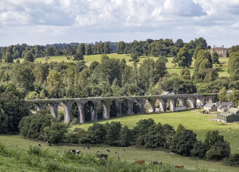
View of Borris Viaduct
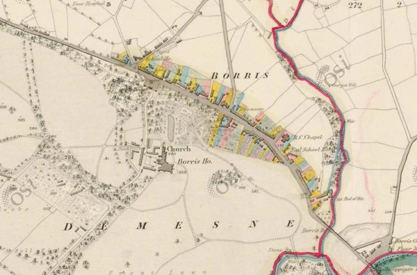
Historic Map 6 Inch Colour (1837-1842) of Borris - note absence of railway and viaduct (Source: www.osi.ie)
15.3.4.3 Population and Socio-Economic Profile
According to the 2016 Census data, Borris has a population of 652, representing a small increase of 0.3% on the previous 2011 Census figure of 646.
Population Demographic/ Nationality
The age profile of Borris is considerably older than the National and County averages. A total of 25.3% of the population is over the age of 65 years, compared to the national average of 13.4% and the overall County average of 12.9%. Only 25.2% of the population are under the age of 24 years (national average of 33.2%). While 25.2% of the population are under the age of 24 years, compared with the national average of 33.2%. Non-Irish nationals accounted for 10.3% of the population of Borris in 2016 which is just below the share for the County (10.5%).
Economic Profile
The 2016 Census identified that there were 284 persons in the labour force i.e. aged 15 years and over who were able to work; excluding students, retired, those looking after family or unable to work due to illness or disability. Of this labour force 79.2% were in employment (225 persons).
Borris recorded an unemployment rate of 20.8% (2016 data), which was notably above the national rate of 12.9%. Of persons not in the labour force, 23% were retired, 6.9% were students (aged 15 years and older) and 6.4% were unable to work due to illness or disability.
‘Skilled manual’ is one of the largest socio-economic working groups in Borris with 18.6% of the population in this social group, a rate above the national average of 14.1%. A further 14.6% of the population are identified as ‘Semi-skilled’, which is also above the national average rate (10.5%). This is reflective of the strong engineering industry in the locality. Other main centres of employment for residents of the town are Muine Bheag, Kilkenny and Carlow Town.
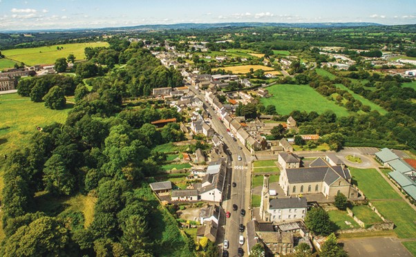
Aerial view of Borris looking west along Main Street (Source: www.borrisviaduct.ie)
15.3.4.4 Housing
There were 226 households recorded in the 2016 Census. From 2001 to 2010, 18% of the town’s housing stock was constructed. One and two-person households make up approximately 56% of all households. 57% of units are owner occupied. Socially rented Local Authority housing accounted for 24% of households, which was over double the County average of 11.8%.
The housing target for Borris identified in the Core Strategy in Chapter 2 is 62 new residential units over the Plan period from 2022-2028.
The Plan will promote a policy of consolidation focused on localised growth through the development of infill and brownfield lands. Any development shall respect the character and setting of the town and make a positive contribution to its built environment.
15.3.4.5 Social Infrastructure
Borris is served by a primary and a secondary school, which also cater for a broad hinterland. The national school, Borris Mixed National School, accommodates 215 pupils. The secondary school, Borris Vocational School, accommodates 532 pupils.
A nursing home located in the town caters for up to 52 older persons.
There are a number of community organisations within the town, and Borris Town Hall and Parish Centre hosts a large number of community events, however the capacity of these centres to host some activities e.g. sporting or arts activities is limited and there appears a need for enhanced community facilities.
Sports facilities include Mount Leinster Rangers GAA and Borris Golf Club, located to the southeast of the town and outside of the development boundary.
The southern side of Main Street adjoining the Borris House estate includes a public playground, and a well maintained and attractive linear park with seating and picnic areas. The playground includes an astroturf pitch for soccer and basketball.
There is a catholic church located in the town centre (Sacred Heart Catholic Church), and a cemetery to the south of the town with parking and access off the R702.
The recreational and amenity offering in the town has been enhanced through the Council’s recent completion of the Borris Railway Viaduct Project in 2020. The viaduct is 800 metres in length and over 50 metres above the North Leinster Heritage Drive and Mountain River. The project was funded under the Rural Regeneration and Development Fund. The viaduct has been redeveloped and upgraded to link with the town’s amenities and to contribute to a safe network of walking routes, which capitalise on the unique vistas available from the viaduct and from local roads.
Borris - Our Vision A Shared Vision completed in 2019 is based on a number of core ambitions for the future of Borris and include:
- An Easy Place To Get Around: focusing on good quality accessibility and connectivity throughout the town and to adjoining villages/ amenities for all modes of transport.
- A Good Place to Grow Up and Grow Old: maintaining vibrancy and vitality in the town, accommodating all age groups with inclusive community decision making.
- Keeping it Special: preserving the uniqueness of Borris, planning for growth and addressing vacancy and dereliction.
- A Place to Make a Good Living: focusing on employment opportunities and growth within the town.
- A Welcoming Place: celebrating the unique heritage of the town, promotion of tourism assets and improving the public realm.
It is an objective of this plan to support the implementation of Borris Our Vision, where feasible.
15.3.4.6 Economic Development
Borris is designated as a level 3 Small Town under the Retail Hierarchy for the County, having a more limited retail role and function than higher order settlements, with provision typically restricted to services and convenience shopping.
The town functions as a local services and retail centre for a large rural catchment area. Services and retailing include a bank, a credit union, a post office, retail convenience stores, butchers, hairdressers, barbers, café, food take-aways, banking, a traditional drapery and footwear shop, and a gift shop. There are also a number of other service providers located on the Main Street including an insurance broker.
The Main Street has a number of public houses, some of which appear to be permanently closed, however, the shopfronts have been maintained to reduce the impact and appearance of vacancy.
Other commercial activity in the town includes a steelwork and hardware store at the eastern end, and a petrol service station and agricultural machinery dealership at the western end.
Visitor accommodation is limited in the town, with the Step House Hotel the main provider. Borris House and estate located to the southwest of the Town is a high-quality amenity and attracts a high number of visitors annually, in addition to hosting planned events.
The majority of industrial activity is located to the northeast of the town centre, along the Fenagh Road, with many of the industries specialising in engineering. The cattle mart is also sited on the Fenagh Road.
15.3.4.7 Vacant / Derelict Units and Sites
Vacancy and dereliction can have an adverse effect on the vitality and visual amenity of a town. Vacant shops on the Main Street are largely maintained in such a manner so as to detract as little as possible from the streetscape.
In 2016, 12.5% of housing units were recorded as vacant in Borris, which was higher than National (9.1%) and county (8%) averages for the same year.
15.3.4.8 Regeneration/Redevelopment Opportunities
The Council promotes and supports the use of previously developed brownfield and infill sites within the established built footprint of Borris, as well as the redevelopment of existing sites and buildings. This will contribute to:
- Securing more compact and sustainable growth.
- Enhancing the public realm and overall character and appearance of the town.
- Retaining and increasing vibrancy and vitality in the town centre, including viability for local services, shops, and public transport.
- Increased opportunities for sustainable travel such as walking and cycling.
Development proposals on brownfield, infill and backland sites must be accompanied by a Site Brief. The Site Brief must demonstrate how a proposal incorporates principles of good urban design and placemaking as contained in Chapter 12, as well as compliance with national policy and guidance on the achievement of compact growth.
15.3.4.9 Intervention Area – Kelly’s Steelworks Site
Located at the southern end of the town, this key site is positioned to the immediate west of the former railway viaduct. All boundaries of the site adjoin public roads, including the R702 to the west leading to the town centre Main Street, and the L3006 Rathanna road to the north, which is also a route to the South Leinster Way and the Hidden Sky Road. Borris Vocational School is to the immediate north of the site and is accessed from the Rathanna Road.
The site is currently in use for industrial / storage purposes, and most of its c. 1.3ha area is in use as an open storage yard. The site has historical significance for the town, being the site of a former corn mill (Scortreen Mill). The mill building is still in situ at the southern boundary of the site and is designated as a protected structure (RPS Ref. CW356). The building is a very fine, early-19th century mill building of four storeys, built of large blocks of coursed-rubble granite.
The recent redevelopment of the viaduct as a civic amenity has highlighted the significant economic and tourist potential of sites in its immediate vicinity. This underutilised site represents a significant opportunity for the regeneration of this part of the town, with potential to provide an appropriate mix of uses that would:
- Enhance the vitality, character, and appearance of the town;
- Incorporate heritage-led regeneration and reuse of Scortreen Mill; and,
- Capitalise on a strategic location next to the viaduct to build on and enhance the economic/ tourist/recreation offering in the town.
Any development proposals for the site should be informed by the policies and related provisions in Chapter 10 for built heritage. There will therefore be a requirement that best conservation practice is utilised to respect and protect the character and setting of the viaduct and the mill building as protected structures.
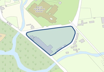
Map 15.3.4.1: Intervention Area – Kelly’s Steelworks Site
15.3.4.10 Movement and Transport
Borris is served by two regional road routes, one from New Ross Port (R729) which continues to the midlands and the other (R702) serving the Wexford / Enniscorthy / Kilkenny route, with direct access to the M9. The M9 interchange at Paulstown is c. 16km northwest of Borris. The town is also served by the local road network radiating to the surrounding agricultural hinterland. The rail network in Borris has been abandoned since the early 1960s.
There are no significant traffic issues in Borris. Physical traffic calming measures are in place on the carriageway at the Sacred Heart Church (northbound) and the children’s playground (southbound). There are also speed ramps on the approach from each direction to Borris Vocational School.
On-street parking in Borris is provided along Main Street. Some backland areas off the Main Street also provide parking, such as the Step House Hotel. Some backland areas off the Main Street also provide parking, such as the Step House Hotel.
Some improvements are required to footpaths where surfaces are uneven. There are currently no designated cycle paths in the town, which would improve linkages between the Main Street and locations such as Borris Vocational School and the Mount Leinster Rangers GAA Grounds.
The redevelopment and adaptation of the Borris Viaduct as a civic amenity makes an important contribution to sustainable travel and mobility in the town and to existing walking routes. There is further potential to develop such routes in the area, by utilising and linking in with historic lanes (e.g. Bog Lane, Pound Lane, Bottle Lane, Moloney’s Lane) and the disused route of the Carlow to Wexford railway line to which the viaduct formed part of. Under the Carbon Tax Fund 2020 and as part of a Barrow Valley Greenway Initiative, the Council received funding in 2020 to investigate the feasibility of developing a greenway in the County utilising the route of the disused Carlow to Wexford railway line. The development of such a greenway if viable would significantly boost the recreational and tourism opportunities in the area and provide possibilities for linkages with similar infrastructure in adjoining counties.
Ringalink operates an on-call door to door bus service which links Borris to New Ross, Bagenalstown and Carlow. The Ringalink service has a schedule but no fixed routes, its remit being to provide rural transport where needed for registered users.
15.3.4.11 Water and Environmental Services
From 2020 Irish Water data, the existing design capacity of the Borris Wastewater Treatment Plan is 1,500 PE and has an available spare capacity of 496 PE.
The source of the water supply for Borris and its environs is the Mountain River. The Borris Water Treatment Plant implemented a significant upgrade which increased the design capacity of the plant from 200m³/day to 300m³/day.
Domestic, commercial and industrial waste are collected and disposed from Borris by private operators. Borris Recycling Bring Bank is located off Main Street, and caters for the collection of glass, cans and paper.
The Council encourages recycling and the minimisation of waste through its environmental education programme and the Green-Schools programme.
15.3.4.12 Public Realm
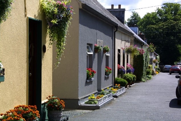
Borris is located in a predominantly rural setting, with the Blackstairs Mountains clearly visible on the horizon, southeast of the town. The rich built heritage of the town incorporating gothic style architecture, with granite stone used widely throughout the town in pillars, walls, steps, window and door surrounds contributes significantly to the visual and architectural heritage of the town. These distinctive architectural features, combined with the traditional shopfronts, rich natural environment comprising trees, hedgerows and the Black River Valley and Blackstairs Mountains landscapes, provide a distinctive character to the town and its streetscapes.
While the attractive appearance of the town is rooted in its built heritage features, its upkeep and presentation is also a result of community effort and a sense of local pride. The shops, houses and other commercial premises in the town are by and large well maintained and presented, with many retaining traditional shop fronts. Many of the shop fronts are faced with stone adding to the character of the town and highlighting its built heritage, while other premises have rendered facades and are traditionally decorated.
The Council in co-operation with local communities, businesses and other relevant stakeholders are seeking to continually improve the physical presentation and appeal of many towns in the County such as Borris, both through the planning process, initiatives such as Pride of Place, County Tidy Towns, and through funding from the Town and Village Renewal Scheme. Borris has been the subject of Pride of Place and Tidy Towns awards.
15.3.4.13 Natural Heritage
The town is in close proximity to the River Barrow and River Nore Special Area of Conservation (SAC) at its southeast end. It is at this location that the Mountain River, a tributary of the River Barrow and part of the SAC, flows from east to west under the former railway viaduct. At its closest point the River Barrow is c. 1km to the southwest of the town. The Dinin or Black River flows through land at the northern side of Borris, and discharges into the Mountain River south of Borris Bridge on the Borris House estate.
15.3.4.14 Architectural Heritage
The built heritage of Borris gives the town a uniqueness of character. The sixteen-arch viaduct with arches supported by large limestone piers, is a striking example of monumental-style railway engineering. It was designed by the engineer William Le Fanu (1816 –1894) and built by John Bagnall.
Borris House and estate is a picturesque country house with a unique history that can be traced back to the ancestral home of the MacMurrough Kavanaghs, Kings of Leinster.
One of the most outstanding characteristics of Borris are the Gothic style features which can be observed especially in door surrounds, where the arch forms an ogee. Projecting door surrounds in three dominant types – rectangular, with arch or ogee – are important details of Borris architecture.
The examples referred to, as well as numerous other buildings and structures in Borris, are recorded in the Record of Protected Structures and by the NIAH (See Table 15.3.4.1). Chapter 10 of this Plan outlines policies and objectives for protecting architectural heritage within the County.
15.3.4.15 Architectural Conservation Area (ACA)
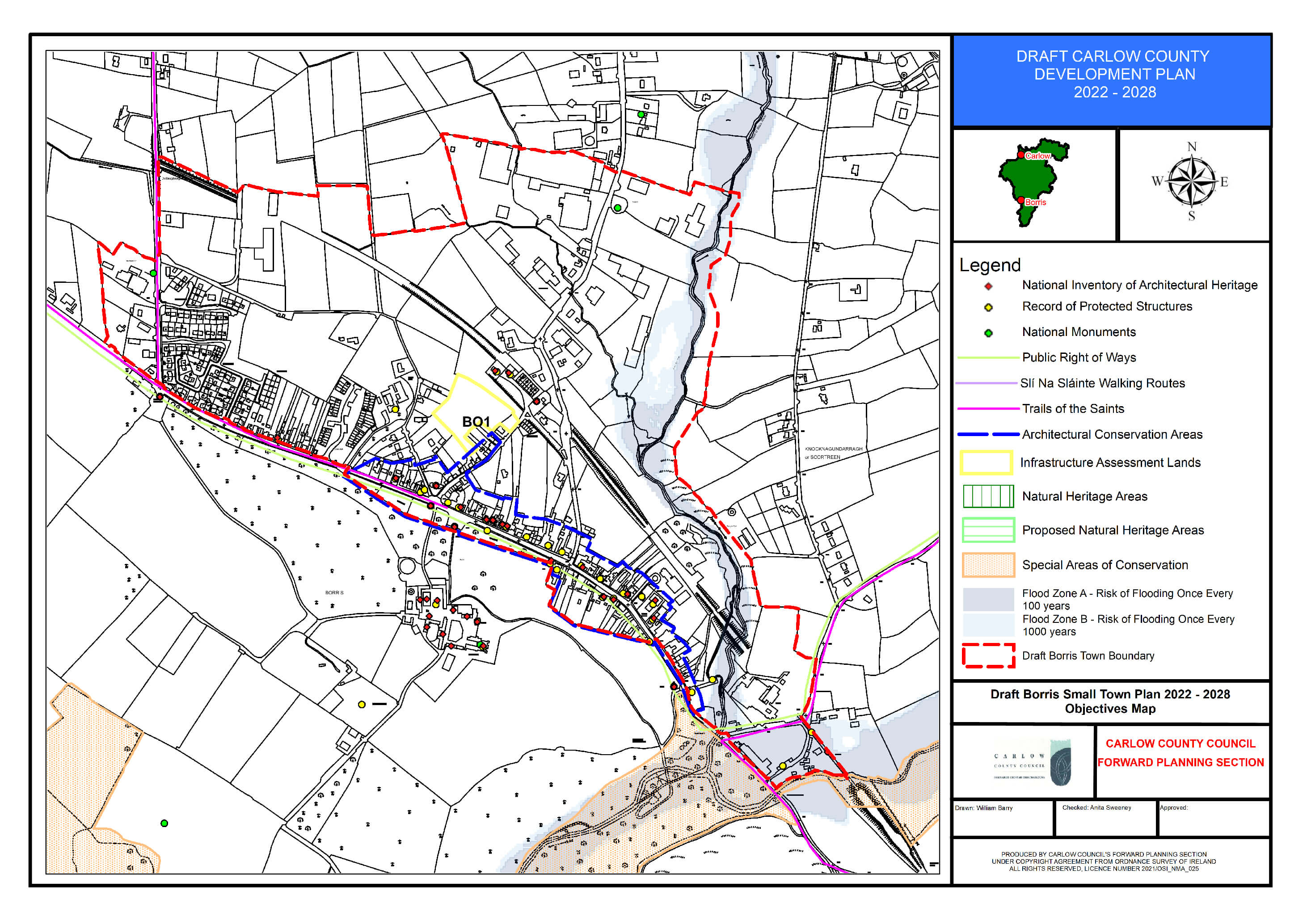
Borris has been designated as an ACA. This is in recognition of the significance of the built heritage of the town, and its contribution to the character and attractiveness of the area. The defined boundary of the ACA can be viewed on the Borris Land Use Zoning Map. (Refer to Chapter 10: Section 10.15 Architectural Conservation Areas for applicable policies and objectives).
|
RPS Ref |
NIAH Ref |
Description |
Address |
|---|---|---|---|
|
CW36 |
10400803 |
The chapel is a three-bay church designed in the Tudor-gothic style by the Morrisons and was once linked to the house. |
Borris House Chapel, Borris House, Borris |
|
CW37 |
10400802 |
The house is an 18th century structure remodelled by the Morrisons in the early 19th century in their Tudor-gothic revival style. |
Borris House, Borris |
|
CW57 |
10400830 |
Sixteen-arch limestone built former railway viaduct, c. 1860. Now closed. |
Borris Viaduct, Borris |
|
CW180 |
10400801 |
Mid-18th century entrance gates |
The Dublin Gates, Borris House, Borris |
|
CW181 |
10400805 |
A small gate lodge |
South Lodge, Borris House, Borris |
|
CW182 |
10400804 |
Turret Gates |
Turret Gates, Borris House, Borris |
|
CW183 |
10400802
|
Yard Buildings |
Borris House Yard Buildings, Borris House, Borris |
|
CW184
|
10400802
|
Walled Garden |
Borris House Walled Garden, Borris House, Borris |
|
CW185
|
10400819
|
A three-bay, two-storey, gable-ended house which is set back from the street. The house dates from circa 1835. |
Mitchell’s,Main Street, Borris |
|
CW186 |
10400824 |
A three-bay, two-storey, gable-ended house |
Main Street, Borris |
|
CW187 |
10400818 |
A three-bay, two-storey, gable-ended house of circa 1815 |
Main Street, Borris |
|
CW188 |
10400820 |
A three-bay, two-storey, semi-detached, Tudor-revival house The house dates from circa 1835. |
Main Street, Borris |
|
CW189 |
10400821
|
A three-bay, two-storey, semi-detached, Tudor-revival house. The house dates from circa 1835. |
Main Street, Borris |
|
CW190 |
10400823
|
A six-bay, two-storey terraced house. The house dates from circa 1840 with renovations of circa 1890. |
DJ Nolan Drapers, |
|
CW191 |
10400828
|
Ruin of a four-storey, double-pile cornmill dated 1815. |
Borris Mill
|
|
CW192 |
10302234
|
A canal lock of circa 1790. |
Lock No 16, |
|
CW193 |
10400827
|
The school is an exceptional building having an elaborate tudor-gothic revival façade dated 1832. |
Borris Catholic School, Borris |
|
CW194 |
|
A three-bay, two-storey house which is attached to a similar, gabled house. |
House, |
|
CW195 |
|
A terrace house which is entered from the main street but has a façade set at ninety degrees to the main street. |
House, |
|
CW196 |
|
A three-bay, two-storey house of circa 1840 designed in a mildly gothic-revival style. |
Borris Lodge, |
|
CW197 |
|
A three-bay, two-storey, gable-ended house dating from the early 19th century. |
Burmah Petrol Station House, Main Street, Borris |
|
CW198 |
|
A five-bay, two-storey, terrace house dating from the late 19th century. |
M O’Shea, Main Street, Borris |
|
CW199 |
|
A small, three-bay, two-storey, gable-ended house. |
E. Breen, |
|
CW200 |
|
Three mid-19th century, cast-iron lamp posts with fluted shafts and foliate brackets. |
Lamp Post, |
|
CW201 |
|
A late-19th century hand pump set in circular enclosure with granite posts and steps up to the pump. |
Hand Pump, |
|
CW202 |
|
Late-19th century, cast-iron hand pump set on a granite platform. |
Hand Pump, |
|
CW203 |
|
A simple, two-bay, two-storey, early-19th century house. |
House, |
|
CW204 |
|
A three-bay, two-storey, gable-ended house dating from circa 1840. |
Mill Owners House, Main St, Borris |
|
CW205 |
10302234 |
A simple, three-bay, single-storey, gable-ended cottage. |
Lock Keepers House, |
|
CW206 |
10400826 |
A large, T-plan, barn-church built in 1820. |
Church of the Sacred Heart, Borris |
|
CW207 |
10400825 |
A simple, three-bay, two-storey house. The house dates from circa 1850. |
The Presbytery, |
|
CW208 |
10400811 |
A detached, three-bay, two-story, gothic-revival house dating from circa 1850. |
Garda Station, |
|
CW209 |
10400806
|
The fountain is a memorial to the Hon. A. Kavanagh, erected with money given by his friends and admirers |
Kavanagh Memorial Fountain, |
|
CW210 |
10400807
|
The remains of a cast-iron water pump, dated 1829, set within a circular wall and with a shallow stone trough in front. |
Water Pump, |
|
CW211 |
10400808 |
A seven-bay, two-storey building, and originally three houses amalgamated circa 1890. |
J. Daltons, |
|
CW212 |
10400822 |
A group of buildings which were originally a coaching inn. |
Joyce’s, |
|
CW213 |
10400810
|
A line of semi-detached, single-storey estate cottages originally two bays each. The houses date from circa 1855. |
Borris Estate Cottages, Main Street, Borris |
|
CW214 |
10400816 |
An end-of-terrace, six-bay, two-storey building, dated 1808. |
Coady’s The Step House, |
|
CW215 |
10400817 |
A three-bay, two-storey, gable-ended house over a high basement. The house dates from circa 1835. |
Coady’s The Step House, |
|
CW216 |
10400812
|
A detached, five-bay, two-storey, tudor-revival school and master’s residence with an H plan. The school dates from circa 1830. |
Old School House, |
|
CW217 |
10400813
|
A detached, three-bay, single-storey, gable-ended station master’s house. |
Former Station Masters House, |
|
CW218 |
10400814
|
The former railway station of circa 1855. |
Former Station House, |
|
CW219 |
10400815
|
A small, detached, two-bay, single-storey goods shed converted into a house. |
Former Goods Shed, |
|
CW220 |
10400809
|
Wall-mounted cast-iron Victorian letter box, c. 1880. |
Victorian Letter Box, |
Table 15.3.4.1: Protected Structures and NIAH Listings for Borris
15.3.4.16 Archaeology
Borris has several sites with archaeological significance situated in or within proximity of the town. Chapter 10, Section 10.14 outlines policies and objectives for protecting the archaeological heritage of the County.
|
Ref. No |
Address |
Item |
|---|---|---|
|
CW022-004 |
Borris |
Designed landscape feature |
|
CW022-005 |
Borris |
Ritual Site - Holy Well |
|
CW022-019 |
Borris |
Castle – Unclassified |
|
CW022-057 |
Borris |
Redundant record |
|
CW022-058 |
Borris |
Fulacht Fia |
Table 15.3.4.2: Recorded Monuments in Borris
15.3.4.17 Land Use Zoning
Lands within the development boundary of Borris are zoned for various uses. Zoning objectives are contained in Chapter 16 Development Management Standards.
15.3.4.18 Borris - Policies
The policies set out in this section are in addition to policies and objectives included in all other chapters of this Plan, and therefore should be read in conjunction with same, including the Development Management Standards in Chapter 16.
Settlement Form and Function
It is an objective of the Council to:
| BO. P1: | Support the role of Borris by facilitating high quality development that will contribute to the character and service function of the town and which complements and enhances the quality of its attractive built and natural environment. |
| BO. P2: | Preserve the character of the town by requiring that the height, scale, design and materials of any proposed development respects the character and distinctive built heritage of the town and does not diminish its sense of place. |
| BO. P3: | Encourage the re-use of vacant buildings, the development of infill sites and the refurbishment of derelict buildings to contribute to a compact and vibrant town. |
| BO. P4: | Encourage and promote development within the town which is of a high standard of design, has an appropriate mix of uses, enhances the built environment, and delivers a high-quality built environment. |
| BO. P5: | Support the objectives of “Borris Our Vision Plan”, in so far as is practicable. |
Regeneration/Redevelopment Opportunities
It is the policy of the Council to:
| BO. P6: | Promote and support the use of previously developed brownfield, infill and backland sites in Borris, including the redevelopment of existing sites and buildings, and to continue to identify regeneration opportunities in the town during the lifetime of this Plan. |
| BO. P7: | Encourage the redevelopment and regeneration of the Kelly’s Steelworks Site (See Map 15.3.4.1) with appropriate development that enhances the vitality, character, and appearance of the town, incorporates the heritage-led regeneration of Scortreen Mill, and capitalises on a strategic location next to the viaduct. |
Economic Development
It is an objective of the Council to:
| BO. P8: | Encourage the provision of retail and services to consolidate the town and strengthen the role of Borris in meeting the needs of its population and its rural hinterland. |
| BO. P9: | Facilitate the expansion of the employment and service base in the town and encourage the expansion of existing established enterprises operating in Borris, to facilitate new employment uses and to ensure that future development is compatible with the character and scale of the town. |
| BO. P10: | Support the provision of co-working spaces within the town centre facilitating the establishment of new businesses and remote working opportunities for residents of the town. |
| BO. P11: | Advance Borris as a tourism hub and support further growth of the tourism sector by harnessing the built and natural heritage characteristics of the town including the provision of walking and heritage trails throughout the town. |
| BO. P12: | Support tourism related uses, activities and amenities that complement the natural and built heritage assets of the area including the Viaduct, the River Barrow and Mount Leinster subject to environmental assessments. |
| BO. P13: | Promote and encourage the development of enterprise and employment sites adjoining the viaduct and to support the re-use of these strategic sites for employment uses including tourism and associated uses in a high-quality landscaped environment. |
| BO. P14: | Promote Borris as a hub in a network of walks and outdoor recreation between the Blackstairs and the Barrow. |
Movement and Transport
It is the policy of the Council to:
| BO. P15: | Maintain and improve where appropriate the local road (street) network to ensure a high standard of road quality and safety in the town and to seek to facilitate new access points / road infrastructure as appropriate to backland areas along the main street in order to improve accessibility and permeability to strategic backlands within the town. |
| BO. P16: | Improve the quality, aesthetics and width, where appropriate, of all footpaths in the town and improve access for the mobility impaired. |
| BO. P17: | Promote and facilitate the development and enhancement of footpaths, pedestrian crossings and traffic calming measures which increase pedestrian priority and improve road safety. |
| BO. P18: | Promote and facilitate the development of connected walkways including historic lanes at appropriate locations throughout the town to encourage sustainable transport and recreational opportunities. |
| BO. P19: | Seek to deliver additional parking infrastructure in Lower Main Street (South of the Bank of Ireland) to cater for existing and potential increased demand from ongoing development of the Viaduct as a tourist attraction and of Borris as a tourism hub for the southern part of Co Carlow. |
Housing
It is the policy of the Council to:
| BO. P20: | Support and encourage residential development on residential and town centre lands including under-utilised and/or vacant lands, ‘infill’ and ‘brownfield’ sites, subject to a high standard of design and layout being achieved, and compliance with proper planning and environmental considerations. |
| BO. P21: | Ensure that future growth is balanced and sustainable and is appropriate to the scale, size and character of the existing town. |
Social Infrastructure
It is the policy of the Council to:
| BO. P22: | Work with and support recreational and community groups within the town to enhance recreational amenity. |
| BO. P23: | Support existing public, community, sporting and recreational groups in Borris, in the provision of enhanced facilities to meet the needs of the residential population and that of the surrounding rural hinterland. |
Water and Environmental Services
It is the policy of the Council to:
| BO. P24: | Liaise with and support Irish Water to ensure adequate water services are in place to meet the development needs of Borris within the Plan period. |
Public Realm
It is the policy of the Council to:
| BO. P25: | Support public realm improvements in the town, including where appropriate, the provision of signage, public seating, open space, hard and soft landscaping, and improvements to the public road and footpath network. |
| BO. P26: | Promote and support the utilisation of available funding and the implementation of any projects or schemes for which funding has been received that would contribute towards the maintenance and improvement of the public realm of the town. |
Built and Natural Heritage
It is the policy of the Council to:
| BO. P27: | Protect and enhance the historic character, heritage value and visual setting of the Borris Architectural Conservation Area (ACA) and to carefully consider any development proposals that would affect the special interest of the ACA. |
| BO. P28: | Support the retention of buildings with architectural merit, significant architectural features, historic /heritage structures and archaeological sites that contribute to the towns character and setting. |
| BO. P29: | Protect individual trees, groups of trees, hedgerows and stone walls in so far as possible on all approach roads and within the town which contribute significantly to the character and visual amenity of the town. |
| BO. P30: | Require development proposals to outline how they integrate / respond to green infrastructure and contribute to the development and protection of green infrastructural assets in the town and wider area. |
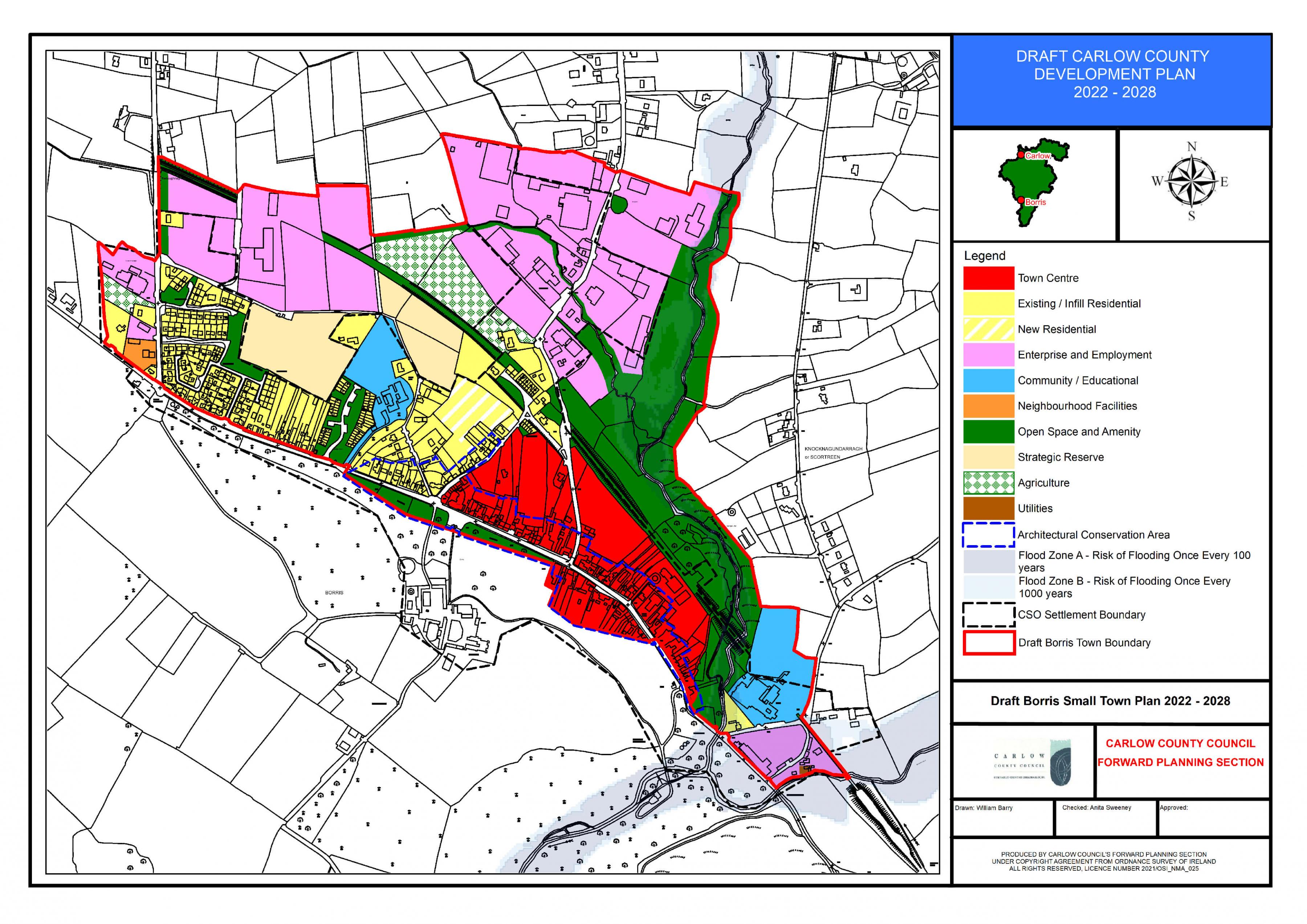
Borris Land Use Zoning Map