Carlow Town has many facilities and amenities that the pupils in our school would like to access as part of their education. We often work with The Visual Gallery on art initiatives, collaborate with...
Chapter 6 - Sustainable Travel and Transportation
Closed13 Dec, 2023, 9:00am - 5 Feb, 2024, 5:00pm
Aim: To promote and develop a sustainable, integrated and universally accessible transport system for Carlow-Graiguecullen that prioritises walking, cycling, and public transport, in addition to the provision of an appropriate level of road infrastructure, road capacity and traffic management, and which supports future development and thereby facilitating the transition to a lower carbon-based climate resilient and healthy urban environment.
6.0 Introduction
A well performing transport network will underpin the economic, spatial, social, and environmental success of Carlow-Graiguecullen, as well as contribute to a more climate resilient urban environment. Building on the strategic location of the joint urban area and its existing assets, the prioritisation of integrated transport and land use together with investment in public transport, active travel networks, and shared, low carbon mobility options, will improve people’s travel choices and support safe, sustainable, and healthy lifestyles.
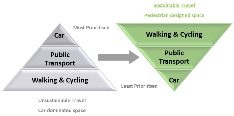
Figure 6.1: Existing & Desired Travel Type Hierarchies
Census 2016 data revealed that despite a large proportion of people living and working in the Carlow-Graiguecullen area, there remains a high dependency on private car usage for travel (which at 72%, was higher than the national average). The impact of expanding development on greenfield edge of centre sites is a key factor in this regard, which together with unconnected patterns of development, particularly in residential estates, emphasises the need to examine existing land use and transport provision to ensure the right infrastructure is in place to connect the population to key employment, service, educational, and recreational facilities.
Sustainable modes of transport are recognised as being a viable alternative to the private car where significant residential and employment opportunities exist. Provision of appropriate active travel infrastructure together with behavioural change will be key in this regard.
For further details on the existing transport characteristics of Carlow-Graiguecullen please refer to Chapter 2.
6.1 Integrated Land Use & Transport Planning
A key approach to support a shift towards sustainable, healthy, and low carbon urban areas is the formulation of land use policies which prioritise development that is within realistic walking and cycling distances from key employment, service, educational, and recreational areas. In this regard, Carlow, and Laois County Councils both acknowledge the importance of the fundamental link between land use and transport planning (ref: Fig 6.2) to reduce car-based travel and promote more sustainable and active modes travel.
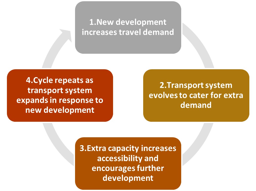
Figure 6.2: Landuse-transport feedback cycle
The importance of integrated land use and transport planning for the urban area is addressed in the Local Transport Plan (LTP) which accompanies this Draft JULAP and is also reflected in the findings of the 10-Minute Town Study commissioned by the Southern Regional Assembly in 2020 for Carlow Town. The findings point to deficiencies in the existing built environment with respect to accessibility, permeability, active travel, and public transport infrastructure.
Integrated Land Use and Transport Planning – Overarching Policy
It is the policy of Carlow County Council and Laois County Council to:
| LT. P1: | Actively support an integrated approach to land use and transport planning in Carlow-Graiguecullen that promotes a shift towards a sustainable, healthy, and low carbon joint urban area with a reduced need for car-based travel, and through the prioritisation of development that is within reasonable walking and cycling distances from key employment, service, educational, and recreational areas, and key public transport nodes. |
| LT. P2: | Ensure the design of all streets and roads in the joint urban area complies with the principles, approaches and standards in the Design Manual for Urban Roads and Streets (DMURS 2013-2019) and any subsequent updates to this Design Manual. |
6.2 Planning for Sustainable Travel and Transportation in Carlow-Graiguecullen
The achievement of a comprehensive and meaningful transition towards a model of sustainable travel and transportation in Carlow-Graiguecullen is a critical component to realise the future vision for the joint urban area. Sustainable integrated communities can only be achieved by providing communities with a realistic and convenient alternative to the private car which links key destinations in the joint urban area. Furthermore, without the delivery of sustainable travel options, other strategic development policy such as the successful regeneration of the town centre cannot be achieved. Accordingly, this JULAP will seek to maximise, where feasible and subject to funding, the opportunities identified in the ABTA (discussed in Section 6.3 below) and in Project Carlow 2040, capitalising on the space available in the joint urban area to create a transformed public realm, and expand high-quality pedestrian, cycling and public transport links.
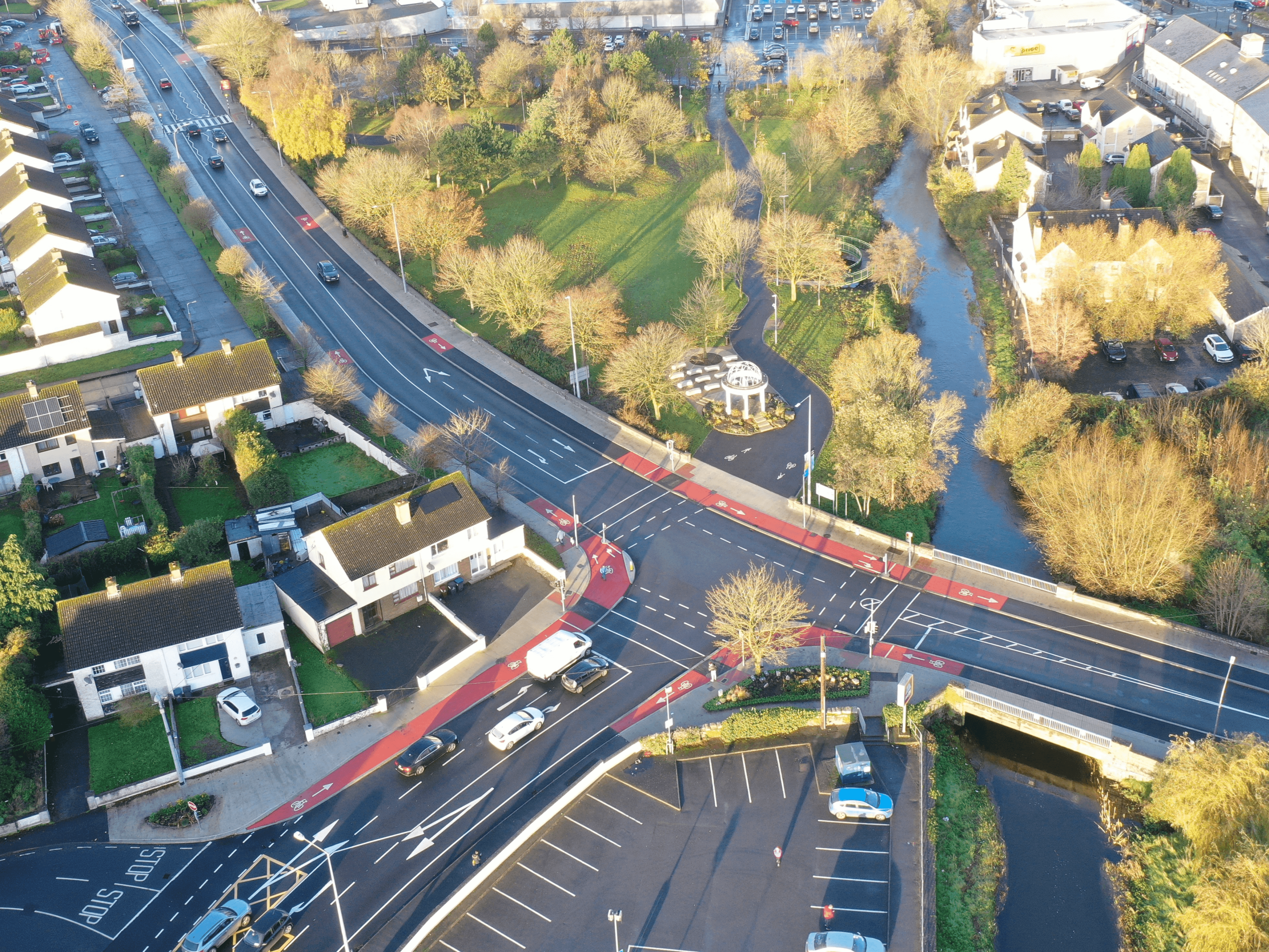
The importance of planning for sustainable travel is also reflected in the recent formation of new dedicated Active Travel Teams by Carlow County Council and Laois County Council. In conjunction with their respective Municipal District Offices and central Roads Departments, and in consultation with the NTA, the Active Travel Teams are involved in the design, procurement, supervision, and construction of schemes which include the provision of new walking and cycling routes, widened footpaths, and new pedestrian crossings.
Planning for Sustainable Travel and Transportation in Carlow-Graiguecullen – Policy
It is the policy of Carlow County Council and Laois County Council to:
| AT. P1: | Support the role of the Councils’ Active Travel Teams in the promotion and delivery of sustainable and active travel infrastructure and options in Carlow-Graiguecullen, including the provision of new and enhanced walking and cycling routes, widened footpaths, and pedestrian crossings. |
6.3 Local Transport Plan (LTP)
As part of the preparation of this JULAP a Local Transport Plan (LTP) has been undertaken on behalf of Carlow County Council and Laois County Council and in conjunction with the National Transport Authority (NTA). The LTP, included as Appendix IV, has assisted in placing sustainable transport considerations to the forefront of land use planning decisions in the formulation of the Draft JULAP. It examines existing and proposed transport infrastructure for all modes of transport, including walking and cycling, and provides some insight into existing transport patterns and constraints.
The outputs from the LTP for Carlow-Graiguecullen include a series of strategy options, with associated objectives, proposed interventions to support the shift towards sustainable movement throughout the joint urban area and to accommodate anticipated transport demand due to planned population growth. The key inputs in the development of the strategy options are shown in Figure 6.3. The strategy options in the LTP are outlined in Section 6.3.3.
The identification of transport infrastructure proposals in this JULAP and associated LTP, including locations and any associated mapping, that is not already permitted or provided for by existing plans/programmes/etc. is non-binding and indicative.
New transport infrastructure will be considered subject to environmental constraints, including those related to habitats and potential impacts (e.g. disturbance from lighting). This will include minimising river crossings, avoiding sensitive habitats, not increasing barriers to flood waters and sustainable design and construction techniques.
Proposals would need to be subject to a Corridor and Route Selection Process, as relevant and as per Section 5.9 “Infrastructural Improvement Process” of the Carlow County Development Plan 2022-2028 and Objective TRANS 15 of the Laois County Development Plan 2021-2027.
Proposed interventions will be required to demonstrate that they are consistent with all relevant legislative requirements.
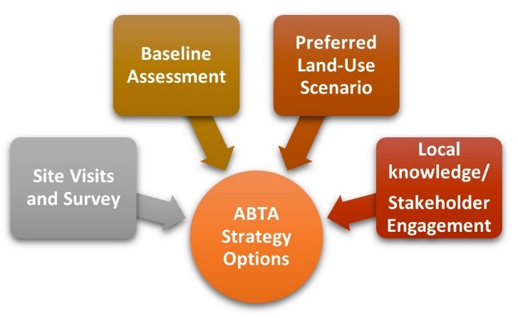
Figure 6.3: Key Inputs for LTP Strategy Options
Local Transport Plan (LTP) – Overarching Policy
It is the policy of Carlow County Council and Laois County Council to:
| LTP. P1: | Progress the delivery of the appropriate measures and interventions as outlined in the Carlow-Graiguecullen Local Transport Plan (LTP) on a phased basis and subject to the availability of funding, in order to support the shift towards sustainable travel and transport throughout the joint urban area and to accommodate anticipated transport demand due to planned population growth. |
6.3.1 Baseline Assessment
6.3.1.1 Existing Travel Demand
The baseline study carried out to inform the objectives of the LTP examined existing travel demand from POWSCAR analysis using Census 2016, data from Strava, permeability assessment, analysis of walking catchments, accessibility to opportunities and services together with public transport data including traffic growth, congestion, and parking provisions. The results of the study provide a comprehensive review of available data to identify the existing issues in the transport network serving the area, while also highlighting opportunities for improvement that can contribute to reduced car dependency. A summary of the baseline assessment as presented in the LTP is outlined in Table 6.1.
|
Table 6.1 LTP Baseline Data |
|
|
Modal Split |
|
|
Work Trips:
|
73% of the population travel to work in a private vehicle, as opposed to 13% using active modes (walking or cycling), and only 1.1% and 1.5% using bus and rail services respectively. |
| Education Trips: |
70% the main mode of transport to primary schools is the private vehicle, with 25% travelling by foot. The use of private vehicles for travel to secondary schools is 60%, with walking at 20%. 50% travel by private vehicle to SETU. The number of third level students walking is higher at 30%, but the use of public transport remains low. |
|
Origin -Destination Analysis |
|
|
Origin of Work Trips: |
Approx. 30% of work trips originate within the urban area. |
| Origin of Education Trips: | Over 65% of trips travelling to primary school originate in Carlow Town and 17.4% originate in Graiguecullen. |
| Destination of Work / Education Trips: |
At nearly 40%, the urban area is the largest origin point for secondary level school trips. 44.2% of work/college trips are internal to Co. Carlow. 60.6% of the Carlow primary school trips had a destination of Carlow. Following on from this, 15.2% and 13.6% of primary school trips originating in Carlow CSO were destined for Carlow, County Laois and Carlow Rural respectively. In terms of secondary level trips, 90% of residents attend a school that is located in the joint urban area. |
|
Transport Infrastructure and Services |
|
|
Walking and Running Trips:
|
Strava data indicates high usage of public roads for walking and cycling, and particularly along the N80 to the north and east of the joint urban area (including O’Brien Road, Cannery Road etc.), the R448 (including Dublin Road and Green Lane), and Carpenter Way (L4057). |
| Cycling Trips: | 2.1% of people in Carlow-Graiguecullen cycle to work, and similarly only 2% cycle to education. Strava details illustrate that cycling is focused along the N80 with higher levels of cycling along the roads to the south of the joint urban area, including the R448 (Kilkenny Road) which passes SETU Carlow. |
|
Permeability Assessment |
|
|
Linear Barriers to Permeability: |
Dublin-Waterford Railway Line: Six crossing points exist along this route on road network and with many lacking high-quality active travel infrastructures. N80: Crossing points are available along the N80 but many at roundabout junctions where vehicular traffic movements are prioritised. River Barrow: Three crossing points, two road bridges with footpaths and one pedestrian bridge open during the day-time hours at Carlow Town Park. Burren River: Three crossing points comprising road bridges with footpaths, with two bridges (at Hanover and Paupish) having segregated cycle facilities. |
|
Analysis of Walking Catchments |
|
|
Town Centre Catchment: |
Carlow District Hospital/St. Dympna’s, five primary level and two secondary level schools, as well as other key services, are all located within a 1km catchment. In addition, residential areas to the east and south are also within walking distance of the town centre. |
| Supermarket Catchments: | A 1km catchment reveals that the majority of residential areas fall within 1km of at least one supermarket. |
| Train Station Catchments: | The 1km catchment identified for Carlow Train Station reveals that it is easily accessible on foot from the core of the town centre but is not as accessible from more suburban residential areas. |
| Bus Stop Catchments: | A 500m catchment has been applied to bus stops. Only five bus stops are noted within the joint urban area. The town centre sits well within the 500m of buffer of bus stops, meaning catching the bus from and to town centre is viable. However, many residential areas and some other employment spots, like the business parks, are not close to a bus stop and aren’t as accessible on foot. |
| Primary and Secondary School Catchments: | The majority of the residential areas are all within a 1km walk of a primary school. Similar to primary schools, the 1km walking catchments shown for secondary schools in the LTP reveals that many residential areas fall within same. However, the trips to Tyndall College are very likely to be completed using the car due to fewer residential areas falling within the 1km catchment. |
| SETU: | The SETU Carlow campus is approximately a 15-minute walk from the town centre. However, like the other educational facilities, it is essential that this campus is served by sustainable transport options to ensure a modal shift is achieved. |
|
Accessibility to Opportunities and Services1 |
|
|
Employment: |
Overall, the results of the analysis demonstrate good accessibility to employment through walking and acknowledges the potential for encouraging increased active travel for commuting trips. |
| Primary and Secondary Schools: | Poorer accessibility to primary schools is evident for locations sited further away from the primary schools themselves. Lower accessibility patterns exist for Carlow Educate Together, which is likely due to inadequate active travel routes and permeability in that area. Overall, Census data for secondary schools reveals that many who live in the area could access secondary level education on foot and could use walking more frequently for travel. However, a large proportion of the population (just over 40%) have no secondary schools within a twenty-minute walk, therefore, without permeability improvements to shorten trip distances a modal-shift towards walking is unlikely to occur. |
| GP Services: | The analysis reveals that many residential areas to the northern and eastern ends of the joint urban area are not within a twenty-minute walk of many GP services due to their central town centre location. Equally however, travel from those residential areas in the immediate surrounds of the town centre is shown to be manageable on foot as they are within a twenty-minute walk of GP services. |
| Supermarkets: | The results show a large part of the joint urban area to be within a twenty-minute walk of at least one supermarket. It is also identified that there are pockets of lower walking accessibility to supermarkets in northern and eastern sections of the joint urban area, but generally walking access to these shops is good from most areas and an uptake in walking for these trips could be promoted. |
| Parks and Open Spaces: | Data analysis supports the improvement of park and open space accessibility based on the future proposed path network options. |
|
Public Transport |
|
|
Public Transport:
|
The LTP has highlighted various deficiencies in the current public transport offering in Carlow-Graiguecullen (e.g., while the joint urban area is well connected in terms of routes to neighbouring settlements, the frequency of connections could be improved, and there is potential to improve bus access along local routes). In addition to an overview of the public road network serving the joint urban area, the LTP examines available data for traffic growth, traffic congestion, and parking. It highlights that there is a high volume of car parking available in the town centre area, with approximately 62% calculated as being on-street pay and display parking, and a further 26% comprising off-street parking. This car parking provision, when coupled with a restricted sustainable transport network, reinforces the dominance of private cars as the preferred transport option. |
6.3.2 LTP Principles
Following consideration of the data presented in the baseline assessment, in addition to the completion of a SWOT analysis of the joint urban area, the LTP has outlined a series of guiding principles to help inform the option development process and as a future monitoring tool once implementation of the LTP begins. The guiding principles are outlined in Table 6.2 below.
|
Table 6.2: LTP Guiding Principles |
|
|
Overall Strategy Principles |
|
|
Walking Principles |
|
|
Cycling Principles |
|
|
Public Transport Principles |
|
|
Road Principles |
|
|
Parking Principles |
|
6.3.3 LTP Strategy Options
The analysis completed for the baseline assessment provided strategy options to address existing travel and transport issues. The implementation of the strategy options, including potential time frames for same are based on the following:
- Short-term: measure intended for implementation within 1-2 years
- Medium-term: measures intended for implementation within 3-5 years
- Long-term: measures intended for implementation within 6-10 years
- Ongoing: measure could commence in the short-term, but will span a number of years
The potential timeframes for each of the strategy options are set out in Section 5.3 of the LTP Report. These timeframes are indicative only and will be subject to funding and resource availability.
6.3.4 Active Travel Modes
The LTP provides walking and cycling strategies which have separate objectives and options.
6.3.4.1 Walking Strategy
The LTP walking strategy seeks to create convenient and efficient walking routes between homes and key trip attractors and reduce walking distances through enhanced permeability. This would give active modes of travel a competitive advantage over private cars. The strategy also seeks to facilitate recreational walking through the delivery of routes which are attractive.
The preferred option identified for the walking travel mode is an improved walking network, which delivers permeability enhancements. The proposed permeability connections are shown in Figure 6.4, and new or upgraded paths are shown in green. These permeability connections are recommended as a network.
The improved permeability connections where viable will be delivered as follows:
- Cut Throughs: removing a small permeability barrier where appropriate, such as fencing or a wall, to allow for the easy flow of pedestrians between two areas.
- New Paths: the provision of an entirely new connection, for example through a field or along the edge of residential estates.
The new permeability proposals include a new active travel bridge crossing the River Barrow. The provision of this bridge to the south of the joint urban area could remove a major permeability barrier and allow easier movement for pedestrians and cyclists, in an area currently severed by the River Barrow.

Figure 6.4: Proposed walking permeability connections shown in green
6.3.4.2 Cycling Strategy
The LTP cycling strategy seeks to provide a well-connected and high-quality cycle network across the joint urban area. Options have been developed building upon the existing cycle connections in Carlow and also to provide cycling connections between residential areas and key amenities. There are varying levels of cycle infrastructure proposed in the LTP, depending on the constraints that were encountered on each route.
Figure 6.5 outlines the cycle proposals incorporating a network of connected routes through different levels of infrastructure provision, including:
Off-Road Segregated: cyclists are segregated from pedestrians and road traffic, meaning each mode has their own designated space. This is the optimal level of infrastructure provision.
Shared Footway: cyclists and pedestrians share the footpath, which is indicated through markings on the pavement. This option does not allow for segregated space between all modes; however, it still ensures segregation between active modes and road traffic.
Shared Roadway (Quiet Route): cyclists and traffic share the road. In terms of the LTP option, shared roadway is only suggested for a quiet route, for example through a residential street which is quieter generally or where traffic calming measures (e.g. speed bumps or chicanes) are to be implemented.
Additional measures to complement the provision of the cycle network have also been identified in the LTP, including cycle parking, bike maintenance stands, cycle hire schemes, advertising, and cycle training.
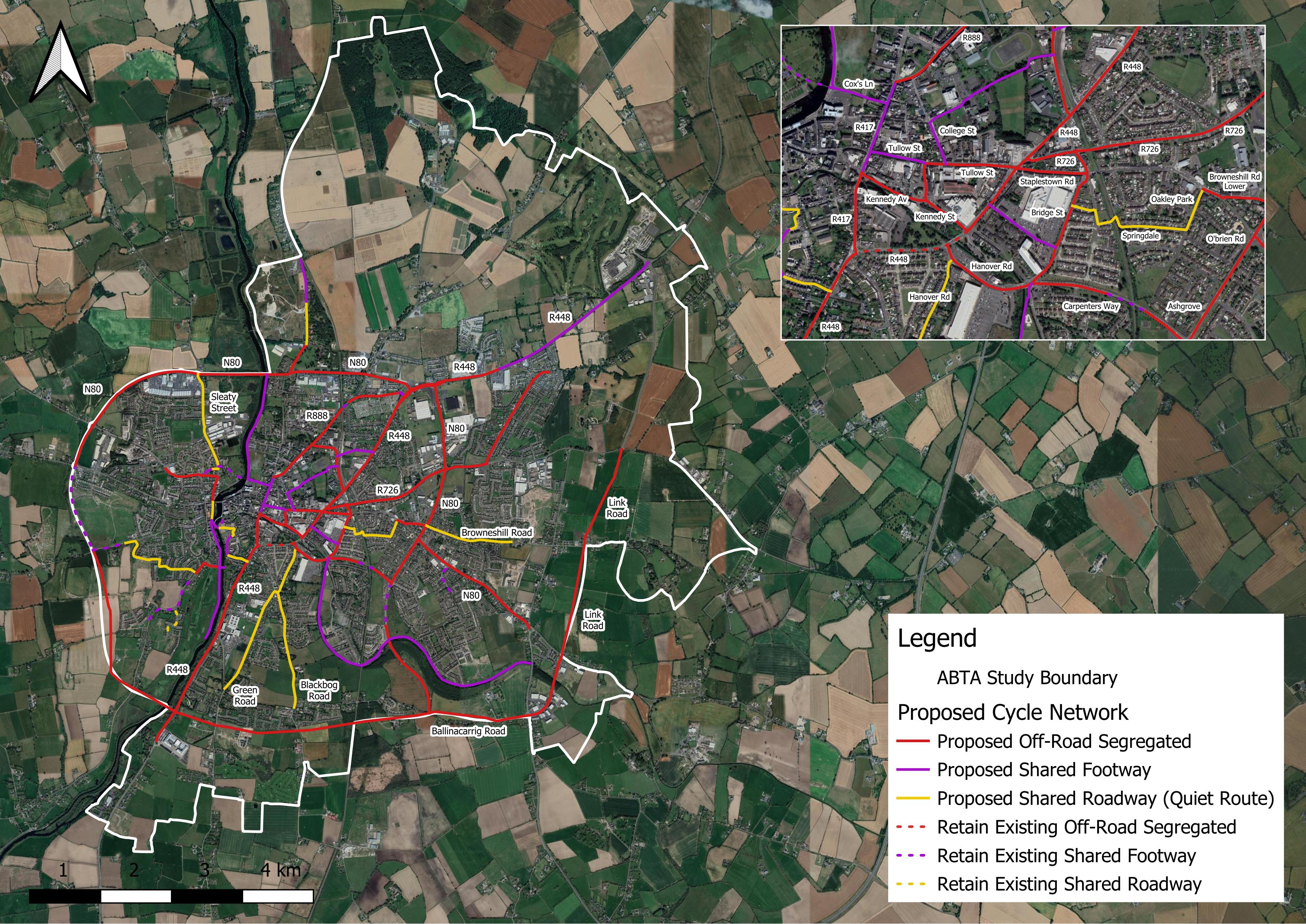
Figure 6.5: Proposed Cycling Network
Walking and Cycling – Policy
It is the policy of Carlow County Council and Laois County Council to:
| WC. P1: | Support and promote enhanced connectivity where appropriate for pedestrians and cyclists in Carlow-Graiguecullen in order to improve accessibility throughout the joint urban area and to the town centre, employment areas, residential areas, local schools and other educational facilities, recreational facilities, and public transport nodes. |
| WC. P2: | Ensure that all development where appropriate within Carlow-Graiguecullen provides for connectivity (pedestrian, cyclist and vehicular) to adjacent lands in accordance with the National Transport Authority’s Permeability Best Practice Guide (2015) and any subsequent update to this Guide. |
| WC. P3: | Ensure all new development proposals are permeable for walking and cycling and seek the retrospective implementation of walking and cycling connections and facilities in existing neighbourhood, where feasible and appropriate, in order to support and encourage a shift to sustainable travel modes. |
| WC. P4: | Ensure that pedestrian and cycling infrastructure is based on principles of Universal Design, and that all footpaths in Carlow-Graiguecullen are accessible to all members of the community, including people with disabilities, the elderly, and people with young children. |
| WC. P5: | Provide adequate and secure bicycle parking facilities subject to demand analysis at appropriate locations in the joint urban area. |
| WC. P6: | Develop and promote in conjunction with local communities and relevant stakeholders in the joint urban area, short walking routes such as looped walks, heritage trails and Slí na Sláinte routes. |
Walking and Cycling – Objectives
It is an objective of Carlow County Council and Laois County Council:
| W. O1: | Support and facilitate the delivery of new and improved walking and cycling network in Carlow-Graiguecullen, which delivers permeability enhancements and connections where appropriate as identified in the Local Transport Plan (LTP) and in Figures 6.4 and 6.5, in conjunction with the National Transport Authority, other statutory agencies, and relevant stakeholders. Final design details shall be subject to appropriate environmental assessment and undergo a separate public consultation process where applicable. |
6.3.5 Public Transport Strategy
The improvements to public transport identified in the LTP aim to make public transport travel more accessible, convenient, and attractive so that this mode can become a more viable transport option for Carlow-Graiguecullen.
6.3.5.1 Bus Strategy
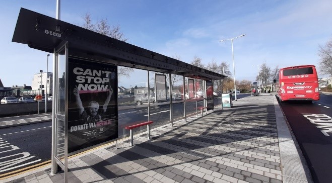
The bus strategy options seek to build upon the Carlow Town Bus Service. In particular, the strategy options in the LTP have been developed to cover routing gaps, bus stops and associated route infrastructure not provided for in the bus route plans developed by the NTA and Carlow County Council and Laois County Council i.e. improvements including shelters, lighting, better information, timetabling etc.). Such improvements will improve the overall attractiveness of public transport and could encourage increased usage. It is also proposed that major public transport stops such as Carlow Coach Park would become mobility hubs to act as a seamless transfer point for all transport modes as well as an enjoyable place to wait for public transport services, buy tickets and seek out information.
Carlow Bus Park Upgrade
Central to the LTP’s public transport strategy is the provision of an N80 orbital bus route, which would serve key destinations such as homes in Graiguecullen, retail spaces along the N80 and R448, Carlow Train Station, and MSD. The proposed N80 orbital route is shown in Figure 6.6.
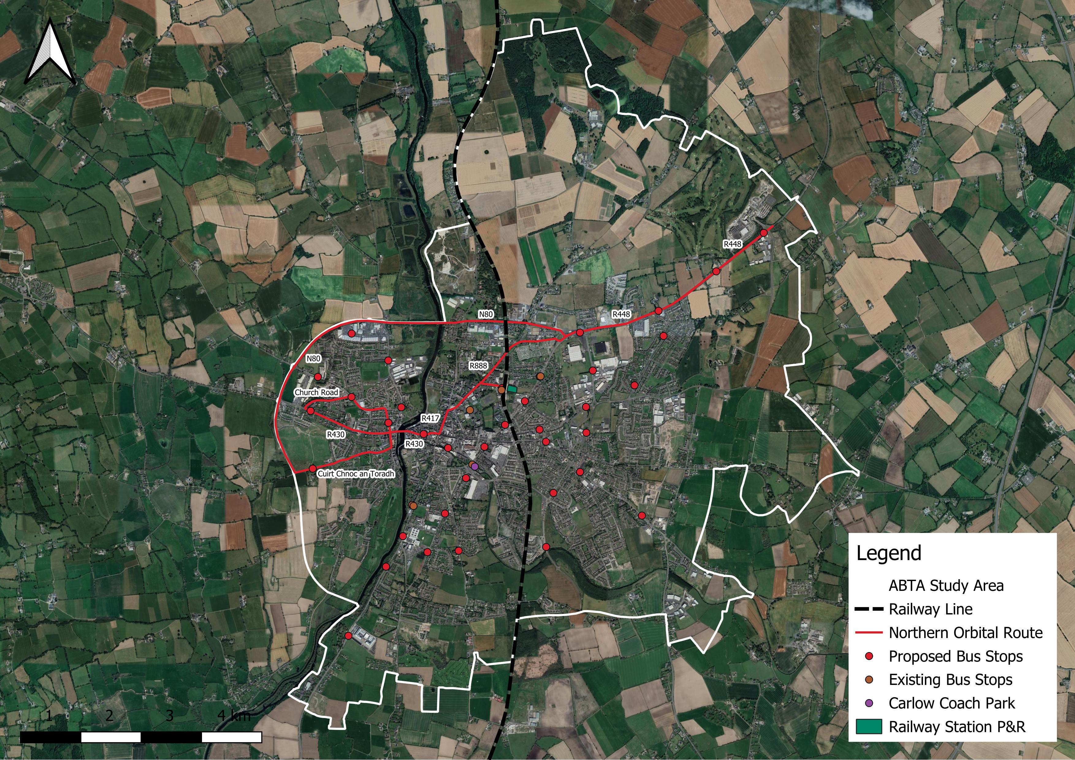
Figure 6.6: Proposed N80 Orbital Bus Route
6.3.5.2 Carlow Town Bus Service
Following a lengthy period of consultation between Carlow County Council, Laois County Council and the NTA, a local bus service became operative in August 2023. It comprises two bus routes as detailed in Figure 6.7 i.e., Route CW1 and Route CW2.
Both bus routes interchange at a number of locations, including Sandhills and Carlow Town Park, and the service operates 18 hours a day and seven days a week. The bus routes provide enhanced connections to and between services in the urban area, making trips more accessible and more sustainable.
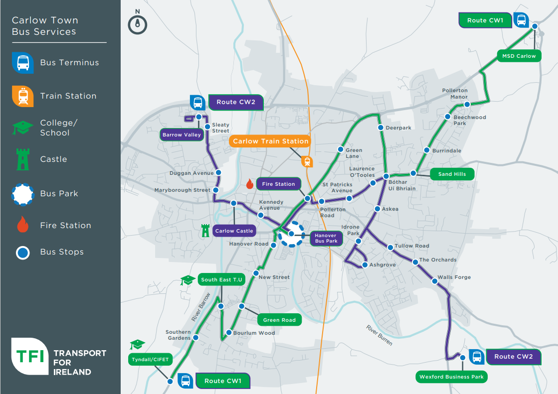
Figure 6.7: Bus Routes Route CW1 and Route CW2
6.3.5.3 Rail Strategy
The LTP acknowledges that improvements to the frequency of services at Carlow Railway Station would improve the attractiveness of rail as a mode of transport. While such improvements lie outside the scope of the LTP, Carlow County Council and Laois County Council will continue to engage with Irish Rail to support the development and delivery of more frequent and improved rail services to serve the joint urban area.
There is also recognition in the LTP that the provision of additional measures as outlined hereunder would further enhance the quality and attractiveness of public transport services:
- Real-time passenger information for bus services: Carlow County Council and Laois County Council will work with operators regarding the need for and benefits of real-time information.
- Flexible and affordable ticketing: Carlow County Council and Laois County Council will endeavour to work with the necessary parties to provide tickets for public transport services which are flexible and affordable.
- Marketing campaign: To improve the awareness of the public transport offer in Carlow-Graiguecullen, Carlow County Council and Laois County Council will run a marketing campaign. This would outline the improvements made to bus services and other key information e.g. prices, running times, and journey times between key destinations.
Public Transport – Policies
It is the policy of Carlow County Council and Laois County Council to:
| PT. P1: | Promote the sustainable development of Carlow-Graiguecullen by actively engaging with and supporting relevant national transport agencies in their remit to deliver improvements to the public transport network/services for the joint urban area, including at Carlow Railway Station and Carlow Bus Park, and to ensure the provision of integrated public transport services that provide an attractive and convenient alternative to private car travel thereby reducing car dependency for travel purposes. |
| PT. P2: | Support transport agencies, including the National Transport Authority (NTA) and public service transport providers in the provision of new and improved public transport services and routes, the enhancement of the quality, frequency and speed of existing train and bus public transport services serving Carlow-Graiguecullen, and with measures incorporated to facilitate access for all. |
| PT. P3: | Generate additional demand for public transport services in Carlow-Graiguecullen by maximising the accessibility of these services through integrated land use and transport planning. |
| PT. P4: | Ensure that public transport infrastructure, as required and appropriate, is considered as part of any significant residential or commercial development proposals in the joint urban area e.g., evaluation for requirement for new bus stops, turnaround facilities, pedestrian access, and layover facilities. |
Public Transport – Objectives
It is an objective of Carlow County Council and Laois County Council to:
| PT. O1: | Support and facilitate the delivery of the preferred public transport improvements identified in the Local Transport Plan (LTP) to make public transport travel in Carlow-Graiguecullen a more accessible, convenient, attractive, and viable transport option. |
| PT. O2: | Seek the delivery of a transport node in the immediate vicinity of Carlow Railway Station, facilitating integration of local bus services and private transport modes with the rail network which will facilitate easy exchange between modes and / or routes. |
6.3.6 Road Infrastructure Strategy
The LTP notes that due to the hierarchy of different transport modes, it would not be appropriate to make the case for significant road construction in isolation. Instead, future road construction, or improvements, are linked to improvements for sustainable transport as part of multi-modal solutions. Notwithstanding, the LTP recognises that given the character of the joint urban area and its rural hinterland, there remains a need for many people to use private vehicles for travel purposes, with the N80 providing a strategic connection for freight travel. Options have therefore been included within the LTP, which ensure the safe and efficient operation of the road network for the movement of people and goods.
Road strategy options in the LTP have been split into two categories, changes to the road layout or changes to junctions. In a number of locations, a subset of options is provided for, whereby a number of different measures could be implemented to achieve the same outcome. Whilst many of the options proposed in the LTP focus on the provision of active travel infrastructure, Carlow County Council and Laois County Council are committed to measures which will better manage the existing road network, such as the optimisation and control of traffic signals.
As some of the proposed measures reallocate road space to sustainable modes of transport, in the longer term, Carlow County Council and Laois County Council are seeking the construction of the Southern Relief Road in the respective County Development Plans. The Southern Relief Road will provide alternative routes for those that need to drive, removing traffic from the town centre and ensuring measures which reallocate road space to sustainable modes of transport are more feasible. Figure 6.8 denotes the location of potential changes to road and junctions in Carlow-Graiguecullen. For information on these potential changes the reference numbers shown in Figure 6.8 should be cross referenced with Table 3-1 in the LTP Report.
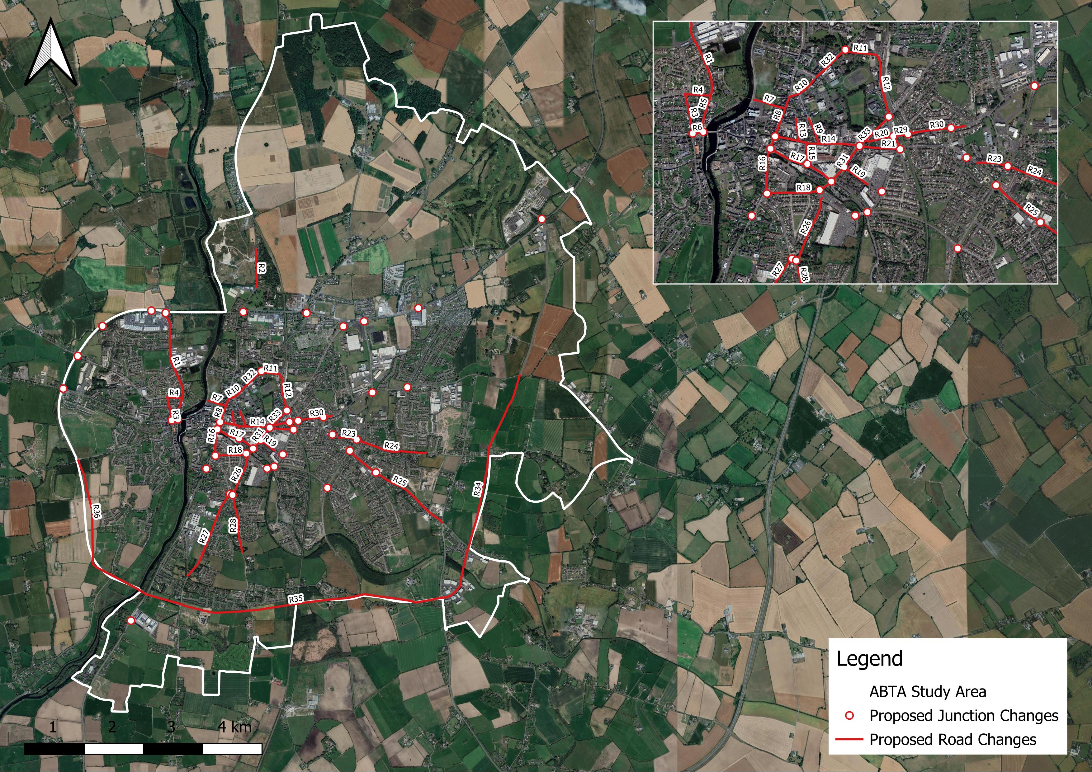
Figure 6.8: Proposed Road Change & Upgrades
6.3.6.1 Carlow Southern Relief Road
At a national level the delivery of the Carlow Southern Relief Road is identified in the National Development Plan 2021-2030 as a priority strategic project. At a regional level, the RSES for the Southern Region supports the delivery of the Southern Relief Road N80 – R448 and its completion to link with the N80 within County Laois, including the provision of an appropriate crossing of the River Barrow and other transport measures with adjoining local/ regional authorities and stakeholders (see RPO 14 v.). The RSES for the Eastern and Midlands Region also acknowledges the importance of inter-regional transport routes such as the N80.
The delivery of the Southern Relied Road is also an objective of the Carlow County Development Plan 2022-2028 (see Objective RR. O1). The Carlow Northern Relief Road Extension in County Laois, which forms part the overall Southern Relief Road route, is a priority road project in the Laois County Development Plan 2021-2027 (see Policy Objective Trans 25).
The completion of the Southern Relief Road is of strategic regional importance in terms of enhancing the connectivity between the Midlands Region and South-East Region. It is also of significance at a more local level in the joint urban area in terms of addressing and alleviating local traffic management considerations, with associated benefits for the urban environment and local economy. The delivery of the relief road also has the potential to have a positive impact on reducing optional vehicular trips in the town centre and overcoming road network pinch points. The three planned phases for the route are as follows:
- Phase 1: from the N80 at Ballinacarrig northwards to link with the Carlow Eastern Relief Road.
- Phase 2: from the Kilkenny Road (R448) to the N80, including a crossing over the Dublin-Waterford Railway Line.
- Phase 3: from the Carlow Northern Relief Road Extension southwards to the Kilkenny Road (R448) and including a crossing over the River Barrow.
The indicative alignment of the Southern Relief Road, including Northern Relief Road Extension, is illustrated in Figure 6.9. Carlow County Council and Laois County Council will continue to engage with the Department of Transport to support the delivery of the Southern Relief Road and Northern Relief Road Extension in accordance with the provisions of the National Development Plan, the RSES for the Southern Region, and the Carlow County Development Plan 2022-2028.
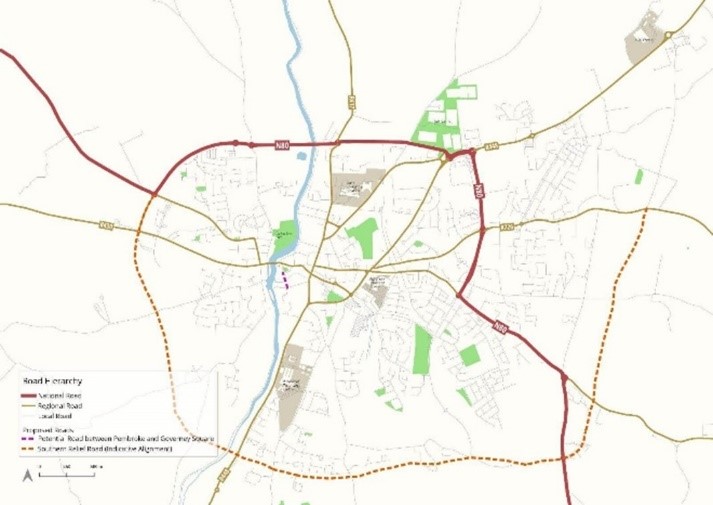
Figure 6.9: Indicative alignment of Southern Relief Road
Road Infrastructure – Policies
It is the policy of Carlow County Council and Laois County Council to:
| RI. P1: | Maintain, improve, and extend the public road network in and around Carlow-Graiguecullen to ensure a high standard of connectivity and safety for all road users. |
| RI. P2: | Co-operate and liaise with the Department of Transport, the National Transport Authority (NTA) and Transport Infrastructure Ireland (TII) in relation to securing appropriate improvements/ extensions as appropriate to the public road network within Carlow -Graiguecullen. |
| RI. P3: | Provide for traffic calming and speed reduction measures throughout the joint urban area, where necessary as funding allows, and ensure that all new developments are designed to incorporate appropriate traffic calming measures as set out in the Design Manual for Urban Roads and Streets (DMURS 2013-2017), and any subsequent updates to this Design Manual. |
| RI. P4 | That all medium to large scale and complex planning applications (30+ residential units, commercial development over 1,000sq.m., or other development proposals as required by Carlow County Council and Laois County Council) shall be accompanied by a Traffic Impact Assessment (TIA) carried out in accordance with Transport Infrastructure Ireland’s (TII) Traffic and Transport Assessment Guidelines (2014) and any subsequent updates this Guidelines. |
Road Infrastructure – Objectives
It is an objective of Carlow County Council and Laois County Council to:
| RI. O1: | Support and facilitate the delivery of the preferred road infrastructure improvements identified in the Local Transport Plan (LTP) and Figure 6.8, with associated benefits for sustainable travel and transport and multi-modal solutions. |
| RI. O2 | Support and facilitate the planning, design, and completion of the Carlow Southern Relief Road N80-R448 including a new bridge crossing over the River Barrow, to enhance connectivity between the South-East and Midlands Regions, and to address and alleviate traffic management considerations thereby making a positive contribution to the local economy and urban environment of Carlow-Graiguecullen. |
6.3.7 Parking Strategy
Options for parking are proposed in the LTP, and which in some cases would be necessary to provide improved infrastructure for other travel modes or an improved public realm / street environment in the joint urban area. The strategy options for parking are listed in Table 6.3.
Parking – Policies
It is the policy of Carlow County Council and Laois County Council to:
| PK. P1: | Support the provision of parking in Carlow-Graiguecullen to provide for the needs of residents, businesses, and visitors to the joint urban area. |
| PK. P2: | Apply the policies, objectives and standards for parking as set out in the Carlow County Development Plan 2022-2028 as applying the Carlow Town functional area in County Carlow and of the Laois County Development Plan 2021-2027 as applying to the Graiguecullen functional area in County Laois and relevant Section 28 Guidelines, in considering applications for planning permission in the joint urban area. |
| PK. P3: | Allow for the reduction in car parking requirements for commercial developments in suitable town centre locations within the joint urban area where a detailed parking analysis demonstrates adequate supply of proximate car parking spaces thereby encouraging a modal shift away from the private car to more sustainable forms of transport, walking, cycling and public transport. |
| PK. P4: | Apply flexibility in relation to car parking requirements where appropriate in response to well-designed development proposals that can achieve urban infill and brownfield development objectives in Carlow-Graiguecullen, and subject to the availability of connections to active travel and public transport infrastructure and provided public safety is not compromised and the environment is suitably protected. |
| PK. P5: | Promote and support the provision of appropriate infrastructure at suitable locations in the joint urban area to accommodate a change to electric vehicles, by requiring all new carparks or extensions to existing carparks to include the installation of electric vehicle charging points. |
Parking – Objective
It is an objective of Carlow County Council and Laois County Council to:
| PK. O1: | Support and facilitate the delivery of the preferred car parking options identified in the Area Based Transport Assessment (ABTA). |
|
TABLE 6.3: ABTA PARKING STRATEGY OPTIONS |
|
|
OPTION |
DESCRIPTION |
|
Parking Pricing |
Review pricing across town centre |
|
New Railway Station Car Park |
New car park east of the railway line accessed from Glendale Avenue |
|
Current Railway Station Car Park |
Convert the current railway station car park into a place for cycle parking, a drop-off zone for those trying to access the station, as well as an upgraded bus stop and waiting area |
|
Carlow Retail Park |
Make use of some of the spaces in the Carlow Retail Park to provide parking for SETU students and workers who could then walk to campus. |
|
School Drop-Off Restrictions |
Remove set down or drop-off zones immediately outside schools Resident permits on streets near to schools. |
|
Electric Vehicle Charging |
Provision of electric vehicle charging at convenient locations |
|
SETU |
Provide a new car park near to SETU |
|
Parking App |
Consider benefits of a parking app to make sure parking in Carlow can be easily located and paid for. |
|
Parking Enforcement |
Ensure adequate enforcement of parking restrictions to ensure benefits of the other parking options are captured. |
|
Vehicle Wayfinding |
Provision of signage which can identify where car parking is located and number of spaces available.
|
[1] ATOS (Accessibility to Opportunities and Services) is a tool maintained by the NTA to investigate how easy it is to access a range of different key services by active modes including Employment, Primary Education, Post Primary Education, GPs, Food Shopping and Open Spaces. Further details regarding the ATOS methodology can be found in Section 5.1.3 of the ABTA Part 1 - Baseline Assessment.
Contents
Observations
Observations
Pedestrian Crossings and Pedestrianizing parts of the town centre
I really welcomed the fact the the plan had a specific chapter on Active travel. Central Government plans and the Carlow County Council's plans are in agreement that we need to make a vast reduction...
Serious Safety Concerns regarding the proposed walk way through Kearneys Lane, Pollerton Big, Carlow.
Having read the Strategy, I have serious safety concerns in relation to proposed walking route through Kearneys Lane.
1. The Lane is a single lane, laneway which is extremely narrow and when...
Objection to walk through at the end of Kearney's lane. The reason for the objection is to inhibit anti social behaviour which was seen in the past . Hence the reason why the lane was closed. It is a quiet lane and would lend itself for undesirable activ
At no point where the residents consulted in making Kearney's Lane a walk through which is not acceptable.