In the first instance I hereby respectfully request that Carlow and Laois County Councils extend the deadline for submissions in respect of the Draft Carlow-Graiguecullen Joint Urban...
Chapter 1- Plan Review and Context
Closed13 Dec, 2023, 9:00am - 5 Feb, 2024, 5:00pm
1.1 Introduction
Carlow County Council and Laois County Council have worked collaboratively to prepare this Draft Carlow Graiguecullen Joint Urban Local Area Plan 2024-2030. The plan once adopted will replace the previously operative Joint Spatial Plan for the Greater Carlow Graiguecullen Urban Area 2012- 2018 (as extended).
This Draft Local Area Plan (LAP) addresses spatial planning in the Carlow-Graiguecullen area and identifies the various social, economic, and environmental issues of relevance. Policies, objectives, and related provisions are outlined to guide future development in accordance with the proper planning and sustainable development of the area.
1.2 Legislative Context
A mandatory Local Area Plan is required for Carlow Town having regard to Section 19 of the Planning and Development Act 2000 (as amended), which states that a Local Area Plan is required to be prepared in respect of an area that is:
- designated as a town in the most recent census;
- has a population in excess of 5,000; and,
- is situated in the functional area of the planning authority which is the county council.
Carlow-Graiguecullen is a designated Key Town with a recorded population in excess of 27,000 in 2022.
In accordance with Section 18(2) of the Act, Carlow County Council and Laois County Council are collaborating in the preparation of this Joint Local Area Plan.
1.3. Local Area Plan Process
The Local Area Plan process, including timescales, are illustrated in Fig. 1.1. The process involves consultation at three key stages with the public, prescribed bodies, and other stakeholders, as follows:
- Pre-Draft,
- Draft Plan, and
- Proposed Amendments.
Pre-draft public consultation, including the publication of an Issues Paper1, commenced in September 2022. The Issues Paper was placed on public display for a period of 4 weeks, both online and in hard copy at the offices of Carlow County Council, Carlow Central Library, and at the offices of Laois County Council, James Fintan Lalor Avenue, Portlaoise. Two public information sessions were also held in September and October 2022. Thirty-two submissions were received in total during the pre-draft consultation period. A Chief Executive’s Report summarising these submissions and outlining recommendations on the content of the Draft Urban LAP was prepared and issued to the Elected Members of both Local Authorities. Council Meetings were facilitated with the Elected Members of both Local Authorities to identify any strategic matters for inclusion in the Draft JULAP.
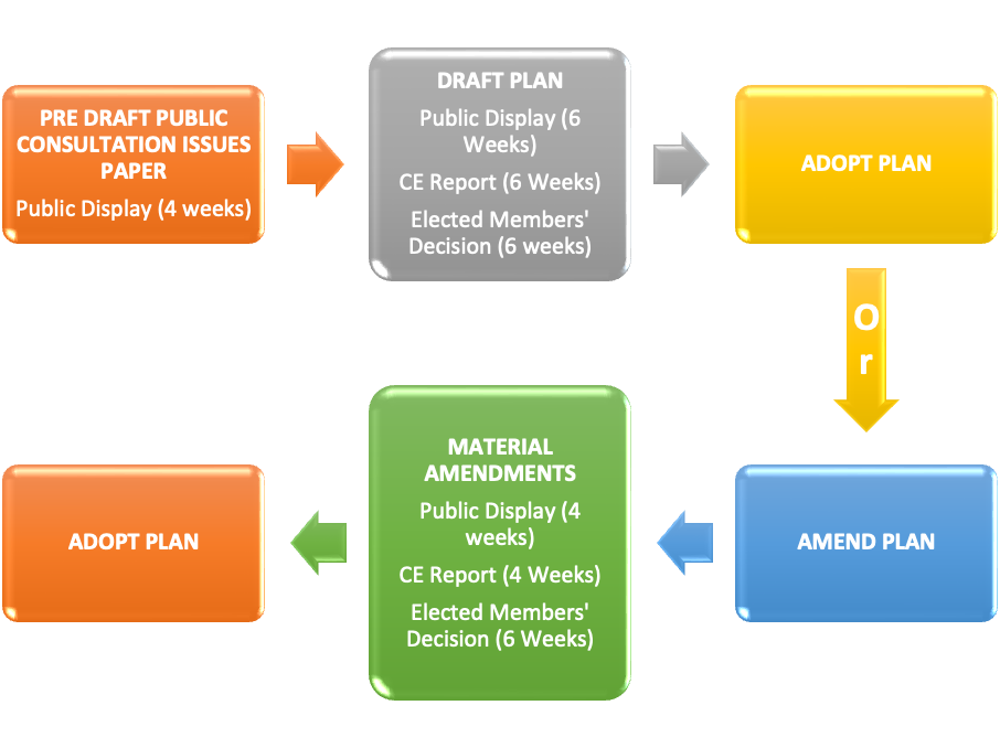
Fig. 1.1: Local Area Plan Process
1.4. Purpose of the Plan
The Draft Carlow-Graiguecullen Joint Urban Area Plan 2024-2030 (the ‘Draft JULAP’) is being prepared in accordance with the requirements and provisions of the Planning and Development Act 2000 (as amended), and in particular Sections 18 to 20 of this Act. The administrative boundaries of Carlow and Laois County Councils as applying to Carlow Town, Carlow Town Environs and Graiguecullen, are shown on Map 1.1.
The Draft JULAP sets out a coordinated strategy for the proper planning and sustainable development of Carlow Town, Carlow Town Environs, and Graiguecullen.
The Draft JULAP has been informed by:
- Project Ireland 2040 - National Planning Framework 2018 (NPF);
- Regional Spatial and Economic Strategy for the Southern Region 2020;
- Regional Spatial and Economic Strategy for the Eastern and Midlands Region 2019 (EMRA);
- Carlow County Development Plan 2022- 2028; and
- Laois County Development Plan 2021- 2027.
These policy documents are discussed in more detail in Chapter 2. The Draft JULAP has also been prepared with recognition of the role of climate action as a cross-cutting theme within the wider framework and role of spatial planning (See Chapter 11 Climate Action)
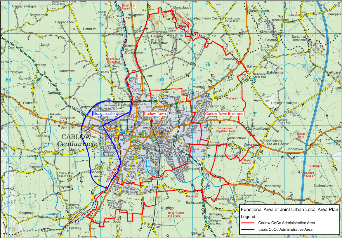
Map 1.1: Functional Areas of Carlow County Council and Laois County Council as applying to the development boundary of the JULAP
The Draft JULAP seeks to build on the previous successful collaboration of both Council’s in the preparation and adoption of the Joint Spatial Plan (JSP) for the Greater Carlow Graiguecullen Urban Area 2012-2018 (as extended). This collaborative approach acknowledges the unitary functioning of the joint urban area in terms of land use planning and the day-to-day activities of the local population, moving beyond a traditional focus on local authority county boundaries. This approach seeks to ensure that the future growth and development of Carlow- Graiguecullen is addressed in an integrated and coordinated manner, with strategic sites and regeneration areas to be delivered for the entirety of the urban area taking account of the compact growth and physical, economic, and social development requirements.
1.5 Life of the Plan
The Draft JULAP once adopted, and any subsequent amendments to same, will remain in force for a period of six years from the date of adoption or until it is reviewed, or another plan is made, and unless it is otherwise extended under Section 19 of the Planning and Development Act 2000 (as amended).
1.6 Form and Content of the Plan
The Draft JULAP comprises a written statement and combined land use zoning map encompassing Carlow Town, Carlow Town Environs, and Graiguecullen. The land use zonings for Carlow Town (i.e., former Carlow Town Council area), were adopted in May 2022 as part of the preparation of the Carlow County Development Plan 2022-2028 and have been reflected in this Draft JULAP.
The written statement and supporting maps comprise the primary policy document for the Draft JULAP and is set out over 12 Chapters.
|
Chapter 1 |
Plan Review and Context |
|
Chapter 2 |
Carlow-Graiguecullen Strategic Planning and Vision |
|
Chapter 3 |
Core Strategy and Housing |
|
Chapter 4 |
Economic Development, Retail and Tourism |
|
Chapter 5 |
Urban Design, Town Centre and Regeneration |
|
Chapter 6 |
Sustainable Travel and Transportation |
|
Chapter 7 |
Infrastructure and Environmental Services |
|
Chapter 8 |
Sustainable Communities |
|
Chapter 9 |
Built Heritage |
|
Chapter 10 |
Natural Heritage, Green Infrastructure and Landscape |
|
Chapter 11 |
Climate Action |
|
Chapter 12 |
Land Use Zoning Objectives and Implementation |
The Draft JULAP includes appendices and associated environmental reports i.e., Strategic Environmental Assessment (SEA), Appropriate Assessment (AA), and Strategic Flood Risk Assessment (SFRA). A Local Transport Plan (LTP) has also been prepared for the Urban Area. These documents complement and contribute to the evidence-led approach to the formulation of the written statement and supporting maps.
In the event of any conflict or ambiguity between what is contained within the Volume 1 Written Statement and the supporting maps, the Written Statement shall take precedence. In the full interpretation of all policies and objectives for Carlow-Graiguecullen, it is essential that both the Carlow and Laois County Development Plans, as overarching policy documents, are read in tandem with this Draft Plan. Where conflicting policies and objectives arise between these County Development Plans and the JULAP, the policies and objectives of the County Development Plans, as they apply to lands in the functional area of County Carlow or County Laois, shall take precedence. It is a specific provision of this JULAP to ensure that all of the provisions from the County Development Plans identified in the accompanying SEA Environmental Report and AA Natura Impact Report shall be complied with throughout the implementation of the Plan.
1.7 Environmental Assessments
Pursuant to requirements of the Planning Act and EU requirements this Draft JULAP is informed by the requirements for Strategic Environmental Assessment (SEA), Appropriate Assessment, and Strategic Flood Risk Assessment (SFRA).
1.7.1 Strategic Environmental Assessment (SEA)
Strategic Environmental Assessment (SEA) is the term which has been given to the environmental assessment of plans and programmes, which help determine the nature and location of individual projects taking place. It is a procedure that ensures that the environmental implications of decisions are considered before such decisions are made. SEA is a systematic process of predicting and evaluating the likely significant environmental effects of implementing a proposed plan or programme, in order to ensure that these effects are adequately addressed at the earliest stages of decision-making, in tandem with economic, social and other considerations. All plans and programmes to be adopted by Carlow County Council and Laois County Council shall comply with the requirements set out in the SEA Directive (Directive 2001/42/EC) and transposing Regulations.
The SEA process was integrated into the preparation of the JULAP, and the SEA Environmental Report is contained as a separate document accompanying the Plan (Refer to Appendix I).
1.7.2 Appropriate Assessment (AA)
In accordance with requirements under the EU Habitats Directive (43/92/EEC), the EU Birds Directive (79/409/EEC) and Section 177 of the Planning and Development (Amendment) Act 2010, the impacts of the policies and objectives of all statutory land use plans on certain sites designated for the protection of nature under European legislation, must be assessed as part of the preparation of the Draft JULAP. This process, known as Appropriate Assessment, is to determine whether or not the implementation of plan policies or objectives could have negative consequences for the habitats or species for which these sites are designated. Appropriate Assessment was undertaken as part of the plan-making process and a Natura Impact Report is contained as a separate document accompanying the Plan (Refer to Appendix II).
1.7.3 Strategic Flood Risk Assessment (SFRA)
The national Guidelines ‘The Planning System and Flood Risk Management’ (2009) state that Planning Authorities are required to introduce flood risk assessment as an integral and leading element of their statutory plan functions. A Strategic Flood Risk Assessment (SFRA) is an area-wide assessment of the existing risks of flooding and the impact of those risks arising from proposed spatial planning decisions. Plans must establish the flood risk assessment requirements for their functional area. The Guidelines further state that flood risk management should be integrated into spatial planning policies at all levels to enhance certainty and clarity in the overall planning process. In conjunction with the SEA process, Carlow County Council and Laois County Council carried out a SFRA of the JULAP. This SFRA is included in Appendix III.
1.8 Infrastructure Assessments
1.8.1 Infrastructure Assessment
Appendix 3 of the National Planning Framework (NPF) sets out a methodology for a two-tiered approach for the zoning of land which is informed by an Infrastructural Assessment, and states that ‘The potential for delivery of the required services and/or capacity to support new development must be identified and specific details provided by the Planning Authority at the time of publication of both the draft and final development or local area plan’.
The NPF places an emphasis on the need for compact, smart and sustainable growth and requires 30% of all new housing to be within existing urban footprints (outside of the five cities), thus reducing the amount of greenfield land required to meet future housing requirements.
The NPF defines Tier 1 and 2 lands as follows;
- ‘Tier 1: Serviced Zoned Land, comprising lands that are able to connect to existing development services for which there is service capacity available and can therefore accommodate new development; and
- Tier 2: Serviceable Zoned Land, comprising lands that are not currently sufficiently serviced to support new development but have the potential to become fully serviced within the life of the plan.’
The NPF requires that where lands are identified as Tier 2 lands, the potential for delivery of the required services and/or capacity to support new development must be identified and specific details provided by the Planning Authority at the time of publication of the draft and final local area plan. The Infrastructure Assessment is included as Appendix V. See also Chapters 6 and 7.
1.8.2 Local Transport Plan
As part of the requirement for an evidence-based approach to planning, as set out in the National Planning Framework (NPF) and the Regional Spatial and Economic Strategies (RSES) for the Southern Region and the Eastern and Midland Region, a Local Transport Plan (LTP) has been prepared to inform the drafting of the JULAP. The purpose of the LTP is to place the integration of land use and transport planning at the centre of the plan-making process for Carlow-Graiguecullen. The assessment examined the existing and proposed transport infrastructure and service provision across all modes of transport including sustainable means such as active travel modes (walking and cycling) in the joint urban area. The assessment provides an understanding of the existing constraints and modal share, and also identifies the proposed interventions within the plan area and in the wider context in order to facilitate a shift towards more sustainable travel and transportation options. The LTP is contained in Appendix IV and also forms the basis of the policies, objectives and related provisions included in Chapter 6.
https://consult.carlow.ie/en/consultation/carlow-graiguecullen-joint-urban-local-area-plan-2023-2029 and https://consult.laois.ie/en/consultation/carlow-graiguecullen-joint-urban-local-area-plan-2023-2029
Contents
Observations
Observations