Chapter 10 - Natural Heritage Green Infrastructure & Landscape
Aim: To protect and enhance the natural heritage and landscape of Carlow-Graiguecullen, thereby ensuring it makes a significant and positive contribution to biodiversity and the public realm, to the health, well-being, and recreational needs of residents, and to the role of green infrastructure as a natural asset capable of strengthening climate resilience in the joint urban area.
10.0 Introduction
Natural heritage applies to all elements of the natural environment, including native plants and animals and the landscapes and habitats they occupy. These elements of the natural environment are also commonly referred to as biodiversity, a separate term which gives recognition to the variety of living things in a particular habitat or landscape, and to the inter-connectivity and interdependencies that can exist between them. Conserving and enhancing natural heritage and biodiversity is an integral part of good environmental management and sustainable development.
Although an urban settlement, Carlow-Graiguecullen supports significant natural heritage spaces and corridors, some valuable examples of which include the River Barrow, the Burren River, Oak Park Forest Park, and Carlow Town Park. Protecting and enhancing this natural heritage can make a significant contribution to the health and well-being of residents in the joint urban area, at the same time as providing opportunities for economic growth, tourism, and recreation. Equally, the interconnected network of natural heritage features in the joint urban area, as a form of green infrastructure, can deliver a range of key ecosystem services that can contribute towards the protection of biodiversity, sustainable urban drainage, flood management, and climate action.
Further details on natural heritage, green infrastructure and landscape can be found in Chapters 9 and 10 of the Carlow County Development Plan 2022-2028, and in Chapter 11 of the Laois County Development Plan 2021-2027.
10.1 Designated Sites
Carlow-Graiguecullen boasts two significant natural heritage sites which contribute greatly to the character of the joint urban area. These sites comprise the River Barrow, a Special Area of Conservation (SAC), and Oak Park, a proposed Natural Heritage Area (pNHA).
10.1.1 River Barrow SAC
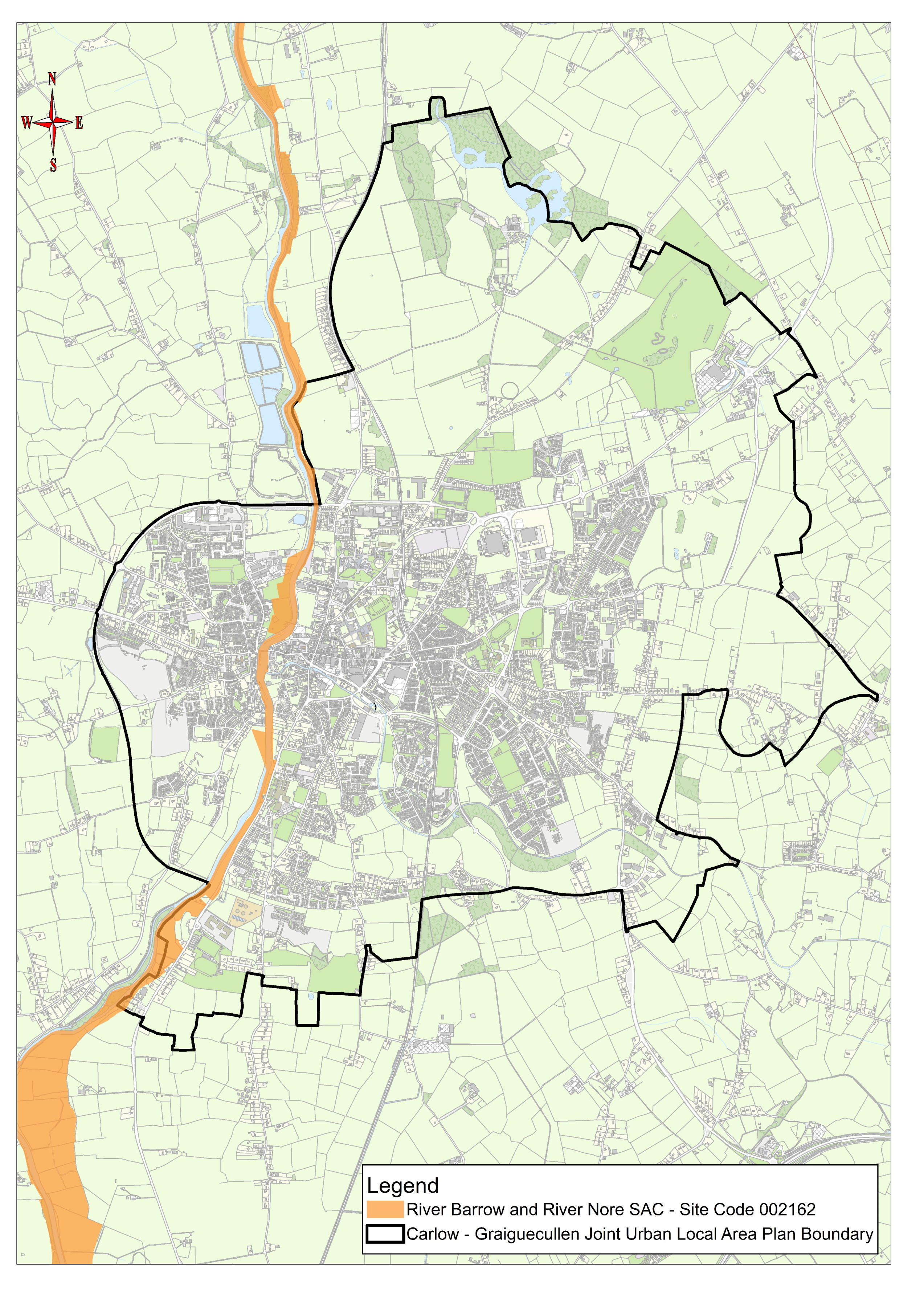
Special Areas of Conservation (SACs), also known as ‘European Sites’, are legally protected under the EU Habitats Directive (92/42/EEC) and are selected for the conservation of Annex I habitats and Annex II species. All such designated areas, including SACs, collectively form part of what is known as the Natura 2000 network of sites across Europe. The River Barrow forms part of the River Barrow and River Nore SAC (Site Code: 002162) and flows southwards through the joint urban area where it forms a natural boundary between lands at Carlow Town to the east and lands at Graiguecullen to the west. The SAC is of considerable conservation significance due to the occurrence of good examples of habitats and plant and animal species listed in Annexes I and II of the EU Habitats Directive. The populations of bird species that use the river corridor also contributes to its high conservation significance.
The spatial extent of the River Barrow SAC is shown on Map 10.1.
10.1.2 Oak Park pNHA
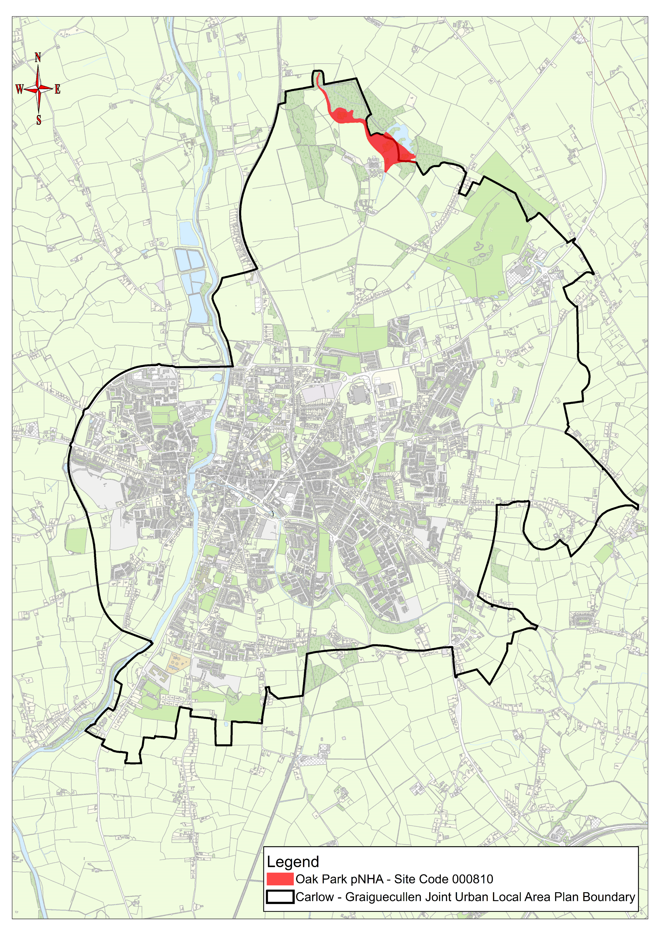
Natural Heritage Areas (NHAs) are designated sites of national importance for habitats, species, and for geological interest. Under the Wildlife Act 1976 (as amended), NHAs are legally protected from damage from the date they are formally proposed for designation. Sites that have been identified but not yet formally designated as NHAs, are known as proposed Natural Heritage Areas (pNHAs). The Oak Park pNHA is located at the northern end of the joint urban area and comprises mature woodland, lakes and wetlands that provide an important habitat for wildlife, including many wild and game birds.
The spatial extent of the Oak Park pNHA is shown on Map 10.2.
Natural Heritage – Policies
It is the policy of Carlow County Council and Laois County Council to:
| NH. P1: |
Protect, manage, and enhance the natural heritage, biodiversity, landscape, and environment of Carlow-Graiguecullen in recognition of its importance as a non-renewable resource, a unique identifier, as a natural resource, an ecosystem services asset that can contribute towards sustainable urban drainage, flood management, and climate action. |
| NH. P2: | Support the conservation and enhancement of the River Barrow and River Nore SAC, and to protect the SAC from any plans and projects that are likely to have a significant effect on the coherence or integrity of the designated site, in accordance with relevant EU environmental directives and applicable national legislation, policies, plans and guidelines. |
| NH. P3: | Ensure that Appropriate Assessment Screening, and if required Appropriate Assessment, is carried out in respect of plans and projects in Carlow-Graiguecullen. Where likely significant effects have been identified in respect of any plan or project not directly connected with or necessary to the management of European Sites, in particular the River Barrow and River Nore SAC, either individually or in combination with other plans or projects, ensure Appropriate Assessment in accordance with Article 6(3) of the EU Habitats Directive. Carlow County Council and Laois County Council shall only agree to the plan or project after having ascertained that it will not adversely affect the integrity of any European Site, in particular the River Barrow and River Nore SAC, unless the plan or project is subject to the provisions of Article 6(4) of the Habitats Directive. |
| NH. P4: | Contribute towards the protection, from significant adverse effects, of the ecological integrity, and the visual, recreational, environmental and amenity value of the Oak Park proposed Natural Heritage Area (pNHA) and associated habitats. |
| NH. P5: | Promote the carrying out of ecological/habitat assessments to inform the layout and design of development proposals and ensure they integrate the protection and enhancement of biodiversity and landscape features wherever possible in Carlow-Graiguecullen, by minimising adverse impacts on existing habitats (whether designated or not) and by including mitigation and/or compensation measures, as appropriate. |
| NH. P6: | Promote increased understanding and awareness of the natural heritage and biodiversity located in the joint urban area of Carlow-Graiguecullen. |
| NH. P7: |
Promote development for recreation and educational purposes that does not conflict with maintaining the favourable conservation status of the River Barrow and River Nore SAC and Oak Park pNHA, including the achievement of their conservation objectives. |
| NH. P8: | Promote, protect, and enhance sustainable and appropriate access to natural heritage in Carlow-Graiguecullen. |
| NH. P9: | Identify, protect, conserve, and enhance wherever possible, wildlife habitats and species of local importance in Carlow-Graiguecullen, not otherwise protected by legislation. Such habitats can include woodland, river, wetlands, and grassland areas along with field boundaries (hedgerows, stone walls and ditches). These features form part of a network of habitats and corridors, which allow wildlife to exist and flourish and contribute to compliance with Article 10 of the Habitats Directive |
| NH. P10: | Protect and enhance the natural environment of Carlow-Graiguecullen and recognise the important role of the natural heritage in the area through its diversity, quality, and integrity, and in terms of enhancing the image of the joint urban area and contributing to quality of life and wellbeing, economic growth, tourism and recreation. |
| NH. P11: | Ensure that lighting proposals along water courses, rivers, and streams in the joint urban area, are not in conflict with bat species, and to ensure that expert advice is sought on such lighting proposals in order to mitigate the impacts of lighting on bats and other species and habitats. |
Map 10.1: River Barrow and River Nore SAC
Map 10.2: Oak Park proposed Natural Heritage Area
10.2 Green Infrastructure
In a broad sense Green Infrastructure is a term used to group and describe those elements of the natural environment which can deliver eco-system services and protect natural heritage. The growing use of the term green infrastructure has placed a particular focus on the multi-functional role of the natural environment, which can when of a high quality simultaneously support wildlife corridors, sustain air and water quality, contribute to sustainable drainage, flood protection and climate resilience, and provide vital amenity and recreational spaces for communities. In this regard, it is equally important to note that not all elements of green infrastructure perform the same functions and not all are of equal value. For example, while a narrow and grassed strip of land adjoining a public road in the joint urban area may accommodate excess surface water runoff, it will not provide a significant wildlife habitat. Conversely, riparian habitat along the River Barrow would have greater capacity to absorb excess water, provide pollution control and would support a greater diversity of wildlife. Therefore, any development proposal that includes green infrastructure, must recognise such differences in quality and value and distinguish what are the most important components.
10.2.1 Green Infrastructure in Carlow-Graiguecullen
The green infrastructure network in Carlow-Graiguecullen provides connectivity of habitat for a range of species. Of particular importance to biodiversity in the joint urban area are:
- River Barrow and associated riparian habitat (Special Area of Conservation)
- Burren River and associated riparian habitat (tributary of the River Barrow)
- Oak Park Forest Park (proposed Natural Heritage Area)
Aside from the foregoing, the green infrastructure network in the joint urban area includes areas of woodland, public open/amenity spaces, parklands, gardens, hedgerows, and treelines. There are some areas of undeveloped ground, cemeteries, and agricultural fields which can warrant consideration. Recognition must also be given to existing and/or potential green infrastructure proximate to JULAP boundary, such as the former Sugar Factory lagoons along the western side of the River Barrow. It is critical that all of these areas are safeguarded and given the opportunity to increase their extent and ecological function for Carlow-Graiguecullen by retaining links and supporting connectivity within the network.
The roads and railway traversing the joint urban area also represent opportunities to connect green spaces and strengthen existing green infrastructure. In addition, the stepping stone habitats, including scattered trees, hedgerows, and parkland, as well as public open spaces within housing estates, can further enhance the connectivity of habitats, and in turn, promote biodiversity across the joint urban area. The network of existing green infrastructure in Carlow-Graiguecullen is shown on Map 10.3. Typologies of green infrastructure in the joint urban area are detailed in Table 10.1.
|
Table 10.1: Typologies of Green Infrastructure in Carlow-Graiguecullen |
|
|
Typology |
Examples |
|
Parklands & woodlands |
Woodland and parkland areas, including the trees, hedgerows, and grasslands within them, have a key role in supporting biodiversity in the joint urban area, and in improving the health and wellbeing of residents as recreation and amenity spaces. Some notable examples include Oak Park Forest Park, Carlow Town Park, Hanover Park, and Burren River Linear Park. |
|
Open spaces |
The network of open spaces located in Carlow-Graiguecullen, including those more easily identifiable along the River Barrow and Burren River, those more formally managed planted spaces in residential areas and on institutional lands, allotments, playing pitches, and gardens such as Delta Sensory Gardens and Gairdín Beo, function as the stepping stone and corridor habitats that support and promote biodiversity across the built environment. Other and in some case less noteworthy open areas scattered throughout the joint urban area (publicly accessible and otherwise) also as function green infrastructure.
This JULAP also recognises that burial grounds, while providing culturally sensitive space for burial and remembrance, have a significant value as recreational spaces similar to parklands for nature conservation and the promotion of diversity. Burial grounds in the joint urban area such as St. Mary’s Cemetery, Killeshin Church of Ireland Cemetery, and Barrow Track Cemetery (The Old Graves), are therefore considered a type of green infrastructure. |
|
Rivers/water bodies |
The River Barrow and the Burren River comprise significant water bodies in the joint urban area, and along with lakes and wetlands at Oak Park, provide a multitude of benefits including biodiversity, flood management, and recreation and amenity space. The location of agricultural lands on the flood plains of the River Barrow are also of relevance in this regard.
|
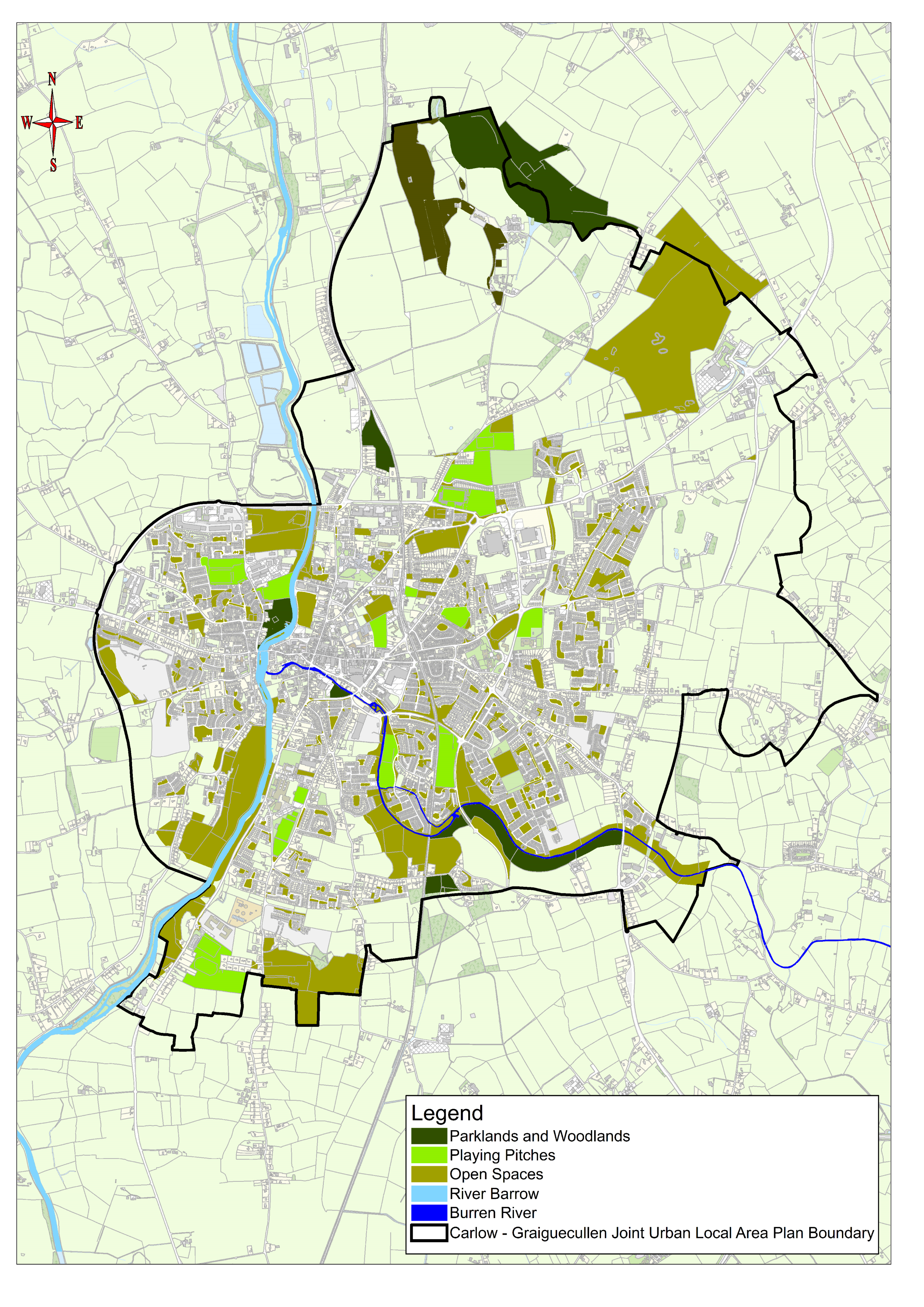
Map 10.3: Network of Existing Green Infrastructure in Carlow-Graiguecullen
10.2.2 Carlow Town Biodiversity Strategy and Action Plan 2021-2025
This Biodiversity Strategy and Action Plan was prepared under a partnership framework between Carlow County Council, Carlow Town Development Forum, and the community of Carlow Town. It recognises the potential in Carlow Town to strengthen the green infrastructure network and promote habitat connectivity to the surrounding landscape through the implementation of a range of biodiversity enhancement measures, with a focus on five areas as detailed below. The Biodiversity Strategy and Action Plan provides a strategic plan and specific actions for protecting and enhancing biodiversity in each of the focus areas, including tackling invasive non-native species and protecting ecosystem services. The Strategy also fully acknowledges the economic value of ecosystem services and the need to restore them for the benefit of the local economy and the wellbeing of residents.
1. Town Centre
Carlow Town Centre predominantly contains buildings and artificial surfaces habitat. This habitat type includes roads, houses, buildings, and other artificial built and hard surfaces. There are trees planted under pavements throughout the town, particularly along Kennedy Avenue, Barrack Street and new trees planted along Green Lane. It is typically of low botanic value, however, may be of value for fauna species, in particular bats, swallows and swifts.
2. Hanover Park
Hanover Park is a public park that contains a variety of different habitat types, including amenity grassland that makes up the majority of the park area, scattered trees and parkland, ornamental/non-native shrub along part of the bank of the Burren River and depositing/ lowland rivers i.e., the Burren River that forms a boundary to the north of the park.
3. Burren River Linear Park
The Burren River Linear Park consists of a walking/cycling route alongside the Burren River. Five main habitat types exist along the portion of the trail surveyed, including amenity grassland, a mosaic of treelines and scrub, depositing lowland rivers, a small section of buildings and artificial surfaces, and dry meadows and grassy verges.
4. River Barrow
The River Barrow was included as a focus area due to it being the most important ecological feature in the area and a designated Special Area of Conservation with legal protection for habitats and species of European importance (See Section 10.1.1 for further details regarding the SAC).
5. The Plots
The Plots are situated in a residential area. They consist of the following habitat types: amenity grassland (Hanover Harps Playing Pitches), treelines, scattered trees and parkland, horticultural land; recolonising bare ground; dry meadows and grassy verges; hedgerows, buildings and artificial surfaces and flower beds and borders.
Green Infrastructure – Policies
It is the policy of Carlow County Council and Laois County Council to:
| GI. P1: | Protect and enhance the biodiversity and ecological function of the green infrastructure network in Carlow-Graiguecullen. |
| GI. P2: | Identify, protect, maintain, and enhance existing and planned green infrastructure assets in Carlow-Graiguecullen, and recognise the wide range of environmental, social, and economic benefits of green spaces and nature-based solutions by ensuring the integration of green infrastructure planning and development in the planning process. |
| GI. P3: |
Protect and preserve landscape features which significantly contribute to green infrastructure in Carlow-Graiguecullen, including trees, hedgerows, woodlands, wetlands, watercourses, and other habitats. |
| GI. P4: | Require the protection and integration of new and existing green infrastructure as an essential component of all new developments in Carlow-Graiguecullen, and to ensure future development does not fragment, damage, or prejudice the integrity of the green infrastructure network in the joint urban area. |
| GI. P5: | Ensure the green infrastructure and habitat features identified on Map 10.3, Network of Existing Green Infrastructure in Carlow-Graiguecullen, and the linkages between them and surrounding rural areas, are integrated into the design of new developments as far as practicable. |
| GI. P6: | Require development proposals to include an outline of measures to protect the retained green infrastructure of a site during the period of construction. |
| GI. P7: | Require large scale development proposals in the joint urban area such as residential schemes, industrial development, or retail schemes, to submit a green infrastructure plan as an integral part of a planning application. |
| GI. P8: | Promote a network of pedestrian and cycle paths to enhance accessibility to the green infrastructure network in Carlow-Graiguecullen, while ensuring that the layout, design, and operation of the routes responds to the ecological protection needs of each site. |
| GI. P9: | Incorporate elements of green infrastructure into existing areas of hard infrastructure in the joint urban area, where possible, thereby integrating these areas of the existing urban environment into the overall green infrastructure network. |
| GI. P10: | Promote appropriate tree planting and pollinator friendly planting, in accordance with the recommendations of the All-Ireland Pollinator Plan 2021-2025 throughout Carlow-Graiguecullen and in open spaces within new developments, in order to enhance local biodiversity, visual amenity and surface water management. |
| GI. P11: | Ensure that green areas and open spaces associated with new residential developments and other relevant projects provide multifunctional benefits that enrich quality of life for local communities, ecologically rich areas that enhance biodiversity, and sustainable water management. |
| GI. P12: | Take account of Inland Fisheries guidance ‘Planning for Watercourses in the Urban Environment, A Guide to the Protection of Watercourses through the use of Buffer Zones, Sustainable Drainage Systems, Instream Rehabilitation, Climate/Flood Risk and Recreational Planning’ (2020) when considering development proposals in the vicinity of rivers and streams in Carlow-Graiguecullen. |
| GI. P13: | Incorporate items of historical or heritage importance within the green infrastructure network in Carlow-Graiguecullen as amenity features, as far as practicable. |
| GI. P14: | Seek to protect trees and hedgerows in the joint urban area with a particular local amenity or conservation value and encourage the planting of native tree and hedgerow species. |
Green Infrastructure - Objectives
It is an objective of Carlow County Council and Laois County Council to:
| GI. O1: | Support the implementation of the Carlow Town Biodiversity Strategy and Action Plan 2021-2025, and any subsequent updated version this document. |
| GI. O2: | Investigate the feasibility of providing a wetland amenity area on lands comprising the former Sugar Factory lagoons, in conjunction with relevant stakeholders and local community groups, taking account of the environmental sensitivities of the land and the need to ensure impacts to biodiversity and nature conservation interests are avoided. |
10.3 Green Infrastructure and Sustainable Urban Drainage Systems (SuDS)
The impact of extreme rainfall events is increasing with climate change and this is significantly increasing both the level of pollution from urban runoff and the flood risk arising from the greater volume of that runoff from the largely impermeable urban area.
A fundamental part of SuDS is the provision of adequate levels of treatment of surface water prior to discharging to a watercourse. SuDS aims to address both quality and quantity of runoff whereby both the rate and volume of discharge are reduced.
This JULAP encourages new developments to consider nature-based solutions to the management of rainwater and surface water runoff to reduce pollution and reduce flood risk as well as to improve biodiversity and provide a greener more pleasant urban environment.
Developers are advised to consult with the Nature-based Solutions to the ‘Management of Rainwater and Surface Water Runoff in Urban Areas – Water Sensitive Urban Design Best Practice Interim Guidance Document’ (DHLGH, 2021) which seeks to mimic the natural water balance of rural areas through water sensitive urban design. This can be achieved through the replacement of impermeable surfacing with nature-based planted areas that are designed to absorb, retain, store, and treat urban runoff prior to discharge back into the environment.
Further details regarding SuDS can be found in Section 7.3, Chapter 7 Infrastructure and Environmental Services.
10.4 Landscape
Our tangible heritage includes our visible natural landscape with its rich diversity of habitats and species. In the context of an urban settlement such as Carlow-Graiguecullen, this natural heritage, such as the River Barrow and Burren River, is very much interwoven with the historic evolution of the built environment of the joint urban area, including its streetscapes, bridges, its architecture, and its archaeology. The challenge is to manage the varied and inter-linking elements of our landscape resource in a sustainable manner, so that we can protect our heritage assets while promoting a quality of life, and a sense of identity and pride in the joint urban area.
In recognition and support of the aforesaid, a number of distinct Landscape Character Types (LCTs) have been designated within Carlow-Graiguecullen. These LCTs are shown on Map 10.4 and were prepared with regard to the DEHLG ‘Draft Landscape and Landscape Assessment Guidelines for Planning Authorities’ (2000). There is a total of 6 no. LCTs in the joint urban area as set out below, each of which are accompanied by general recommendations, which are intended to inform the policy framework of this JULAP as well as the development management assessment and decision-making process.
- Historic Urban Core
- Urban Fringe Areas
- River Corridors
- Lowland Agricultural Areas
- Rolling Lands with Strong Boundaries
-
Demesne Landscape
1. Historic Urban Core
This LCT is indicated by early historic mapping of streets and building patterns for the joint urban area, including first ordnance survey mapping dating from the early to mid-19th century. The urban area as known today was likely established and developed as a result of the land occupying a strategic location and crossing point on the River Barrow. Key features of this LCT include:
- An urban morphology shaped by the routes of the River Barrow and Burren River.
- Fine urban grain, with small urban blocks and strong enclosure of streets.
- Building elevations with a vertical emphasis and finished with materials such as natural slate and lime renders.
- Designation as Zone of Archaeological Potential, and including Carlow Castle, a National Monument dating from the medieval period.
Key urban landscape areas within the historic core are the built areas protected by way of Architectural Conservation Area (ACA) designations. The town also includes a number of historic landmark buildings, which are important in the wider urban landscape and which are protected by way of protected structure or recorded monument designations. Views of landmark buildings are important within the landscape, whether the views of the structures are panoramic or vistas. Views and vistas aligned with landmark buildings serve as vital orientation points in a townscape such as Carlow-Graiguecullen, especially for the visitor. Particular attention should be given to key views because of their importance to the composition of the built environment. Spaces associated with focal buildings contribute to their legibility and status within the landscape. The focal buildings listed below each have a public function which can be strengthened through the definition of their surrounding open space.
- Carlow Castle
- Graiguecullen Bridge
- Carlow Cathedral
- Carlow Court House
- Carlow College
- The VISUAL and George Bernard Shaw Theatre
- Saint Mary’s Church
- Carlow Town Hall
Effective management of the urban landscape of Carlow-Graiguecullen will draw people into the town centre from the emerging poles of activity along the fringes of the joint urban area and carry them on a journey through the historic heart of the built environment and to one of the areas greatest asset, the River Barrow, and its banks.
ACAs and protected structures are addressed in detail in Chapter 9 Built Heritage, and the role of urban design and placemaking is dealt with in Chapter 5 Urban Design, Town Centre, and Regeneration.
|
General Recommendations
|
2. Urban Fringe Areas
The defining characteristics of this LCT include radial and orbital roads with a mixture of ribbon-style housing, some in rural idiom and others more suburban in character. These houses are often encircled with established suburban housing estates or with newer estates contiguous to agricultural lands. Other key features of this LCT include:
- The suburban layout and design of individual houses and residential estates with a formal character, contrasts with the more sinuous and naturalised surrounding rural landscape.
- This landscape character type therefore often has a discordant appearance at the edges with abrupt distinctions between suburban areas and the surrounding rural landscape.
- Business Parks, retail warehousing, neighbourhood centres are other uses found within this LCT.
- The characteristics of this LCT mean that opportunities to represent the character or distinctiveness of the joint urban area at key gateways into same are often under-utilised and instead the visitor can be presented with an unsympathetic and unfinished transition between an attractive rural landscape and an attractive historic town centre.
|
General Recommendations
|
3. River Corridors
Landscape character in the joint urban area is strongly influenced by the River Barrow and the Burren River. This LCT contains a wealth of historic features providing longstanding evidence of human influence on the landscape, including Carlow Castle, Graiguecullen Bridge, Burren Bridge, the Barrow Track, weirs and lock gates. Key features of this LCT include:
- The route of the River Barrow which flows north south through the joint urban area, and along which runs the Barrow Track (former towpath now a tourism and recreational asset).
- The River Barrow is at a mature stage in the joint urban area, with flat flood plains to either side.
- Mature bankside vegetation fringes the River Barrow.
- The route of the Burren River which flows generally east west through Carlow Town, flowing into the River Barrow at Pembroke. This watercourse functions as a key landscape character defining element of the environs area.
- While not exerting the same influence in the area as the River Barrow, the Burren River is also associated with floodplains, bankside vegetation, and a more recently developed walking and cycling route (Carlow Town Linear Park).
|
General Recommendations
|
4. Lowland Agricultural Areas
Comprises primarily pastoral and tillage agriculture on the outskirts of the joint urban area. Key features of this LCT include:
- Generally, a flat open landscape with long range views towards the uplands at the Killeshin Hills.
- Field patterns tend to be of large scale and are generally bounded by deciduous hedgerows containing mature trees.
- Farm sizes are larger than average.
- Much of the area has a visually enclosed character due to mature trees and hedgerows lining roads and field boundaries, and due to areas of woodland.
- Views of landmark buildings and landscape features, including surrounding upland areas, are a characteristic of this area and should be retained because the interaction between the lowlands and uplands is an important feature of this LCT.
|
General Recommendations
|
5. Rolling Lands with Strong Rural Boundaries
This LCT comprises an attractive gently undulating landscape enclosed by mature trees and hedgerows. Key features of the LCT include:
- Narrow public roads that are rural in character, more similar to laneways than throughfares.
- Experience of this LCT as being rural and undeveloped is emphasised by the strong enclosure of public roads with mature trees and hedgerows.
- Mature trees and hedgerows along public roads punctuated with field gates which open up occasional expansive panoramas, and views of single one-off houses of diverse styles, some unsympathetically suburban in appearance.
|
General Recommendations
|
6. Demesne Landscape
One of the significant LCTs identified in the joint urban area is the demesne landscape. These landscapes are generally designed and associated with historic country house estates mostly dating from the 18th and 19th centuries. The extent of demesne landscapes is often indicated by gatehouses/lodges, estates walls and other structures, as well as planting and field boundary patterns and other landscape features.
Natural features usually play a significant role in the layout and design of demesne landscapes, together with structures and planting. Features include tree-lined estate roads, ornamental lakes, woodlands, and designed panoramas and vistas. Agricultural demesne lands are often very open with standalone or clusters of mature trees arranged informally within tillage or pasture fields rather than strong hedgerows.
Two key examples of these LCTs include:
- Oak Park Demesne
Oak Park Demesne is a c. 323-hectare (800-acre) estate owned by Teagasc and located to the north of the joint urban area. The Oak Park demesne was bought by Colonel Henry Bruen I in 1775. The current house at Oak Park is the result of four periods of expansion and remodelling carried out between 1797 and 1902.
Oak Park Demesne significantly influences the landscape character of the northern fringe of the joint urban area, with much of the lands having been formally landscaped and with large tree covered sections. Key natural features of this demesne include a relatively regular shaped field pattern of large plots divided by a series of access routes to Oak Park House. Many of these fields contain mature stands of deciduous trees which in conjunction with the more recently cultivated Teagasc tree plantations provide a sense of enclosure within the demesne. Closer to the Cannery Road end of the northern fringe, substantial stands of mature deciduous trees become a less frequent feature although there are a large number of notable mature trees; mostly horse chestnut, located on the lands between the Athy and Oak Park Roads immediately north of Cannery Road. These mature trees significantly contribute to the area's biodiversity.
Open farmland characterises those areas which are not directly associated with the demesne lands. Nevertheless, even on these lands a regular shaped field pattern of large plots predominates.
Carlow County Council, together with Teagasc, opened Oak Park Forest Park in 2006. The park comprises several walking routes through c. 50 hectares (124-acres) of mature woodlands by a lake and continues to be a significant amenity for residents of Carlow-Graiguecullen and for visitors to the area. Oak Park Forest Park contains fine examples of native tree and plant species, and also provides a habitat for a wide range of wildlife. The sizeable lake situated to the east of Oak Park House forms part of the proposed Natural Heritage Area discussed in Section 10.1.2.
- Browneshill Demesne
The second notable demesne landscape is Browneshill Demesne, located at the eastern end of the joint urban area. The large historic country house in the demesne was built in 1793 and is one of only a small number of surviving Georgian mansions in County Carlow. The high wall around the historic estate was built as part of a Famine Relief project in the 1840s. The mature natural landscape and naturally screen well-established dwellings associated with Brownshill provides high quality topographical variation to a comparatively lower contiguous landscape. The area also offers the only naturally elevated and expansive view of the surrounding area.
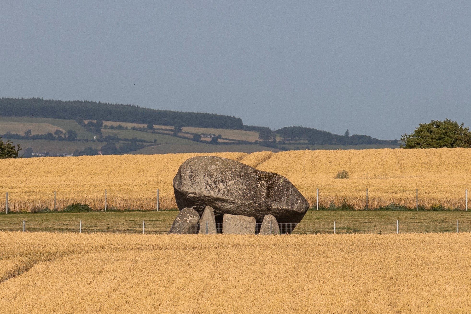
Another significant feature in the demesne is the Brownshill Dolmen.
|
General Recommendations
|
Landscape – Policies
It is the policy of Carlow County Council and Laois County Council to:
| LC. P1: | Protect significant views of landmark structures in Carlow-Graiguecullen. |
| LC. P2: |
Protect the character and setting of demesne landscapes in Carlow-Graiguecullen, including Oak Park Demesne to the north of the joint urban area and Brownshill Demesne to the east. |
| LC. P3: | Protect and enhance the landscape character of the joint urban area, having regard to the assigned Landscape Character Types in Map 10.4 and recommendations in Section 10.4, and to urban gateways, key open spaces, landmark structures, and to important landscape features such as at the River Barrow and Burren River. |
| LC. P4: | Ensure that development will not have a disproportionate landscape or visual impact in the joint urban area, due to siting, layout, design, or excessive size or scale. |
| LC. P5: | Protect and maintain the landscape quality and visual integrity of river corridors in Carlow-Graiguecullen, including the River Barrow and Burren River. |
| LC. P6: | Ensure the effective management of lands adjoining the River Barrow and Burren River and in a manner that maximises views and interactions with these important landscape features in the joint urban area, taking account of the environmental sensitivities of these lands and the need to ensure impacts to biodiversity and nature conservation interests are avoided. |
| LC. P7: | Require, where appropriate, Landscape/Visual Impact Assessments to be prepared by suitably qualified professionals, for development proposals which may have significant landscape or visual impacts in the joint urban area, and/or which are located within or adjacent to sensitive landscapes such as river corridors and demesne landscapes. |
| LC. P8: | Ensure that features which contribute to local landscape character in Carlow-Graiguecullen, including historic features and buildings, trees, hedgerows, shelter belts and stone walls, are retained, protected, and enhanced where appropriate, so as to preserve the appearance and local landscape character of an area, whilst supporting sustainable landscape change and development. Development proposals necessitating the removal of such features will be discouraged. |
| LC. P9: | Preserve historic place and street names in Carlow-Graiguecullen and ensure that the names of all new developments take account of local historical, heritage and cultural associations in the joint urban area. |
Landscape - Objectives
It is an objective of Carlow County Council and Laois County Council to:
| LC. O1: | Ensure that landscape/visual impact assessment will be a key consideration in the assessment of development proposals in Carlow-Graiguecullen. |
| LC. O2: | Ensure that the management and assessment of development in Carlow-Graiguecullen takes account of the recommendations and assigned Landscape Character Types detailed in Section 10.4 and Map 10.4. |
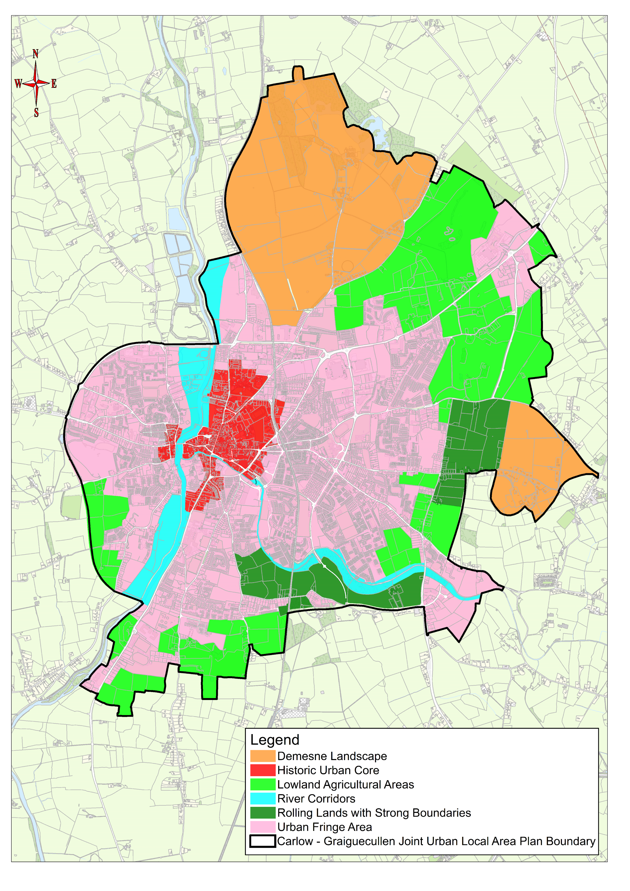
Map 10.4: Carlow-Graiguecullen Landscape Character Assessment