Chapter 5: Sustainable Travel and Transportation
Aim: To maintain and improve the effectiveness of the County’s road network, supporting and providing for more sustainable modes of transport within an integrated land use and transportation framework while supporting the transitioning to a lower carbon-based climate resilient future.
5.0 Introduction
The transportation system caters for the movement of people and goods within and through the county. The delivery and maintenance of a well-functioning multi modal transport network is essential in transitioning to more sustainable modes of transport which in turn will facilitate the delivery of economic competitiveness and improved quality of life. The Council will seek to positively promote, facilitate and require the enhancement of both public transport carrying capacity and road capacity to support sustainable future development.
5.1 Policy Context
Sustainable travel and transportation are underpinned by policy at a national and regional level. The implementation of a County Development Plan which is consistent with these strategic policy documents will provide a strong framework for the delivery of more sustainable travel options further contributing to wider economic, social and environmental objectives of this Plan. Key transportation policy documents which have informed the preparation of this Plan include;
5.1.1 National Planning Framework, National Development Plan.
Project Ireland 2040 supports the provision of a well-functioning integrated public transport system, enhancing competitiveness, sustaining economic progress and enabling sustainable mobility choices for citizens. In this regard, specific National Strategic Objectives seek to achieve the foregoing through requiring compact growth in towns and villages, achieving high quality international connectivity and transitioning to a low carbon and climate resilient society. The national investment priorities that will underpin the implementation of the National Planning Framework are contained in The National Development Plan 2018-2027 and will be further supported by the publication of the National Investment Framework for Transport for Ireland.
5.1.2 Regional Spatial and Economic Strategy for the Southern Region (RSES)
The Regional Spatial and Economic Strategy for the Southern Region seeks to build a strong, resilient sustainable region. This is to be achieved through eleven key components one of which is “Transforming our transport systems towards well-functioning, sustainable integrated public transport, walking and cycling and electric vehicles.” RSES principles have informed the integration of land use and transportation policies of this Plan and include supporting compact growth, strengthening inter and intra-regional road and rail connectivity, protecting the capacity of inter-urban road connectivity, protecting the strategic capacity and safety of the region’s transport network, together with providing public transport and sustainable transport mode. The RSES specifically;
- Encourages a transition towards sustainable and low carbon transport modes through the promotion of alternative modes of transport and ‘walkable communities’; (i.e. 10 Minute Town Concept)
- Supports a local transport plan for Carlow Town;
- Supports the delivery of enhanced rail services;
- Supports the delivery of bus projects and the Local Link Rural Transport Programme;
- Supports the delivery of road projects e.g. N80 upgrade and Southern Relief Road;
- Encourages an increase in electric vehicles;
- Promotes mobility management and travel plans to bring about behavioral change and more sustainable transport use.
5.1.3 Climate Action Plan 2019/2021
In 2017, transport accounted for 19.8% of Ireland’s greenhouse gases and was recognised as a key challenge in Ireland’s Climate Action Plan (DCCAE, 2019). The objective of the plan was to enable Ireland to meet its EU targets to reduce carbon emissions by 30 percent between 2021 and 2030 and to lay the foundations for achieving net zero carbon emissions by 2050. Measures to contribute to the achievement of same in the transportation sector include a significant increase in electric vehicles on the road (936,000 by 2030) improved public transport, cycling and walking infrastructure, conversion of public fleets to zero carbon alternatives, incentives and regulation and roll out of a comprehensive national charging network together with an increased use of biofuels etc.
The new Climate Action Plan 2021 identifies that transport (excluding international aviation) accounts for approximately 20% of Ireland’s greenhouse gas emissions, with 96% of these emissions arising from road transport. A detailed approach is provided for taking decisive action to achieve a 51% reduction in overall greenhouse gas emissions by 2030. The goal of the 2021 Plan is to successfully reduce emissions from the transport sector while maximising the benefits of the transition, and without negatively impacting on economic wellbeing or different social groups.
5.1.4 Smarter Travel – A Sustainable Transport Future – A New Transport Policy for Ireland 2009-2020 (Department of Transport, 2009)
Smarter Travel is the transport policy for Ireland that sets out how the vision of a sustainable travel and transport system can be achieved. It contains five key goals:
- To reduce overall travel demand.
- To maximise the efficiency of the transport network.
- To reduce reliance on fossil fuels.
- To reduce transport emissions.
- To improve accessibility to transport.
This policy recognises the importance of continued investment in transport to ensure an efficient economy and continued social development. It also provides funding to improve facilities for cyclists, walkers and public transport users.
The National Cycle Policy Framework 2009-2020 (Department of Transport) which is derived from Smarter Travel, sets out a national policy for cycling, to create a stronger cycling culture, a safer environment for cycling and improved quality of life.
Ireland’s Sustainability Mobility Policy (active travel and public transport) is currently under review by the Department of Transport Tourism and Sport and will inform future policy in the area of smarter travel.
5.1.5 Spatial Planning and National Roads Guidelines for Planning Authorities (DoEHLG, 2012)
The national road network is a critical enabler in facilitating a sustainable transport system. Planning policy considerations relating to development affecting National Primary and Secondary roads, including motorways and associated junctions, outside the 50-60 kmph speed limit zones for towns and villages is contained in the Spatial Planning and National Roads Guidelines for Planning Authorities.
The Guidelines seek to achieve and maintain a safe and efficient network of National Roads in the broader context of sustainable development strategies, thereby facilitating continued economic growth, while encouraging a shift towards more sustainable travel and transport in accordance with the Smarter Travel policy document.
5.1.6 Design Manual for Urban Roads and Streets
The Design Manual for Urban Roads and Streets (DMURS) prepared for the Department of the Environment, Community and Local Government and Department of Transport, Tourism and Sport (updated in 2019) provides mandatory guidance for all urban roads and streets within the 60km/h urban speed limit. In response to the Covid-19 Pandemic, a supplementary DMURS Interim Advice Note was also published in 2020 on the DMURS website (available to download at www.dmurs.ie/supplementary-material). The design standards for urban roads and streets seeks to balance the “place function” (i.e. the needs of residents and visitors) with the “transport function” (i.e. the needs of pedestrians, cyclists, public transport, cars and goods vehicles) while incorporating good planning and design practice with a focus on the public realm. The manual recognises the importance of assigning higher priority to pedestrians and cyclists, without unduly compromising vehicle movement in order to create secure, connected places that work for all members of the community.
The Council acknowledges the objective of achieving a better balance in how urban roads and streets are designed and used and will actively implement the principles, approaches and standards set out in the Manual in seeking to achieve best practice design outcomes with regard to street networks and individual streets.
5.2 Integration of Land Use and Transportation
The Council acknowledges the fundamental link between transport and land use to reduce reliance on car-based travel and to ensure more sustainable patterns of travel, transportation and development. The need to consolidate and concentrate development in a manner that allows the effective provision of, and ready access to public transport is acknowledged through the appropriate zoning of lands and implementation of development management standards that support appropriate densities and mixed-use developments. Prioritisation of integrated transport and land use, supported by investment in public transport, active travel networks and shared, low carbon mobility options will improve people’s travel choices and support safe, sustainable and healthy lifestyles.
Integration of Land Use and Transportation - Policy
It is the policy of the Council to:
| LT. P1: | To actively support sustainable modes of transport through appropriate land use zonings and to encourage levels of development with mixed uses within walking distance of public transport nodes on well located accessible sites in town and village centres throughout the County. |
5.3 Sustainable Mobility / Modal Shift
Sustainable mobility can be described as linking people and places in a sustainable way by supporting:
- comfortable and affordable journeys to and from work, home, school, college, shops and leisure;
- travelling by cleaner and greener transport; and
- a shift away from the private car to greater use of active travel (walking and cycling) and public transport (e.g. bus, rail).
The Council will seek to influence overall travel demand and achieve a modal shift through land use planning, optimising opportunities to make sustainable travel choices, providing a high-quality transport network and system which is effective, accessible and responsive to technological change and reduces the contribution of transport to climate change. The transport sector accounts for 41% of County Carlow’s total final energy consumption (Ref: Carlow Renewable Energy Strategy Appendix VI).
Table 5.1: Modes of Travel to Work, School and College 2016
|
Travel Mode Share for Trips to Work, School and College |
Numbers |
Percentage |
|
On foot |
4,851 |
15.2% |
|
Bicycle |
368 |
1.2% |
|
Bus, Minibus or coach |
1,964 |
6.2% |
|
Train, Dart or Luas |
324 |
1% |
|
Motorcycle or scooter |
38 |
0.1% |
|
Car driver |
14,442 |
45.2% |
|
Car passenger |
8,094 |
25.3% |
|
Van |
1,878 |
5.8% |
|
Total |
31,959 |
100% |
Source: CSO 2016
Table 5.1 contains details of the mode of travel to work and to school / college of people normally resident in County Carlow in 2016. The mode share for commuting by private motor vehicle to work and education in County Carlow represents 76% which is higher than the rest of the country at 68% and significantly above the national target of 45% for car commuting trips.
Table 5.2: Modes of Travel to Work, Carlow Town, Tullow and Muine Bheag
|
Means of Transport to Work |
Carlow Town |
Tullow |
Muine Bheag |
|
Other |
2.9% |
4.4% |
2.2% |
|
Green |
12.4% |
13.0% |
12.0% |
|
Public |
1.1% |
0.0% |
0.5% |
|
Private |
83.6% |
82.5% |
85.3% |
Source: CSO 2016
The proportions travelling to work in the top two tiers of the Settlement Hierarchy (Carlow Town, Tullow and Muine Bheag) indicate a heavy reliance on the private car (Ref: Table 5.2).
Achieving significant modal shift is dependent on a wide range of factors including government investment in public transport, active travel and shared mobility as viable alternative travel options. Given the dispersed distribution of the population in Carlow, the provision of public transport outside of the larger urban centres is a significant challenge. The Council will however, seek to support a more sustainable mode of travel through Transport Demand Management 1in consultation with the NTA. Interventions identified in Project Carlow 2040; A Vision for Regeneration will support more sustainable travel patterns through public realm initiatives that aim to reduce overall car numbers and allow for more green space for walking and cycling with a focus on greater use of outdoor space and increased use of public transport. The provision of increased walking and cycling infrastructure throughout the County will be delivered through engagement in a collaborative manner with service providers, significant employers and educational facilities to support more sustainable travel patterns.
Modal Shift - Policy
It is the policy of the Council to:
| MS. P1: | Seek investment in sustainable transport solutions, improved walking and cycling connectivity routes, the provision of a public bus service in Carlow Town and the expansion of rural transport initiatives throughout the county. |
Modal Shift - Objective
It is an objective of the Council to:
| MS. O1: |
Support modal shift at a County level from private vehicles to sustainable modes (walking, cycling Bus or Train) to access work, school, college from 23% in 2016 (Ref: Table 5.1) to 28% in 2028. |
| MS. O2: |
To prepare local transport plans, based on the Area Based Transport Assessment (ABTA) approach in consultation with NTA, TII, IE and relevant stakeholders for Carlow Town, Tullow and Muine Bheag which will form an iterative process with the review of the relevant Local Area Plan and will include specifying baseline figures and ambitions /targets for modal share, in order to encourage a modal shift away from the private car to more sustainable forms of transport, such as public transport, cycling and walking. |
5.4 Walking and Cycling
The proportion of persons walking and cycling to work, school and college declined between 2011 (17.5%) and 2016 (16.1%). Within Carlow Town a considerable percentage of people (22%) walk as a means of transport reflecting the concentration of services, employment and other facilities within the town. Only 2% of trips are made by bike within County Carlow significantly below the national target of 10% commuting by bike by 2020.
The Council recognises the importance of both walking and cycling in minimising environmental impacts while also contributing to improved wellbeing and quality of life. Investment in cycling has taken place in Carlow in recent years, with the provision of cycling lanes along the N80 bypass in Carlow Town and some of the regional roads. Increasing the proportionate uptake of these sustainable modes of travel is dependent on the convenience of walking or cycling as an option which directly relates to the level of connectivity, road safety and the quality of facilities provided.
It is a key objective of Carlow County Council to seek the implementation of Project Carlow 2040; “A Vision for Regeneration” which contains a detailed walking and cycling strategy for Carlow Town. It provides for a number of new pedestrian routes within Carlow, linking residential areas to key attractions, with a focus on removing severance and improving connectivity together with improved pedestrian infrastructure (e.g. footpaths, safe crossings, junction upgrades etc.). Similarly, the cycling strategy has been prepared to address existing gaps and facilities in the network focussing on creating a series of safe and continuous segregated cycle routes, linking residential communities to places of employment, education, recreation and the town centre.
The Council will through the implementation of the Design Manual for Urban Roads and Streets (2013 and updated 2019), the Permeability Best Practice Guidelines (2013), the National Cycle Policy Framework (2013) and the National Cycle Manual (2011) seek to make walking and cycling more attractive modes of travel. The Council also supports the Toolkit for School Travel (2013) which promotes cycling and walking for trips to school and will seek to provide and facilitate the provision of safe routes to school.
The Council will, in the exercise of its functions in land use planning, development management and provision of roads and street infrastructure, facilitate and promote high quality, convenient, pleasant and safe walking and cycling in urban and rural areas that allows for multiple direct connections between key destinations.
Walking and Cycling - Policies
It is the policy of the Council to:
| WC. P1: |
Prioritise and promote more sustainable and convenient modes of travel by the development of high quality walking and cycling infrastructure including greenways within a safe environment. |
| WC. P2: |
Work with the National Trails Office, Coillte, relevant Government Departments, and other relevant stakeholders, to improve on the existing level of infrastructure and facilities for walking and cycling. |
| WC. P3: |
Ensure that connectivity for pedestrians and cyclists is maximised in new communities and improved within existing areas particularly towns and villages throughout the county including associated infrastructure, to maximise access to local shops, educational facilities, public transport services, employment locations and other amenities. |
| WC. P4: |
Provide for safer routes to schools within the County and promote walking and cycling as suitable modes of transport as part of the Green Schools Programme and other local traffic management improvements. |
Walking and Cycling - Objectives
It is the objective of the Council to:
| WC. O1: |
Seek the implementation of the Walking and Cycling Strategy for Carlow Town and specific projects as contained in Project Carlow 2040 “ A Vision for Regeneration” creating more sustainable communities, with an emphasis on encouraging active travel to reduce car dependency. |
| WC. O2: |
Ensure that all streets and street networks seek to facilitate permeability, are designed in accordance with best practice standards including the Design Manual for Urban Roads and Streets and the National Cycle Manual which seek to prioritise the movement of pedestrians and cyclists within a safe and comfortable environment for a wide range of ages, abilities and journey types. |
| WC. O3: |
Reduce walking and cycling distances to areas of employment, community services, schools, shops, public transport and other community facilities through implementation of the 10 Minute Town Concept, the provision and maintenance of high-quality linkages and the delivery of local permeability links within existing communities. |
| WC. O4: |
Prioritise where required the upgrade and maintenance of footpaths, cycleways, public lighting, traffic management and public realm works and supporting signage on public roads / paths. |
| WC. O5: |
Provide secure high-quality cycle parking facilities in public areas and strategic sites in towns and at public service destinations. |
| WC. O6: |
Improve pedestrian and cycle connectivity to rail station locations and other public transport interchanges within the county. |
| WC.O7: |
Secure the development of the following specific schemes :
|
5.5 Public Transport
The provision of a high quality integrated public transport system in conjunction with appropriately located land use zonings is paramount to secure a reduction in carbon emissions and in providing a viable sustainable alternative transport mode. Central to County Carlow’s future success will be the creation of a high-quality public transport network particularly within Carlow town connecting people to key destinations within the town in a reasonable travel time.
The Public Transport Strategy as contained in Project Carlow 2040 “A Vision for Regeneration” includes a set of recommendations to improve accessibility for public transport, in particular to Carlow Coach Park, Carlow Railway Station, Taxis and the Carlow Proposed Town Bus Service. The integration of public transport with other modes (through the development of mobility hub facilities at the Railway Station and Coach Park) are promoted together with support for the provision of Carlow Town Bus Service as proposed by the National Transport Authority.
The Council will seek to influence the provision of sustainable bus and rail services by ensuring enabling infrastructure is provided, development is appropriately located and provided to an optimum scale and density. The Council will act where it can to implement any policy changes, guidance and actions where appropriate which support an improved and integrated public transport infrastructure / service within the county.
5.5.1 Rail
A modern, efficient and dependable passenger and freight rail network has a crucial role to play in mitigating climate impacts and in promoting County Carlow for business, industrial, residential and recreational purposes.
Carlow and Muine Bheag are serviced by the Dublin to Waterford intercity rail line. The Rail Vision 2030: The Future of Rail Transport in Ireland notes that the Dublin – Carlow line comprises one of high levels of demand on the mainline routes. Services from Carlow however are infrequent, with an hourly frequency at peak times and gaps of up to three hours between services during the day. Improvements to frequency and timetabling would improve Carlow’s rail connectivity with the wider Eastern and Southern Region. In this regard, it should be noted that as part of their Strategy 2027, which will have positive implications for rail connectivity from County Carlow, Iarnród Éireann is planning to enhance rail connectivity options to the north of Carlow at Kildare, including onward opportunities to Dublin, the West and South West of the country. Iarnród Éireann’s Rail Freight 2040 Strategy addresses the reintroduction of new freight services on the rail network.
The Council supports the Strategic Rail Review which will examine the rail network across Ireland to improve sustainable connectivity, enhance regional accessibility and support balanced regional development. Any upgrade of the Dublin – Waterford rail line and any potential future redevelopment of the Limerick-Waterford- Wexford rail link would support more sustainable travel patterns within Carlow and the wider Southern Region.
5.5.2 Bus
The development of a quality bus system as an alternative to the private car is an essential element of an integrated and balanced land use transport system. Bus Eireann and private service providers operate public bus services in County Carlow. The delivery of a Carlow Town Bus Service in conjunction with the NTA is an objective of this Plan which will seek to connect the majority of residential areas within the town to the main employment, retail, health and education destinations. The provision of new direct pedestrian / cyclist paths to the bus stops from residential areas will shorten the distance, therefore improving the accessibility for residents living in these areas to the town bus network, thereby supporting the development of the ‘10 – minute Town’ concept.
The NTAs ‘Local Link Rural Transport Programme Strategic Plan 2018 to 2022’ aims to provide a quality nationwide community based public transport system in rural Ireland which responds to local needs. Its key priorities include the reduction of social exclusion and the integration of rural transport services with other public transport services. In addition, one of its key objectives is greater interaction/co-ordination with Local Authorities regarding the assessment of strategic transport needs and in the development of proposed transport plans for local areas. Rural transport services can perform an important role in providing for social and economic connectivity between small villages/rural areas and larger towns.
While a service is provided in County Carlow greater connectivity and service provision is required between settlements in the county and wider region.
Carlow County Council will facilitate the improvement and expansion of bus services where they strengthen linkages to other areas of the county, adjoining regions including the Greater Dublin Area, designated key towns and the rest of the country.
Public Transport- Policies
It is the policy of the Council to;
| PT. P1: |
Promote the sustainable development of the County by supporting and guiding national agencies in delivering improvements to the public transport network / services and associated infrastructure including services and infrastructure at the rail stations at Bagenalstown and Carlow Town, thereby promoting integrated services and to seek to ensure that public transport services provide an attractive and convenient alternative to the car. |
| PT. P2: |
Support transport agencies, including the National Transport Authority (NTA) and public service transport providers in the provision of new public transport services and routes, enhancement of the quality, frequency and speed of existing train and bus public transport services with measures incorporated to facilitate access for all. |
| PT. P3: |
Seek to generate additional demand for public transport services through integrated land use planning and maximising access to existing and planned public transport services throughout the network. |
| PT. P4: |
Ensure that public transport infrastructure, as required and appropriate, is considered as part of any significant residential or commercial development proposals e.g. evaluation for requirement for new bus stops, turnaround facilities, pedestrian access, and layover facilities. |
Public Transport- Objectives
It is an objective of the Council to;
| PT. O1: |
Prepare a Local Transport Plan for Carlow Town in accordance with the Area Based Transport Assessment Guidelines (produced by the NTA and TII) and having regard to RPO 157 of the RSES for the Southern Region. The LTP will include priorities for public transport infrastructure and services, cycle investment, improvements to the pedestrian environment and road enhancements. The policies, objectives and measures which emerge from the LTPs will inform the Joint Urban Area Plan for the Greater Carlow Urban Area. |
| PT. O2: |
To seek the implementation of measures to improve accessibility to public transport as contained in Project Carlow 2040 “A Vision for Regeneration” creating more sustainable communities, with an emphasis on encouraging active travel to reduce car dependency. |
| PT. O3: |
To seek the delivery of Carlow Town Bus Service in conjunction with the National Transport Authority and to facilitate appropriately located bus stops and adequate waiting areas, real time passenger information and secure cycle parking at key bus stop locations. |
| PT. O4: |
Seek the delivery of a transport node in the immediate vicinity of Carlow Train Station facilitating integration of local bus services and private transport modes with the rail network which will facilitate easy exchange between modes and / or routes. |
| PT. O5: |
Support and encourage the improvement and expansion of rural transport initiatives and bus shelters in conjunction with other statutory and development agencies. |
5.6 Park and Ride
In order to encourage more sustainable travel modes thereby facilitating greater usage of public transport, reducing congestion and carbon emissions, the provision of “park and ride” sites at appropriate locations which facilitate car commuters transferring to public transport will be encouraged.
Park and Ride - Policy
It is the policy of the Council to;
| PR. P1: |
Promote and support the provision of “park and ride” facilities at appropriate locations with suitable charging infrastructure subject to a full appraisal of each location and in consultation where relevant with the transport authority / service providers. |
5.7 Electric Vehicles and Low Emission Vehicles
Transitioning to a low carbon economy requires increased emphasis on the use of electric vehicles and low emission vehicles. To support same the provision of appropriate levels of infrastructure are required throughout the county. Public realm electric vehicle charging points are distributed throughout County Carlow, strategically located in Carlow Town, Tullow and Muine Bheag. This Plan promotes the further installation and expansion of the charging point network throughout the county.
Alternative low emission fuel infrastructure is also required for the various other low emission vehicle options including hydrogen, biofuels and natural gas. Under Article 3(4) of the Renewable Energy Directive, Ireland is committed to ensuring that at least 10% of energy consumption in the transport sector is achieved from renewable sources by 2020.
Electric Vehicles and Low Emission Vehicles - Policies
It is the policy of the Council to:
| EV. P1: |
Support the Government’s targets for electric vehicles on roads by facilitating the roll-out of Electric Powered Vehicle Recharging Parking Bays for electric vehicles in accordance with Government requirements across the county through the planning system and on public roads. |
| EV. P2: |
Support and facilitate the roll-out of alternative low emission fuel infrastructure through the Development Management Process. |
Electric Vehicles and Low Emission Vehicles - Objectives
It is an objective of the Council to;
| EV. O1: |
Facilitate the increased provision of electric vehicle charging points throughout the public realm space, subject to availability of finances through Public Charge Point Scheme or other funding streams that may become available during the life of this Plan. |
5.8 Road Infrastructure
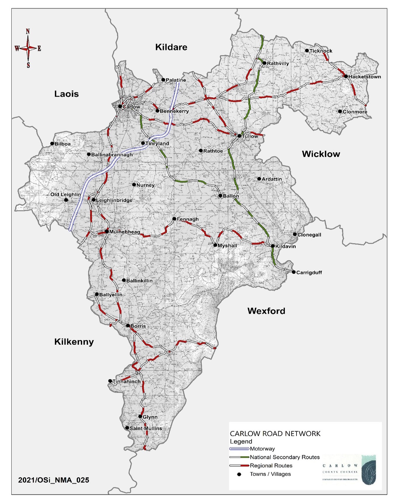
While it is acknowledged that the provision of more sustainable transport options is a priority over the plan period, it is also recognised that roads infrastructure given the rural nature of the County will continue to maintain a central position in the overall transportation network. The road infrastructure provides intra and inter county movement of goods and services and supports rural populations and businesses who are largely reliant on private vehicular transport and the road network. (Ref: Map. No. 5.1 Road Network).As of 2021, County Carlow has approximately 1,327 kilometres of roads which are categorised as follows:
|
Road Type |
Distance (km) |
Share of Carlow’s Roads (%) |
|
Motorway |
24 |
2 % |
|
National Roads |
55 |
4 % |
|
Regional Roads |
186 |
14 % |
|
Local Roads |
1,062 |
80 % |
|
Total |
1,327 |
----- |
Table 5.3: Road Type Network Co. Carlow
The Council recognises the importance of providing a safe and efficient road network throughout the county. The Council is committed to enhancing the county’s international, national, regional and local connectivity in order to retain and strengthen its economic competitiveness, to attract inward investment, to further develop the local and national economy, to protect the safety of road users while safeguarding investment in their provision.
5.8.1 Motorway Network
Carlow is serviced by the M9 Motorway traversing the County, providing strategic connections to the metropolitan areas of Dublin City, Kilkenny City, Waterford City, in addition to Waterford Port and onwards.
The motorway network primarily serves long and middle-distance traffic originating in or passing through the County including the transportation of freight. This route has an important role to play in the economic development of the county. Responsibility for the future development and the operation of the motorway network rests with Transport Infrastructure Ireland.
Motorway Network - Policies
It is the policy of the Council to:
| MN. P1: |
Work with Transport Infrastructure Ireland to develop and operate the motorway network through the County and to seek to ensure that the capacity, efficiency and safety of the network and associated junctions is maintained in accordance with the Spatial Planning and National Roads Guidelines for Planning Authorities DECLG (2012). |
| MN. P2: |
Ensure that the capacity, efficiency and safety of the motorway route within Carlow is protected and to control development that could impact traffic safety and / or hinder the future upgrading of motorway routes and interchanges. |
| MN. P3: |
Support and facilitate the adequate provision of Motorway Service Stations in accordance with the Spatial Planning and National Roads Guidelines for Planning Authorities DECLG (2012) and the NRA Motorway Service Area Policy guidance document (2014 or as maybe amended during the life of this Plan). |
Motorway Network - Objectives
It is an objective of the Council to;
| MN. O1: |
Support Transport Infrastructure Ireland to further develop and operate the motorway network through the County. |
Map 5.1 County Carlow Road Network
5.8.2 National Road Network
Carlow is served by the N80 and N81 National Roads traversing the county. The N80 is a strategic link, connecting the Midlands Region to the South-East Region, serving the key towns of Tullamore, Portlaoise, Carlow and Enniscorthy, in addition to connecting with the M7 and M8 motorways providing onward connectivity with Limerick and Cork. South of the N80 via the N11 and N25 onward connectivity is provided to Wexford Town and Rosslare Europort. Extending from the N80, the N81 route provides access to Dublin City to the north-east including access to key settlements of Tullow and Blessington.
The national road network has a strategic role in catering for inter-urban and inter-regional transport requirements and has an important role to play in the economic development of the county. Responsibility for the future development and the operation of the national road network rests with Transport Infrastructure Ireland.
National Road Network - Policies
It is the policy of the Council to:
| NR. P1: |
Co-operate with Transport Infrastructure Ireland to maintain and develop the national road network (N80 and N81) through the county and to seek to ensure that the capacity, efficiency and safety of the network and associated junctions is maintained in accordance with the Spatial Planning and National Roads Guidelines for Planning Authorities DECLG (2012). |
| NR. P2: |
Avoid the creation of additional access points from new development or the generation of increased traffic from existing accesses to the national road to which speed limits of greater than 50 kph applies in accordance with the Spatial Planning and National Roads Guidelines for Planning Authorities DECLG (2012). |
| NR. P3: |
Ensure that the capacity, efficiency and safety of the national road network within Carlow is protected and to control development that could impact traffic safety and / or hinder the future upgrading of the national road network. |
| NR. P4: |
Regulate, control and improve signage throughout the County, in conjunction with Transport Infrastructure Ireland (TII) and other relevant agencies. The Council will have regard to TII Policy on the Provision of Tourist and Leisure Signage on National Roads and Section 3.8 of the Spatial Planning and National Road Guidelines which indicates a requirement to control the proliferation of non-road traffic signage on and adjacent to national roads. |
| NR. P5: |
To implement Section 2.8 of the DoECLG Spatial Planning and National Roads Guidelines relating to the provision of service areas and roadside facilities on national roads or any updates thereto during the life of this Plan and subject to meeting all other planning and environmental criteria. |
| NR. P6: |
Seek to ensure that the capacity and efficiency of the national road network drainage regimes in County Carlow are safeguarded for national road drainage purposes. |
National Road Network - Objectives
It is an objective of the Council to;
| NR. O1: |
Pursue the options and interventions contained in the National Secondary Roads Needs Study 2011- South East Region (or latest approved version). |
| NR. O2: |
To seek delivery of the following improvement / works on / along the national road network;
|
5.8.3 Regional Roads
Regional roads represent circa. 14% of the road network within the County and provide important strategic connections linking the principal towns and villages within the county and the region. They serve long, middle and short-distance traffic originating in or passing through the County. The roads serve rural development and diversification, indigenous industry, local enterprise, agriculture, agri-business and tourism.
To maintain their strategic function, it will be necessary to exercise control over new development requiring access to regional roads, where the posted speed limit exceeds 50km/hr, where there are higher traffic levels and where there is a high proportion of recorded road traffic accidents.
These comprise those listed in Table 5.4 and outlined on Map 5.2.
Table 5.4: Strategic Regional Roads
|
Road No. |
Road Location and Description |
|
R417 |
Carlow Town to Kildare Border |
|
R418 |
Tullow to Kildare Border |
|
R448 |
Kildare border via Carlow Town, Leighlinbridge and Royal Oak Village to Kilkenny Border |
|
R702 |
Kilkenny Border, via Borris and Ballymurphy to Wexford Border |
|
R703 |
Coolnamara Cross to Tinnahinch Village |
|
R705 |
Leighlinbridge via Bagenalstown and Borris to Kilkenny Border |
|
R724 |
Royal Oak via Bagenalstown to Fenagh Village |
|
R725 |
Carlow Town to Tullow Village, extending to Wicklow Border |
|
R726 |
Carlow Town, via Straboe Cross to Cuckoo Corner (junction with N81) |
|
R727 |
Straboe Cross to Hacketstown |
|
R729 |
Borris Village, via Glynn and Drummin to Wexford Border |
|
R747 |
Wicklow Border via Hacketstown to Wicklow Border |
Maintaining the capacity and preservation of enhanced safety standards will be important in ensuring that regional roads can continue to perform important local and regional transportation functions.
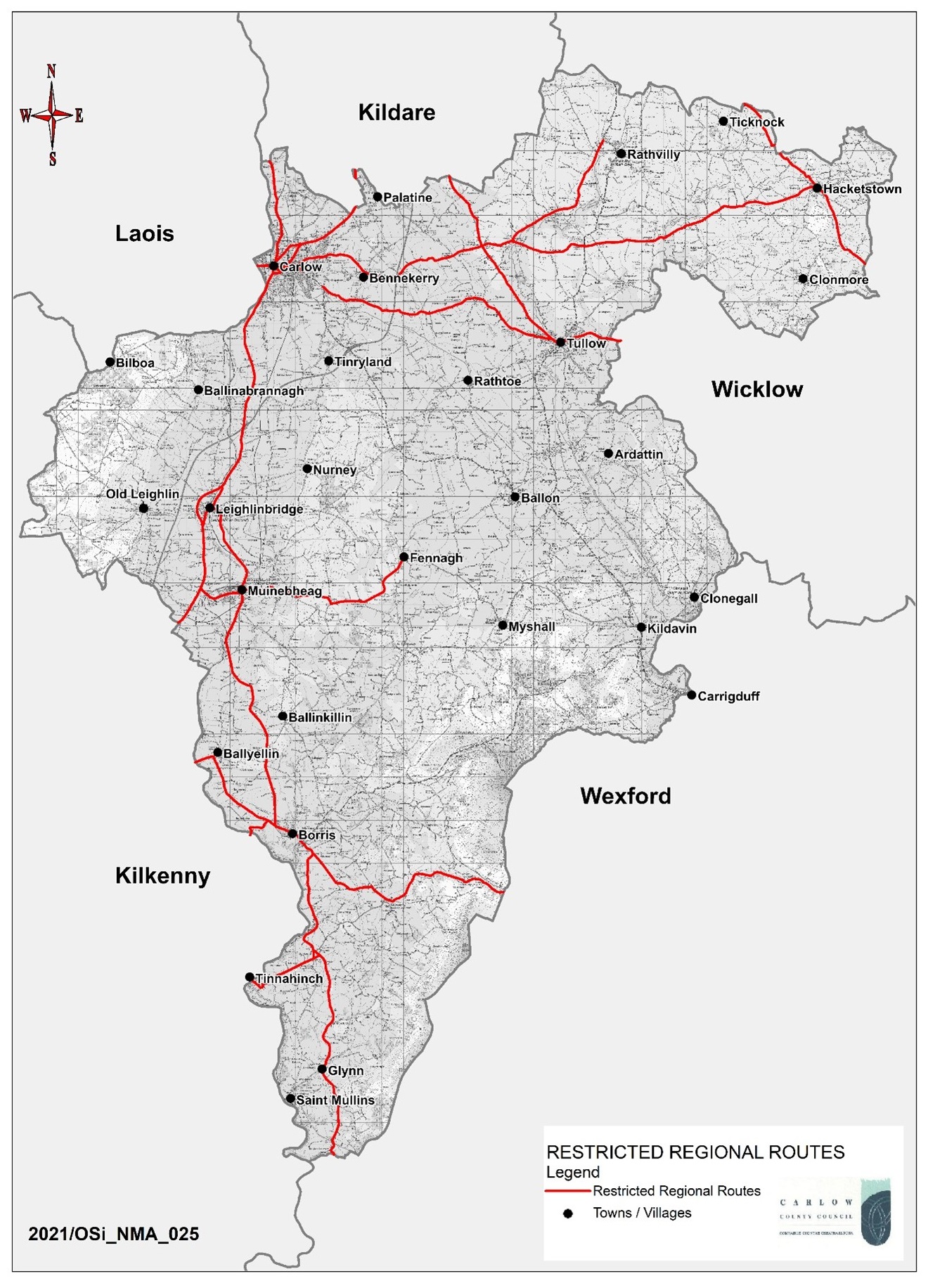 Map 5.2 Restricted Regional Roads
Regional Roads - Policies
It is the policy of the Council to:
| RR. P1: |
Maintain and improve the capacity, safety and function of the regional road network (as finances become available) and to ensure that it is planned for and managed to enable the sustainable economic development of the County and wider area. |
| RR. P2: |
Exercise control over new developments outside of designated settlements requiring direct access to the regional road network which could compromise the capacity, safety and efficiency of these routes. |
| RR. P3: |
Protect strategic regional roads listed in Table 5.4, against development where the posted speed limit exceeds 50km/hr applies in order to protect the carrying capacity of such roads except in exceptional circumstances;
|
Regional Roads - Objectives
It is an objective of the Council to;
| RR. O1: |
Support and facilitate the planning, design and completion of the Southern Relief Route N80-R448 including a new bridging point over the River Barrow, to improve connectivity between the Midlands Region and the South-East Region and to address local traffic management considerations thereby contributing to the local economy of the Greater Carlow Graiguecullen Urban Area2[i] |
| RR. O2: |
Plan for the future provision of the Tullow Outer Relief Road in consultation with the Department of Transport Tourism and Sport, Transport Infrastructure Ireland and all necessary stakeholders. A Strategic Assessment Report / Preliminary Business Case for the provision of this route will be carried out during the life of this Plan to ensure alignment with government policy, the forthcoming Planning Land use and Transportation Outlook 2040, the National Planning Framework and the National Development Plan. |
|
RR. O3: |
Plan for the future provision of the Bagenalstown Relief Road in consultation with the Department of Transport Tourism and Sport, Transport Infrastructure Ireland and all necessary stakeholders. A Strategic Assessment Report / Preliminary Business Case for the provision of this route will be carried out during the life of this Plan to ensure alignment with government policy, the forthcoming Planning Land use and Transportation Outlook 2040, the National Planning Framework and the National Development Plan. |
| RR. O4: |
Seek to undertake a Regional Road Needs Study to determine and prioritise road improvement projects throughout the network. |
| RR. O5: |
Seek to implement the following Regional Road Improvement Schemes:
Given the extent of the network the Council will prioritise available resources in the annual roadworks programme, to remedy those issues found to be structurally deficient in accordance with the nationally developed Pavement Management System (PMS). |
5.8.4 Local Roads
Local roads extend for 1,062km within the county and are divided into Primary, Secondary or Tertiary based on their traffic levels, width and alignment. These roads serve an important function for rural communities, agriculture and other rural based enterprises. Given the extent of this network the Council will prioritise available resources on the more heavily trafficked routes and those found to be structurally deficient in accordance with the nationally developed Pavement Management System (PMS).
Local Roads- Policy
It is the policy of the Council to:
| LR. P1: |
Ensure that the safety and capacity of the local road network is maintained and improved where funding allows to a suitable standard to accommodate the needs of the County. |
Local Roads- Objective
It is an objective of the Council to;
| LR. O1: |
Maintain and improve all local roads in accordance with Department requirements. |
5.8.5 Urban Roads and Streets
The Design Manual for Urban Roads and Streets (DMURS) issued under Section 28 of the Planning and Development Act 2000(as amended) provides guidance on how the objectives of sustainability may be achieved by putting well-designed streets at the heart of sustainable communities and supporting boarder government policies on the environment, planning and transportation. DMURS provides the practical measures to achieve:
- Highly connected streets which allow people to walk and cycle to key destinations in a direct and easy-to find manner.
- A safe and comfortable street environment for pedestrians and cyclists of all ages.
- Streets that contribute to the creation of attractive and lively communities.
- Streets that calm traffic via a range of design measures that make drivers more aware of their environment.
The design of urban streets is governed by DMURS which is mandatory for all urban roads and streets within the 60km/h urban speed limit zone except for:
- Motorways; and
- In exceptional circumstances, certain urban roads and streets with the written consent of the relevant Sanctioning Authority.
Urban Roads and Streets - Policy
It is the policy of the Council to;
| UR.P1: |
Ensure that all urban roads and streets in our towns and villages, including residential streets in housing estates are designed in accordance with the principles, approaches and standards set out in the ‘Design Manual for Urban Roads and Streets’ (2013/2019) and any further update to the Manual during the life of this Plan and to implement TII Publication Standard DN-GEO-03084 ‘The Treatment of Transition Zones to Towns and Villages on National Roads’ as appropriate. |
| UR.P2: |
Consider, and, where appropriate to seek the implementation of a wider 30kph speed limit zone in urban environments in order to create a safer, calmer and more pleasant urban environment for pedestrians, cyclists and motorists, fostering opportunities for active travel and protecting vulnerable road users. |
Bridges
Over 250 bridges are dispersed throughout the County which support the non-national network. The Council continues to adopt a pro-active role in maintaining, preserving and strengthening these bridges. Given the extent of the bridge network the Council will prioritise available resources in the annual roadworks programme, to remedy those found to be structurally deficient in accordance with the nationally developed Pavement Management System (PMS)
Bridges - Policy
It is the policy of the Council to;
| BR.P1: |
Seek the maintenance, preservation and upgrade of bridges along the public road and to ensure that any bridges deemed of historic, architectural or cultural heritage value are maintained and upgraded in accordance with best conservation practices and are informed by ecological assessments and the requirements of the Habitats Directive regarding Appropriate Assessment. |
5.9 Infrastructural Improvement Process
All National Road projects excluding TII National Road Schemes which will be progressed in accordance with TII Project Management Guidelines and Project Appraisal Guidelines will be progressed in accordance with the “TII Project Management Guidelines, while Non-National Road Improvement projects will comply with the Department of Transport Guidance for the “Management and Appraisal of Regional and Local Strategic and Specific Road Improvement Programmes”. Compliance must also be outlined in accordance with the “Public Spending Code- A Guide to Evaluating Planning and Managing Public Investment”. In this regard and subject to available resources, the following process will be undertaken for relevant new roads infrastructure:
Stage 1 – Strategic Assessment (Scope and Pre-appraisal)
Stage 2 – Preliminary Business Case (Concept and Feasibility, Options Selection, Design and Environmental Evaluation).
Stage 3 – Final Business Case (Statutory Processes, Enabling and Procurement)
Stage 4 – Implementation (Construction)
Stage 5 – Review (Project close-out).
New roads and other transport infrastructure projects (including greenways, blueways and cycleways) referred to by this Plan that are not already provided for by plans/ programmes other than the County Development Plan or are not already permitted, are subject to the undertaking of feasibility assessment, taking into account planning need, environmental sensitivities as identified in the SEA Environmental Report and the objectives of the Plan relating to sustainable mobility. Where feasibility is established, a Corridor and Route Selection Process will be undertaken where appropriate, for relevant new road infrastructure in two stages:
Stage 1 – Route Corridor Identification, Evaluation and Selection
- Environmental constraints (including those identified in Section 4 of the SEA Environmental Report) and opportunities (such as existing linear infrastructure) will assist in the identification of possible route corridor options;
- Potentially feasible corridors within which infrastructure could be accommodated will be identified and these corridors assessed. The selection of the preferred route corridor will avoid constraints and meet opportunities to the optimum extent, as advised by the relevant specialists; and
- In addition to the constraints identified above, site-specific field data may be required to identify the most appropriate corridors.
Stage 2 – Route Identification, Evaluation and Selection
- Potentially feasible routes within the preferred corridor will be identified and assessed. The selection of preferred routes will avoid constraints and meet opportunities to the optimum extent, as advised by the relevant specialists, taking into account project level information and potential mitigation measures that are readily achievable;
- In addition to the constraints identified above, site specific field data may be required to identify the most appropriate routes; and
- In addition to environmental considerations, the identification of route corridors and the refinement of route lines is likely to be informed by other considerations.
Infrastructural Improvement – Policy
It is the policy of the Council to:
| II.P1: |
Preserve corridors identified as part of the infrastructure improvement process which are informed by the route corridor identification, evaluation and selection process to enable design options for road improvements and upgrades to be advanced. |
Freight
Freight transport and logistics will require a shift to more sustainable means of transport, including rail. The RSES acknowledges the network potential of Carlow and Kilkenny on the Carlow-Dublin M9/ Rail Network, along a key north-south axis through the region, linking the Waterford Metropolitan Area, Kilkenny City and Carlow Key Town with Dublin and the Eastern and Midlands Region. The M9 Motorway and rail network provide direct access from a large inland area to the Port of Waterford and Waterford Airport with potential opportunities for more sustainable freight movements to the Port.
Freight - Policy
It is the policy of the Council to;
| FR. P1: |
Promote the development of rail freight services and support the development of a logistical park within the County together with rail freight services in accordance with the forthcoming Regional Freight Strategy (RSES). |
| FR. P2: |
Promote and support the provision of an appropriately located logistics park within the county subject to all planning and relevant environmental considerations. |
5.11 Air Travel
The Council supports the continued operation and growth of Waterford Airport as an important element of the transport and communications infrastructure of the region.
Air Travel - Policy
It is the policy of the Council;
| AT. P1: |
In line with EU national and regional policy support in respect of air access from regional airports, to support the continued operation and growth of Waterford Airport, where it would contribute towards proper planning and sustainable development and comply with all environmental legislation and policies and objectives contained within this Plan and higher level planning documents, including the National Planning Framework and Southern Regional Spatial and Economic Strategy, and measures to enhance connections from County Carlow to Waterford Airport and other airports in the country. |
| AT. P2: |
Consider the development of air strips in locations that would not have an adverse impact on residential areas. |
5.12 Travel Plans
Travel plans are required for significant new developments or expansion to developments which give rise to trip intensive developments. They are a means of promoting sustainable means of access, reducing traffic congestion in urban areas and making more efficient use of land by reducing the need for car parking.
Travel Plans - Policy
It is the policy of the Council to;
| TP. P1: |
Require the submission of travel plans with planning applications for all new developments or intensification of existing developments that generate significant trip demand in accordance with ‘Achieving Effective Workplace Travel Plans: Guidance for Local Authorities’ (NTA, 2012). |
5.13 Street Lighting
Appropriate street lighting can positively contribute to road safety and increases personal safety, particularly for vulnerable road users. To ensure well lit roads, footways and cycleways, all street lighting will be provided in accordance with best practice guidelines and standards in terms of type of lighting columns, lantern types, lighting class, Lux levels and energy efficiency.
Street Lighting- Policy
It is the policy of the Council to;
| SL. P1: |
Ensure that public lighting is provided in accordance with relevant EU Norms, National Standards or best guidance documents as appropriate, including any forthcoming Council Public Lighting Specifications and Policy documents. |
Street Lighting- Objective
It is an objective of the Council to;
| SL. O1: |
SL. O1: Improve the efficiency of public lighting assets in order to minimise electricity usage. |
5.14 Car Parking
The Planning Authority will require car parking to be provided at the rates set out in Chapter 16 Development Management Standards. Reduced car parking provision maybe considered for commercial town centre sites in order to tackle urban decline, promote investment and help sustain more sustainable travel modes.
Flexibility in car parking standards for development (including residential) may also be applied in urban infill and brownfield sites in urban areas based on performance criteria in order to achieve targeted growth.
In addition, the shift to electric vehicles requires the installation of charging points across the county and the provision of chargers in domestic dwellings. Developing the infrastructure for alternatively fueled vehicles will be a vital step in encouraging consumers to make more environmentally friendly transport choices.
Car Parking – Policy
It is the policy of the Council to:
| CP. P1: |
Carefully consider the number of car parking spaces required to service the needs of new development. |
| CP. P2: |
Allow for the reduction in car parking requirements for commercial developments in suitable town centre locations where a detailed parking analysis demonstrates adequate supply of proximate car parking spaces thereby encouraging a modal shift away from the private car to more sustainable forms of transport, such as public transport, cycling and walking. |
| CP. P3: |
Seek to ensure that all new private car parking facilities are provided to an appropriate standard, proximate to the development which it serves. |
| CP. P4: |
Ensure that applications for surface car parking are accompanied by landscaping proposals. |
| CP. P5: |
Seek and promote the provision of Age Friendly parking arrangements and further provide for the improvement of parking arrangements for people with disabilities |
| CP. P6 |
Promote and support the development of appropriate infrastructure to accommodate a change to electrically powered vehicles by requiring all new carparks or extensions to existing carparks to include for the provision of electric car charging points, at a rate as outlined in Section 16.10.12. |
| CP. P7 |
To apply flexibility where appropriate in response to well-designed development proposals that can achieve urban infill and brownfield development objectives in urban areas subject to strict qualitative criteria being achieved and provided public safety is not compromised and the environment is suitably protected. |
5.15 Bicycle Parking Facilities
Cycling is becoming increasingly recognised for the contribution it provides as a sustainable and healthy form of transport for work, education and leisure trips within and around the County. Provision of secure cycle parking facilities is essential for supporting the promotion and development of cycling as a more sustainable mode of transport. High quality cycle parking should be regarded as an integral part of any new development.
Bicycle Parking Facilities – Policy
It is the policy of the Council to:
| BP. P1: |
Ensure the provision of appropriate bicycle parking facilities as part of any new applications in urban areas to assist with supporting modal shift away from private cars to more sustainable modes of transport i.e. Cycling, Walking, Public Transport. |
5.16 Directional/ Information/ Waymarking Signage
Directional signage will be permitted at appropriate locations for amenities, tourist attractions, community facilities and local attractions but not for commercial organisations. This is in order to avoid a proliferation of signs on public footways leading to street clutter.
Fingerpost signage is the preferred type of directional signage and must be erected such that it does not result in traffic hazard. Where possible and subject to Council approval existing signposts or poles should be used, in favour of the installation of new ones.
Due consideration should be given to the location of street signage, particularly in urban areas, in the interest of minimising street clutter. Due cognisance shall also be taken of the signage requirements in Section 3.8 of `Spatial Planning and National Roads, Guidelines for Planning Authorities` (2012) relating to signage along National Roads.
Where feasible and appropriate, waymarking signage will also be provided, over the period of the Plan, along cycle routes and pedestrian routes, including along Public Rights-of-Way, and Trails, Hiking and Walking Routes.
Directional/ Information/ Waymarking Signage - Policy
It is the policy of the Council to;
| SG. P1: |
Provide or facilitate the provision of directional signage for amenities, tourist attractions and local attractions and along cycle and pedestrian routes (waymarking) at appropriate locations throughout the County in accordance with planning and traffic regulations. |
5.17 Accessibility
Accessibility primarily concerns people with reduced mobility, persons with disabilities, the elderly and children. Disability legislation places obligations on public bodies to ensure their services are accessible to all vulnerable road users.
Inclusiveness and accessibility will be key elements in the design of all facilities for pedestrians, cyclists and public transport passengers, including people with disabilities
Accessibility - Policy
It is the Policy of the Council to;
| AC. P1: |
Support suitable access for people with disabilities, including improvements to buildings, streets and public spaces. |
- 1- Transport Demand Management, seeks to change travel patterns by a range of measures including modal shift, trip reduction, reduction in trip length, reduction in vehicle use, and increase in vehicle occupancy.
- 2- Phase 1 will include an objective to complete the link road from Eire Og roundabout to the roundabout at Ballinacarrig, with a link and new roundabout to connect with the Quinnagh to Ballinacarrig local road