Chapter 15: Larger Serviced Villages
Section 15.4 Larger Serviced Villages
Section 15.4.1 Palatine
(Amendment No. 141) Insert new policy under Section 15.4.1, new text in green as follows:
Flood Risk Management
PL. P15: Manage flood risk in Palatine in accordance with the following provisions:
1. Development on part of the Village Core residential lands to the east of the L4015 and within Flood Zone A and Flood Zone B shall be:
- Limited to extensions, renovations and change of use.
- Infill residential development and demolition and reconstruction can only take place in Flood Zone C.
Any future development should be subject to an FRA which should follow the general guidance provided in Section 6 of the SFRA and must specifically address the following:
- Existing flood data is indicative and does not provide flood levels. An appropriately detailed hydraulic model will be required to confirm flood levels and extents;
- The sequential approach should be applied, and highly vulnerable infill and redevelopment shall not be permitted in Flood Zone A or B;
- FRA should address climate change scenarios in relation to FFLs and potential mitigation measures;
- Finished floor levels should be above the 1% AEP level plus climate change and freeboard;
- Bedrooms should be located in the upstairs of two-storey;
- buildings when extending existing property;
- Flood resilient construction materials and fittings should be considered if in Flood Zone A/B;
- Proposals should not impede existing flow paths or cause flood risk impacts to the surrounding areas;
- Emergency evacuation plan and defined access / egress routes should be developed for extreme flood events; and,
- Any development shall also be required to be built in accordance with CCC SuDS Policy.
2. Development within areas of the existing residential zoning within the Meadowbank Estate within Flood Zone A and Flood Zone B shall be:
- Limited to extensions, renovations and change of use.
- Infill residential development and demolition and reconstruction can only take place in Flood Zone C.
Any future development should be subject to an FRA which should follow the general guidance provided in Section 6 of the SFRA and must specifically address the following:
- Existing flood data is indicative and does not provide flood levels. An appropriately detailed hydraulic model will be required to confirm flood levels and extents.
- The sequential approach should be applied, and highly vulnerable infill and redevelopment shall not be permitted in Flood Zone A or B;
- FRA should address climate change scenarios in relation to FFLs and potential mitigation measures;
- Finished floor levels should be above the 1% AEP level plus climate change and freeboard;
- Bedrooms should be located in the upstairs of two-storey buildings when extending existing property;
- Flood resilient construction materials and fittings should be considered if in Flood Zone A/B;
- Proposals should not impede existing flow paths or cause flood risk impacts to the surrounding areas;
- Emergency evacuation plan and defined access / egress routes should be developed for extreme flood events; and,
- Any development shall also be required to be built in accordance with Carlow County Council SuDS Policy.
3. Any future expansion of the WWTP should be subject to an FRA which should follow the general guidance provided in Section 6 of the SFRA and must specifically address the following
- Existing flood data is indicative and does not provide flood levels. An appropriately detailed hydraulic model will be required to confirm flood levels and extents;
- The sequential approach should be applied, and highly vulnerable elements of the site should be located in Flood Zone C, or raised/bunded/protected;
- FRA should address climate change scenarios in relation to operational levels and potential mitigation measures;
- Proposals should not impede existing flow paths or cause flood risk impacts to the surrounding areas, and;
- Emergency evacuation plan and defined access / egress routes should be developed for extreme flood events; and,
- Any development shall also be required to be built in accordance with Carlow County Council SuDS Policy.
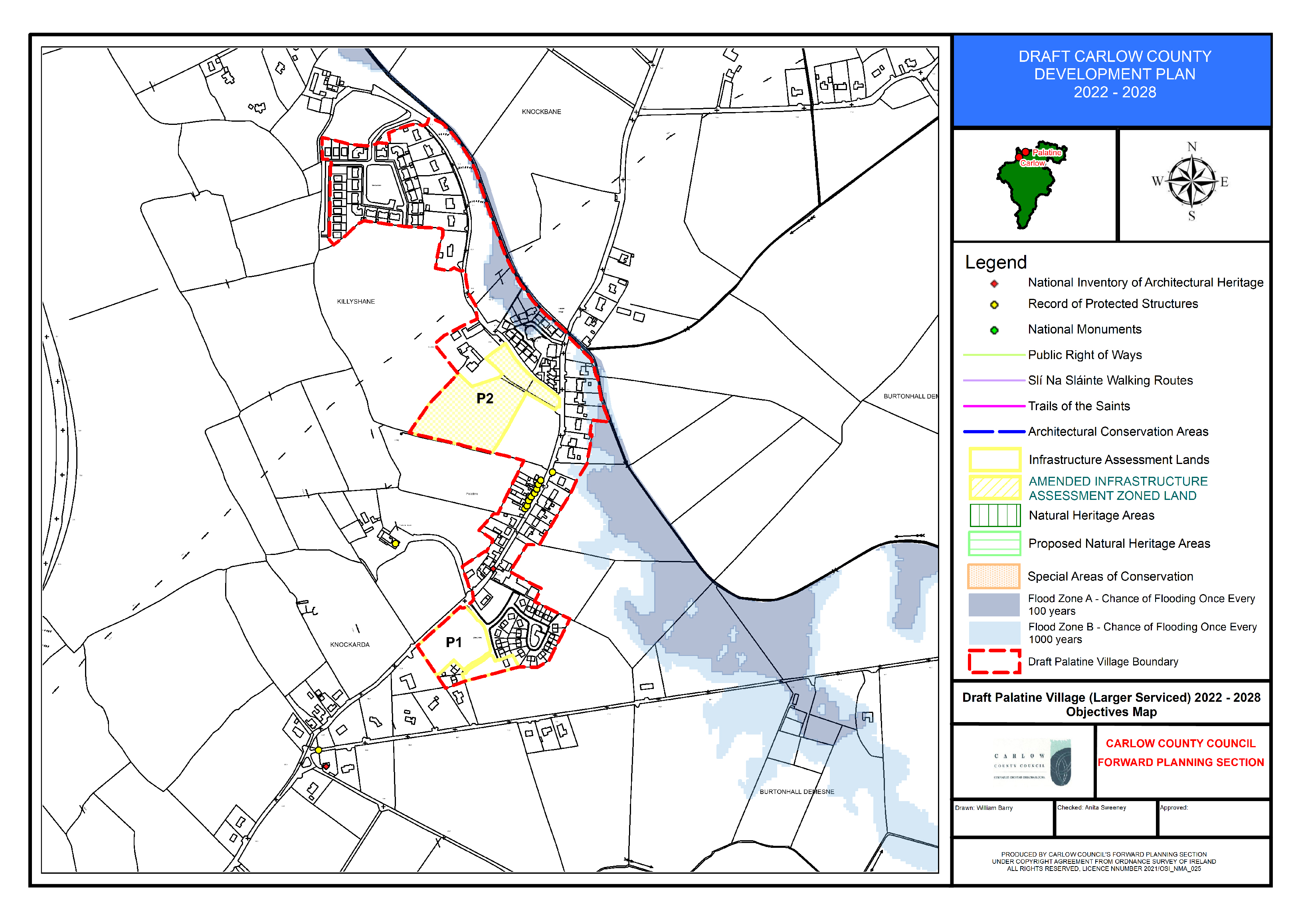
(Amendment No. 142) Amend Palatine Objectives Map to include additional sites for consideration as part of the Infrastructure Lands (Vol 2- Appendix X).
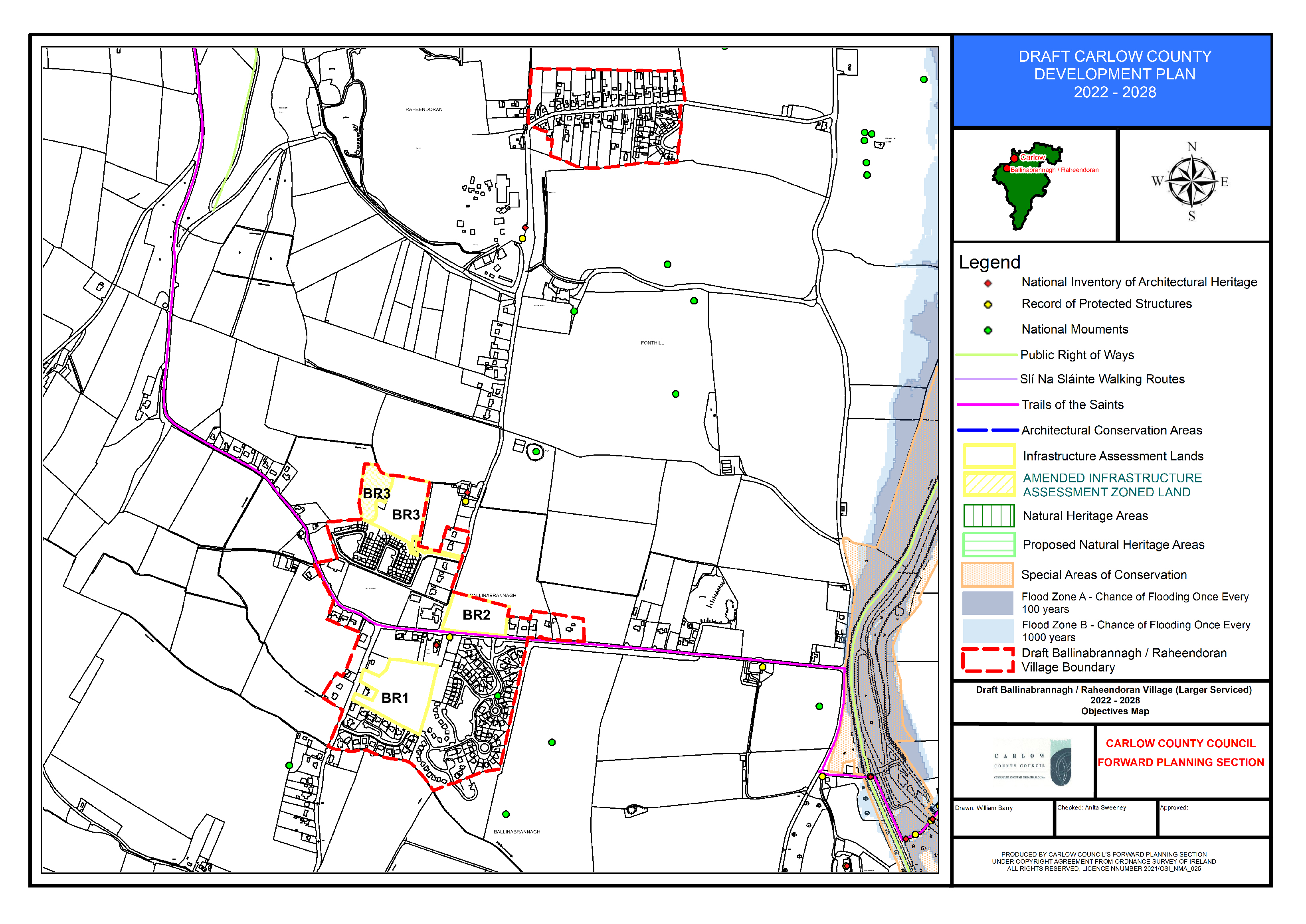
Section 15.4.2 Ballinabrannagh/Raheendoran
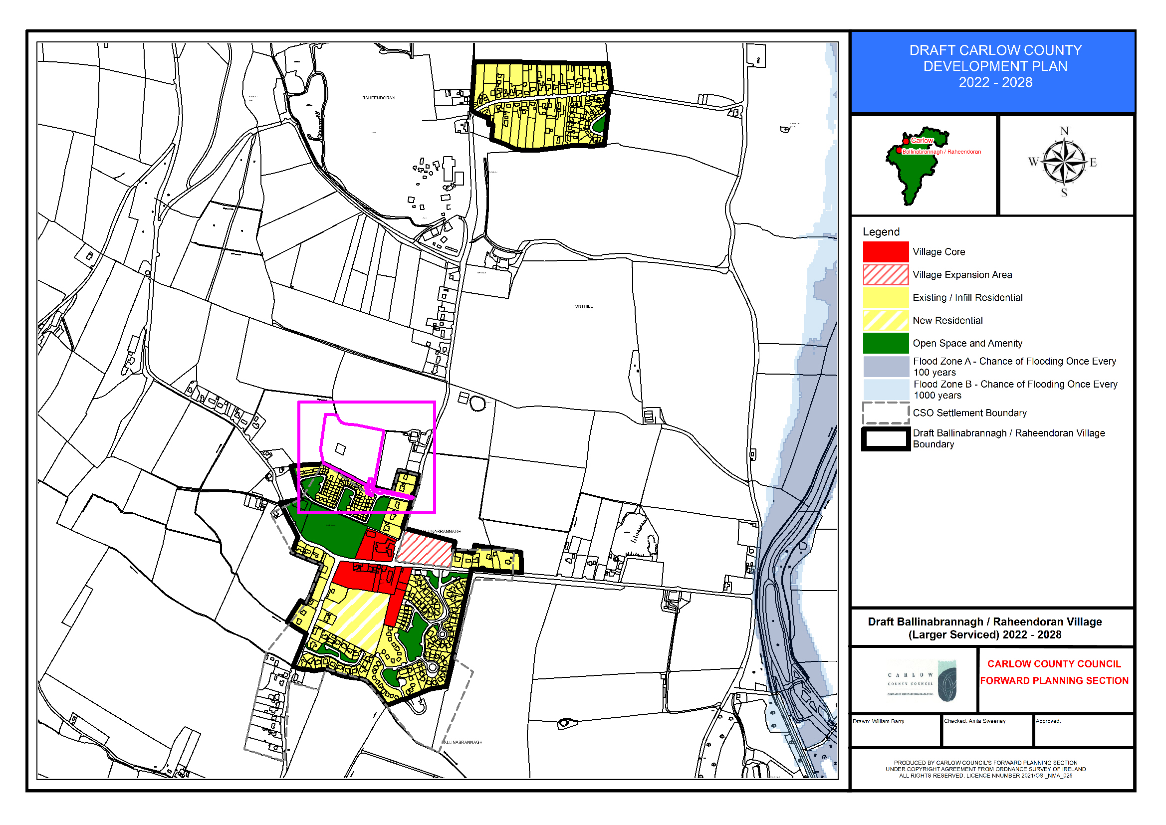
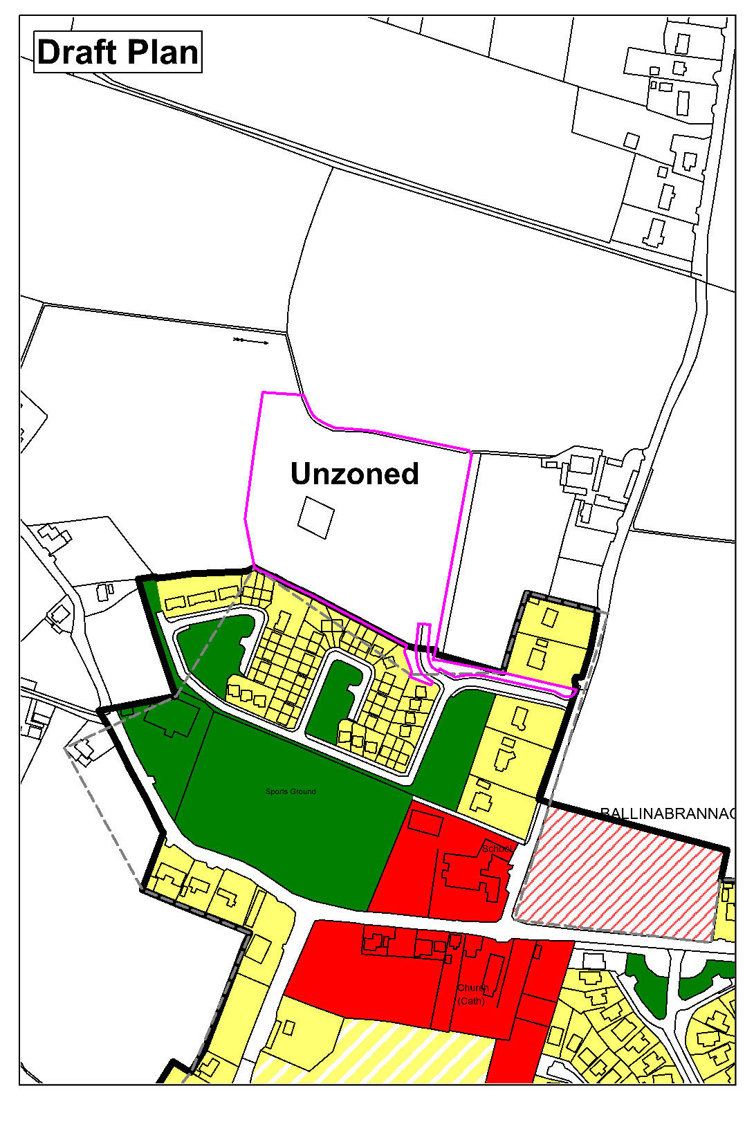
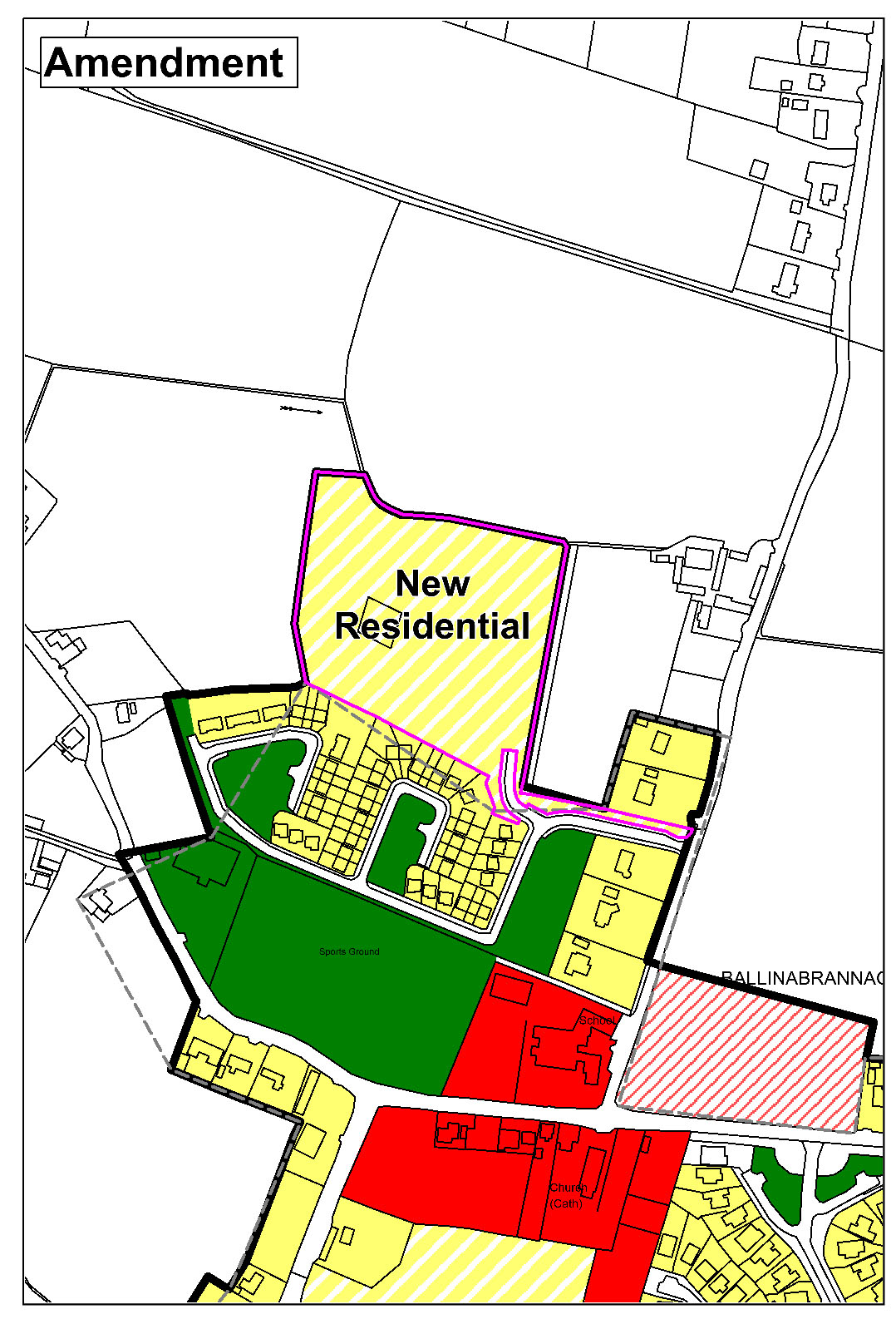
(Amendment No. 143) Amend Ballinabrannagh/Raheendoran Plan Land Use Zoning Map to extend village boundary and zone land ‘New Residential’, with corresponding specific objective that It is an objective of the Council to consider the provision of a maximum of 22 no. residential units, subject to the appropriate phasing of the scheme and high-quality design and siting considerations, which will provide for an integrated development including pedestrian permeability through the site to the existing adjoining development. The scheme shall also provide high-quality landscaping and public open space provision and shall comply all other proper planning and sustainable development considerations as appropriate.
|
|
(Amendment No. 144) Amend Ballinabrannagh Objectives Map to include additional sites / proposed residential zoning(s) for consideration as part of the Infrastructure Lands (Vol 2- Appendix X).
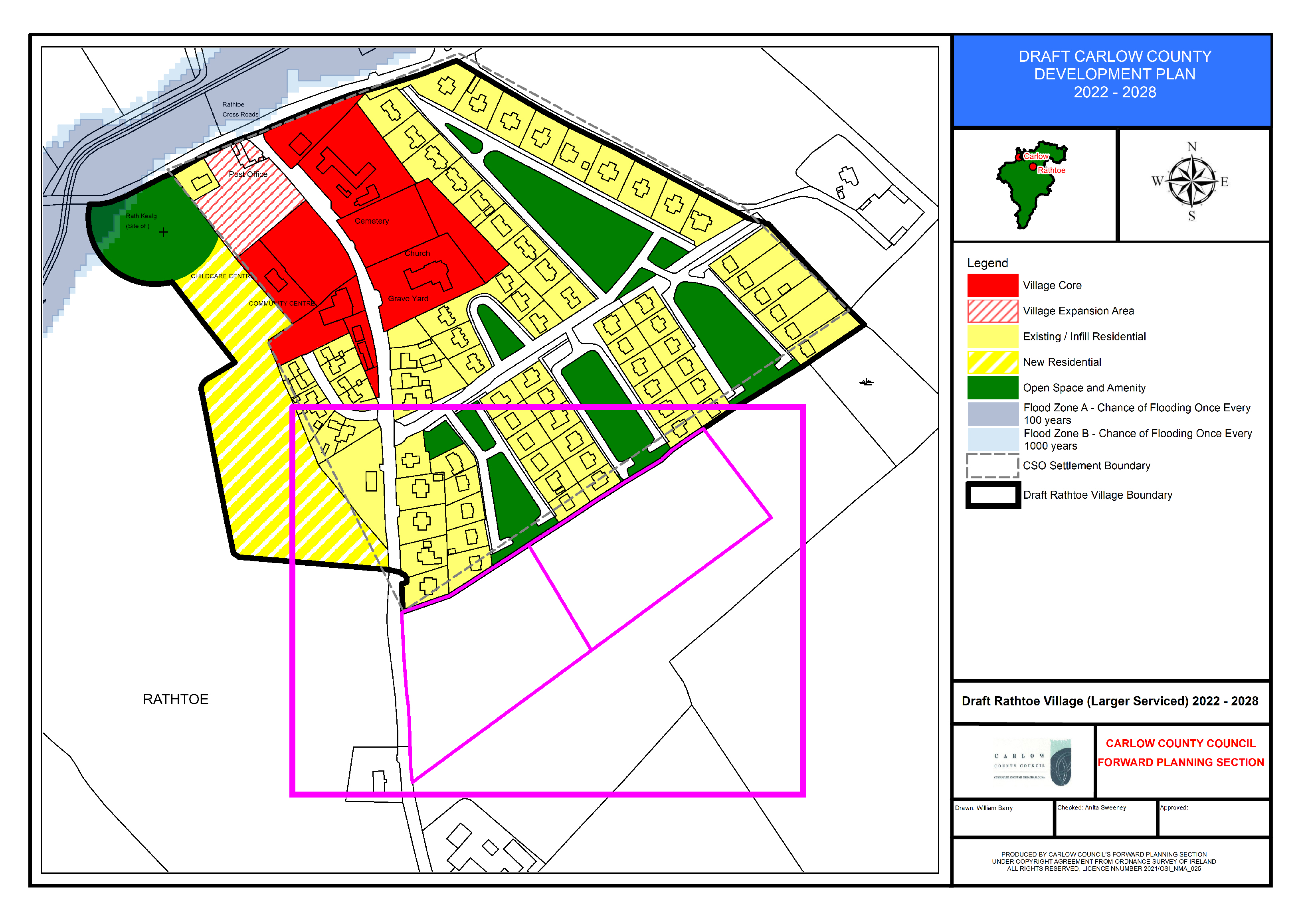
Section 15.4.3 Rathoe
(Amendment no. 145) Insert new policy under Section 15.4.3, new text in green as follows:
Flood Risk Management
RT. P16: Manage flood risk in Rathoe in accordance with the following provisions:
New highly vulnerable development is only appropriate within Flood Zone C. New less vulnerable development is only appropriate within Flood Zone B/C. Any future development adjacent to the Flood Zones should be subject to an FRA which must follow the general guidance provided in Section 6 of the SFRA and specifically address the following:
- Existing flood data is indicative and does not provide flood levels. An appropriately detailed hydraulic model will be required to confirm flood levels and extents.
- FRA should address climate change scenarios in relation to FFLs and potential mitigation measures;
- Finished floor levels should be above the 1% AEP level plus climate change and freeboard;
- Emergency evacuation plan and defined access / egress routes should be developed for extreme flood events.
- Any development shall also be required to be built in accordance with Carlow County Council SuDS Policy.
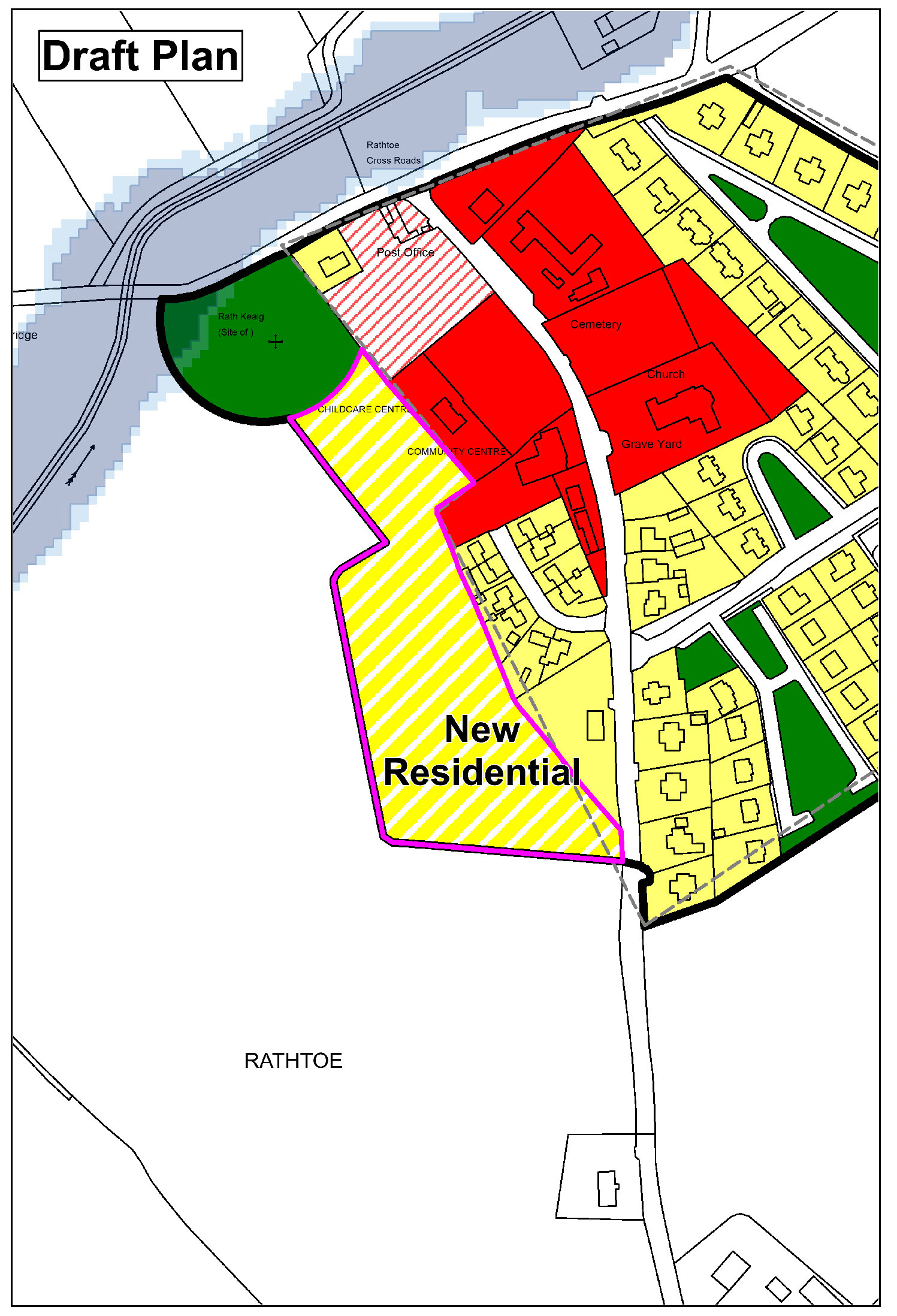
(Amendment No. 146) Amend Rathoe Land Use Zoning Map to extend village boundary and zone land (2ha) ‘New Residential’ and land (2ha) ‘Strategic Reserve’.
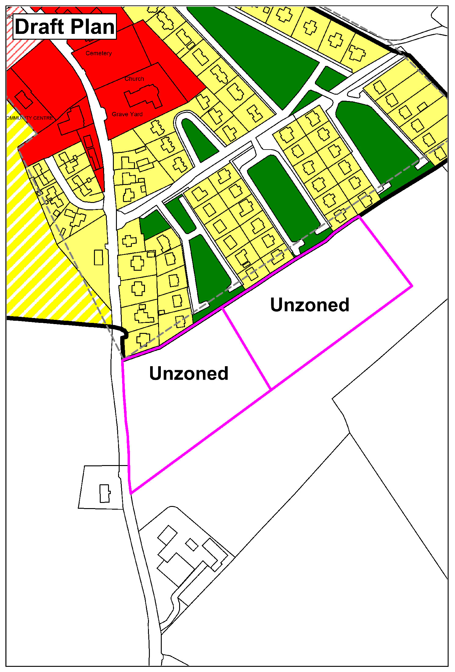
|
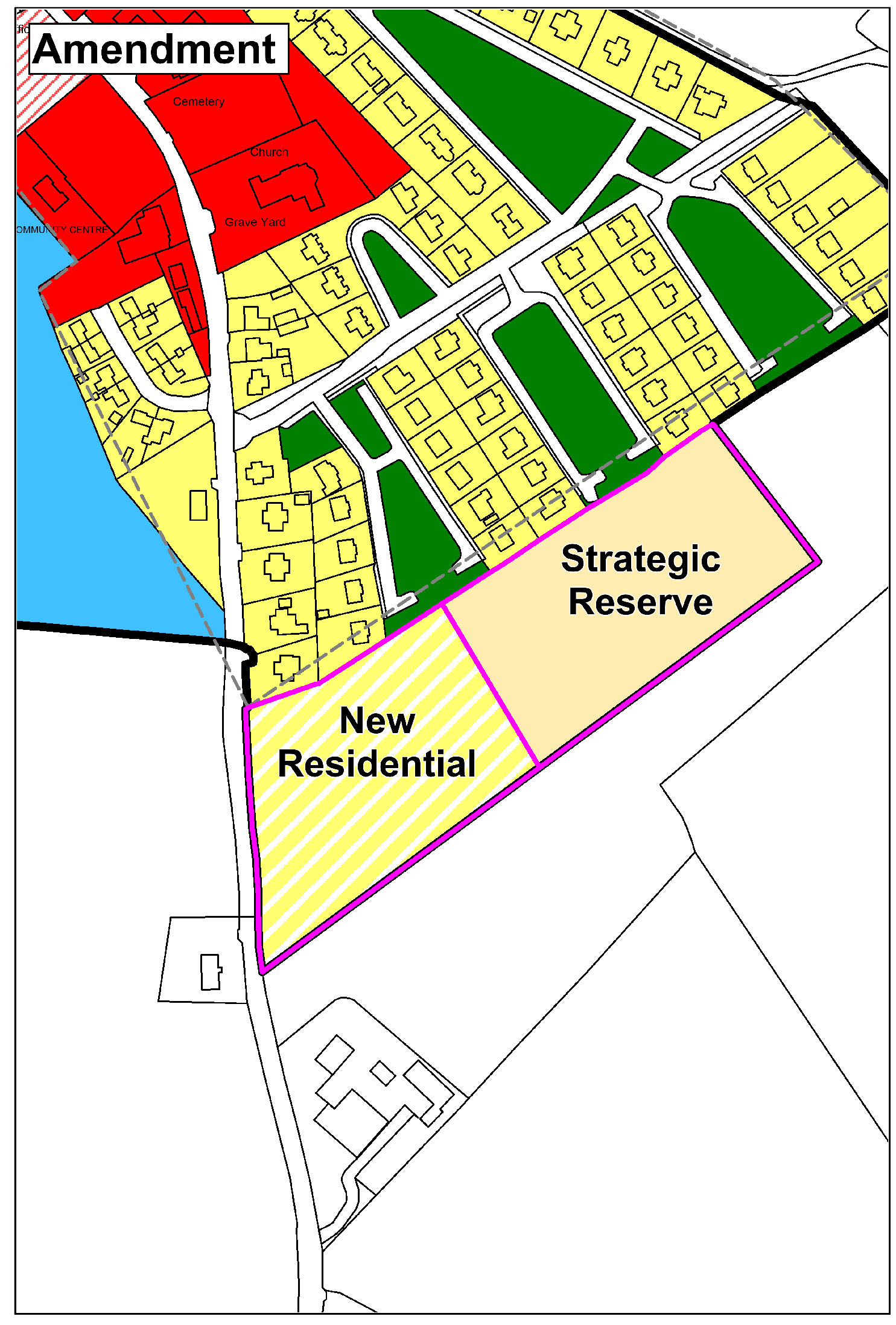
|
(Amendment No. 147) Amend Rathoe Land Use Zoning Map to rezone land from ‘New Residential’ to ‘Community/Education’

|
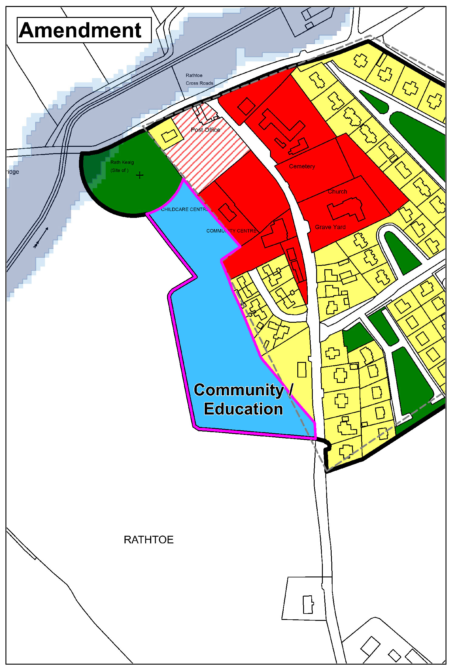
|
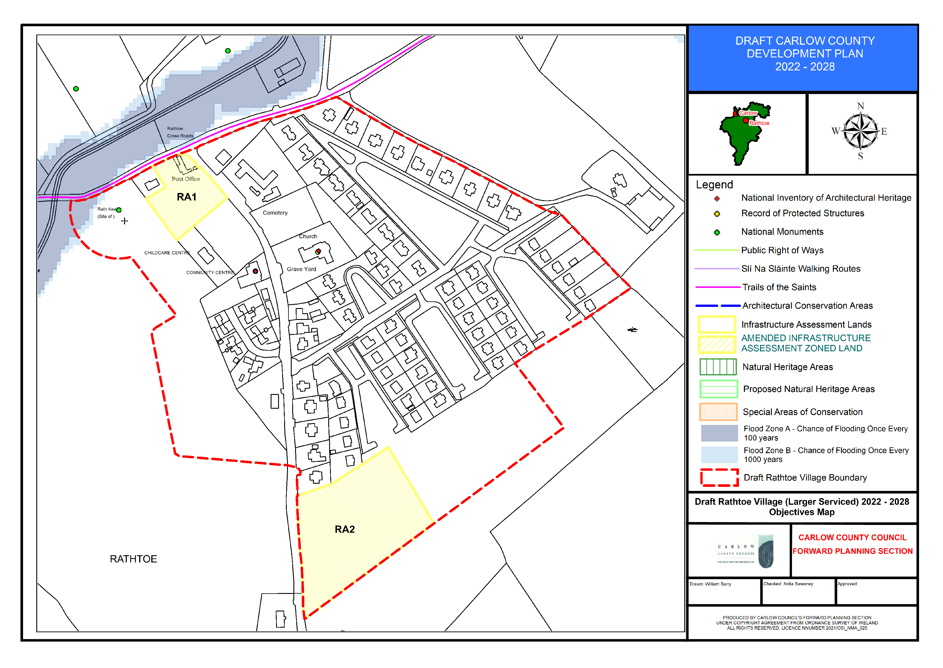
(Amendment No. 148) Amend Rathtoe Objectives Map to include additional sites / proposed residential zoning(s) for consideration as part of the Infrastructure Lands (Vol 2- Appendix X).
Section 15.4.4 Fennagh
(Amendment No. 149) Insert new policy under Section 15.4.4, new text in green as follows:
Flood Risk Management
FN. P16: Manage flood risk in Fennagh in accordance with the following provisions:
1.For areas zoned existing residential within the Woodglade Estate within Flood Zone A and B, development shall be:
- Limited to extensions, renovations and change of use; and,
- Infill residential development and demolition and reconstruction can only take place in Flood Zone C.
Any future development should be subject to an FRA which should follow the general guidance provided in Section 6 of the SFRA and must specifically address the following:
- Existing flood data is indicative and does not provide flood levels. An appropriately detailed hydraulic model will be required to confirm flood levels and extents;
- The sequential approach should be applied, and highly vulnerable infill and redevelopment shall not be permitted in Flood Zone A or B;
- FRA should address climate change scenarios in relation to FFLs and potential mitigation measures;
- Finished floor levels should be above the 1% AEP level plus climate change and freeboard;
- Bedrooms should be located in the upstairs of two-storey buildings when extending existing property;
- Flood resilient construction materials and fittings should be considered if in Flood Zone A/B;
- Proposals should not impede existing flow paths or cause flood risk impacts to the surrounding areas;
- Emergency evacuation plan and defined access / egress routes should be developed for extreme flood events; and,
- Any development shall also be required to be built in accordance with Carlow County Council SuDS Policy.
2. For part of the Village Core lands to the east of the R724 located within Flood Zone A and Flood Zone B. Any future expansion of the WWTP should be subject to an FRA, it would not be appropriate to place residential or other highly vulnerable use in the Village Core lands. Any future FRA should follow the general guidance provided in Section 6 of the SFRA and must specifically address the following:
- Existing flood data is indicative and does not provide flood levels. An appropriately detailed hydraulic model will be required to confirm flood levels and extents;
- The sequential approach should be applied and highly vulnerable elements of the site should be located in Flood Zone C, or raised/bunded/protected;
- FRA should address climate change scenarios in relation to operational levels and potential mitigation measures;
- Proposals should not impede existing flow paths or cause flood risk impacts to the surrounding areas, and;
- Emergency evacuation plan and defined access / egress routes should be developed for extreme flood events; and,
- Any development shall also be required to be built in accordance with Carlow County Council SuDS Policy.
3. Parts of the Creche and Church site are located within Flood Zone A/B. Any future expansion of the creche should be subject to an FRA which should follow the general guidance provided in Section 6 of the SFRA and must specifically address the following:
- Existing flood data is indicative and does not provide flood levels. An appropriately detailed hydraulic model will be required to confirm flood levels and extents;
- The sequential approach should be applied and highly vulnerable elements of the site should be located in Flood Zone C, or raised/bunded/protected;
- Flood Zone A/B would principally be suitable for playing pitches/water compatible use only;
- FRA should address climate change scenarios in relation to operational levels and potential mitigation measures;
- Proposals should not impede existing flow paths or cause flood risk impacts to the surrounding areas;
- Emergency evacuation plan and defined access / egress routes should be developed for extreme flood events; and
- Any development shall also be required to be built in accordance with Carlow County Council SuDS Policy.
The Church lands adjacent/within the Flood Zone are used as a burial ground. A groundwater impact assessment may be advisable for the lower lying part of the site adjacent/within the Flood Zones to ensure groundwater is not negatively impacted.
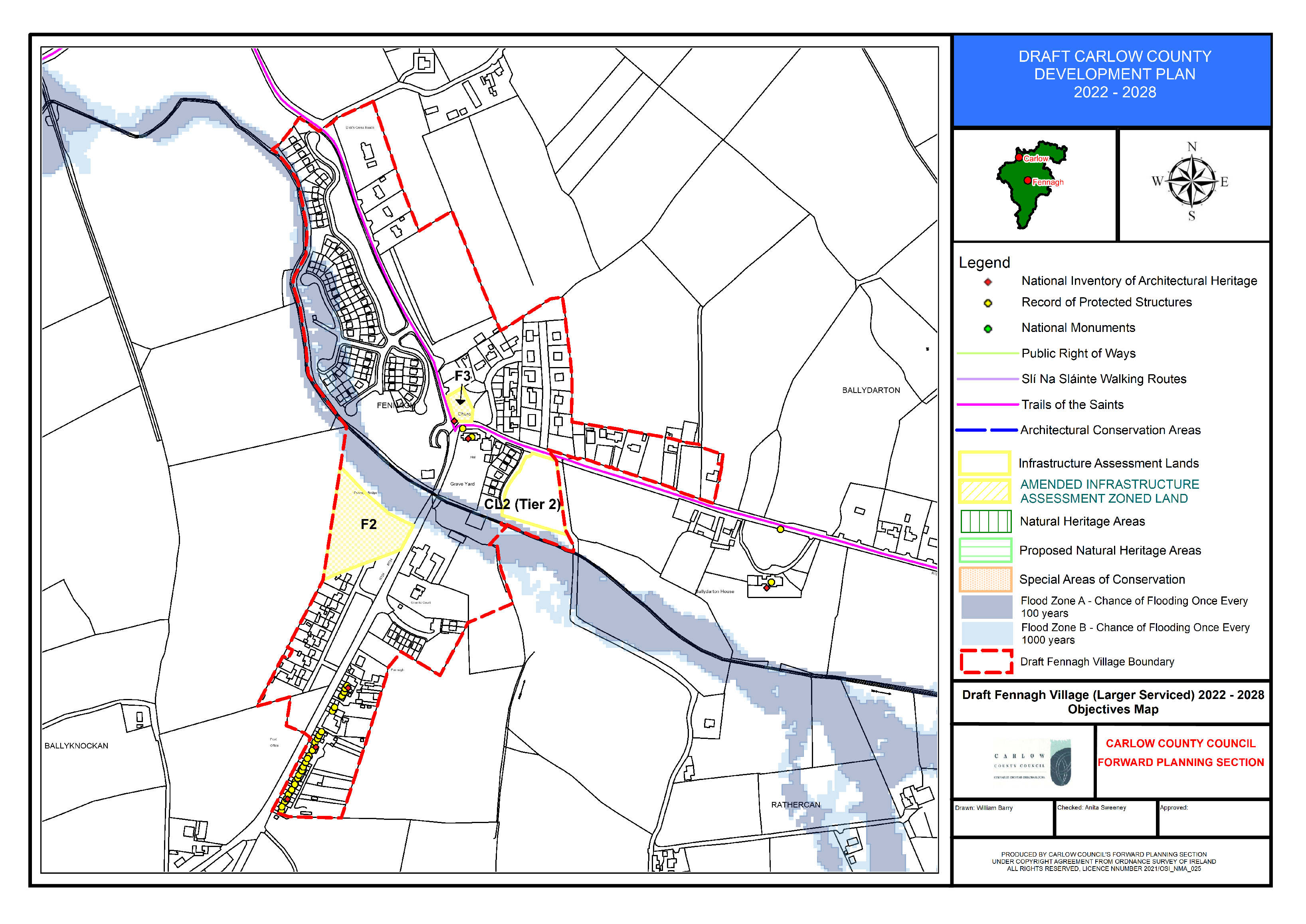
(Amendment No. 150) Amend Fennagh Objectives Map to include additional sites for consideration as part of the Infrastructure Lands (Vol 2- Appendix X).
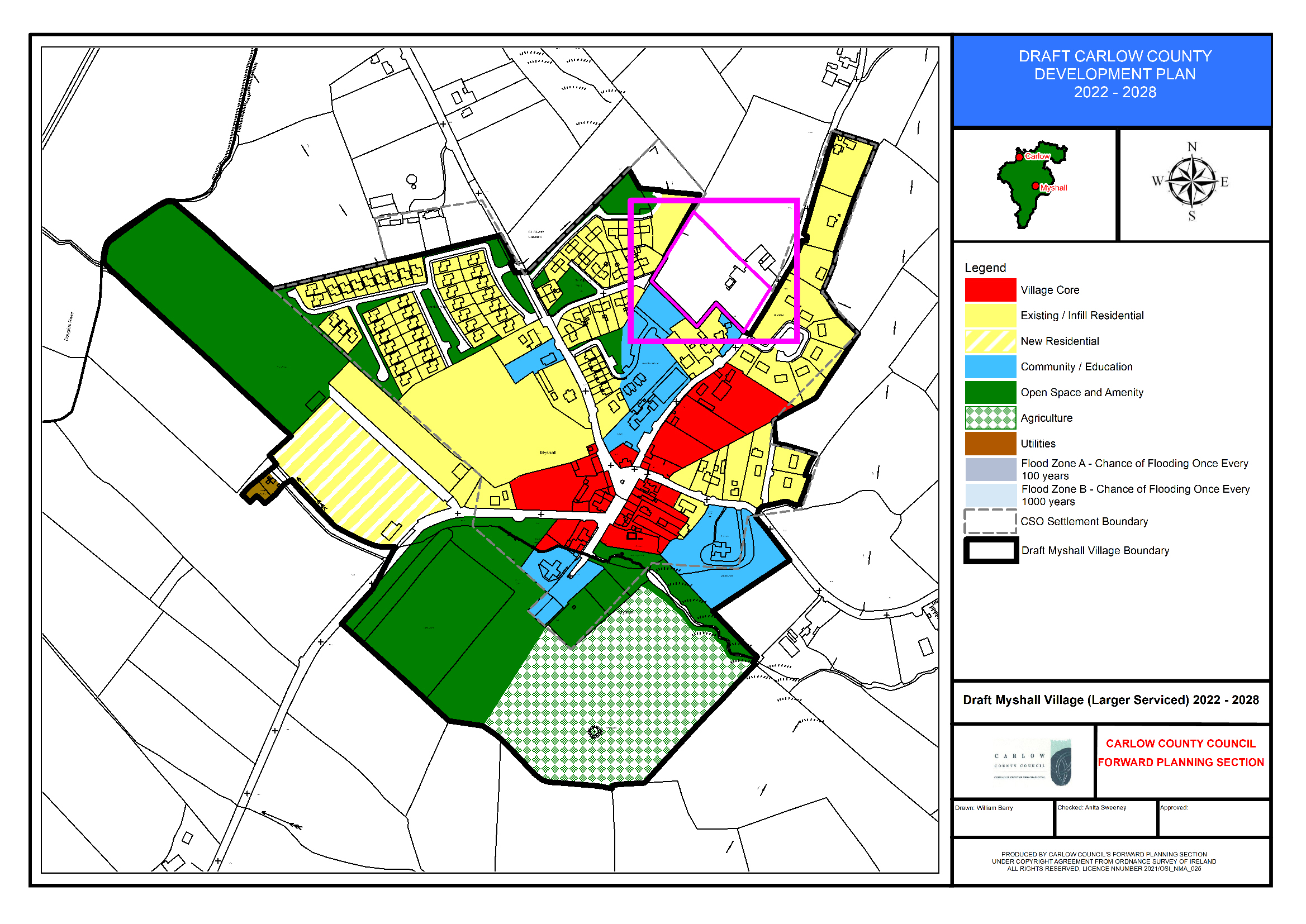
Section 15.4.5 Myshall
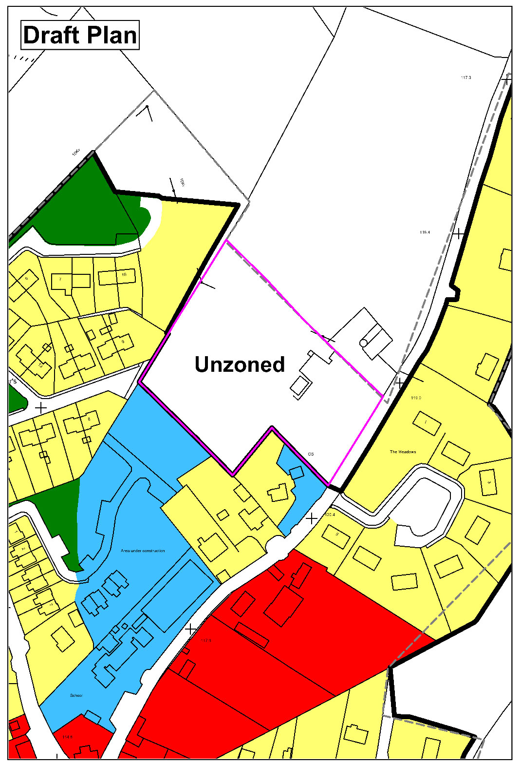
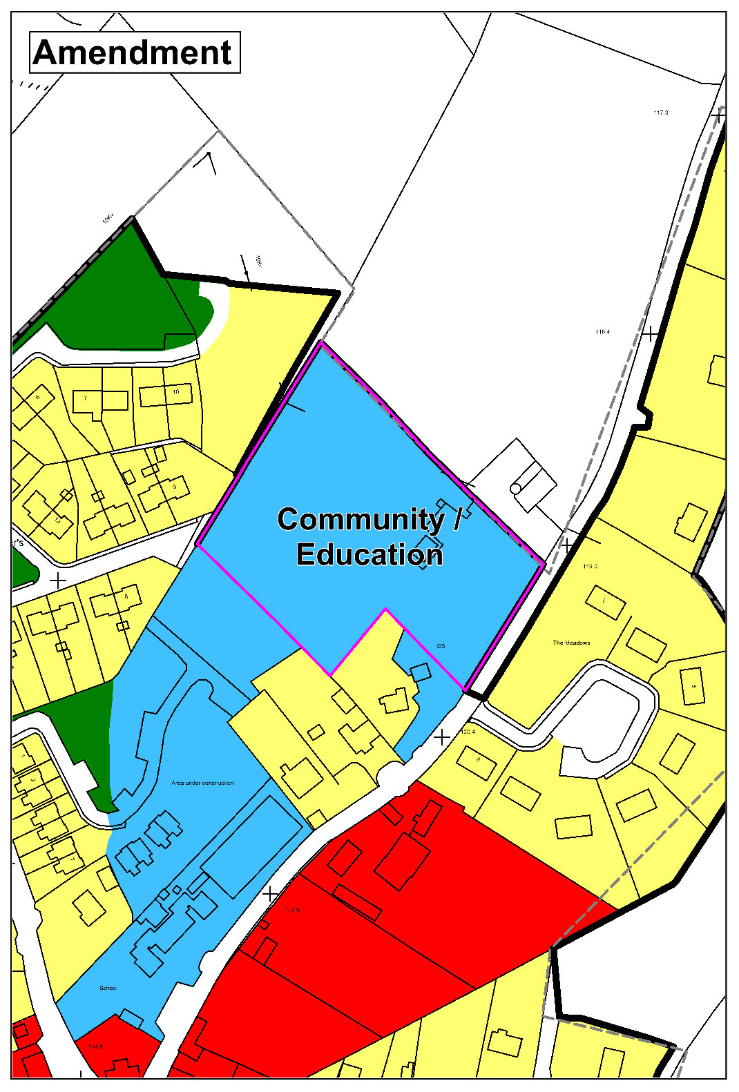
(Amendment No. 151) Amend Myshall Land Use Zoning Map to extend village boundary and zone land ‘Community/Education’.
|
|
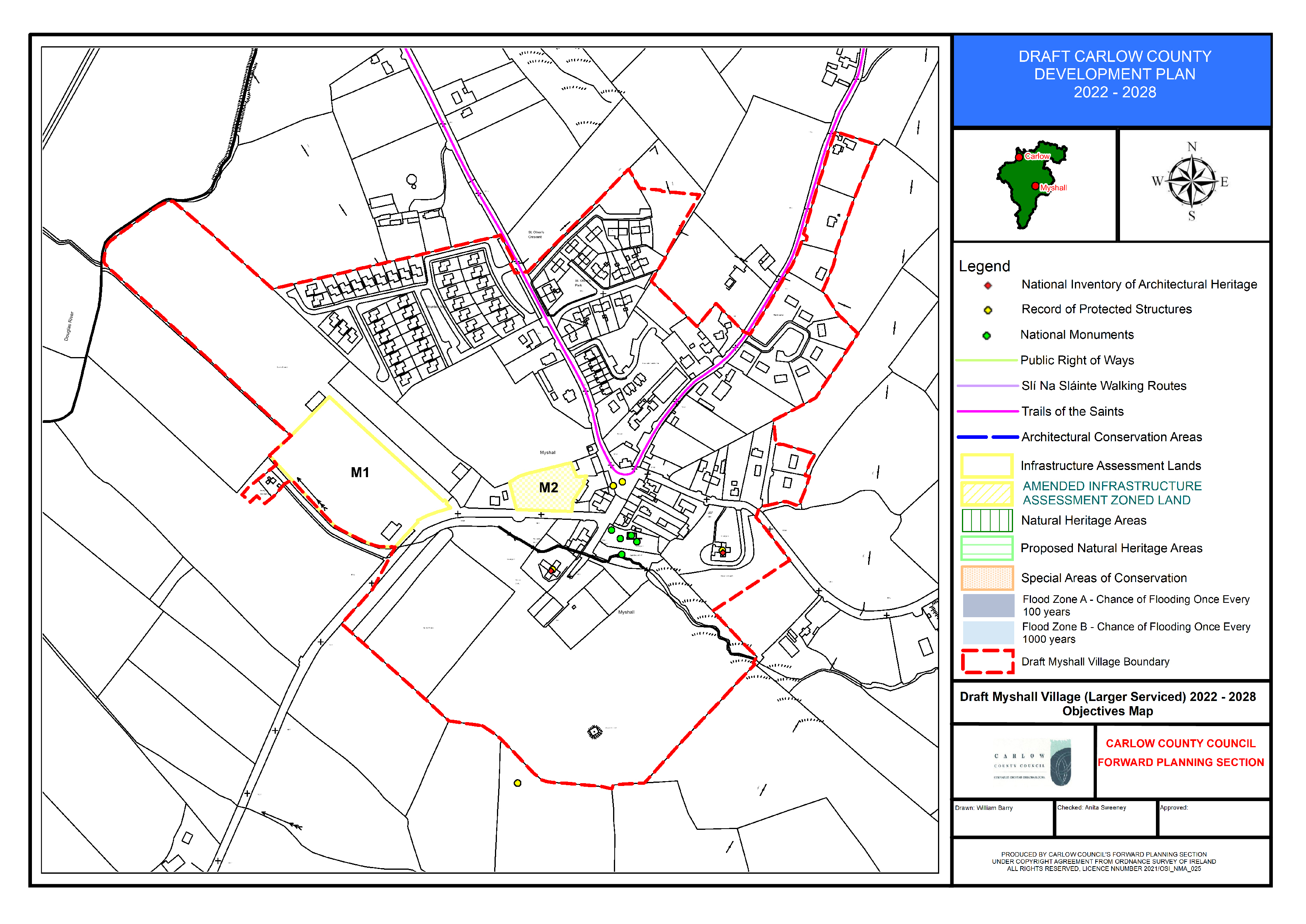
(Amendment No. 152) Amend Myshall Objectives Map to include additional sites for consideration as part of the Infrastructure Lands (Vol 2- Appendix X).
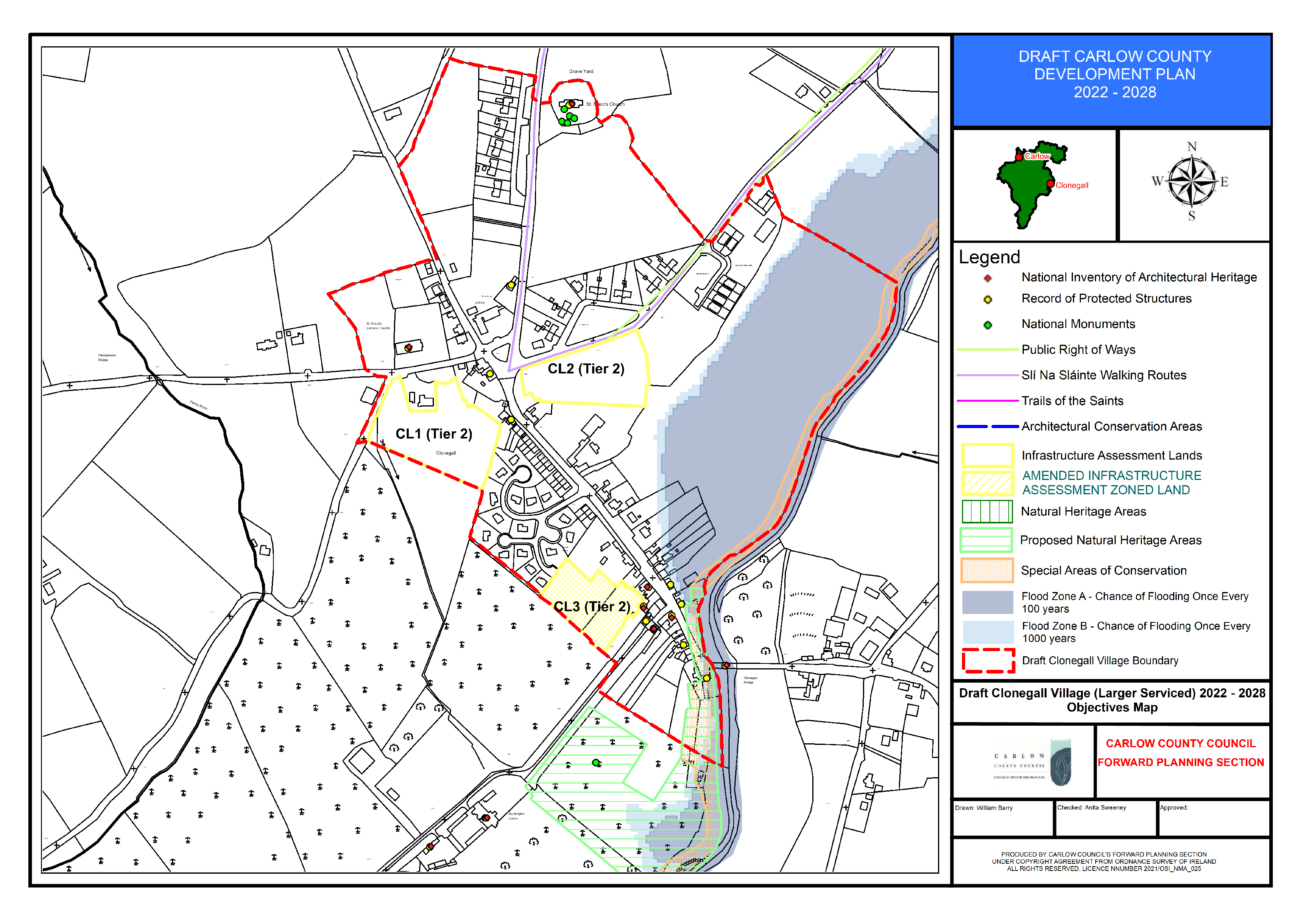
Section 15.4.6 Clonegall
(Amendment No. 153) Insert new policy under Section 15.4.6, new text in green as follows:
Flood Risk Management
CG. P19: Manage flood risk on part of the village core lands to the east of the L2021 within Flood Zone A and B in Clonegal in accordance with the following provisions:
Development shall be:
- Limited to extensions, renovations and change of use; and,
- Infill residential development and demolition and reconstruction can only take place in Flood Zone C.
Any future development should be subject to an FRA which should follow the general guidance provided in Section 6 of the SFRA and must specifically address the following:
- Existing flood data is indicative and does not provide flood levels. An appropriately detailed hydraulic model will be required to confirm flood levels and extents;
- The sequential approach should be applied, and highly vulnerable infill and redevelopment shall not be permitted in Flood Zone A or B;
- FRA should address climate change scenarios in relation to FFLs and potential mitigation measures;
- Finished floor levels should be above the 1% AEP level plus climate change and freeboard;
- The residual risk of bridge blockage should be investigated;
- Bedrooms should be located in the upstairs of two-storey buildings when extending existing property in Flood Zone A/B;
- Flood resilient construction materials and fittings should be considered if in Flood Zone A/B;
- Proposals should not impede existing flow paths or cause flood risk impacts to the surrounding areas;
- Emergency evacuation plan and defined access / egress routes should be developed for extreme flood events; and,
- Any development shall also be required to be built in accordance with Carlow County Council SuDS Policy.
(Amendment No. 154) Amend Clonegall Objectives Map to include additional sites for consideration as part of the Infrastructure Lands (Vol 2- Appendix X).
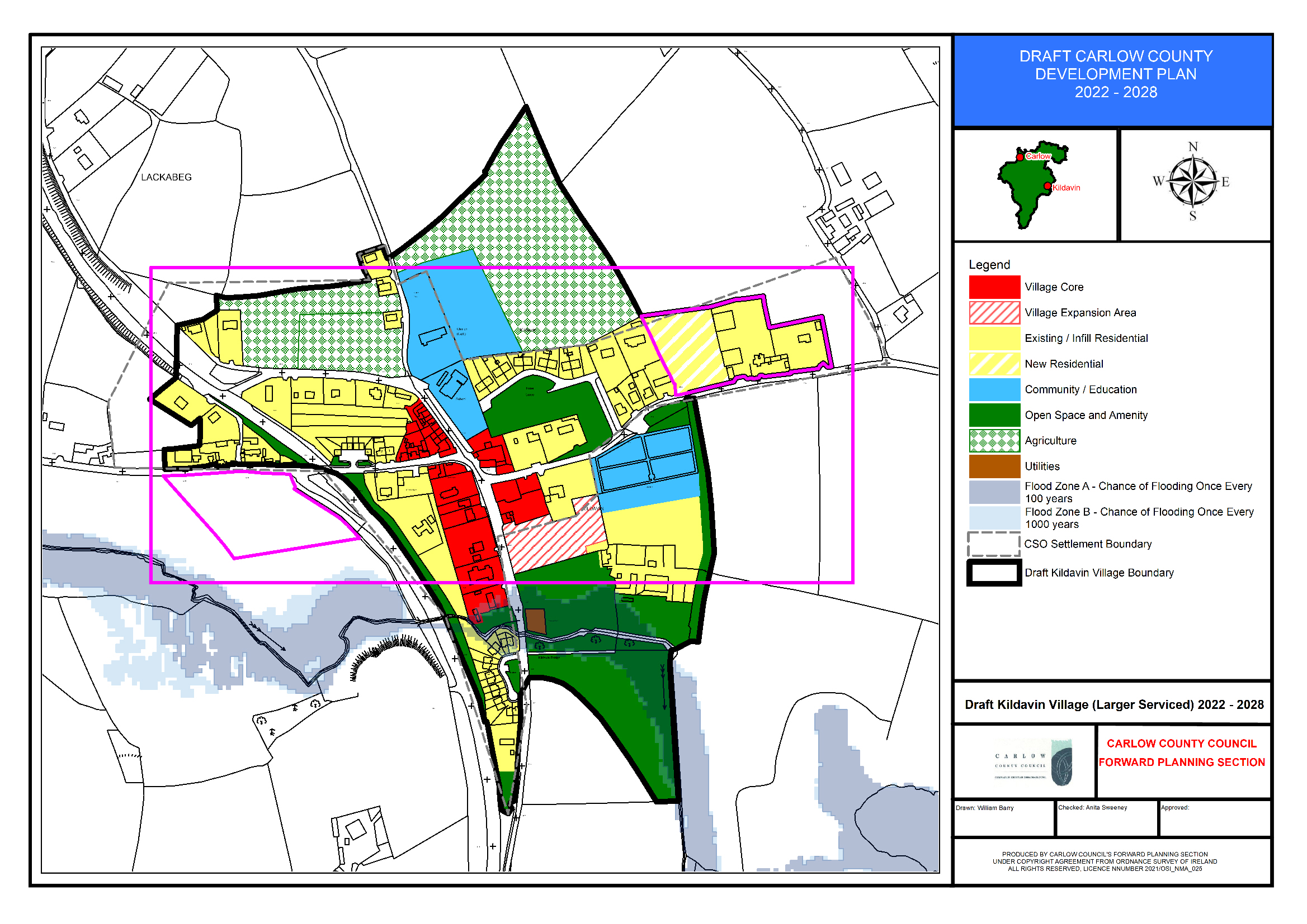
Section 15.4.7 Kildavin
(Amendment No. 155) Insert new policy under Section 15.4.6, new text in green as follows:
Flood Risk Management
KD. P17: Manage flood risk in Kildavin in accordance with the following provisions:
1.Village Core and utilities lands to the East and West of the R724 within Flood Zone A and B shall comply with the following provisions:
Any future expansion of the WWTP or Childcare facility Village Core and Utilities Lands should be subject to an FRA which should follow the general guidance provided in Section 6 of the SFRA and must specifically address the following:
- Existing flood data is indicative and does not provide flood levels. An appropriately detailed hydraulic model will be required to confirm flood levels and extents;
- The sequential approach should be applied, and highly vulnerable elements of the site should be located in Flood Zone C, or raised/bunded/protected;
- FRA should address climate change scenarios in relation to operational levels and potential mitigation measures;
- Proposals should not impede existing flow paths or cause flood risk impacts to the surrounding areas; and,
- Emergency evacuation plan and defined access / egress routes should be developed for extreme flood events.
- Any development shall also be required to be built in accordance with Carlow County Council SuDS Policy.
2. Areas of the existing residential zoning within the Glasheen Estate within Flood Zone A and Flood Zone B shall comply with the following provisions:
Development shall be;
- Limited to extensions, renovations and change of use; and,
- Infill residential development and demolition and reconstruction can only take place in Flood Zone C.
Any future development should be subject to an FRA which should follow the general guidance provided in Section 6 of the SFRA and must specifically address the following:
- Existing flood data is indicative and does not provide flood levels. An appropriately detailed hydraulic model will be required to confirm flood levels and extents;
- The sequential approach should be applied, and highly vulnerable infill and redevelopment shall not be permitted in Flood Zone A or B;
- FRA should address climate change scenarios in relation to FFLs and potential mitigation measures;
- Finished floor levels should be above the 1% AEP level plus climate change and freeboard;
- Bedrooms should be located in the upstairs of two-storey buildings when extending existing property;
- Flood resilient construction materials and fittings should be considered if in Flood Zone A/B;
- Proposals should not impede existing flow paths or cause flood risk impacts to the surrounding areas;
- Emergency evacuation plan and defined access / egress routes should be developed for extreme flood events; and,
- Any development shall also be required to be built in accordance with Carlow County Council SuDS Policy.
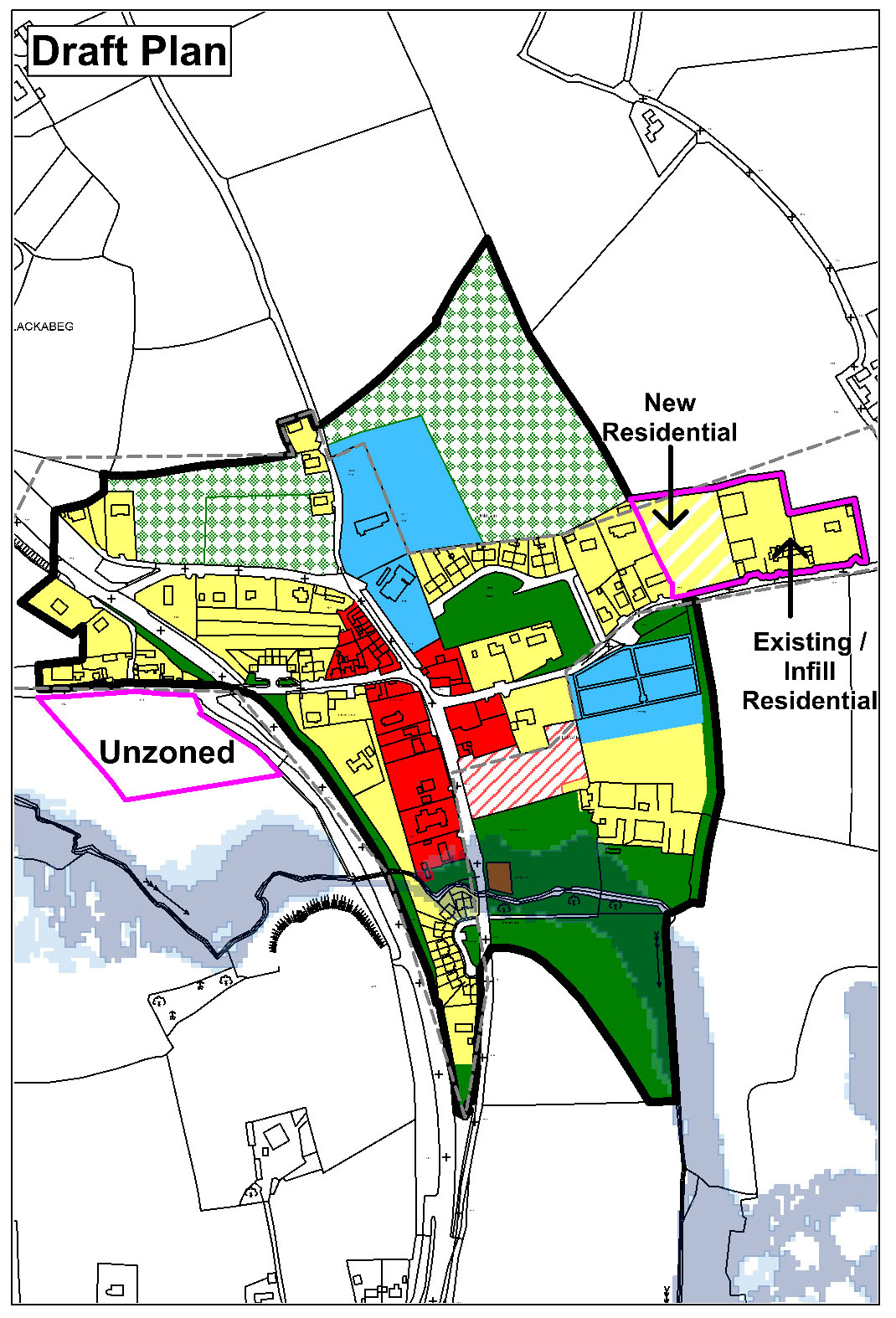
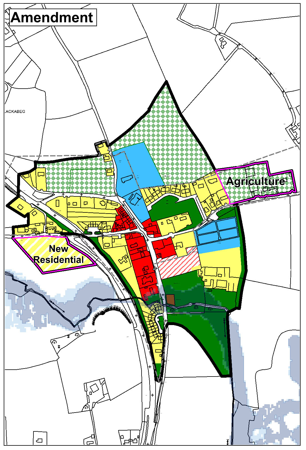
(Amendment No. 156) Amend Kildavin Land Use Zoning Map to rezone land from ‘New Residential’ and ‘Existing Residential/Infill’ to ‘Agriculture, and extend village boundary to zone land (1.5ha) ‘New Residential’ with corresponding specific objective It is an objective of the Council to facilitate low density residential development (max. no. 15 no. units) subject to high-quality design and siting considerations, which will provide for an integrated development, and which shall also provide high-quality landscaping and public open space provision and shall comply all other proper planning and sustainable development considerations as appropriate.
|
|
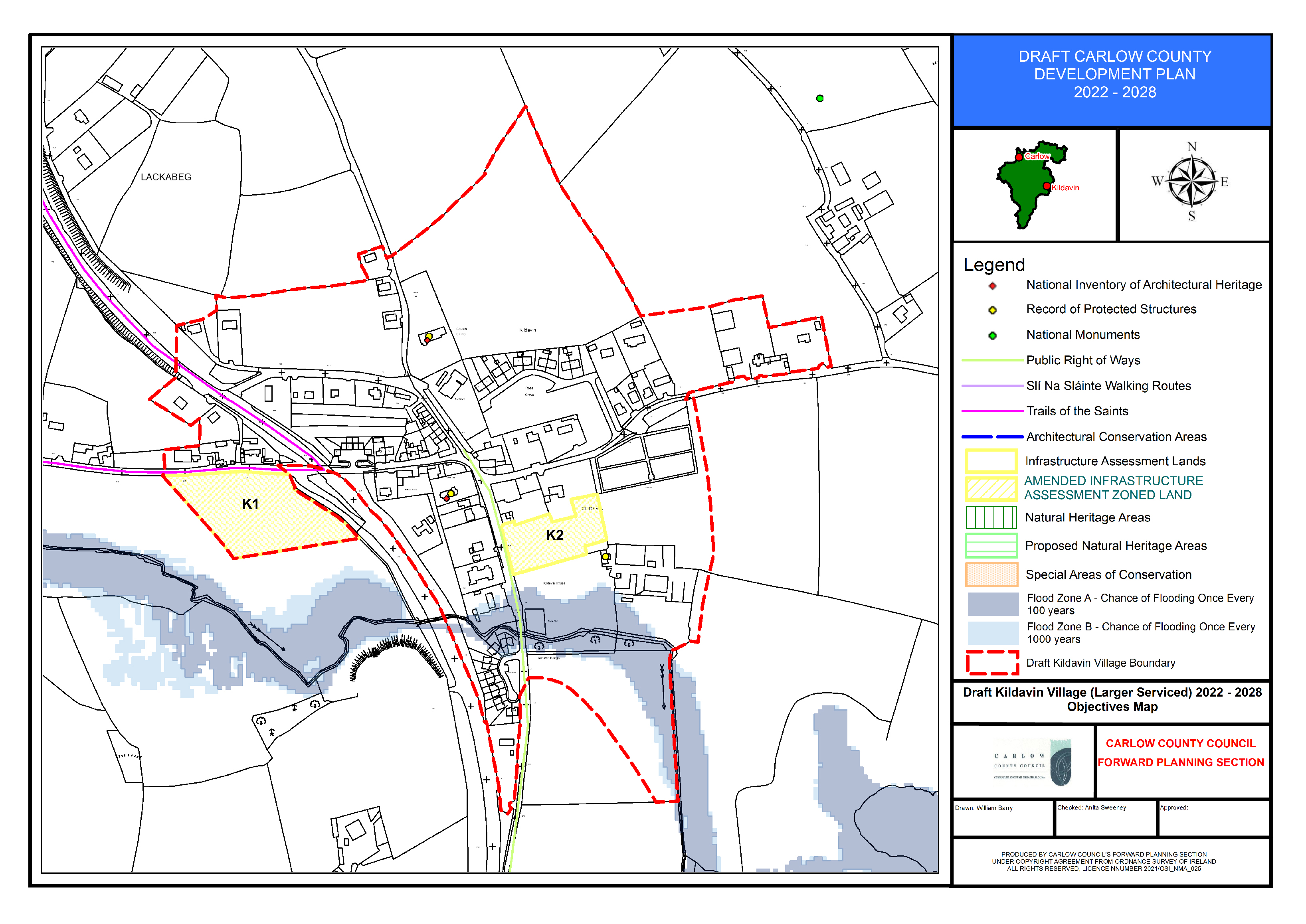
(Amendment No. 157) Amend Kildavin Objectives Map to include additional sites / proposed residential zoning(s) for consideration as part of the Infrastructure Lands (Vol 2- Appendix X).
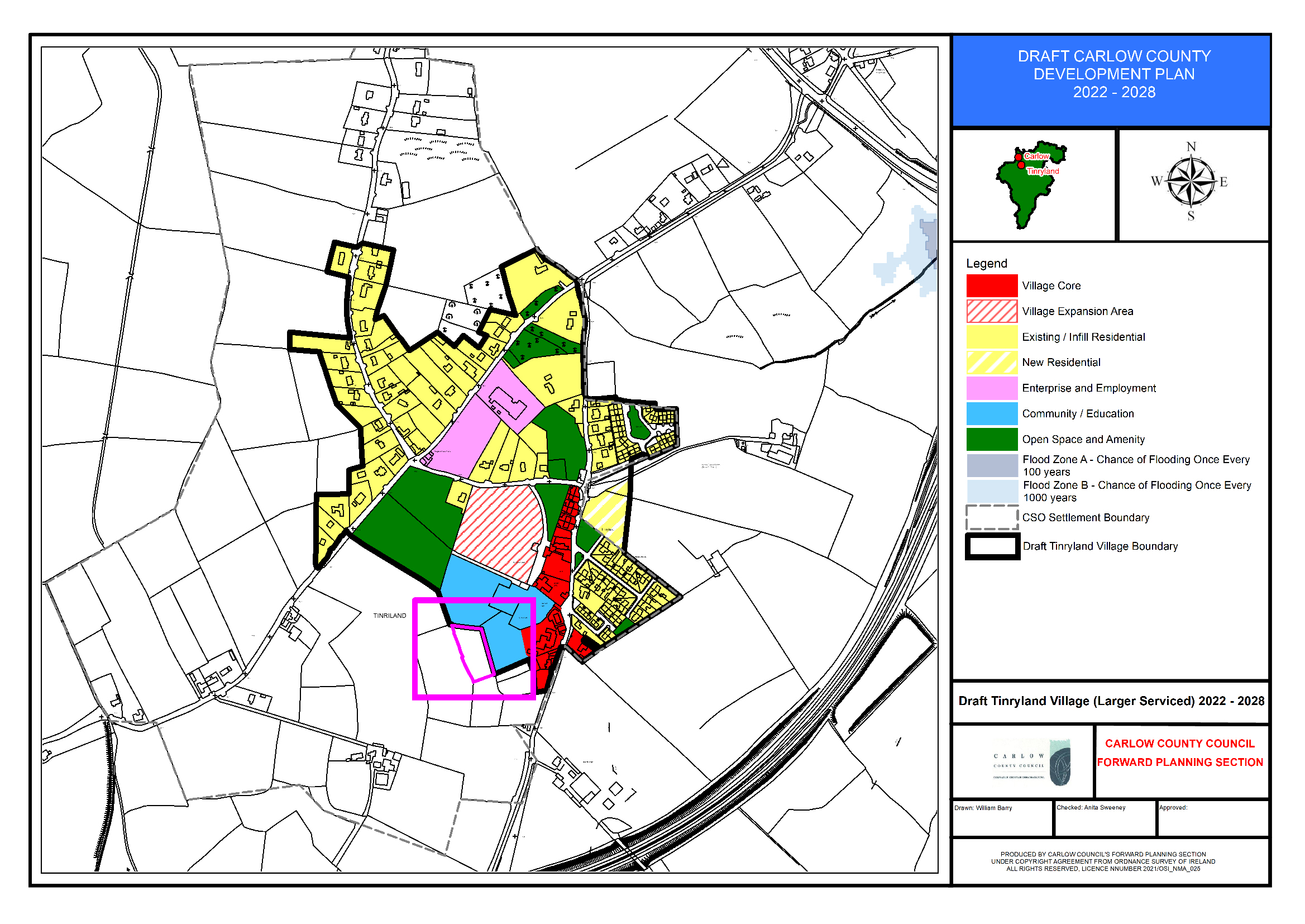
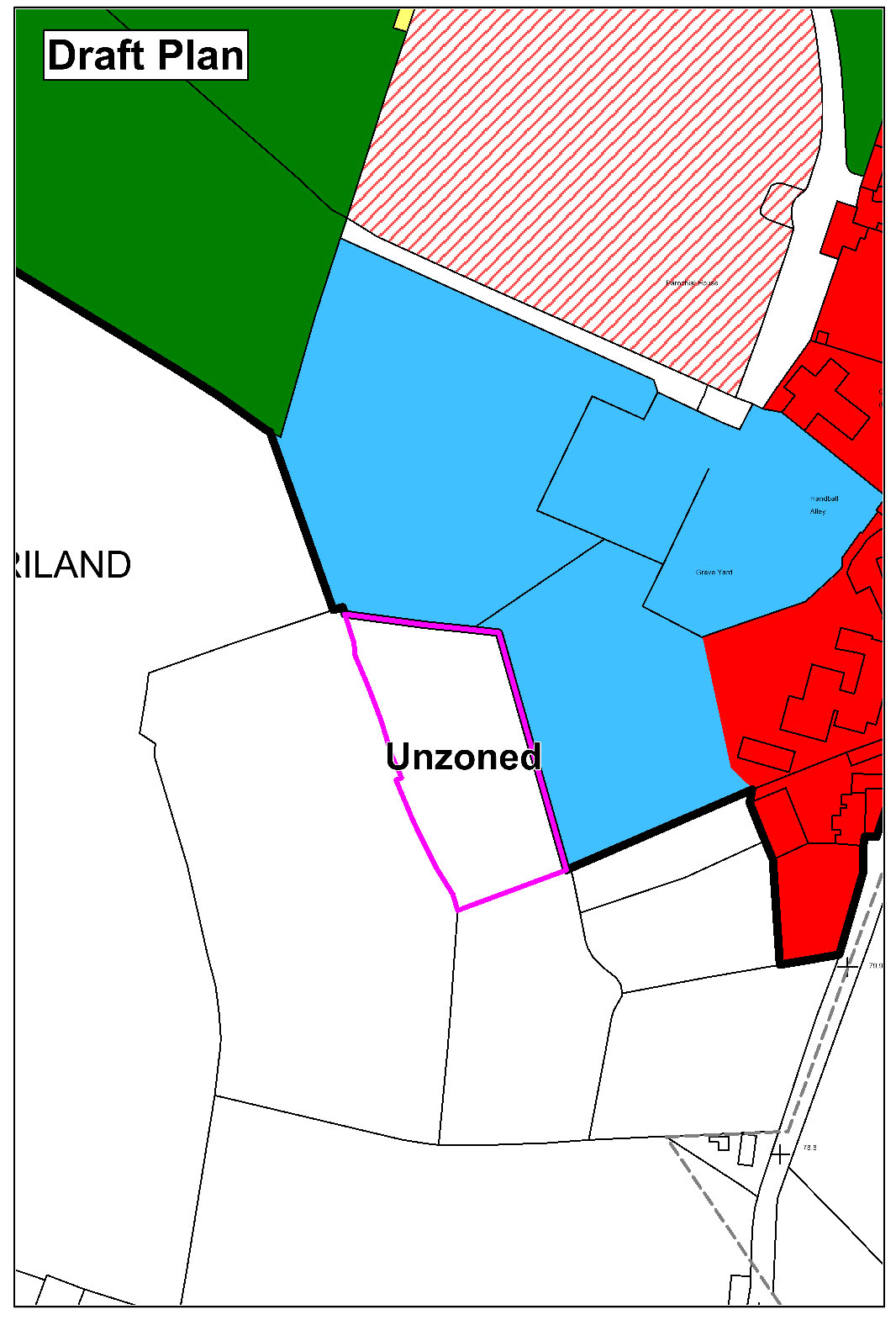
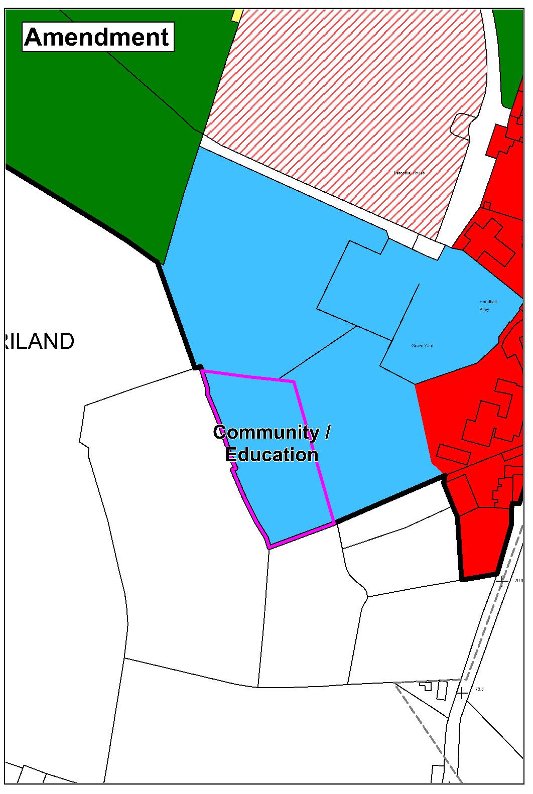
Section 15.4.8 Tinryland
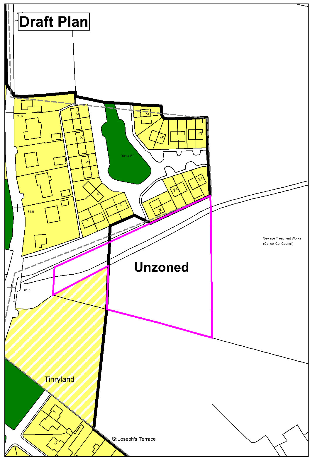
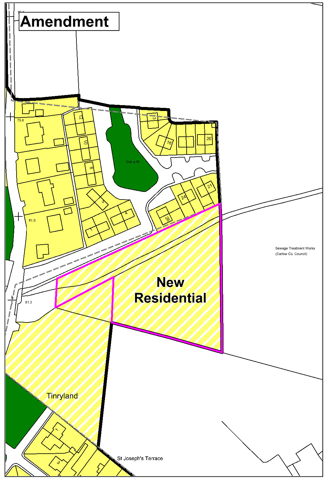
(Amendment No. 158) Amend Tinryland Land Use Zoning Map to extend the village boundary and zone land ‘New Residential’ (3 no. units on individual wastewater treatment systems).
|
|
(Amendment No. 159) Amend Tinryland Land Use Zoning Map to extend the village boundary and zone land ‘Community/Education’.
|
|
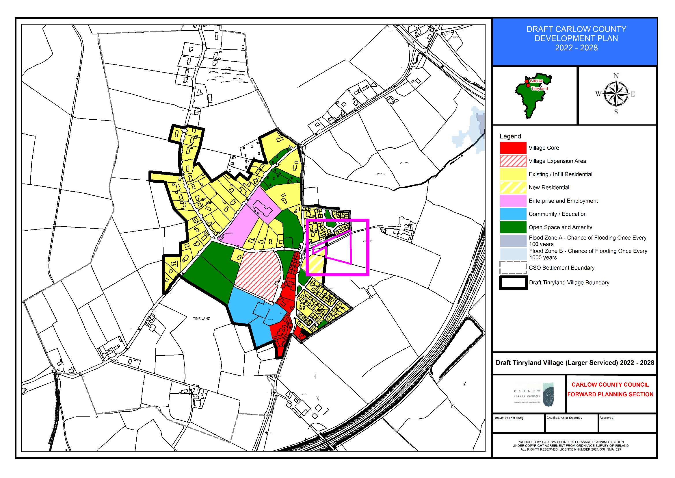
(Amendment No. 160) Amend Tinryland Objectives Map to include additional sites/ proposed residential zoning(s) for consideration as part of the Infrastructure Lands (Vol 2- Appendix X).
