Chapter 15: Leighlinbridge Plan
Vision
To seek to retain the natural and built heritage attributes of Leighlinbridge, to maximise opportunities afforded by its location on the River Barrow, to support the vitality and vibrancy of the town by consolidation of the town centre with an appropriate mix of uses, to promote tourism, regeneration and healthy placemaking while accommodating population growth, promoting employment opportunities and pursuing a continued pattern of high quality development that respects the inherent characteristics of the town.
15.3.2 Leighlinbridge Plan
15.3.2.1 Location and Context
Leighlinbridge is a scenic town located in the central west area of the County, c.12km south of Carlow Town and c.25km northeast of Kilkenny City. It has direct access to the R448 (former N9 Dublin-Waterford route) and is proximate to the M9 interchange at Junction 6 (Carlow South). The town is situated on the River Barrow and is traversed by the R705. The R705 links the town with Muinebheag/Royal Oak, 5km to the south. Prior to the town being bypassed in the 1980s, the N9 national primary route passed through Leighlinbridge.
The historic development of Leighlinbridge was greatly influenced by its importance as a transport and trade route via the River Barrow. Its strategic location on the river also gave rise to its ancient ecclesiastical and military importance as the most western Bastion of the Pale. The ruins of Black Castle now overlook the River Barrow.
|
Leighlinbridge |
|
|---|---|
|
Position in Settlement Hierarchy |
Small Town |
|
2016 Population |
914 |
|
2011 Population |
828 |
|
% Change 2011-2016 |
10% |
|
Households |
356 |
|
Committed Units not yet Built |
41 |
|
Core Strategy Housing Allocation |
99 |
|
Population Projection 2028 |
1,140 |
|
Architectural Conservation Areas |
No |
|
Protected Structures |
13 no. |
|
Zone of Archaeological Potential |
None |
|
Record of Monuments and Places (RMP) |
22 no. sites |
|
Natura 2000 Sites |
River Barrow and River Nore Special Area of Conservation (SAC). |
|
Water Services Infrastructure / Capacity |
Sufficient capacity exists in Water Infrastructure. Upgrade to the wastewater treatment plant by Irish Water to be completed by 2024. |
15.3.2.2 Settlement Form and Function
Leighlinbridge is an attractive and historic river side town with a high-quality streetscape. The settlement is typical of a traditional small town. Its character is informed by features that include narrow winding streets and grey limestone malthouses. The two remaining and prominent Malthouses left intact in the town are located on Church Street and Milford Street.
The town’s streets are fronted on either side by predominantly 2-storey buildings, with some 3-storey in height. The retail premises in the town retain some traditional style shopfronts with brightly painted facades.
The early urban form of Leighlinbridge was influenced by its position on the River Barrow. The modern growth and character of the town has been informed by the N9 by-pass, and principally by the expansion of residential development at its western side towards the R448 (former N9).
The River Barrow flowing through the town is spanned by an impressive nine arch stone bridge, reputedly one of the oldest functioning bridges in Europe. The ruins of Black Castle, one of the earliest Norman castles in Ireland, are on the eastern side of the bridge. All that remains of the original castle is the c. 5ft high western half of the tower, and part of the bawn wall.
Leighlinbridge provides a range of community, commercial and employment functions for the town and wider rural hinterland population. The local daily service needs of the town are met by primarily independent retailers (grocers, pharmacists, newsagents, butchers etc.), in addition to restaurants and a hotel. Tourism is an important industry for the local economy, and the town is a popular stop for those boating or walking along the River Barrow.
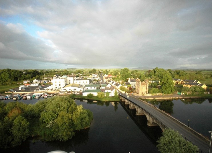
Aerial view of Leighlinbridge looking west across the River Barrow.
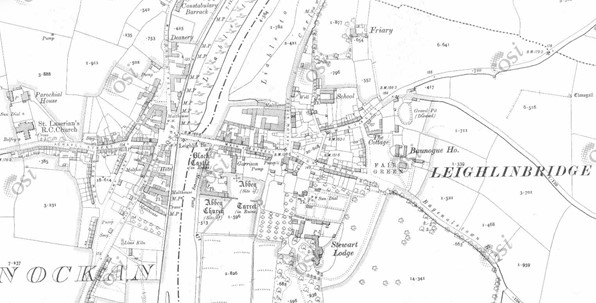
Historic Map 25 Inch (1888-1913) of Leighlinbridge (Source: www.osi.ie)
15.3.2.3 Population and Socio-Economic Profile
Population, Demographic and Nationality
According to 2016 Census data, the town has a population of 914, representing an increase of 10% on the previous 2011 Census figure of 828. There was substantial population growth of 22.85% in the 2006 to 2011 intercensal period. The Core Strategy allocates an increase of 226 people in the town by 2028.
The 0-24 age group in Leighlinbridge in 2016 stood at 31.6%, which was marginally below the national figure of 33%. The proportion of infants at 7.3% (0-4 years) and children at 12.6% (5-12 years) in the town was generally consistent with national and county averages.
The 65+ age group represented 13% of the population of the town in 2016, which was comparable to a national figure of 13.4% and a County figure of 12.9%.
Non-Irish nationals accounted for 8.9% of the town’s population in 2016, which is below the share for the State (11.4%) and the County (10.5%).
Economic Profile
The 2016 Census identified that there were 460 persons in the labour force i.e. aged 15 years and over who were able to work; excluding students, retired, those looking after family or unable to work due to illness or disability. Of this labour force 83.9% were in employment (386 persons).
At 22%, professional services were the biggest sector of employment, followed by commerce and trade (18.1%), and manufacturing industries (14.8%). The agricultural, forestry and fishing sector is also a significant employer for Leighlinbridge (9.6%).
The unemployment rate for Leighlinbridge in 2016 stood at 16.1%, which was higher than the figure for the state of 12.9%. In terms of persons not in the labour force, 13.7% were retired, 8% were students (aged 15yrs and over), 4% were unable to work due to permanent sickness or disability, and 8.5% were categorised as looking after home/family.
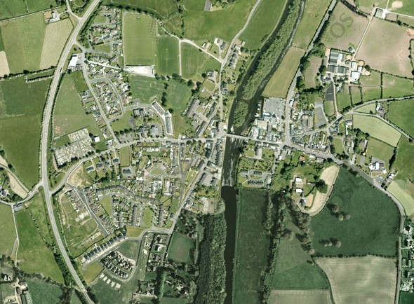
Aerial Aerial imagery of Leighlinbridge captured between 2013-2018 (Source: www.osi.ie)
15.3.2.4 Housing
In terms of household numbers, a total of 356 were recorded in the 2016 Census. Of this number, one and two-person households comprised 59% of all households, which was above the national figure of 52%. Between the years 2001 to 2010 38.3% of the town’s housing stock was built.
In the 2016 Census, 60% of housing units were owner occupied. Socially rented Local Authority housing accounted for 20% of households.
The housing target for Leighlinbridge identified in the Core Strategy in Chapter 2 is 99 new residential units over the Plan period from 2022-2028. It is an objective of the Council to seek to encourage the provision of additional new housing on appropriately zoned lands and in particular the completion of Ballyknockan Manor and Friars Lough located to the west of the town. The Plan will also promote a policy of consolidation focused on localised growth through the development of infill and brownfield lands and mixed-use development of town centre lands. Any development shall respect the character and setting of the town and make a positive contribution to its built environment.
15.3.2.5 Social Infrastructure
A variety of services and local facilities are provided and include:
- Pre-school childcare provided by a playschool Community Creche.
- Leighlinbridge National School catering for 176 pupils. (Secondary education is catered for in the nearby towns of Muinebheag and Carlow Town).
- Healthcare services are provided by the Leighlinbridge Health Centre. providing a range of primary care and community services for the town.
- Beechwood Nursing Home located to the north of the town.
Other community services in Leighlinbridge include a playground, a community hall, churches, and a dedicated sheltered housing initiative for the elderly.
Sports facilities include playing pitches, located at the northern side of the town and with access from Milford Street. There are also tennis courts at the eastern end of the town, maintained by the local tennis club.
Leighlinbridge also has a number of gardens that have been designed and built by the local community and make an important contribution to local recreation and amenity. These include the Memorial Garden, Millennium Garden, Vivaldi Garden and Sculpture Garden. The Sculpture Garden is dedicated to well known people from the town including John Tyndall, Cardinal Patrick Francis Moran and Captain (brevet Lt.-Col.) Myles Walter Keogh.
The River Barrow flowing through the town is the principal focal point for recreation, particularly boating and the walking trail along the Barrow Way.
15.3.2.6 Economic Development
Leighlinbridge is designated as a level 3 Small Town under the Retail Hierarchy for the County. In general terms a Level 3 Small Town has a more limited retail role and function than higher order settlements, with provision typically restricted to services and convenience shopping.
While Leighlinbridge is a busy market town that serves the local population and wider rural hinterland, it is also evident that tourism is a key component of the town’s economy. The town centre is very compact in nature, and contains a mix of retail, commercial and residential uses. The high level of residential occupancy within the town centre serves as an important element in sustaining the town’s economic vibrancy. The town is also surrounded by a strong agricultural hinterland including Ballyhane Stud located to the east of the town.
Commercial premises in the town comprise primarily independent retailers (grocers, pharmacist, newsagent, barbers, butchers), in addition to restaurants/takeaways, public houses, B & Bs and a hotel. There are two petrol services stations in the town, one on its eastern side, and one to the west close to the R448 and accessed off the Seskin Road.
Carlow Arboretum is located to the north of the town centre, with access from the R448 and Milford Road. The Arboretum is an award-winning commercial premises and key tourist/visitor attraction in the area, incorporating a garden centre, visitor gardens, children’s play centre, restaurant, and café.
Tourism is a core component of the local economy. The Lord Bagenal Inn / hotel, and Rathvinden House cater for a local market together with the growing tourism industry in the town. Self-catering tourist accommodation is also provided by the Garrison Holiday Centre, located to the south of the town and on the east bank of the River Barrow. With anticipated expansion of the tourist industry, there may be a requirement for further guest accommodation facilities to cater for increased visitor numbers.
15.3.2.7 Vacant / Derelict Units and Sites
Vacancy and dereliction can have an adverse effect on the vitality and visual amenity of a town. There is a low level of vacant and/or derelict units in the town. Where the units are vacant, attempts have been made to reduce the impact on the character and vitality of the street by maintaining the building façade.
In 2016, 12% of housing units were recorded as vacant in Leighlinbridge, which was higher than National (9.1%) and County (8%) averages for the same year.
15.3.2.8 Regeneration / Redevelopment Opportunities
The Council promotes and supports the use of previously developed brownfield and infill opportunity sites within the established built footprint of Leighlinbridge, as well as the redevelopment of existing sites and buildings. This will contribute to:
- Securing more compact and sustainable growth.
- Enhancing the public realm and overall character and appearance of the town.
- Retaining and increasing vibrancy and vitality in the town centre, including viability for local services, shops, and public transport.
- Increased opportunities for sustainable travel such as walking and cycling.
Development proposals on brownfield, infill, and backland sites must be accompanied by a Site Brief. The Site Brief must demonstrate how a proposal incorporates principles of good urban design and placemaking as contained in Chapter 12, as well as compliance with national policy and guidance on the achievement of compact growth.
15.3.2.9 Intervention Area – Former Factory Site
This former knitting factory site (c.0.2ha) is situated within a predominantly residential area at the eastern end of the town. The factory has been closed for approx. 11 years, and its vacant unused appearance, including boundaries and unused buildings and sheds, detract from the character and appearance of the town. The site has an existing entrance onto Tullow Street, is adjoined by the town’s tennis club to the east, and by School Lane to the west.
The redevelopment of this vacant and underutilised brownfield site offers potential to rejuvenate this area of the town by providing a suitably scaled residential development within an existing built-up area, that is accessible and within walking distance of local services and amenities.
Any development proposals for the site should be informed by the existing character and built fabric of this scenic town, and by Chapter 12 in relation to good urban design and placemaking.
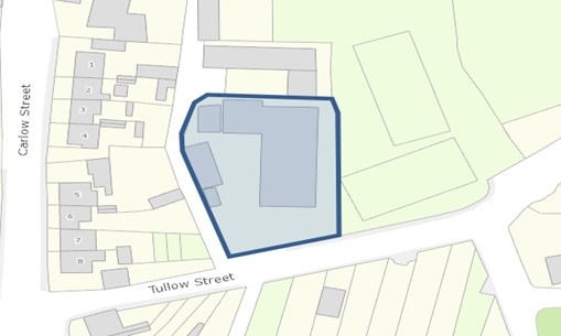
Map 15.3.2: Intervention Area – Former Factory Site
15.3.2.10 Movement and Transport
Leighlinbridge is served by the R448 regional route which bypasses the town. The M9 is accessible c. 4km north of the town and off the R448 at Junction 6 interchange (Carlow South). The R705 which traverses the town centre provides direct access to Muinebheag/Royal Oak at a distance of 5km to the south. Local roads radiating outwards from the town provide linkages with the rural hinterland as well as with towns and villages such as Tullow, Fenagh and Nurney.
Leighlinbridge is proximate to Muine Bheag Rail Station which has access to the Dublin /Waterford railway route. Bus Éireann operate direct bus services daily between Leighlinbridge and Carlow Town, and there are also services to Kilkenny and Dublin City. J.J. Kavanagh and Sons’ bus service also provide routes between Carlow Town and Kilkenny City that serve Leighlinbridge.
The River Barrow in Leighlinbridge, which historically served as an important trade link for the town, now functions as an important walking and recreational route along the Barrow Way.
There are no significant traffic issues in Leighlinbridge. Footpaths have been widely upgraded in the town but are narrow in places. The extension of footpaths along the Carlow Road and along Milford Road which link the town with Beechwood Nursing Home and Carlow Arboretum would improve connectivity with key services within the town. There are no designated cycle paths throughout the town.
On-street parking is widely available and there are a number of small, designated car parks at viewing points. In some cases, parking on footpaths impedes traffic flows along the narrow streets, while also inhibiting pedestrian mobility and movement on the footpaths.
Information signage is in place in Leighlinbridge, with clear direction to the town’s amenities and attractions, as well as to attractions outside of the town centre.
15.3.2.11 Water and Environmental Services
From 2020 Irish Water data, the existing design capacity of the Muinebheag and Leighlinbridge WWTP is 5,500 PE. A planned upgrade to the plant by Irish Water is to be completed by 2024. This will increase its design capacity to 9,200 PE.
Water in Leighlinbridge is provided by a borehole source at the Old Leighlin Road. This is a high-quality source and has spare capacity.
Domestic, commercial and industrial waste are collected and disposed of by private operators. Leighlinbridge Recycling Bring Bank is located off St. Lazerian’s Street.
The Council encourages recycling and the minimisation of waste through its environmental education programme and the Green-Schools programme.
15.3.2.12 Public Realm
The appearance of the built environment is well presented and maintained, and there is extensive planting throughout, with existing trees and stone walls contributing to the visual amenity and character of the area. The local community have created a number of public gardens throughout the town which enhance its character and appearance considerably.
The River Barrow makes an important contribution to the appearance of the public realm of the town. The river is also a rich natural asset that provides valuable biodiversity in the area.
Leighlinbridge has been the recipient of many environmental awards including regional winner in the National Tidy Towns Competition, first in the Barrow Awards and Carlow’s Floral Pride and overall national winner in Ireland’s Green Town 2000. It was also a gold medal winner in the European Entente Florale competition in 2001 for its display of flowers, trees, and relaxing parks. The town performs well in local events such as Carlow’s Pride of Place and the Carlow Litter Action League.
The town has secured funding under the Town and Village Renewal Scheme for public realm improvements. To date, this funding provided for upgrades to the playground and footpaths, improved signage, the erection of a monument to John Tyndall, and the painting of the railings along the bridge.
The Council in co-operation with local communities, businesses and other relevant stakeholders are seeking to continually improve the physical presentation and appeal of many towns in the County such as Leighlinbridge, both through the planning process, initiatives such as Pride of Place, County Tidy Towns, and through funding from the Town and Village Renewal Scheme.
15.3.2.13 Natural Heritage
The River Barrow is an important natural feature in Leighlinbridge and is designated for protection as a Special Area of Conservation (SAC). The Council has a statutory obligation to conserve and protect this SAC. Existing trees, hedgerows and green infrastructural assets are important natural heritage features of the town.
15.3.2.14 Architectural Heritage
Much of the ancient fabric of Leighlinbridge, an historic town, remains intact. The more notable built heritage features include the bridge spanning the River Barrow, Black Castle, the ruins of a 13th century Carmelite priory, and the remaining Malthouses.
The ‘Black Castle’ was founded by Hugh de Lacy in 1181 and constituted one of the earliest Norman defensive structures in the region. This earlier structure was incorporated in a later castle (now ruinous) built by Sir Edward Bellingham in 1547. Below the castle lies the ruin of the Carmelite priory, the first in Ireland which was built in 1270.
The bridge at Leighlinbridge confirmed the settlement’s strategic significance. A crossing at this point is believed to have been important since the 10th century. Around 1320 a stone bridge was built and although redundant by the mid-17th century, it was rebuilt and much of the bridge from this period remains in the present structure.
The examples referred to, as well as numerous other buildings and structures in Leighlinbridge, are recorded in the Record of Protected Structures and by the NIAH (See Table 15.3.2.1). Chapter 10 of this Plan outlines policies and objectives for protecting architectural heritage within the county.
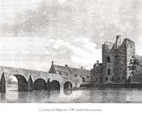
Historic print of the medieval town of Leighlinbridge.
|
RPS |
NIAH |
Description |
Address |
|---|---|---|---|
|
CW31
|
10400506
|
A warehouse of circa 1840. |
Warehouse, (now apartments), Church Street, Leighlinbridge |
|
CW32
|
10400507
|
A seven-bay, five-storey, gable-ended warehouse of circa 1830. |
E. Cullen & Son’s, Milford Street, Leighlinbridge |
|
CW33
|
10400508
|
A very fine, eight arched bridge, over the river Barrow. It dates from 1789 and has triangular-shed cutwaters and round-headed arches. It is said to be a rebuilding of a bridge of 1650. |
Barrow Bridge, Leighlinbridge |
|
CW58 |
10400511 |
A small, three-bay, two-storey country house with a basement, dating from circa 1750. |
Steward Lodge, Fair Green, Leighlinbridge |
|
CW59 |
10400510 |
A three-bay, three-storey, gable-fronted house of circa 1700. |
Higgin’s , Main Street, Leighlinbridge |
|
CW151 |
|
A three-bay, two-storey, end of terrace house with a pitched roof. |
Parochial House, Leighlinbridge |
|
CW152 |
|
A three-bay, three-storey, gable-ended, late-18th century house. |
House, Milford Road, Leighlinbridge |
|
CW153 |
|
A five-bay, two-storey, gable-ended, early-19th century house over a basement. |
House, Church Street, Leighlinbridge |
|
CW154 |
10400502 |
Essentially a three-bay, two-storey country house dating from circa 1810. |
Rathviden House, Leighlinbridge |
|
CW155 |
10400503 |
A T-plan church of circa 1820. |
St. Lazerian’s Catholic Church, Leighlinbridge |
|
CW156 |
10400504
|
A detached, five-bay, two-storey house over a basement. The house dates from circa 1830. |
Leighlinbridge Presbytery, Leighlinbridge |
|
CW157 |
10400501 |
Ruins of a First Fruits church of circa 1810. |
Church of Ireland Church, Leighlinbridge |
|
CW158
|
|
At the rear of C. Murphys house is a large, U-plan complex of early-19th century warehouses.
|
C. Murphy Warehouse, Church Street, Leighlinbridge |
Table 15.3.2.1: Protected Structures and NIAH Listings for Leighlinbridge
15.3.2.15 Archaeology
Leighlinbridge has a number of features that are recorded in the sites and monument record. Some of which are also listed as protected structures. Chapter 10 of this Plan outlines policies and objectives for protecting archaeology within the county.
|
Ref. No |
Address |
Item |
|---|---|---|
|
CW012-068 |
Ballyknockan, Leighlinbridge |
Enclosure |
|
CW012-069 |
Ballyknockan, Leighlinbridge |
Designed Landscape Feature |
|
CW012-070 |
Leighlinbridge |
Historic Town |
|
CW012-070001 |
Leighlinbridge |
Town Defences |
|
CW012-070002 |
Leighlinbridge |
Bridge |
|
CW012-070003 |
Leighlinbridge |
Castle - Tower House |
|
CW012-070005 |
Leighlinbridge |
Religious House – Carmelite Friars |
|
CW012-070006 |
Leighlinbridge |
Flat Cemetery |
|
CW012-071 |
Leighlinbridge |
Enclosure |
|
CW012-082001 |
Coneykeare, Leighlinbridge |
Ring-ditch |
|
CW012-082002 |
Coneykeare, Leighlinbridge |
Ring-ditch |
|
CW012-082003 |
Coneykeare, Leighlinbridge |
Ring-ditch |
|
CW012-082004 |
Coneykeare, Leighlinbridge |
Ring-ditch |
|
CW012-082005 |
Coneykeare, Leighlinbridge |
Ring-ditch |
|
CW012-082006 |
Coneykeare, Leighlinbridge |
Ring-ditch |
|
CW012-086 |
Leighlinbridge |
Standing Stone |
|
CW016-001001 |
Ballyknockan, Leighlinbridge |
Church |
|
CW016-001002 |
Ballyknockan, Leighlinbridge |
Graveyard |
|
CW016-002 |
Ballyknockan, Leighlinbridge |
Boundary Stone |
|
CW016-003 |
Ballyknockan, Leighlinbridge |
Castle - motte |
|
CW016-090 |
Ballyknockan, Leighlinbridge |
Redundant Record |
|
CW016-125 |
Leighlinbridge |
Enclosure |
Table 15.3.2.2: Recorded Monuments in Leighlinbridge
15.3.2.16 Land Use Zoning
Lands within the development boundary of Leighlinbridge are zoned for various uses. Zoning objectives are contained in Chapter 16 Development Management Standards.
15.3.2.17 Leighlinbridge - Policies
The policies outlined hereunder for Leighlinbridge are in addition to policies and objectives included in all other chapters of this Plan, and therefore should be read in conjunction with same, including the Development Management Standards in Chapter 16.
Settlement Form and Function
It is the policy of the Council to:
| LB. P1: | Support the role of Leighlinbridge by facilitating development that will contribute to the character and services function of the town while complementing and enhancing the quality of its attractive built and natural environment by delivering a high-quality standard of design. |
| LB. P2: | Preserve the character of the town by requiring that the height, scale, design and materials of any proposed development respects the character and distinctive built heritage of the town and does not diminish its sense of place. |
| LB. P3: | Retain traditional painted timber shopfronts and traditional advertisement styles and ensure any new shopfronts or advertisements do not detract or erode the special character of the town. |
Regeneration/Redevelopment
It is the policy of the Council to:
| LB. P4: | Promote and support the use of previously developed brownfield, infill, derelict and backland sites in Leighlinbridge, including the redevelopment of existing sites and buildings, and to continue to identify regeneration opportunities in the town during the lifetime of this Plan. |
| LB. P5: | Encourage the redevelopment of the Former Factory Site (See Map 15.3.2) with appropriately designed residential development of a scale that respects the scenic quality and built heritage of the town and contributes to high quality urban design and placemaking. |
Economic Development
It is the policy of the Council to:
| LB. P6: | Encourage the provision of retail and services to consolidate and strengthen the role of Leighlinbridge in meeting the needs of its population and its rural hinterland. |
| LB. P7: | Facilitate and encourage the expansion of established enterprises operating in Leighlinbridge, to promote additional enterprise and employment opportunities and to ensure that future development is compatible with the character, scale and function of the town. |
| LB. P8: | To maximise spin-offs from the Arboretum located on the edge of the settlement by seeking to improve pedestrian connectivity from the site along the public road and the River Barrow to the Town Centre subject to the requirements of the Habitats Directive. |
| LB. P9: | Advance Leighlinbridge as a tourism hub and support further growth of the tourism sector by harnessing the built and natural heritage characteristics of the town including the provision of walking and heritage trails throughout the town. |
| LB. P10: | Support tourism related uses, activities and amenities that complement the natural and built heritage assets of the area including the River Barrow subject to environmental assessments. |
| LB. P11: | Support the provision of co-working spaces within the town centre facilitating the establishment of new businesses and remote working opportunities for residents of the town. |
Movement and Transport
It is the policy of the Council to:
| LB. P12: | Maintain and improve where appropriate the local road network /streets and to improve the quality, aesthetics and width, where appropriate, of all footpaths in the town, to promote active travel measures and to improve access for mobility impaired. |
| LB. P13: | Promote and facilitate the development of walkways and cycleways at appropriate locations throughout the town to encourage sustainable transport. |
Housing
It is the policy of the Council to:
| LB. P14: | Seek to encourage and facilitate the re-use and regeneration of Ballyknockan Manor and Friars Lough (incomplete estates) for residential purposes as indicated on the land-use zoning Map. |
| LB. P15: | Support and encourage residential development on new residential land, under-utilised and/or vacant lands including ‘infill’ and ‘brownfield’ sites, subject to a high standard of design and layout being achieved, and compliance with proper planning and environmental considerations. |
| LB. P16: | Ensure that future growth is balanced and sustainable and is appropriate to the scale, size and character of the existing town. |
Social Infrastructure
It is the policy of the Council to:
| LB. P17: | Seek to enhance and provide recreational and community amenity facilities in Leighlinbridge to meet the needs of the residential population and surrounding rural hinterland. |
| LB. P18: | Support the development of zoned open space and amenity lands for the provision of appropriate amenity facilities for the local community. |
Water and Environmental Services
It is the policy of the Council to:
| LB. P19: | Liaise with and support Irish Water to ensure adequate water services are in place to meet the development needs of Leighlinbridge within the Plan period and beyond. |
Public Realm
It is the policy of the Council to:
| LB. P20: | Encourage public realm enhancements to the centre of the town and to facilitate mixed town centre uses to ensure the continued vitality and vibrancy of the town centre. |
| LB. P21: | Continue to support public realm improvements in the town, including where appropriate, the provision of appropriate signage, public seating, open space, hard and soft landscaping, retention of old stone walls and improvements to the public road and footpath network. |
| LB. P22: | Promote and support the utilisation of available funding and the implementation of any projects or schemes for which funding has been received that would contribute towards the maintenance and improvement of the public realm of the town. |
Built and Natural Heritage
It is the policy of the Council to:
| LB. P23: | Support the retention of buildings with architectural merit, significant architectural features, historic /heritage structures and archaeological sites that contribute to the towns character and setting. |
| LB. P24: | Protect individual trees, groups of trees, hedgerows and stone walls in so far as possible on all approach roads and within the town which contribute significantly to the character and visual amenity of the town. |
| LB. P25: | Require development proposals to outline how they integrate / respond to green infrastructure and contribute to the development and protection of green infrastructural assets in the town and wider area. |
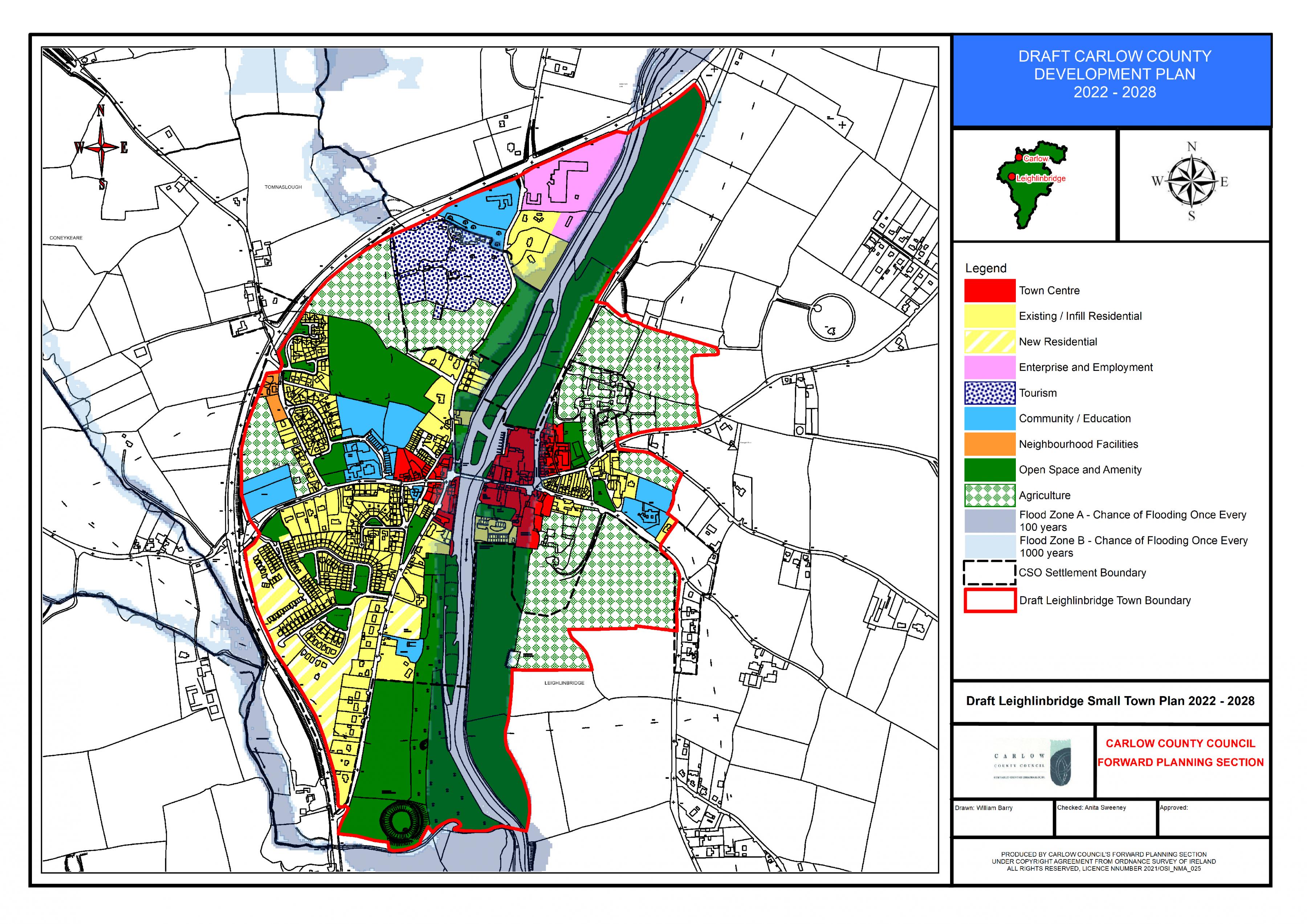
Leighlinbridge Land Use Zoning Map
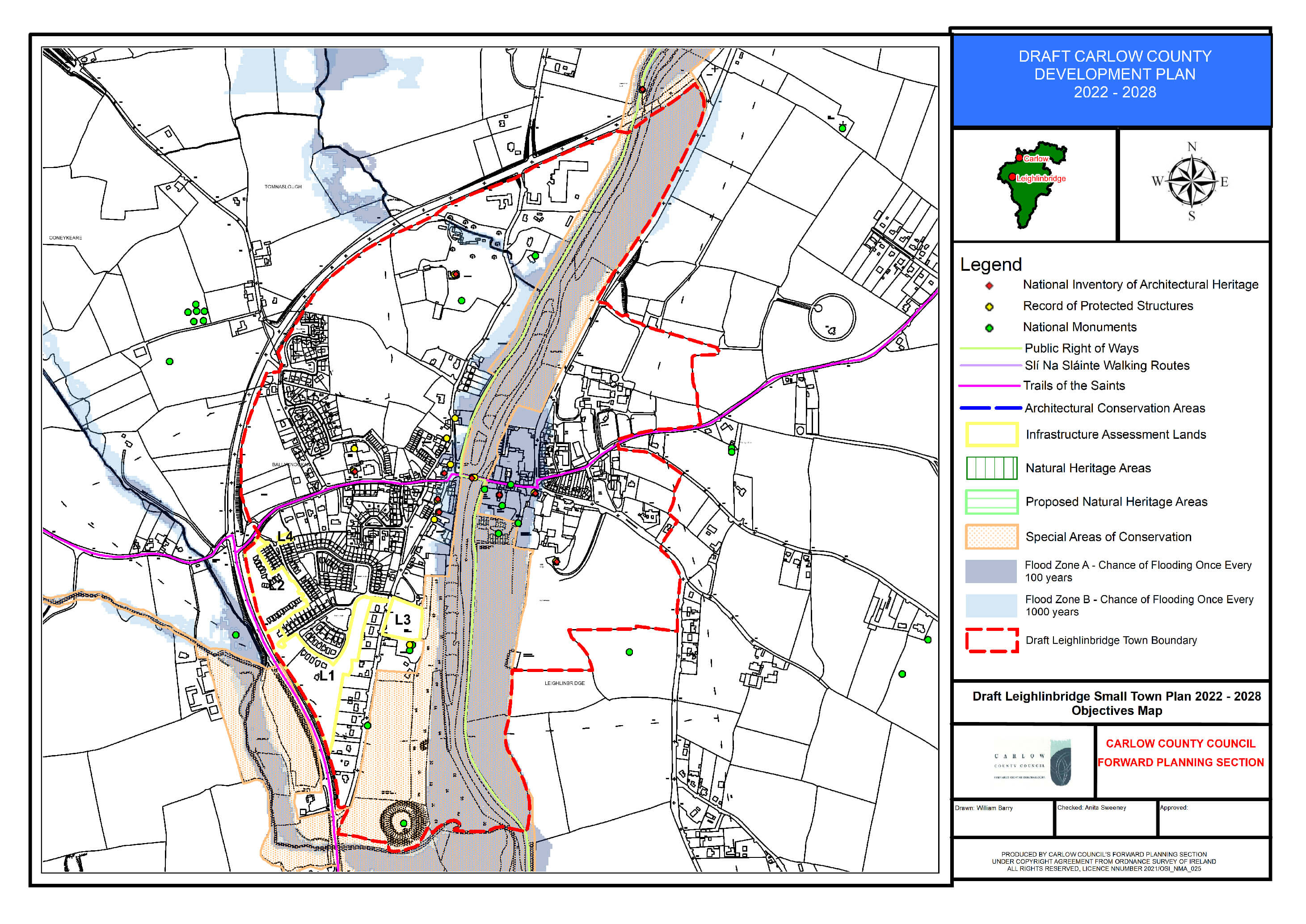
Leighlinbridge Objectives Map